
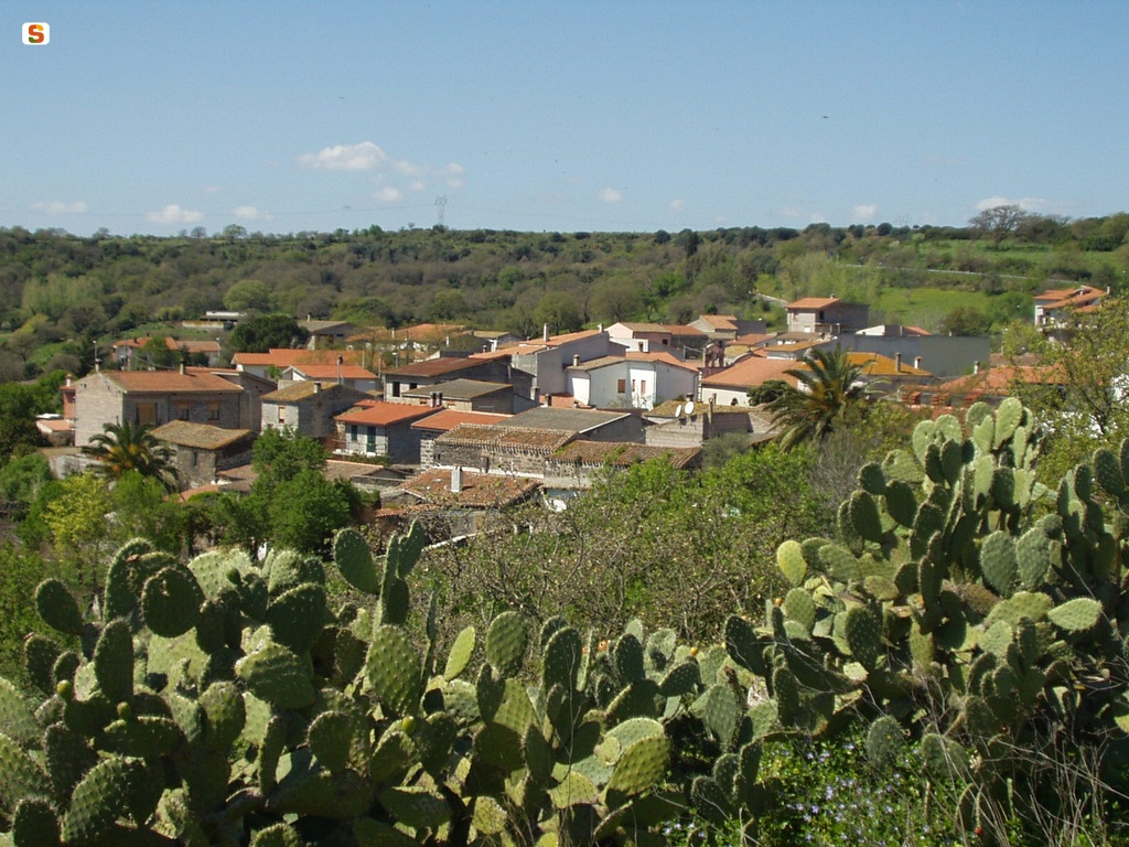
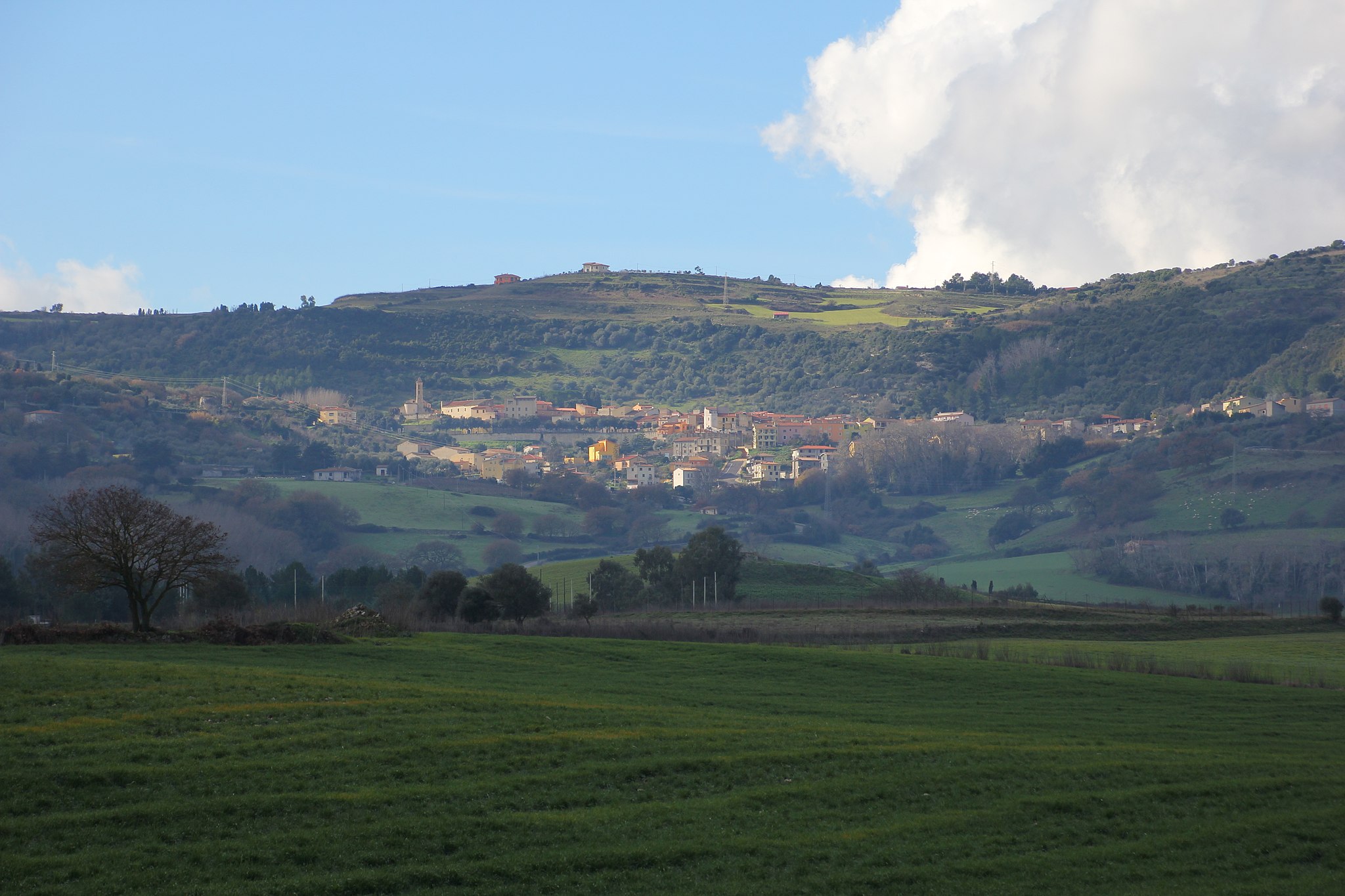
Boroneddu
Boroneddu is set on a basalt plateau that slopes gently down to the valley of Lake Omodeo, a natural oasis that is perfect for long walks, surrounded by holm oaks and Mediterranean brush, against the backdrop of the Barigadu mountains. This tiny village with a population of 150 falls into the territory of Guilcer, and has been an independent municipality since 1988, after being under the governance of Ghilarza for 60 years. Once part of the Arborea Giudicato, it is mentioned for the first time in the condaghe of Santa Maria di Bonarcado with its original name of Orene - elsewhere written as Borene. Of the original medieval village, only the Novenario di San Salvatore remains, two kilometres outside the village. The church, which has been renovated and expanded over the centuries, has its own muristenes, lodgings for pilgrims during the novenas.
The sanctuary holds a truncated-cone-shaped basalt keystone bearing a bas-relief Byzantine cross, and is the location of the patron saint's celebrations in mid-September. The village is laid out around the parish church of San Lorenzo Martire, built in 1886 using square, brown basalt blocks. The facade is divided into three sections by pillars, and has a belfry. The most interesting attraction in the village is the small Sardinian folklore museum, which explores the mysterious world of the island's fairy tales - including those by artist Maria Lai - "populated" by characters such as the Maschinganna, Janas, Luxia Arrabiosa and others: a world narrated from generation to generation around the fireplace. The museum has a narrative path composed of large panels, including su pinnettu, a typical hut used by shepherds and farmers, and the typical farming homes, where the figure of the woman is dominant: weaving fabric, making and baking bread in the oven. One of the unmissable events of Boroneddu is the Bonfire of Sant'Antonio Abate in mid-January, when sa panischedda is offered (a pastry made with sapa, walnuts and almonds), the asparagus and wild fennel festival in March, and the prickly pear festival in the summer, where you can taste dishes made with the fruit picked from the plants that grow and flourish all along the basalt ridges around the village.
The root of the name (Bor-) is linked to "spring", confirmed by the presence of the nearby River Tirso, or to the surrounding "crown" of nuraghes. The fertile land has attracted stable settlements ever since the Neolithic, the most famous of which is the su Montigu complex. Not to mention the nuraghes of Cortinas, Fiscas, Ispinosu, Malosa, Trubeli and at the highest point, the Ostele nuraghe.
Bono
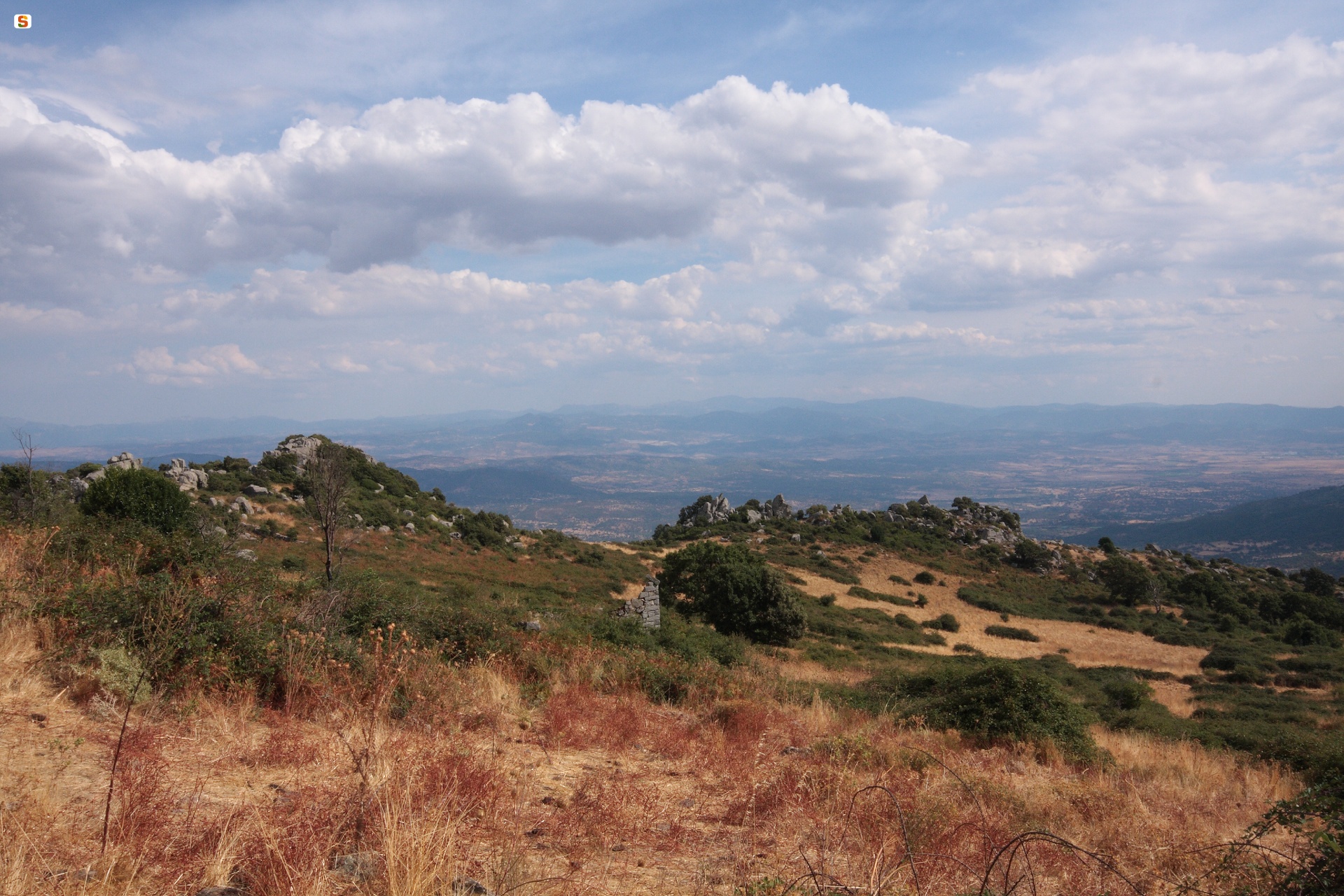
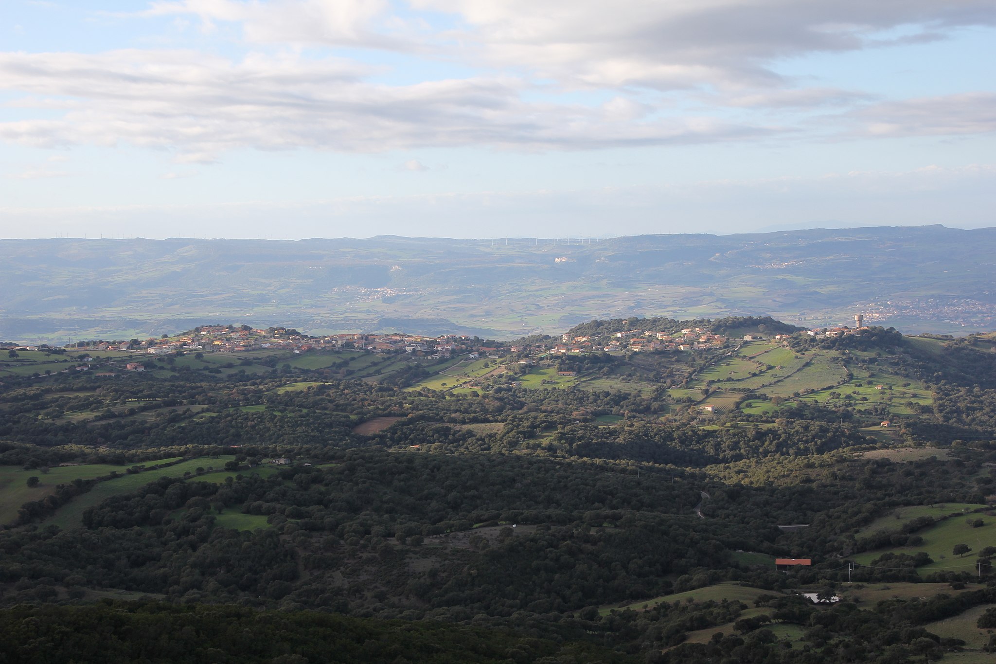
Perched at more than 500m above sea level, on the slopes of monte Rasu, surrounded by a wide variety of landscapes. In the Province of Sassari, Bono is considered Goceano’s capital and boasts 3,600 inhabitants and strong ties with the Nuoro area. It’s a typical farming and pastoral town with artisanal traditions: iron mongering, wood carving, weaving on ancient looms, and baking. The surrounding landscape is a sequence of plains and hills that spans from the Tirso Valley to mount Rasu, on top of which is sa Punta Manna (1259 m). On its slopes is the enchanting sos Nibberos, home to Italy’s most expansive yew tree forest, a natural monument well worth a visit, with millenary trees that exceed heights of 15 m. At the nature oasis of mount Pisanu they have planted such species as Atlantic cedar, oak, giant white cedar and white pine in and around the small lakes.
Between the XII and XIII centuries, when Bono was under the jurisdiction of the Giudicato of Torres, a Romanesque-Pisan church that is now the parish church of San Michele Arcangelo was built. It was enlarged in the XVI century and is home to a XV century wooden statue of St. Michael and a XIV century gilded silver chalice. The pink trachyte façade dates to the XIV century and has been embellished with a door graced with slender columns and pensile arches, as well as a lovely rosette that came from a monastery on Mt Rasu, one of the island’s oldest. The same monastery was also the source of the statue of St. Francis of Assisi which is now housed, together with other saint statues, in the church of San Raimondo. The saint is celebrated in late August-early September with a procession featuring traditional costumes, carts pulled by adorned bulls, knights and antique musical instruments. The bonfires in honour of Sant’Antonio Abate on 16 January are especially heartfelt, paired with offerings of wine and cogones, a local version of focaccia bread. The sanctuary named after him dates to the XVIII century, as does the one dedicated to Sant’Efisio, while the one bearing the name of San Giovanni Battista is from the XVI century. The far more modern Nostra Signora di Bonaria, home to a lovely simulacrum of the Virgin, was built in 2001. Every 30 November the townspeople celebrate the night of Sant’Andria, a celebration not unlike Halloween. In the lower outskirts of the town are five country churches, the remnants of what was once the settlement of Lorthis, the purported origin of the local Bono population. The oldest of these churches is Romanesque and dedicated to the martyrs of Porto Torres: Gavino, Proto and Giannuario. The others are Santa Restituta, featuring a typical cumbessias, San Nicola, boasting a Romanesque facade, Santa Barbara, built over the ruins of a nuraghe, and Sant’Ambrogio.
During the Savoy reign, after Bono’s most celebrated son and XIX century Sardinian hero, Giovanni Maria Angioy (1796), got involved in anti-feudal revolts, the town was attacked by Piemontese troops. A mural on Piazza Bialada done by Liliana Canu commemorates the struggles and its hero.
Curcuris
The territory is a rectangle of just eight square kilometres in the foothills of Mount Arci park, in an area of gentle hills crossed by the Rio sa Murta, partly forested and partly used to grow cereals and forage for pasture. Curcuris is a village of 300 inhabitants in the eastern part of Marmilla; it has been an independent municipality since 1979, after being under the governance of Ales for more than half a century. During the period of the Giudicati, it was under the Parte Usellus in the Arborea Giudicato, before passing to the Aragonese Crown and later becoming a Carroz feud. The village has medieval origins, thanks to the concentration of ancient, decentred agricultural and sheep-farming settlements, while the territory has been inhabited since prehistoric times, in particular during the Bronze Age, from when the Perda 'e Morguru and Soru nuraghes date. The Roman period also left visible traces.
Today, you can admire the village centre with its typical stone houses decorated with murales painted by Sardinian artists. The centre features the parish church of San Sebastiano, dating to the 16th century with late-Gothic forms that have undergone substantial changes over time. The large altar holds the statues of the Madonna del Rosario and the patron saint, who is celebrated on 20 January with a bonfire in the village square and an ancient rite said to bring a good harvest later in the year.
On the slopes of Mount Arci, cloaked in ancient forests of oak, pistacia and elm, Curcuris offers evocative panoramas. A walk on the hill of Santa Maria near the village will bring you to the rural church of Beata Vergine Assunta, built in Gothic style in 1380; today it is inside a wide enclosure with a large wooden door. The facade has a pointed doorway and the original belfry. The most heartfelt festivity, in honour of the Assunta, takes place on 15 August.
The abundant water supply and fertile land have always attracted settlers and encouraged the development of agriculture and sheep-farming, creating some ancient traditions such as the shearing festival, held at the beginning of summer each year and closed with a huge banquet.

Ittireddu
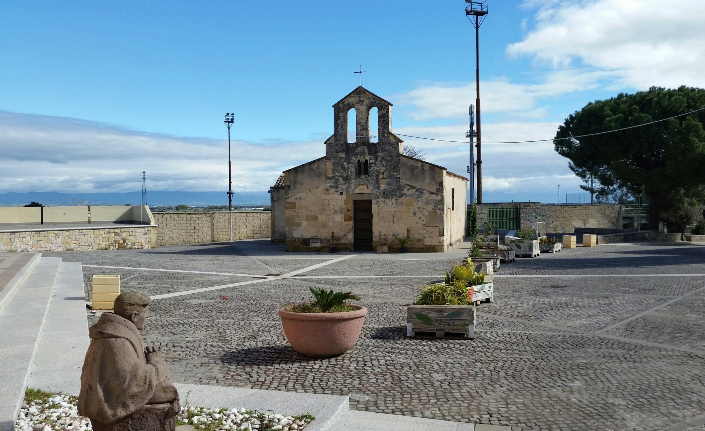
The village is spread out on Mount Ruiu, surrounded by extinct volcanoes dating back millions of years. Ittireddu, a small and ancient Logudoro village with just over 500 inhabitants, dates back to Byzantine times, when the church of Santa Croce was first built, although it has been rebuilt several times over the centuries. The name, literally "little Ittiri", dates back to 1626. Next to the church stands a fountain built in 1861 from blocks of rose tufo. The 12th century church of San Giacomo stands one kilometre out of the village. The walls are made from exposed stone blocks, typical of Sardinian Romanesque style, with a single room, covered by wooden trusses. The patron saint santu Jagu is celebrated at the end of July. Nostra Signora Inter Montes is also noteworthy, and hosts a 17th century wooden statue and three late-19th century sculptures by Giuseppe Sartorio.
The territory has been intensely settled since the late Neolithic, as shown by the 60 domus de Janas - many of which are multi-chamber, and a few single-chamber - dug into the tufo and grouped into five vast necropolises (plus three single tombs). The Mount Pira necropolis, which dates to somewhere between the late Neolithic and the Eneolithic (2800-2300 BC), has 26 burials. Once past the dromos (corridor) style entrance, you will see niches, cupules and bas-reliefs showing architectural elements of Neolithic homes, in an attempt to recreate the home environment within the tomb. Tomb 14, re-used in the Bronze Age, stands out: on the front, it has a cambered stele made from a single block, characteristic of nuraghic Giants' Tombs. The nuraghic civilisation is also well-represented by the sa Domo 'è s'Orku archaic "corridor" (9 metres long) nuraghe near the town. The Funtana 'è baule, on the other hand, is a holy well, the lower part of whose walls in blocks of trachyte tufo are extremely refined, with perfectly fitted stones. The Funtana nuraghe is a complex structure, with a main tower to which two more towers and a wall were added. The chamber has a seat-bench and there were once two stone "tables", now on display, along with containers, bowls and a four-handled jug containing twenty kilos of copper lingots, in the village's Civico museo archeologico ed etnografico. The museum also represents Ittireddu's farming and craft traditions. There are numerous traces of Roman inhabitation: the village was a mansio along the road to Turris Libisonis and Tibula. In the Olensas area, ten cisterns dug into the tufo rock were found, perhaps used to contain oil or olives (hence the name). Two olive presses and tanks for decanting oil stand a few metres away. On the border with Mores, two of the three original arches of the 18 metre Ponte 'etzu (old bridge) stand, built from black basalt and light coloured tufo. The funerary hypogeums of sa Fraigada, carved from the rock, are from the late Roman period.

Loculi
Loculi rests in the plain crossed by the River Sologo, an affluent of the River Cedrino, a few kilometres from Baronia, surrounded by hills and overlooked by the majestic, snowy profile of Mount Albo, the "Sardinian Dolomite". The village has a population of just over 500, and is 34 kilometres from Nuoro. The name is said to derive from locus, "holy forest" or "small place". It may have Phoenician or Punic origins, supported by the finding in 1959 of a jug from the period containing bronze objects and coins. The village has agricultural, sheep-farming, craft trade and religious traditions. Of the 17 churches existing from the 15th to 20th century, only the parish church of San Pietro e la Madonna de sa Defessa (the Defence) remains, and the patron saints are celebrated in late August and mid-January respectively. The rituals of the Holy Week are very popular. In the village centre stands sa Domo de sas artes e de sos mestieris, where you can discover the Baronia arts and crafts through the shots by photographer Carlo Bavagnoli. Part of the long ridge of Mount Albo falls into the territory of Loculi: the limestone bastion can offer evocative views along the marked paths. These paths, once used by charcoal burners and shepherds, climb right to the twin peaks of Turuddò and Catirina (1127 metres), through forests of ancient holm and oak trees. The area is a nature reserve inhabited by mouflons and surveyed by royal eagles. In the northern part, where the plants become sparse, you can admire a "lunar" landscape.
The territory of Loculi has been settled since the Neolithic, as shown by the domus de Japas dug from vertical cliffs, some "single chamber" (the domu of Pira 'è Tusu, Locurréris and Ena Longa), and others with more than one chamber (Tùrrighe and Puntèri). A megalithic dolmen-type burial in Santa Maria di Loculi dates to a period of passage between the pre-nuraghic and nuraghic ages. There are also nuraghic burials in the area: the Giant's tomb of s'Iscusorju ("hidden treasure"), around two kilometres from the town, is covered by pistacia trees, from which a corridor emerges, bordered by granite slabs in a "knife" layout, covered by jack-arched slabs. 15 kilometres from the village is the tomb of Ena Tunda, of which the lower part is preserved in the form of a long, apsed body, a rectangular corridor with a pointed ceiling and a semi-circular (exedra) entrance. The tomb of su Gollèi Lupu, with a cambered stele and gradually curving layout appears to be built over a previous dolmen: covering slabs are spread over the surrounding area. The nuraghes, which are linked, are positioned according to a strategic defensive design. A five metre high tower, entrance with architrave and part of the cell remain of the well-preserved Caraòcu (or Corricanu) nuraghe. The Preda Longa nuraghe is also very evocative.
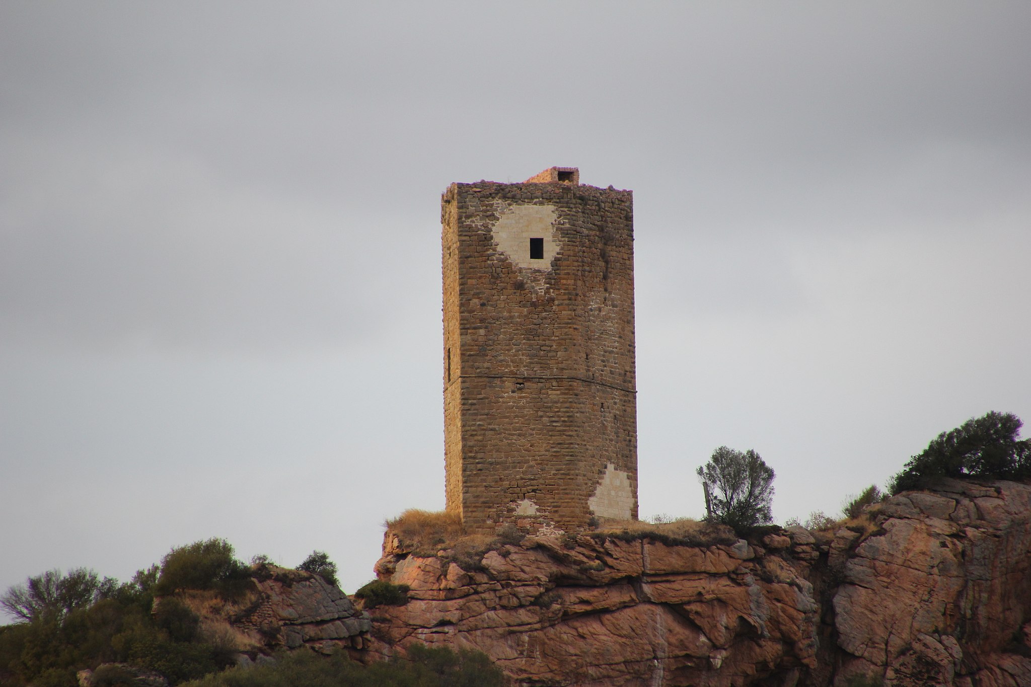
Casteldoria
An aura of mystery surrounds the ruins of a fortress near Santa Maria Coghinas, in the historical region of Anglona. Perching on the granite mountain known as monti di lu Casteddu (or Mount Urtigiu), along the Mount Ruju chain, Casteldoria (or Castello dei Doria) overlooks a fertile valley fed by the "healing" waters of the River Coghinas and Lake Casteldoria, where the Romans built an important bath complex. The castle was built around the 12th century by the Genoese Doria family, and passed from the Genoese dominion to the Aragonese, then to the Arborea Giudicato and lastly to the Malaspina family.
Only a few ruins remain of the fortress: parts of the walls, the remains of a chapel and a large cistern that was probably used to collect and store water. The famous tower, on the other hand, is well-preserved, and is an important part of the castle, built in large, rectangular granite blocks set in mortar. Twenty metres high, it has a pentagonal layout with the entrance on the north-eastern side. On the same side are two large, non-aligned openings, and a large window on the opposite side on the first floor. Inside, the castle has three wooden floors with a tiled roof and walkway. The last floor was created from what was originally a mezzanine floor before a terrace.
The castle, and in particular the tower, is surrounded by legends and myths that have been handed down over the generations and narrated by Nobel prize-winner Grazia Deledda in her Racconti Sardi (1894). One story tells of an intricate system of underground tunnels running between the castle and the chapel of San Giovanni in Viddacuia, (now known as Viddalba), on the opposite shore of Coghinas. The secret passage is said to have been used by the Doria family to get to church on feast days. The tunnels hide another secret - that of an explorer of the tunnels who discovered four large rooms. In one, there was a heavy iron door, which is said to protect the fabulous treasure of the Dorias. Deledda describes a "conca della moneta" (coin hollow) next to the castle, where popular stories say the Dorias minted coin. Here a large gold bell was said to stand, rung by a stone thrown from the top of the hollow. To the west of the tower, where the Dorias walked in the summer evenings, the high, impressive towers were said to overlook the river like guardians.
Cheremule
Cheremule is located next to Monte Cuccuruddu, the 680-metre cone of an extinct volcano, surrounded by green forests, in the historical region of Logudoro. A small town of less than 500 inhabitants, it took its name from cheremulite, a volcanic stone used in the second half of the 20th century for its insulating power. In fact, the town lies within a territory dotted with volcanic craters in Meilogu, becoming a protected natural monument in 1994, and prehistoric remnants of the Valle dei Nuraghi, with thirty complexes within a few hundred metres. The landscape is unusual and unique, with small hills that are sometimes pointed, sometimes rounded and sometimes cut by level plains.
Besides the nuraghe structures, there are also pre-Nuragic hypogenic necropolis within the territory, in particular the necropolis of Museddu with some Domus de Janas showing graffiti and bull protomes inside and outside. Moreover, there are some pinnettas scattered about, as characteristic conical pastoral stone constructions.
The main building is the parish church of San Gabriele Arcangelo, the patron saint celebrated on 29th September, built in the 16th century in Gothic-Aragonese forms. President of the Republic Francesco Cossiga chose this town to celebrate his funeral in 2010. From its slopes, extend the forest of Su Tippiri and the Monte Cuccuruddu pine forest, natural attractions that are not to be missed.
Decimoputzu
Set in the southern part of the Campidano plains, the town enjoys a very fertile soil crossed by several rivers, in particular the Rio Mannu. Decimoputzu is a town with a population of around 4500, and the name is first mentioned in the Middle Ages in the form of Decimopozzo or Decimo Pupussi when the territory was part of the Curatoria di Gippi within the Giudicato di Cagliari, and later the Reign of Sardinia, during the Aragonese-Spanish dominion. The town centre has two main churches: the parish church of Nostra Signora delle Grazie and the church of San Giorgio. The church of San Basilio is in the countryside outside the town. The surrounding land is characterised by greenhouses and vast fields of artichokes.
Its territory has been inhabited since the Neolithic. The most important nuragic sites are the nuraghes of Casteddu de Fanaris and Mount Idda, near which is a storage place where bronze items were found, including several swords. The ivory head of a Mycenaean soldier statue also dates to nuragic times, confirming trade with the Aegean civilisation, and found in the Mitza Purdia area. However, the most important finding is also the oldest, dating from the late Neolithic (3000 BC): the domu de Janas at sant'Iroxi, also known as the Warriors' Tomb, where 19 sword blades and arsenical copper, dating to the oldest nuragic phase (the Bonnanaro Culture, 1600 BC). The site, which was found by chance in 1987, was used for around 1500 years as a village and inhabited again in Roman times. It owes its name to the high number of skeletons (more than 200) laid in 13 chronological layers, and the rich warrior funeral goods found in the domu. These are now held at the National Archaeological Museum in Cagliari.
Erula
Originally a fraction of Perfugas, Erula was officially founded in 1988 by the ‘scorporo’ (separation) of the territory into four towns. A village of about 800 inhabitants within Anglona, Erula was built in the 19th century by around fifty Gallura farming families hailing from Aggius, Bortigiadas and Tempio Pausania, who imported traditions and dialectal variety. They settled in Su Sassu, once a forest also populated by deer, fallow deer and rare species of birds. Its origins can perhaps be traced back through the usual winter transhumance of the shepherds. The first houses were constructed in the Su Nuraghe district. The city centre is spread out, as is typical of Gallura stazzi, and extends to the main street. Erula was formed starting with the Chiesa di Nostra Signora del Sacro Cuore (1932), a parish that includes historic churches of the fractions Erulesi, in particular the sanctuary of Santa Vittoria di Su Sassu, in Romanesque style, possibly attributable to the Victorians of Marseilles. Parchments, intact to this day, reveal that it dates back to 1120 and are the oldest document on Sardinian churches.
The territory of Erula has been frequented since Neolithic times, as evidenced by the Domus de Janas near the town. Its wooded plateau and richness in springs was favourable for the Nuragic settlement, as is evidenced by the remains of the Erula nuraghe ancient megalithic edifices atop a hill, around which the first nuclei of the medieval village were built, Pubattu, Sa Toa (or, Poligosu) and the incomplete Nuragheddu, around which numerous boulders are scattered, all useful for the study of Nuragic architecture. Perched on an elevation is the nuraghe Spiene, known for the discovery (1925) of a votive ship with a deer protome, being the most valuable and important find ever discovered in Sardinia and preserved in the national archaeological museum of Cagliari. In the Sotgiu nuraghe, rather, lay shards of amphorae, pottery and Roman coins. An “elsa gammata” votive dagger found in the village is preserved in the archaeological museum of Perfugas. The plateau was also the site of Carthaginian trading traffic, as can be determined by a small treasure-trove of Punic coins, depicting the goddesses Tanit and Kore. As for the Roman age, large jars containing coins variously dated from the Julio-Claudian dynasty to the Antonine emperors were discovered. Also noteworthy is the discovery of a milestone indicating the one hundred and eightieth mile of the Tibula-Carales road.

Parco di Monserrato
Once the main aristocratic holding in the city, it is now six hectares of parkland with both natural and historic heritage, including an elegant monumental garden. Walking through the Monserrato park, nestling in a basin in the south-western suburbs of Sassari and restored to its former splendour in 2007 after extensive works, is like plunging into the past: the paths evoke the most important moments of its history, from its creation in the 17th century through to the 20th century. Over three and a half centuries, the park evolved from the original farmland to a refined garden with infinite plant varieties and architectural works embellishing the tree-lined paths. Walk through lindens, holly oaks, carobs, cypresses and pines. In the centre are six islands planted with orange trees. The irregular shape and variety of plantlife create unexpected clearings and "glimpses" with views over the city. Palms and erythrina plants alternate with olives and oleasters, citrus trees and pomegranates, box, horse chestnut, magnolias, willows, pistacia and Mediterranean plants. The park is further enhanced by the buildings constructed by the aristocratic families who owned it. The first of these was the Navarra family, Valencian merchants, followed by the Deliperi, including Giacomo Deliperi, the first mayor of the capital after the union between Piedmont and Sardinia. From 1866, it passed to deputy Giovanni Antonio Sanna, a cultured gentleman who was friends with Mazzini and Garibaldi; he was responsible for extending the "manor" and adding architectural features. He was followed by Baron Giordano Apostoli, who embraced the neo-Gothic ideals of Romanticism, erecting features such as the "Torre di Caccia" and the "Belvedere pond". This was the peak of its splendour. From 1921, the last owner was Nicolò Marquis of Suni (in Planargia).
A shady path through the olive grove leads to the "Green basin", and on to the "water temple" terrace, nearly ten metres long and six and a half high, in Neoclassical style. It appears almost unexpectedly, with a severe purity of line contrasting with the welcoming play of water. The facade is characterised by a portico with four limestone columns and vaulted ceiling. The temple overlooks a valley with a "nyphaeum" at its centre - a pool in the form of an elipsis decorated in Neoclassical style, nearly nine metres long and four wide. Continue on through the "linden walk" to the "house": from here, you can lean on the panoramic belvedere that leads onto "cypress walk". Don't miss the Neoclassic works added in the late 19th century, starting from the "frog pool", more than thirty metres long and ten wide. Resting sinuously against the slope, it is in perfect harmony with its natural setting. In the centre of the wall, water spurts from a vaulted passage. A short stairway leads to the monumental "Torre di Caccia", 14 metres high, with Guelph battlements. A narrow staircase climbs to the terrace, which offers a view that stretches as far as the sea. The lines of the facade are severe, although the building as a whole retains a softness. The "Caccia pool" acts as a wing to the water temple, emphasising its slight slope. Both the tower and the pool fit harmoniously into the overall complex of trees, lawns and paths as they slope gently down towards the valley. From the park, you can explore an ancient royal city: Fontana di Rosello, Piazza d’Italia and the Cattedrale di san Nicola di Bari are emblems of Sassari history and art.