
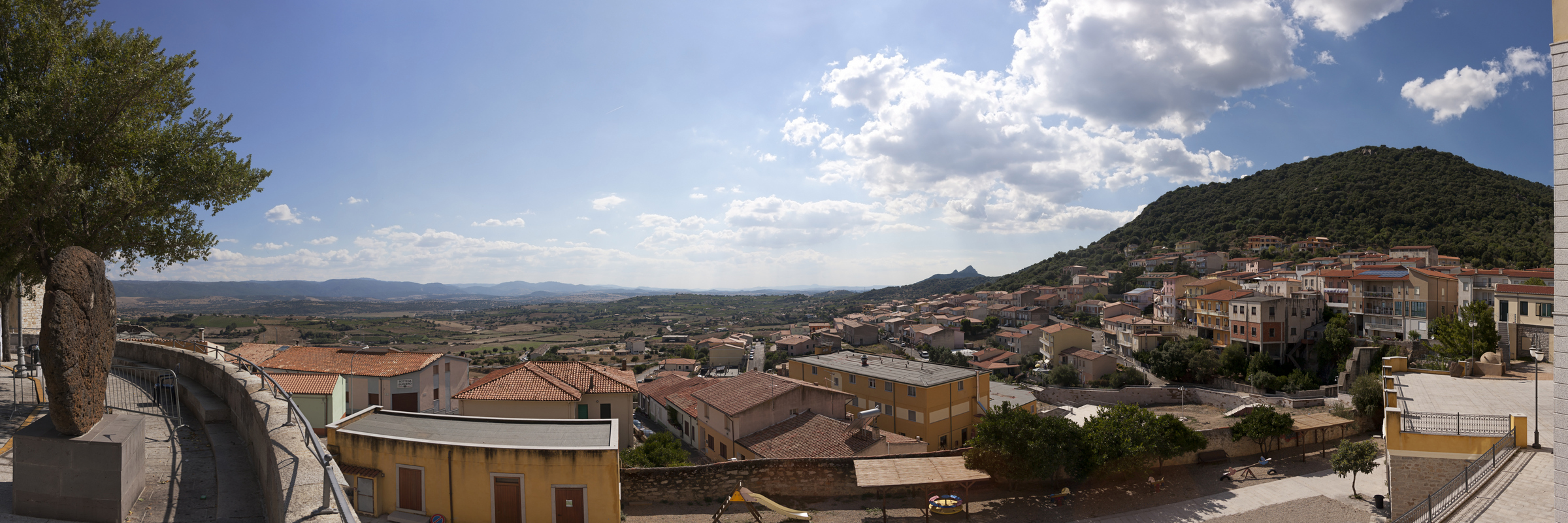
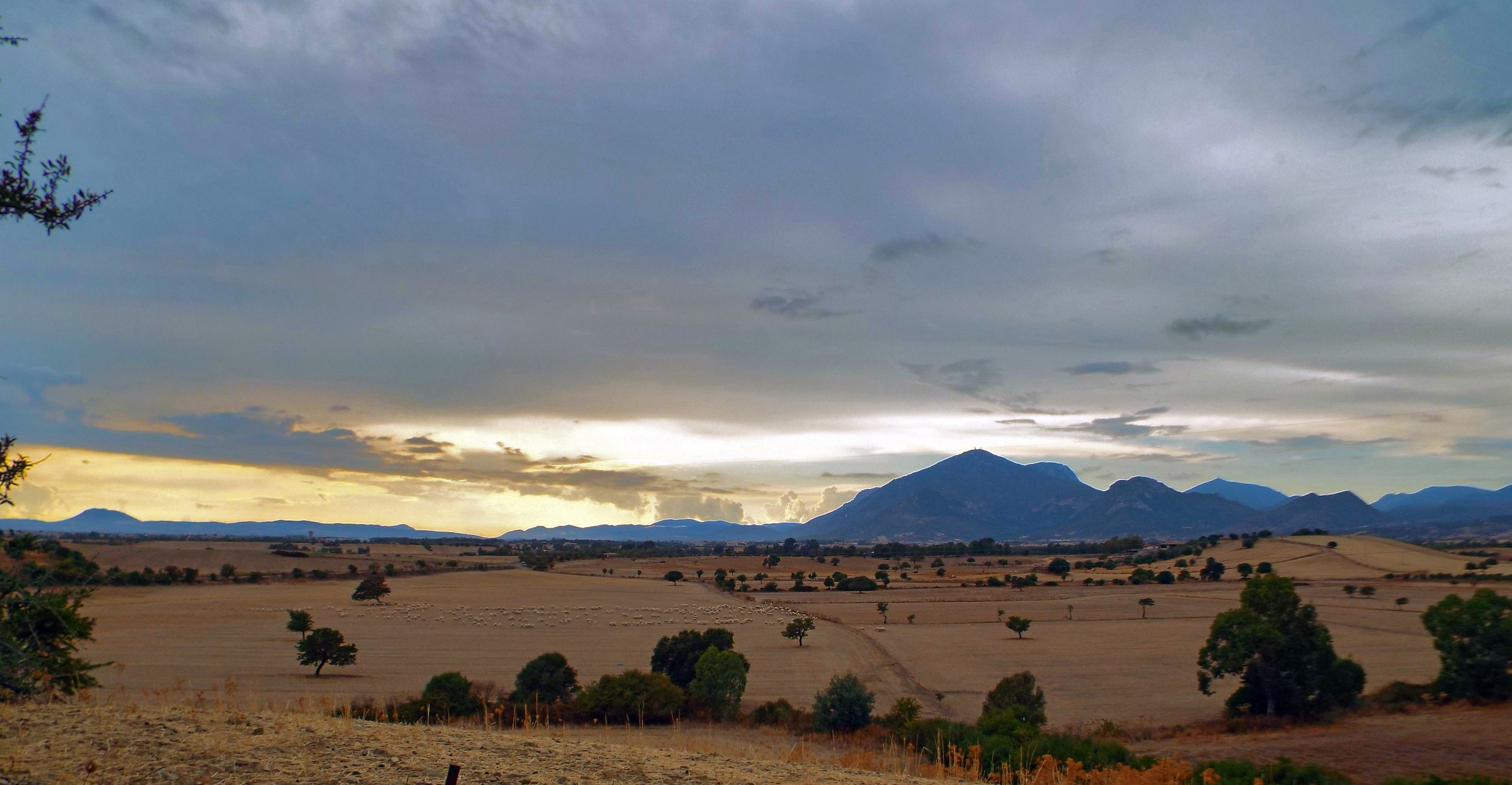
Berchidda
It lies on the southern slopes of Mount Limbara, the 'mountainous heart' of Gallura, that surrounds it with granite rocks shaped by the weather, not far from Lake Coghinas. Berchidda is a village with three thousand inhabitants, with Neoclassical and Art Nouveau houses and buildings positioned in a 'crescent' shape in steep streets. In the centre, you will find the parish church of San Sebastiano, with its wooden Baroque altar, and the seventeenth-century church of the Rosary. From the main square, you can enjoy a breathtaking view of the valley and Mount Acuto, an elevation that gives a name to the territory. On the occasion of Time in Jazz, which lasts for a week, around the 15 August Ferragosto holiday, the village puts on its best clothes, the squares become a theatre, the streets come to life with the colours and sounds of the nighttime concerts, starring the famous trumpet player, Paolo Fresu and musicians from all over the world.
By day, the rural churches of Santa Caterina and Sant'Andrea (seventeenth century), as well as the garden of the butterflies on Mount Limbara are settings in which the musicians improvise, inspired by the silence and beauty of nature. Berchidda's fame grew throughout the world at the same speed as Fresu and the international festival, which has been the key event of the island's jazz circuit.
Near the village, at an altitude of 500 metres, you will find the castle of Montacuto, built in the 11th century, a political and military centre and witness to the local medieval events taking place: it belonged to the Judges of Torres and those of Arborea, was the object of a dispute between Pisa and Genoa and, in the end, fell under Catalan rule. The remains of walls, a tower and a cistern still remain. The territory is rich in evidence from prehistoric times: tafoni and inhabited caves, Domus de Janas necropolises, dolmens, megalithic structures (Pedriscalas and S'Iscala Serrada), tombs of Giants and nuraghi. There are numerous Roman traces: Republican coins, the remains of the Olbia-Turris Libisonis and a bridge along the Silvani river. The road and fortifications of Su Casteddu indicate that this was once a transit area disputed between the "Romanized" and rebellious populations (the Balares).
The village is surrounded by the colours and fragrances of centuries-old oaks and holm oaks, brooks and little waterfalls, like that of Su Pisciale. The territory is populated by deer, fallow deer and mouflons, while northern goshawks and Eurasian sparrow hawks fly overhead. Then there are the vineyards: Vermentino di Gallura is produced here and is the only Sardinian wine with a DOCG (controlled and guaranteed designation of origin) label. The wine museum is located at the foot of the hill of Sant'Alvara and it retraces the history of grape-growing in Sardinia. Associated with it, is the regional wine shop, where wine tasting takes place and wine is sold. The wines from the local wine cellars accompany a unique culinary experience: things you should absolutely taste are sospiri, almond cakes, and suppa cuatta, 'flat breads' in sheepmeat broth, fresh and mature pecorino cheese. Other delicacies are maccarones furriados and sas laldadinas, filled pasta parcels. The economy is also based on cork processing and on breeding, to which the sheep festival is dedicated, taking place in May. Eagerly anticipated events are the rural festivals of San Marco (25 April), San Michele (mid-May) and Santa Caterina (beginning of June), where you can discover authentic flavours (cured meats, cheeses, cakes and pastries) and admire splendid traditional clothes.
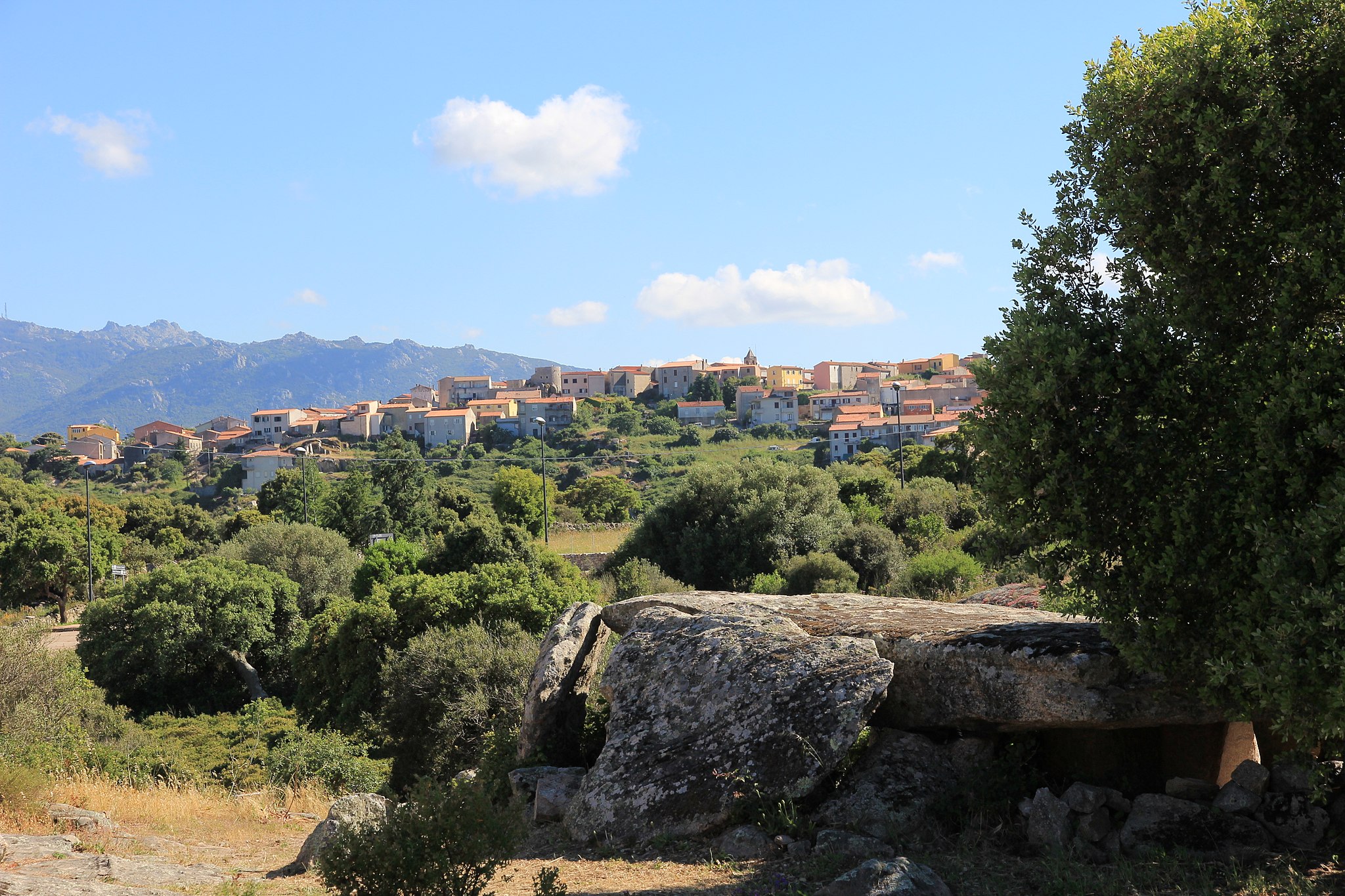
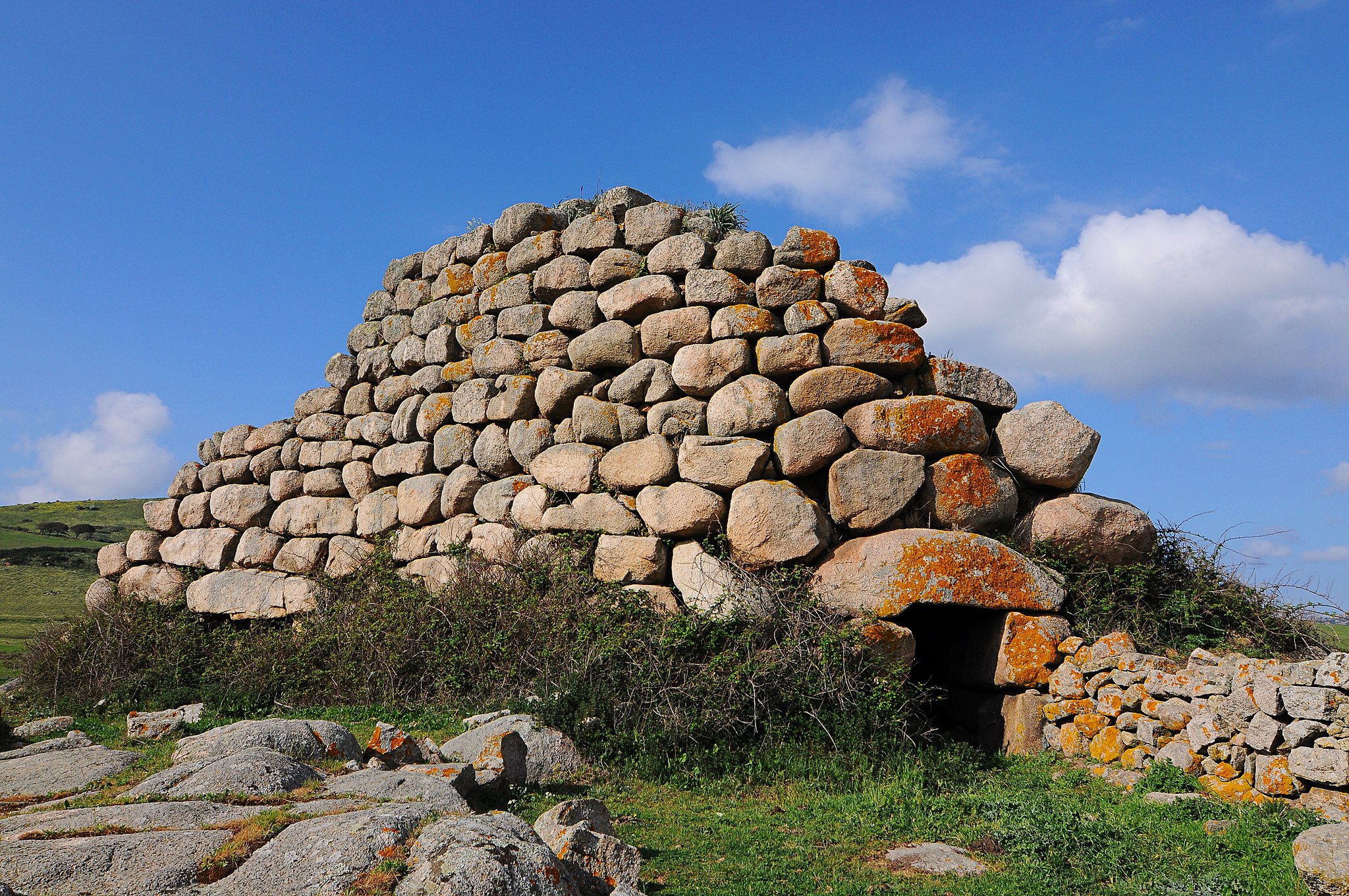
Luras
Luras is the home of the dolmen: of an original 78, four of the remaining intact examples on the island are here. This town of 2500 inhabitants is set 500 metres above sea level on a granite bedrock to the far north-eastern side of Mount Limbara. Despite being well within the Gallura region, locals speak the Logudorese dialect. There are two theories about the town's origins: founded as an Etruscan colony, or by the Jews deported by Emperor Tiberius (19 AD). From the Middle Ages to the 18th century it was known as Villa Lauras, and it reached peak splendour in the mid-19th century, thanks to trade, agriculture and sheep-farming. Today, the economy is based on agriculture and craft trades, in particular cork, granite and the production of vermentino and nebiolo wine.
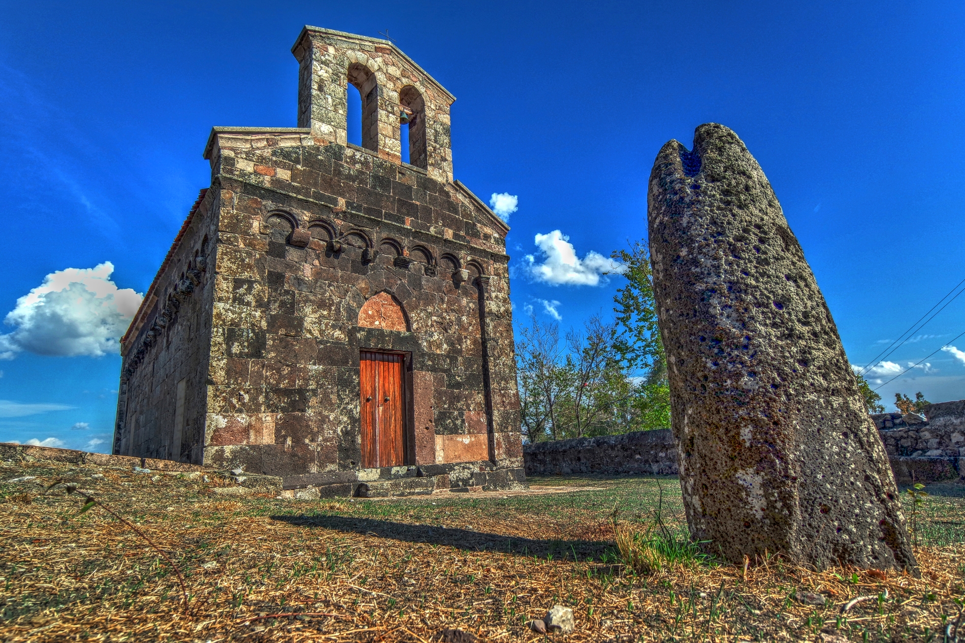
The area has been inhabited since prehistoric times. The Bronze Age left the remains of six nuraghes, while the four dolmens (or allée couverte) found near the town date from the pre-nuraghic period, 3500-2700 BC, and can be compared to similar Basque, Catalan, French, Corsican and Balearic Island collective burials (and places of worship). The townsfolk called them sepulteras de zigantes or de paladinos, in the belief that the enormous rocks used to build them could not have been brought by "normal" men, but only by giants. The Ladas dolmen is a tunnel six metres long and two metres high, covered by slabs and with an apse. The stone at the back has a surface area of 15 square metres. The Ciuledda dolmen is similar but on a reduced scale and with a semi-circular layout, while the Alzoledda and Billella ones are rectangular, with a trapezoidal chamber.
In the middle of the town is the parish church of Nostra Signora del Rosario (18th century), which holds three valuable paintings: the Vergine del Rosario (17th century), Pentecoste (1874) and Anime Purganti (1927), as well as two marble lions. Opposite the parish church, is the small church of Santa Croce (1677), where the brotherhood responsible for the Holy Week rites and the living nativity scene in traditional costume at Christmas is based. Next to it is the home of artist Tonino Forteleoni, where his works in cork are on display. Nearby, a typical granite home hosts the Galluras museum, an expression of ancient local culture: 5000 remains from the 15th to 20th century are on display, including the macabre hammer used by s'accabadora for ante litteram euthanasia. The town also has the churches of San Pietro (17th century) and Purgatorio (18th century). Rural churches include San Bartolomeo di Karana, which is next to the s'ozzastru, a wild olive tree that has a circumference of 12 metres, and which is estimated to be more than 3000 years old, making it one of the oldest in Europe. It is a natural monument and is on the list of the oldest trees in Italy. Together with "younger" trees, it overlooks the shores of Lake Liscia, whose waters reflect the surrounding granite mountains. The Trenino Verde railway passes right by this natural spectacle, stopping at Luras.
San Lorenzo - Silanus
It is only seemingly simple, with a single nave, typical Romanesque decorations and a bell gable. In reality, it contains ancient paintings and unusual decorations, as well as religious symbols from a Nuragic tomb. The church of San Lorenzo stands on a small hill in the northwestern outskirts of Silanus, surrounded by a tree-lined courtyard. It was built around 1150, probably by the Cistercian monks from the abbey of Santa Maria di Corte in Sindia.
The building has a single nave with a rectangular layout and a semicircular apse facing east. Inside it, there are traces of frescoes created around the first half of the 13th century, with images of saints and bishops. The portrayal of Saint Christopher, with his legs immersed in a river, stands out. You will also be surprised by the animal, plant and human-faced figures that appear in the hanging arches running along the perimeter of the church.
On the façade, you will see a portal, above which there is an architrave with a pointed relieving arch. The façade is divided horizontally by a ledge that delimits the pediment. Above it, there is a bell gable with two openings, while between the corner pilasters there is a series of double-ring arches, resting on corbels sculpted with different motifs. On the sixth one, you will notice the head of a bull. The roof is trussed, while the lighting is provided by single-lancet windows with embrasures on the sides and by a cross-shaped window just above the apse.
The church comes alive in the first half of August with the festival in honour of the saint to whom the church is dedicated, preceded by a novena during which gosos, heart rending devotional songs, are sung. The procession is preceded by the bandelas, horsemen with banners, followed by a parade in traditional dress with groups from all over the Island. There is no shortage of music, dance and evenings dedicated to poetry.
In the garden around the sanctuary there are five baetyls. For a long time, it was thought that they came from the Giants’ Tomb of s’Abbaia, not far from the nuraghe Corbos; now, however, there is a shared opinion that the origin should be sought in the Nuragic tomb of sa Pedra Longa. The baetyls have male and female characteristics and it is thought that they represent deities that protect the deceased.
Silanus is an open-air archaeological museum: in its territory there are about fifteen Giants’ Tombs, almost thirty 30 nuraghi, Domus de Janas and su Cherchizzu, which is one of the smallest well temples. Nearby, there is the captivating complex of Santa Sabina, with a church, of Byzantine origin, in front of the nuraghe of the same name. Not far away, there are two Giants’ Tombs. Further significant evidence of the Bronze Age is the nuraghe Orolio (or Madrone). Only the keep still remains, where you can still see the perfectly-preserved tholos roof of the rooms.
Sos Aranzos
Sos Aranzos is found at Sos Aranzos, in the commune of Golfo Aranci. The shore has fine white sand with rocky granite outcrops and wonderful cliffs. The isolated Sos Aranzos beach is one of the most suggestive of the Golfo Aranci coastline, with a view over the Island of Tavolara and Capo Figaro, with its shining extremely fine sand that contrasts with the variegated colours of the water, from green to turquoise blue. It is one of the most popular corners in this area. The little bay set among the cliffs represents a quiet peaceful oasis for the lovers of isolated and secluded gorges. According to an old tradition the name of the beach is linked to the so called “balls” of posidonia formed b y the sea and deposited along the shore.
Musei
Its water-rich territory extends in the valley of the Cixerri River and is irrigated by the river’s many tributaries which are in turn fed by the springs of the nearby Mount Domosnovas. Musei is a town of over 1500 inhabitants easily reached from SS130, which links Iglesias and Cagliari. The origins of its curious name are shrouded in mystery. Listed as Musej in Pisan income records (1323) and as Musey in the Codex Diplomaticus Sardiniae (a few years later). Later, from the Medieval period up to the 17th century, it was called Villa di Prato. During this period, it first belonged to the Giudicato of Calari and then to the Pisan Della Gherardesca family. The family were once the masters of the Acquafredda Castle, which stands in Siliqua, in the centre of the valley. With the arrival of the Jesuits, the name changed once more. The new name may have originated from the name Iesum read backwards, or the corruption of moisè, a Jewish settlement found here, or from the Semitic word mosià (task). In fact, it was the Society of Jesus to inherit the town in 1607 from feudatory (and protector of the Jesuits) Monserrato, the son of Elena Nicolau and a well-known humanitarian and judge of the Royal Audience. They played a crucial role in the development of the new town, overseeing the construction of a late-baroque church supplied with fine implements, including a silver-laminated processional cross, and the Convent of Sant’Ignazio di Loyola, patron saint of the Society of Jesus, whose feast is at the end of June. Residential buildings were constructed in the surrounding area. In addition to apostolate and cultural activities, the Jesuits gave a new impulse to agriculture, especially the planting of wheat and grapevines, as well as to livestock farming, for which the town became known throughout the island in the 18th century. This is the source of the strong agro-pastural traditions of present day Musei.
Fertile land has always drawn people to this area. Evidence of human presence in the area in ancient times includes nuraghes as well as Punic and Roman relics, especially a site near the extremely of village of Arruinalis, where the foundations of antient buildings have been excavated.

Sinnai
It lies on the hills that delimit the southern part of Campidano: from its location, the landscape reaches as far as the Golfo degli Angeli to the south and to the oasis of Sette Fratelli to the northeast. Sinnai is a town with 17 thousand inhabitants in the metropolitan area of Cagliari, historically founded on agricultural and pastoral activities and today on industry and on the tertiary sector. The olive-growing and wine-making and honey production are all still alive. The artisan tradition is focused on weaving reeds to make baskets and also on processing gold filigree, resulting in is prendas, splendid jewels. Women's dresses in precious fabrics are artistic: women’s mastery made them into works of art.
The vast and varied territory of Sinnai extends to the sea, from a portion of the splendid Torre delle Stelle to the tourist village of Solanas, more than thirty kilometres from the town, along the scenic road that leads to Villasimius. In Solanas, a long, wide beach of soft, golden sand is washed by waters reflecting every shade of green and blue.
The hinterland also offers evocative natural landscapes. Since the beginning of the 20th century, the Sinnai pine forest has represented a 'green lung' of conifers and a place for walks and recreation. The Park of Sette Fratelli-Mount Genis is spectacular, with its peaks of Sa Ceraxa and Serpeddì, which exceed one thousand metres in height. In the forests of Mont'e Paulis, Minniminni and near the lake of Corongiu, there are holm oaks, cork oaks, wild olive trees, phillyrea, juniper and mastics. Following well-marked out trekking and mountain bike itineraries, you may encounter fawns and weasels and see the flight of the golden eagle and the peregrine falcon. In the park, you will be able to visit the museum of the Sardinian deer in Campuomu.
The old town centre features narrow lanes, Campidano houses and prestigious buildings, featuring the Palazzo Civico (1860) and the ancient barracks of the Cavalleggeri cavalry, where the Sinnai Museum is currently located. Inside it, there is the art gallery with pictorial works from the 16th century to the contemporary age and the archaeological section, which 'tells' the story of the events that took place from the Neolithic era to the Middle Ages. You will discover artefacts from the Nuraghe di Santa Itroxia, from the little Nuragic temple of Bruncu Mogumu and evidence of the Phoenician-Punic period, among which the little statue of the god, Bes. The churches represent a precious architectural heritage. In the town and the surrounding area, the former parish church of Santa Vittoria, mentioned in a document dated 1141, and the current parish church of Santa Barbara Vergine in Gothic-Aragonese style. Inside it, there is a real museum of art, including altars and baptismal fonts made of marble, paintings, wooden statues and silver artefacts. In the districts, you will find the Romanesque church of Santa Barbara di Solanas and that of San Gregorio.
Narcao
It is famous for the mining village of Rosas, an example of industrial archaeology becoming a tourist attraction, and for the Narcao Blues festival, one of the main Sardinian musical events. Narcao is a village in the Lower Sulcis region with over three thousand inhabitants. Its undulating territory stretches between mountains shaped like 'jars' covered in Mediterranean scrub, oak trees, pinewoods and eucalyptus woods. A visit to the cave of su Bacculu is a must, where you can admire evocative flowstones and stalactites. These caverns were the stage of the first settlements in the territory, dating back to the Neolithic period: the relics found in the cave of su Maiu are now kept at the national archaeological museum in Cagliari. The landscape is dotted with the ruins of prehistoric residential building, dolmens and menhirs, as well as pieces of obsidian.
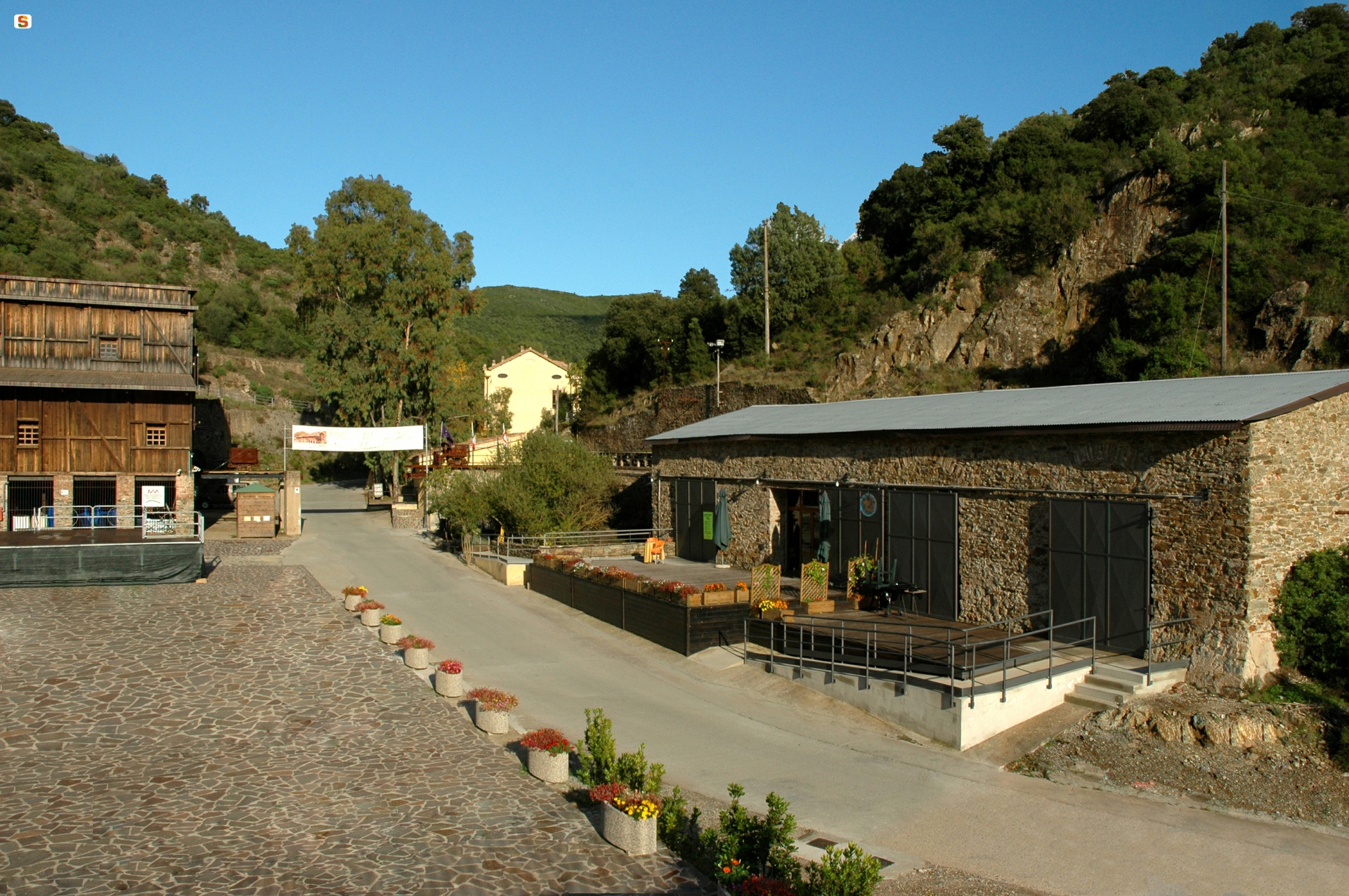
The large protonuraghe Atzei, which has a 'corridor' structure, dates back to the Early Bronze Age. In the Terraseo district, you will notice the ruins of a Punic temple dedicated to Demetra and Kore: small statues depicting the goddess were found in an altar. Roman tombs were found at Ollastra Frogheri. Benedictine monks were the first to occupy the fertile countryside of Narcao around the year 1000: they built the bell tower of the parish church of San Nicolò, patron saint celebrated in mid-August. The village flourished until the 14th century, after which it became depopulated. At the end of the 17th century, rural workers and shepherds settled there: symbolising the comparison with these settlements is the medau or furriadroxiu (small rural agglomerate) of Is Meddas, a hamlet of the village, which conserves its original structure - a central courtyard overlooked by low-rising farmhouses and a little landowner's edifice. The rustic dwellings continued to increase until the present-day village was formed, featuring houses made of unbaked bricks and decorated with murals representing scenes of life in the mines. Unsurprisingly, Narcao was the protagonist of the mining activities in the Sulcis region: the territory is dotted with abandoned mines, among which Rosas, surrounded by the Terrubia mountains and included in the Geomineral park of Sardinia: between 1851 and 1978, lead, copper and zinc were extracted here. Buildings and structures were renovated and transformed into an 'open air' museum-park, set in an unspoilt landscape with trails for trekking, mountain bike and horseback riding. In the square used as the washing area, the heart of the village, you can admire the former post office and headquarters (now a restaurant), the bakery and storage depots, the forge (now a bar), guest quarters and miners' dwellings, which were transformed into a holiday-house. As a whole, the Rosas park is an engineering and anthropological exhibition: it includes tunnels, 'shafts' and mills (still functioning) used for processing the minerals, documenting the technological development that took place. The multimedia rooms with illustrative panels and tools trace back the mining period and the miners' voices tell the story of the work and life conditions of the workers and their families. The village is also famous on an artistic level: since 1991, Narcao Blues, a very popular national music festival has been taking place at the end of July, with the participation of world-famous performers.
Nuraghe Izzana
Once you arrive in the heart of the vast Piana dei Grandi Sassi (Plain of the Big Stones), also called Valle della Luna (Valley of the Moon), surrounded by large granite boulders featuring anthropomorphic shapes, you will see an impressive tower rising up before your eyes, made of huge, roughly-hewn granite blocks positioned in irregular rows. It is the majestic Nuraghe Izzana, probably the largest Nuragic building in the whole of Gallura, on the border between the territories of Tempio Pausania and Aggius. From its summit, you can admire a wonderful 360-degree view: you’ll be struck by the wild beauty of the nature all around you. Here, the erosion caused by water and wind has dug out and shaped small and large cavities, such as caves and tafoni.
The grandeur and complexity of the Izzana brings to mind another building in Alta Gallura, the Nuraghe Majori, which stands near the present-day town of Tempio. They have the typical characteristics of the primordial ‘corridor-type’ nuraghi in common, which also differentiates them from many other more recent Nuragic structures. In fact, the Nuraghe Izzana dates back to between the end of the Early Bronze Age, at the beginning of the ‘stone tower’ civilisation, and the Final Bronze Age. The building has an oblong triangular shape with rounded corners. The chamber of the central tower has a tholos roof and is still intact, while the lateral ones, positioned at different heights from the ground, are now partially damaged but can be reached thanks to a series of internal corridors that run around the building. Two corridors branch off from the central chamber and one leads to four small cells arranged symmetrically.
One of the unusual features of the building is that it has various entrances: one in the south-east wall, leading into a short-splayed passageway covered by a jack arch that, in turn, leads to the chamber with a tholos roof. The second and main entrance is located in the south-west wall, built out of large well-worked stones, like the whole southern part of the nuraghe, and is the most recent. The entrance leads into a long corridor with an angular roof that, after a narrowing, leads you to the central chamber, which has a five-metre diameter and was built using rounded blocks that ‘rise’ in even rows up to the ogival closure. A flight of steps, now collapsed, led into a corridor with openings towards two other corridors. The first, longer one stretches diagonally, while the second slightly splayed one leads into a small uneven cell. On the left wall of the small room, you will notice the opening of another curved room. Another entrance to a straight corridor will take you out of the building through a narrow tunnel. The labyrinth-type layout has led some scholars to speak of a ‘nuraghe-trap’, built this way to confuse assailants. The unusual construction technique used and the uniqueness of the layout indicate that the construction is much more likely to be the result of several interventions that took place over time, the most recent of which may have modified and extended the initial buildings.

Cala Sassari
Secluded and with a wild appearance, thanks to the surrounding scenery, Cala Sassari will surprise you with the colours that the sea, sand and cliffs take on in the sunlight. The beach is about 500 metres long, with mixed golden and whitish-coloured grains of sand with some hints of brown. The bay is surrounded by Mediterranean scrub, which also covers the rocky peaks that surround it, giving the sea reflections of emerald green and turquoise. The transparent waters reveal a sandy seabed sloping gently towards the open sea and are shallow near the shoreline, allowing children to swim and play peacefully and the whole family to enjoy some relaxation. The beach is well sheltered from the wind and offers various services: parking, bars and restaurants, deckchair, beach umbrella and boat rentals and services linked to accessibility.
Cala Sassari is a destination for diving, snorkelling and underwater fishing enthusiasts, but it is also an ideal destination for enjoying splendid views: in front of you, you will see an islet known as Punta Pedrosa, from the name of the promontory to the south; further in the distance, you will see the majestic profile of the island of Tavolara, while looking north, you’ll see the village of Golfo Aranci and the islet of Figarolo.
You can easily reach the beach by following provincial road SP 82 between Olbia and Golfo Aranci and taking the well-signposted exit heading east. The surroundings offer countless other coastal treasures... the area of Golfo Aranci alone has more than twenty beaches. On the sides of Cala Sassari, in addition to the little cove of Punta Pedrosa, you will also find the Spiaggia Bianca (White Beach); to the south you will find the small Sos Aranzos, with white sand and a transparent sea. Near the town, lie the Cinque Spiagge (Five Beaches) one after the other, perfect for a holiday filled with relaxation and fun, thanks to all the services and convenience. If you are looking for wild coves surrounded by uncontaminated nature, you can head towards Capo Figari and explore the other ‘Aranci’ pearls: Cala Sabina, Cala Moresca and Cala del Sonno.

Sa Corona Arrubia
The ‘Corona Rossa’ (Red Crown) is a basalt plateau, in the countryside of Collinas and Lunamatrona, covered in red lichens, highlighted by the sunset. Here, there is a singular museum, which is both a scientific hub and a cultural centre, able to welcome hundreds of thousands of visitors since its creation, with permanent exhibitions, organised in three pavilions - wildlife, botanical and anthropic - and international-level temporary exhibitions, among which ‘Dinosaurs’', ‘The Great Spanish Painters’, ‘Leonardo da Vinci’ and ‘Ancient Egypt’.
In the wildlife section, you can admire the largest and most complete display of dioramas in Sardinia: eight life-size three-dimensional reconstructions of local spaces populated by local plant and wildlife. You will see the ecosystems of the ‘giare’, holm oak woods, riparian environments and arid pastures. The botanical section is in turn divided into a fungarium, a xylotheque and an herbarium: you can enjoy a 360-degree exploration of the plant world. The showcases emanate a particular charm with a description of the use of medicinal plants over the centuries and panels with accurate descriptions of the mushrooms.
The anthropic pavilion contains an archaeological and an anthropological section. At the entrance, you will see the life-size reconstruction of a pre-Nuragic hut. Continuing with the visit, you can admire stone reconstructions of Nuragic monuments: polylobed fortresses, Tombs of Giants and sacred wells. During the excursus you will be aided by a comparative table of time, which compares the general prehistoric and protohistoric eras to the Sardinian eras, with evidence of the main events. The ‘anthropological’ rooms, on the other hand, show a ‘cross-section’ of rural life in Marmilla in the first half of the 20th century, through the eyes of the inhabitants of that period.
Owned by sa Corona Arrubia, currently organised in a travelling exhibition, there is also a collection of 200 traditional hand-made toys. The museum also periodically hosts conferences on scientific and cultural topics, presentations, art exhibitions and musical events. Outside, you can follow educational paths in the geobotanical park, where Mediterranean plant species are grown.
In addition to indicating the plateau on which the museum stands, Sa Corona Arrubia also gives a name to the consortium of 18 Municipalities of Marmilla, formed to promote the enhancement of local cultural heritage. The organisation is dedicated to Giovanni Pusceddu, historic mayor of Villanovaforru, one of the main promoters of the initiative.
As well as seeing the full-scale Nuragic replicas in the museum, in its surroundings you can also admire ‘authentic’ archaeological evidence: in Lunamatrona, there is su Cuaddu de Nixias, the most ancient Tomb of Giants discovered, and the protonuraghe Trobas; in Villanovaforru, there is the nuraghe Genna Maria and the Civic Archaeological Museum; in Collinas, there is the nuraghe Concali and the tomb of sa Sedda de sa Caudela.