

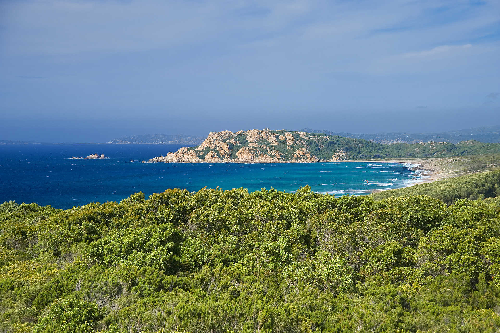
Supramonte di Orgosolo
The Supramonte is a mountainous complex characterised by carbonatic highlands and dolines. With an area of around 35,000 hectares, it also takes in the long stretch of coastline of the Golfo di Orosei and it falls within in the territorial areas of the municipalities of Oliena, Orgosolo, Urzulei, Dorgali and Baunei. Enormous rocky bastions characterize the landscape, alternating with deep canyons and rocky peaks that tower into the sky. The Supramonte, for ease, is divided according to the territories of the municipal areas in which it falls. The Supramonte of Orgosolo stretches from Funtana Bona to the calcareous Monte Fumai (1316 m), to Monte Novo San Giovanni, one of the most panoramic areas in Sardinia. This area of the Supramonte is characterised by grandiose karstic phenomena. The doline of Su Sercone, a wide calcareous abyss around 200 m deep, within which grow centuries-old yews is certainly worthy of attention. Another remarkable beauty is the forest of Sas Baddes-Nuraghe Mereu, considered to be the only extended area of holm oak forest in Europe, having never been felled.
Aglientu
Aglientu is located a few kilometres from the sea, in an area predominantly rich in granite. Its landscape is characterised by majestic boulders and green valleys that slope down towards sandy shores with high desert-like dunes alternating with imposing cliffs. Just like Monti Russu, a pink granite relief with a rounded shape extends towards the Gulf of Asinara. The 22-kilometre-long coastline, with extensive unspoilt stretches, is renowned for the beautiful beaches. Amongst the largest is Rena Majore (on the border of the Santa Teresa Gallura territory), Litarroni and Vignola, a fishing village where a Spanish tower from 1606 stands 12 metres high, from which a panoramic view of the sea and inland can be enjoyed.
The name of the town has Latin roots, with the meaning of white, also being present in other place names in the area (Montagliu, Agliacana, Frati Agli and Agliu). The discovery of stone tools dates the presence of man here since the ancient Neolithic period. Numerous Nuraghes, including Tuttusoni and Finucchjaglia, are mainly distributed along the coast. In Roman times within the area, at the height of the current Aglientu, there was a horse exchange station along the road from Porto Torres to Santa Teresa Gallura. The town centre was built in 1776, when Vittorio Amedeo III ordered the construction of the church of San Francesco d’Assisi. A few decades later, constructions went up in which religious ceremonies, socio-economic activities and trade fairs were held during festivities. Around 1850, a number of wealthy families built houses, establishing the first nucleus of Aglientu, originally a hamlet of Tempio Pausania, before becoming an independent municipality in 1959.
There are numerous town churches: the oldest is the 17th-century one dedicated to San Pancrazio (who is celebrated on 25th January), with much more recent constructions being those dedicated to San Giovanni and San Silverio in the Portobello marina (dating back to the decade of 1930-40). Even more modern, six kilometres from the town, is San Biagio, built in 1967 on the site of a previous edifice, inside which is safeguarded a wooden statue of the saint dating from the 15th to 16th centuries, carved by Sardinian craftsmen. Numerous summer festivals attract thousands of tourists from the coast: an event dedicated to seadas (a sweet cheese with honey) in late June, and to sausage and cheese in mid-August.
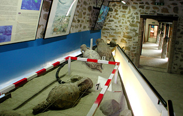
Modern and Contemporary Art Museum “Antonio Ortiz”
The museum is in the historic centre of Atzara, housed in a fully restored 19th-century building.
It occupies three floors and has three sections: a historic section, consisting of a photo gallery of the village in the early decades of the 20th century, an art gallery with works by foreign, Italian and Sardinian painters and, lastly, an area for temporary exhibitions.
One might wonder at the presence of a modern and contemporary art museum in a small village in the Nuoro countryside: its roots go back to the early 20th century, when Atzara was visited by three Spanish 'costrumbrist' painters: Eduardo Chicharro Agüera, Antonio Ortiz Echagüe and Bernardo De Quirós, drawn there by the local folk costumes and traditions. Atzara, which had already a vibrant intellectual and cultural life, thus became the centre of a local painting style, inspired by the Spanish example, attracting important Sardinian artists who spent time there. Some of the best-known names are Francesco Ciusa, Antonio Ballero, Giuseppe Biasi, Filippo Figari, Mario Delitala, Carmelo Floris and Stanis Dessy.
Besides featuring a notable collection of 20th-century paintings, the museum has an interesting group of contemporary paintings, donated by collectors, artists and public institutions. The best known work is certainly the painting by Antonio Ortiz Echagüe 'Donne di Sardegna', which the museum has on loan from the Regional Ethnographic Institute.
Address: piazza Ortiz Echagüe - 08030 Atzara Phone +39 0784 65508 Managing Agency: Municipality of Atzara.
Coacuaddus
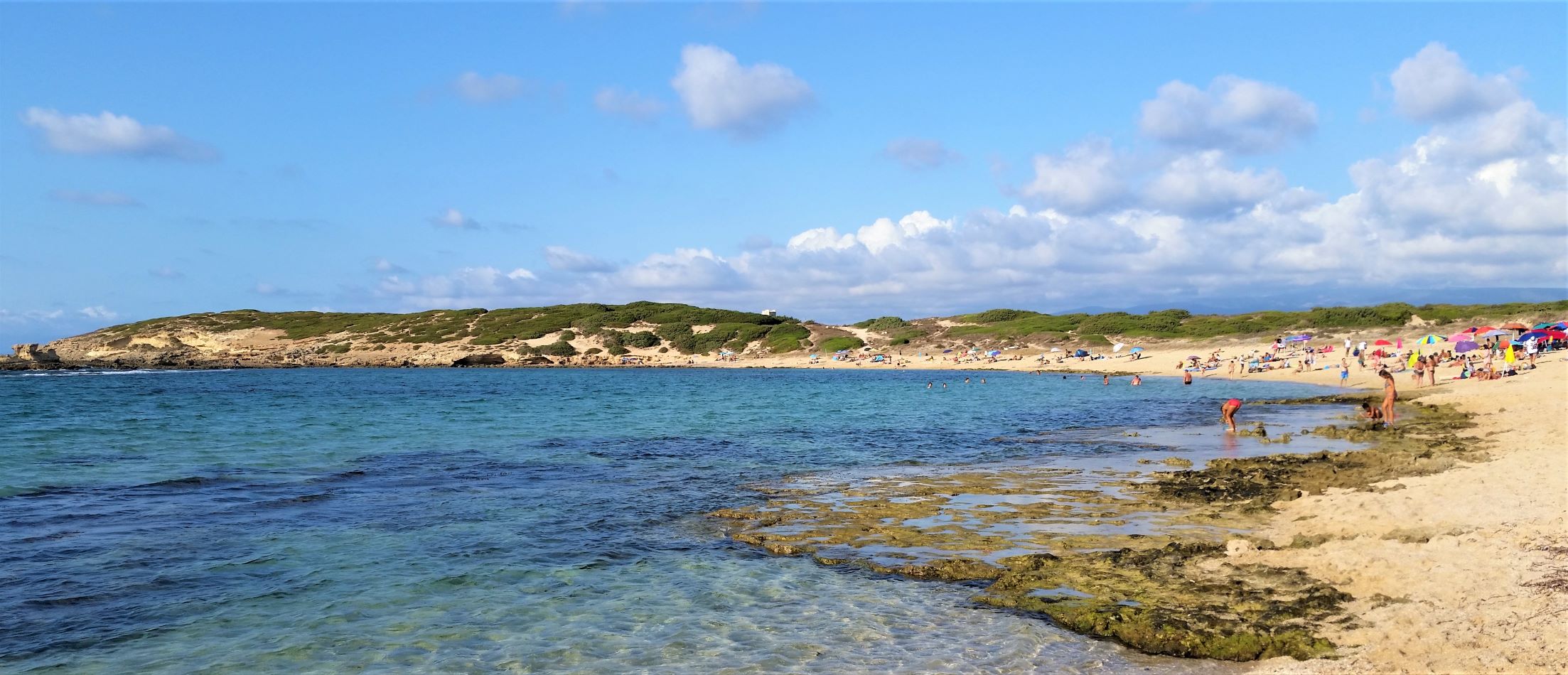
Its name means 'ponytail' and derives from the sinuosity of the coast with its numerous inlets. Coacuaddus is a long beach of white, coarse-grained sand, divided into two parts by a large rock and bordered by limestone cliffs. It is one of the pearls of the Island of Sant’Antioco, which will enchant you with the clarity and colours of the sea: the bay, thanks to the green hills that surround it, has turquoise and green hued waters. The sandy bottom remains shallow for several meters, making swimming easy and safe even for small children. You will have various services available, including ample parking and dining options.
From the sand towards the sea, the view opens onto the beautiful dunes of Porto Pino (in the territories of Teulada and Sant'Anna Arresi). Close to the rocks, the rich underwater life and the transparency of the water make for great snorkelling and scuba diving, and attract underwater fishing enthusiasts. The fields around let the scents Mediterranean plants waft gently over the beach. They are a destination for lovers of unspoiled nature, thanks to the proximity of the pool of Santa Caterina, where black-winged stilts and flamingos nest.
The beach is one of the pearls of the coastline of Sant'Antioco, where there are high cliffs of dark trachyte to the south and sandy shores to the north, including the beautiful Maladroxia. Do not miss the cliffs of is Praneddas (or arco 'dei Baci'), where you can stand on a terrace, 200 meters above the sea, to admire the whitewashed rocks of Cala Sapone and Cala Grotta and Cala della Signora. Capo Sperone is the farthest point to the south, with iridescent blue sea and expanses of pink peonies. Opposite lie the islets of Vacca and Toro, natural havens inhabited by rare birds. Portixeddu is the nearest beach to the village of Sant'Antioco, and is made of pebbles, like the nearby and larger Turri beach. Coacuaddus, on the other hand, is located about ten kilometres from the town, and is the main centre of the largest island of the Sulcis archipelago. The town is characterised by colourful houses, amazing restaurants and a tourist port, which give it a strong seafaring identity. Once it was known as Sulky, a Phoenician colony born in 770 BC, which later passed under Carthaginian rule and became a flourishing Roman city with the name of Sulci. Don't miss a visit to the sanctuary of Sant'Antioco Martire, patron saint of Sardinia, and to the Ferruccio Barreca archaeological museum which contains Phoenician-Punic finds.
Cala Capra
The beach of Cala Capra looks out onto the sea of a thousand blues of the Gallura region, at only 4 kilometres away from Palau, along the east coast of the small granite peninsula of Capo d'Orso, the rock that constitutes one of the most famous symbols of the Gallura. The sandy beach is quite wide and runs smoothly down into the sea, allowing children to play in safety.
Scivu
It is one of the most beautiful stretches along the Costa Verde, in the territory of Arbus, a village in the province of Medio Campidano. It is not easy to get to, which makes it even more enchanting, and is located in a setting in which nature is almost completely unspoilt, with no villages nearby. In Scivu, you will witness a deafening silence, interrupted only by the surf of the sea and the cries of the seagulls.
The beach, with its pale, soft sand, which seems to 'speak' as a result of the echo you can hear when you walk on it, is divided in two by a small cliff and is a paradise for enthusiasts of underwater fishing. To the sides and behind it, there are reddish rocks and soft dunes, dotted with mastic, broom, strawberry trees and juniper, which descend from the mountains to the sea. You will reach it after travelling along a panoramic road, taking the paths between the dunes or going for a walk along the shore.
The water is astonishingly transparent and its colour is dazzling when it is lit by the sun's reflections. The most seductive moment is sunset, when the sand and the rock faces turn red. The seabed is varied: gullies, sandbanks and a scattering of rocks - everything that snorkelling enthusiasts are looking for.
The beach has ample parking, at the nearby beach of Nuraci, which is also suitable for camper vans, and there is also a place for dining/refreshments and equipment rentals. The wind is often strong and, not surprisingly, it is the ideal destination for surfers. However, caution is needed, because the Costa Verde sea is spectacular and wild, but rarely calm. Furthermore, it is one of the most well-known hot spots for surf-casting enthusiasts: almost all of the species of Mediterranean fish can be found here.
The dunes are a distinctive feature of the entire Costa Verde: don't miss your chance to visit the Sabbie d'Oro inPistis, the magnificent Torre dei Corsari, the beautiful Funtanazza, Marina di Arbus and Portu Maga, the ‘desert’ of sand in Piscinas that, along with Scivu, is the real jewel of this coastline, and lastly Capo Pecora, a much-loved destination for divers and fishermen.
Poetto di Quartu Sant'Elena
The stretch of the Poetto beach belonging to the town of Quartu Sant'Elena, in itself several kilometres long, runs from its eastern end at Foxi westward where it joins the Poetto of Cagliari. It is a wide band of fine white sand, which continues into the seabed. It is backed by a row of palm trees and other plant life, some patches of which also extend onto the beach. On account of its environmental value, clean and transparent waters and range of facilities and services, the beach has been awarded the blue flag.
The Poetto of Quartu Sant'Elena is in the locality of the same name, in the Municipality of Quartu Sant'Elena, and is also easily reached from Cagliari.
Sa Mesa Longa
Set between the cliffs of Capo Mannu and the coast of su Pallosu, it owes its name to a natural sandstone barrier a few dozen metres from the shore that completely isolates it from the northwesterly “maestrale” waves, creating an authentic natural swimming pool. Sa Mesa Longa, ‘the long table’, one of the pearls of the marine area of the Sinis peninsula, is found in the locality of Putzu Idu, in the territory of San Vero Milis, twenty kilometres away: it is a beautiful, extremely long, varied and multicoloured beach, with ochre yellow soft, fine sand, a pinkish-red colour along the water’s edge made up of pebbles and shells and black rocks that cut the beach in two as it plunges into a sea that, depending on the light, reflects every shade of blue, with its shallow waters and sandy seabed.
In the middle of the bay and the huge natural pool, there is a small promontory that divides the beach into two parts, opposite the distinctive round-shaped islet, covered in vegetation, behind the dunes, while on the southern side, you can admire the cliffs of Capo Mannu. The unusual feature here is the natural ‘wall’, a few metres from the shore, which you can reach by swimming or, when there is low tide, by walking across flat rocks: when you climb up onto a rock emerging from the sea and you will feel as if you are walking on the water. Not surprisingly, sa Mesa Longa, with its exceptionally calm waters, is also called the Lagoon, a captivating and wild lagoon, greatly loved by surfers. There is ample parking at the beach, also accessible to camper vans, and a refreshment area.
To the north of the ‘table’ are the beach and the cat colony of su Pallosu and, beyond Capo Mannu, sa Rocca Tunda and the little coves of Scal’e Sali. To the south, at the base of the cliffs of the Capo, you will find the beaches of Mandriola, Putzu Idu and the splendid s’Arena Scoada.

Sa Capanna
The small inlet, bellow the old tower of Pozzo, which is accessed via a steep series of stone steps, is characterised by vocanic formations and opens out onto a wonderful view towards the locality of S'Archittu.
The sea here has characteristic blues and greens which surround this quiet beach and offers a most intense and evocative play of colour.
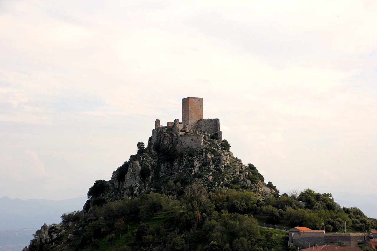
Museum of Sardinia’s Castles
In its rooms you can go on a journey through time, to medieval Sardinia with its fortresses, wars, treaties, intrigues and stories halfway between fantasy and reality that have survived to this day, with special focus on the events of the four Sardinian judicates of Calaris, Arborea, Torres and Gallura. The Museum of Sardinian Castles is located in the heart of Burgos, in the rooms of a late 19th-century manor house, which belonged to a family of local landowners. The building, which has been refurbished and renovated, has three floors. The museum itinerary is structured into various thematic spaces. One part contains temporary exhibitions on the subject of castles, another displays thematic maps that indicate the coastal towers of the Spanish era and the strategic defence points on the Island, constantly subjected to attacks due to its geographical position, in the centre of the Mediterranean trade and military routes.
There is also an area of the museum entirely dedicated to the reconstruction of rural life. You can deepen your knowledge of the work instruments from the past and of the tools of different shapes that illustrate man’s work and toil. In an area of the museum, there is an exhibition of old and recent photos on the subject of castles. The itinerary ends with a multimedia room that allows you to enjoy a historical reading of the approximately one hundred castles of Sardinia.
Walking a few hundred metres to the east, along a cobbled path, you will reach the Castle of Burgos, also known as the castle of Goceano. It stands in an isolated position on the top of a rocky massif, a position that helped make it practically unassailable. You can still see the fortress’s triple surrounding wall, the perimeter walls and the large tower, over fifteen metres high.
After the visit, it’s worth taking a walk around the narrow streets of the village, observing brick houses with gabled roofs and losing yourself in the medieval-looking alleys of the historic centre. A good way to relive the medieval atmosphere of Burgos is to participate in Prendas de Adelasia, a festival that takes place in December.