
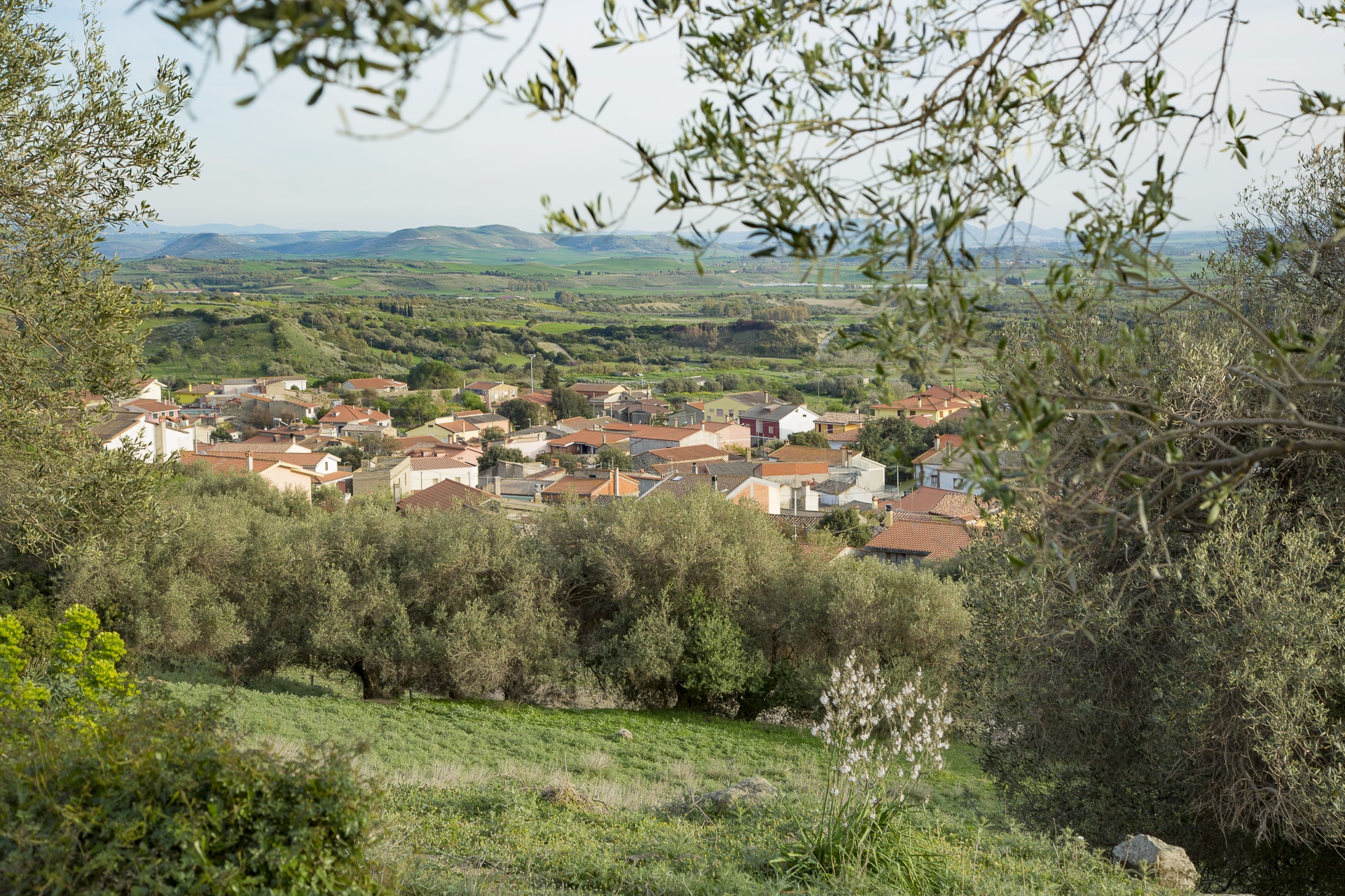
Sini
Dominated by the imposing but evocative silhouette of Giara Park, it peeks from between lush, rolling hills, from which visitors can enjoy a view over fascinating scenic cliffs covered with almond groves, vineyards, century-old olives and cereal fields. Sini is a small town of 500 inhabitants that lies in the portion of Marmilla belonging to the Province of Oristano, from which it is over 60 kilometres away. The place name derives from sinu, a reference to the cove where the town is located. During the Medieval period, the town was part of the Giudicato di Arborea, while during Aragonese rule it was first the property of the Baron of Tuili and then of Marquis Laconi.
The municipality of Sini includes part of Sa Jara Manna (the Giara), a basaltic plateau of volcanic origins home to wild horses unique to Sardinia. A wild and uncontaminated place that has no parallels, it is an ideal setting for hiking, biking and horseback riding. Another of Sini’s naturalistic jewels is the Park of Cracchera, embellished during less arid periods by the Su Strumpu waterfall.
In the town centre, stand the Parish of Santa Chiara d’Assisi, whose patron is celebrated in mid-August, and the ancient Church of San Giorgio Megalo. In late April, the town comes alive with a celebration in the patron saint’s honour marked by folklore events, craft exhibitions and above all, the Festival of Su Pani ‘e Saba. The festival, an opportunity to try this delicious sweet of almonds, raisins and sapa, attracts thousands of visitors every year.
The extremely fertile and welcoming lands surrounding Sini, which currently lives mainly of farming and shepherding, is dotted with prehistoric and Roman sites where tombs, pottery and coins have been found. Seven nuraghes can be visited: Bruncu su Sensu, Buccascala, Perdosu, Scala ‘e Brebeis, Sedda, Siorus and Bruncu Suergiu, on the Giara, near the border with Genoni. Around the latter, the remains of a Punic-Roman settlement can also be seen.
Civic Archaeological Museum “Giovanni Patroni”
The museum, housed in a period building in the historic centre of Pula, displays the finds from the ancient city of Nora and the surrounding area.
Nora started off as a Phoenician and then Punic seaport, and later became a Roman city. It was inhabited from the 7th century B.C. to the 8th A.D., when the Arab raids led its citizens to flee to the interior.
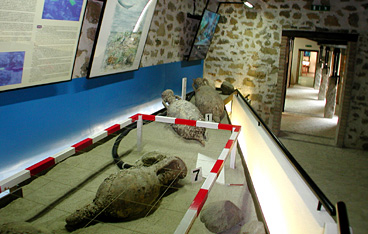
The Museum provides interesting insights into the colonisation of the area and the founding of Nora, the earliest city in Sardinia, and traces its life along the centuries, as told by daily use objects and by those concerning religious beliefs, rituals, and funerary rites. One section of the museum houses the steles of the Punic tophet, ranging from the 5th to the 3rd centuries B.C., accompanied by 19th-century photos of the excavation campaigns. Another interesting section has underwater finds: amphorae, anchors and Punic and Roman pottery.
This museum is an essential complement to the visit to the city of Nora.
The centrepiece of the collection is the gold foil with a 'gorgoneion' (Gorgon's head), which is also the museum's logo: it was found in a chamber tomb of the Punic necropolis in Nora.
Address: Corso Vittorio Emanuele, 67 - 09010 Pula Phone 070 9209610 Managing Agency: Municipality of Pula Manager: soc. coop. Tur, campeggio Cala d'Ostia - 09010 Pula Opening times: 9.00 - 20.00 (summer). 9.00 - 17.30 (winter). closed Mondays Tickets: &euro. 2.50 (full price). &euro. 2.00 (reduced price). Single ticket including visit to Nora: &euro. 5.50 (full price), &euro. 4.00 (reduced price for groups of more than 20 people), &euro. 2.50 (reduced price for children aged 6 to 14 years). Free entry for children under 5 years, and for reduced mobility persons with assistant. Guided tour service is included in the price of the ticket (booking recommended for groups and schools). The museum cooperates in school projects on archaeology and organises conferences on the excavation activity in Nora. The archaeological library can be used on request. Bookshop. Free brochures. Fully accessible to visitors with limited mobility. Tactile route with braille captions.
Ortacesus
It stretches in the lowlands north of Flumini Mannu which, along with three artificial streams flowing passed the town, has always maintained the fertility of its lands. Ortacesus is a small town of less than one thousand inhabitants in the centre of Trexenta. In ancient times, it was one of Rome’s granaries and remains a centre of cereal production (wheat and maize) to this day. The summer Wheat Festival, which focuses on traditions related to the harvest, and the Museum of Wheat year-round are proof of this. The museum is housed in the very old Casa Serra, the town’s traditional mansion. An extensive exhibit of artefacts and tools – including a rare wooden spring – illustrate traditions that have been passed down through the generations and ancient male (seeding, working the land and harvesting) and female (weaving, and bread baking) jobs. The museum also includes La Via del Pane (The Road of Bread), and unfired brick and culinary workshops followed by a tasting of typical dishes.
The town is also known for the cultivation of sugar beets, grapes and vegetables, as well as for traditional crafts, including embroidery of traditional clothes, weaving and production of musical instruments, such as the launeddas. A unique local peculiarity is a large ostrich farm, founded in 1997. The town was first mentioned in Medieval documents as Ozrokesus. Around the year 1000, it became Orzochesos, and then, with time, Ortechesus. The urban layout reflects the Trexenta tradition: straight streets and repeatedly intertwined alleys. In the city centre, the eye is drawn to the Parish of San Pietro, a Catalan Gothic church built between the end of the 16th and the beginning of the 17th centuries. It houses a notable wooded altar and statues of Madonna del Rosario and of various saints, dating to the 17th and 18th centuries. The Church of San Bartolomeo, built over an antient Roman pagan temple located about one kilometre from the town, is older yet (12th century). It is said that it was the church of the original Ortacesus village, before it was moved to its current location. Today, the residential area stands in an area with closely spaced settlements, along the transect between Senobi and Gausila, along which there are numerous mineral water springs, including Mitza s’Orrù, Mitza su Fenu and Bangius Fountain, already in use during the Roman period to supply baths. Roman ruins can also be seen by another spring, Sa Mitza Siddi. But, the earliest evidence of a human presence is prehistoric in age: several Bronze age nuraghe, including the famous S’Omu de S’Orcu at the border with Guasila.
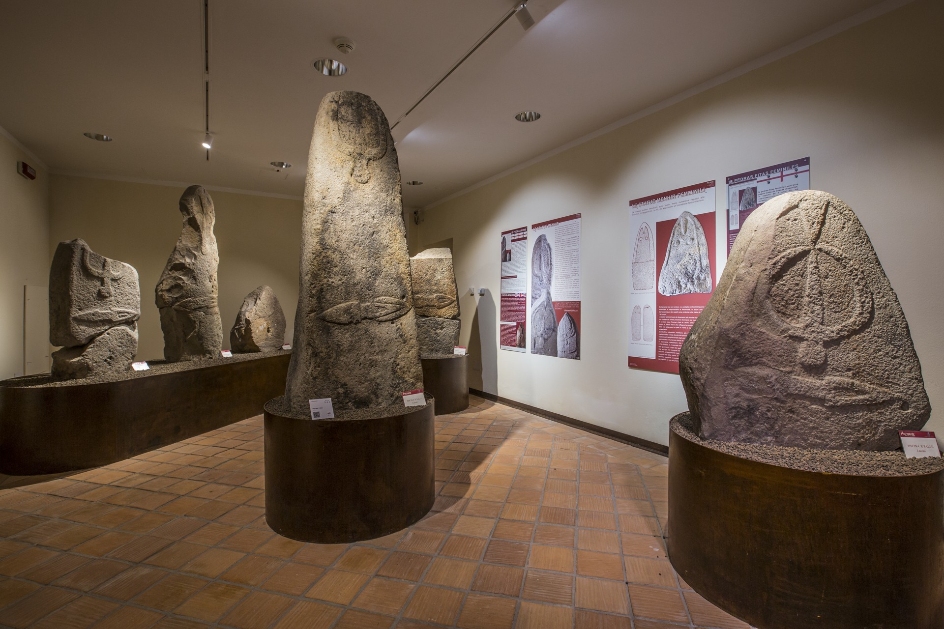
Menhir museum - Museum of prehistoric statuary in Sardinia
Fascinating and of great scientific value, the exhibition embellishes the village-jewel of Laconi. The museum of prehistoric statuary in Sardinia hosts a unique collection of 40 monoliths-menhirs (perdas fittas in Sardinian), a number of giants, attesting to the typological development of anthropomorphic statues in the 3rd millennium BC and accompanying visitors on a discovery of figurative and symbolic expressions of the first age of metals on the Island and in the European megalithic tradition. The museum itinerary unfurls over two floors of the 19th-century Aymerich building, a stately neoclassical home in the centre of the town. Ten rooms, with multimedia support devices and panels, are dedicated to prehistoric statues of Sarcidano and neighbouring territories. The eleventh room displays ceramic, metal and stone finds (from ancient Neolithic to ancient Bronze), coming from megalithic sites such as the Corte Noa dolmen and Masone Perdu tomb.
The 40 menhirs, carved in trachyte, are of three types: proto-anthropomorphic, of ogival shape and void of depictions, anthropomorphic ungendered figures, with somatic facial features, and statues-menhirs rich in details that distinguish the sex. The masculine ones have arched eyebrows and a pronounced nose, in addition to the symbolism of the ‘overturned’ (linked to the worship of the dead) and of the double dagger (a sign of strength and power). Perhaps they were statues dedicated to tribal chiefs or warriors who had performed marvellous deeds. The smaller female ones have conical or flat chests. In some cases, the hairstyle is noteworthy, such as in the Genna Palàu I statue. Quite particular is the statue Piscina ‘e Sali III, with a low relief under the bust that is the frame of a door, through which one enters into the world or has access to the otherworldly life, a motif attributable to the Mediterranean Mother Goddess. The most famous findings are those of Masone Perdu (an alignment of seven menhirs), Perda Iddocca (eight monoliths) and Pranu Maore (six statues). Other specimens of the museum, which are distinguished by an iconography differing from that of the Sarcidan menhirs, three coming from the site of Pranu Orisa in Allai, where there is a large multiform group, from Paule Lutùrru of Samugheo, where the site of Cuccuru e Lai has resulted in other very interesting fragments, and from the territory of Villa Sant’Antonio, a village famous for its statues-menhirs. After visiting the menhir museum, the Bandiere Arancione village of Laconi and the devotion of its community to Saint Ignatius - the house of his birth, museum of sacred art and parish dedicated to him (15th century) are all stops on an intense journey. To be surrounded amongst greenery, there is Parco Aymerich, a short distance from the centre. This garden of holm oaks and exotic plants is interspersed with caves, waterfalls and ponds, surrounding the remnants of an 11th-12th century castle.
Maraté - Museum of Copper and Textile Art
It is the only copper museum in Sardinia, but above all, it is a journey back in time to a world made up of workshops, ancient know-how, voices and sounds from streets, piazzas and artisanal workshops that made deeply symbolic luminous objects in cramped, dark, busy coppersmitheries, but also gorgeous tapestries made by the local weavers. These are the main artisanal traditions typical of Isili, a “bordertown” between southern Sardinia and Barbagie. This heritage is displayed in the rooms of Maraté, a museum dedicated to the art of coppersmithery and textiles housed in the 18th century Scopoli convent. The exhibit is made up of three sections, one for copper and two for the art of textiles.
The first illustrates how copper was traditionally worked and sold on the streets. You’ll see a typical cart loaded with new items and copper objects gathered to be smelted. In the reconstruction of a coppersmithery you’ll even see some of the original tools they used. The copper items are also displayed in keeping with how they were used at home, by peasants and shepherds, their social and aesthetic value, and as parts of a wedding trousseau, for example. The artistic section dedicated to textiles contains thirty tapestries, a synthesis of tradition, research and innovation. Informational panels document how the work is done, from the processing of the wool to its dying, including the use of copper, and gold and silver thread for lovely chromatic effects. A third section has been added to the museum and is dedicated to the ethnographic aspects of the weaving. The museum experience is further enhanced by a soundtrack of music, voices and audio effects that characterise each room, making it feel as though you are walking through the village and even hearing the “secret” jargon of the coppersmiths, s’arromaniscu or arbaresca.
Isili sits within a natural park with enchanting landscapes and archaeological treasures. You can go for a hike or cycle along the shore of San Sebastiano Lake, even do some fishing or canoeing. On an island in the middle of the lake is the little church of San Sebastiano. Just a kilometre outside of town is an example of one of Sardinia’s most elegant Nuragic architecture, is Paras. This nuraghe has a central tower and three secondary towers connected by a wall. The inner room has a false dome ceiling that reaches almost 12 metres, the tallest in all of Nuragic Sardinia.

Piscinas
Stretching along a plain surrounded by undulating hills, it shares its name with the torrent that crosses the territory and flows into the lake of Monte Pranu. Piscinas is a rural village with less than 900 inhabitants, located at the centre of the lower Sulcis mining basin, historically linked (and at one time, also administratively) to Giba, an autonomous municipality since 1988. Its main resources are the cultivation of artichokes, citrus groves, vineyards and sheep-breeding, as well as a bentonite factory. Its fame is also connected to the artisan production of Sardinian wickerwork.
The first human remnants in the territory date back to the ancient Neolithic period (VI millennium BC), found in the cave of Su Benazu, upstream of Miana and in the Tatinu rock. The Domus de Janas of Tuttui and Monte Medau date back to the end of the Neolithic period. Remains from the Bronze Age, which can be admired in the place of worship of Monte Sa Turri, in the fortifications of Monte Murrecci and in the Nuraghe Corongiu Longus, De Frois, Is Ulmus, Matas, Santa Lucia, Santus and S'Acqua Callenti, where there are thermal springs, today called Sa Cracchera, which were utilised in the 19th century and contributed to the development and renown of the town. Not to be missed are the Phoenician-Punic and Roman ruins, in particular the fortifications of Pani Loriga, built to defend the territory from Saracen raids, which gradually weakened the territory through to the early Middle Ages, when it was completely depopulated. After the year 1000, thanks to the work of a community of monks, a village was established on the site of the current one. During the domination of the Judicatus of Caralis and maritime republics, it was initially called Piscinae, then Pixinas. From 1337, passing to the Aragonese, it became the Villa (or ‘Salto’) di Piscinas. In 1538, it was subjected to enfeoffment by the Spanish patrician family of the Salazar, who held it for a long time and built Villa Salazar on what is today the centre of the town. The ancient noble residence was rebuilt in the late-19th century and renamed Villa Bice, designed by the engineer Giorgio Asproni Junior, nephew of the famous Sardinian deputy and scholar. Today, it can be visited amidst the greenery of a large local park. Alongside is the Piazza San Giorgio, with a beautiful mosaic depicting the saint battling a dragon, and the Chiesa di Nostra Signora della Neve.

Senorbì
Senorbì is the geographical and economic hub of Trexenta, a historically-rich territory, nicknamed the ‘granary of Rome’ in antiquity. A town of 5,000 inhabitants currently experiencing demographic growth - a rarity amongst the non-coastal Sardinian Municipalities - Senorbì thrives on the cultivation of sugar beets, wheat, olive groves and vineyards, being a commercial point of reference for the area. Its fertile territory encompasses hills and flat stretches, furrowed by tracks to be travelled by mountain bike or on horseback. The colours change with the agricultural cycle: the brown of the earth in autumn, the green of the wheat growing in spring, the blond expanses of crops during the summer. There is a great passion for horses that sees riders from all over southern Sardinia come for the feast of Santa Vitalia so as to compete at a trot during Is Cuaddus de Santa Vida, reaching the 19th-century Villa Aresu in the hamlet of Sisini.
Other manor houses embellish the historic centre, formed by a network of narrow streets overlooked by houses with a rural matrix. The parish church of Santa Barbara, the 17th-century church of San Sebastiano and the Chiesa di Santa Mariedda, built at the end of the 13th century as a sanctuary of Segolay, the main medieval Villa of Trexenta, complete the picture. On the façade are the neat rows of sandstone blocks of Roman ‘manufactory’. The festival in honour of the patron saint takes place at the beginning of August, preceded by a folklore festival at the end of July. Another 19th-century house has been set up as an archaeological museum: Sa Domu Nosta. Pre-Nuragic artefacts come from inhabited areas and necropolises. From the 3rd millennium BC, there is the famous Mediterranean mother goddess, the statuette found in Turriga (Selegas), as a testimony of the exchanges with the Aegean. The museum itinerary follows the Nuragic age. In the Senorbì countryside, the imposing Su Nuraxi in Sisini remain, with an unusual planimetry, similar to a holy well, part of the tower of the Nuraghe di Simieri and the remains of the tower of Monte Uda. The finding of a fundamental Nuragic structure is the Miles Cornutus, a bronze figure depicting a warrior with very high horns on the helmet, found near the town in 1841 and now held in the National Archaeological Museum of Cagliari. The arrival of the Carthaginians changed the area profoundly: acropolis and houses (perhaps also forging workshops) constitute the hill settlement of the Santu Teru (6th-3rd century BC), connected to the Monte Luna necropolis, comprised of 120 tombs, mostly of the well variety, as well some in pits, a selection of which are decorated in red ochre. The rich funerary objects confirm that it was a thriving town. Items include talc amulets, silica paste, metal, bone and glass, amphorae, jugs, perfume burners, cups, lamps, plates, coins, jewels and jewellery in gold, silver, bronze and iron (rings, bracelets, tiaras, earrings and necklaces generally). Artefacts of Egyptian inspiration and of Greek and Central-Italic importance have been determined. Together with the remains of a villa in Bangiu, Monte Luna also represented the most important hub of Roman times. It is hypothesised that the surviving inhabitants founded Senorbì.
Cala Sabina - Golfo Aranci
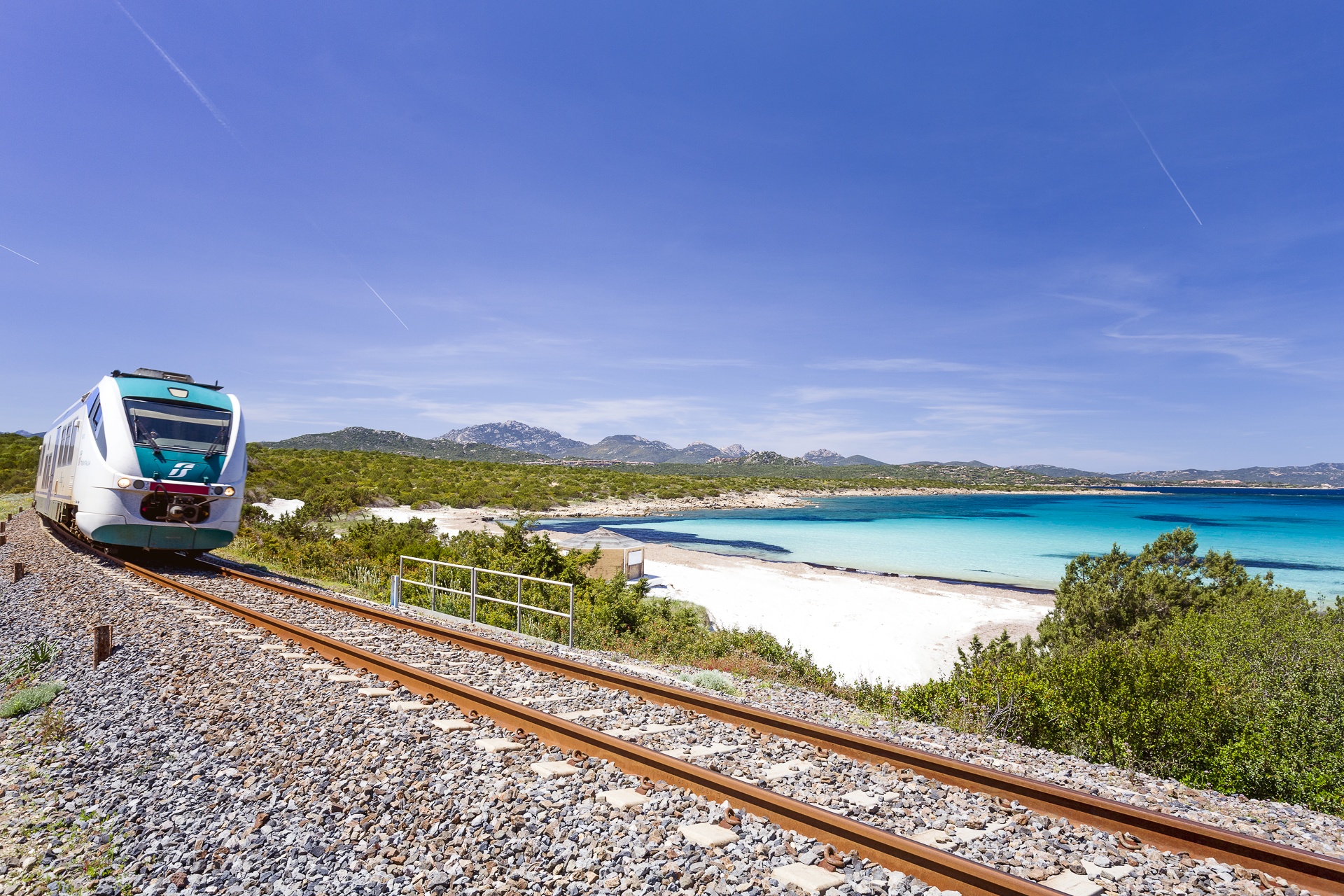
Aboard a train, on a small railway line that runs from Golfo Aranci along the northern coast of the promontory of Capo Figari, you will get to one of the most beautiful and distinctive beaches of the Gallura coast. A large beach with about 300 metres of fine white sand, surrounded by junipers and Mediterranean scrub: this is Cala Sabina, a few kilometres from the residential area of Golfo Aranci, the territory it falls within, and about twenty kilometres from Olbia. Its name has an unusual story and is the result of botanical confusion: the Phoenician juniper, which thrives around here, was mistaken for the Savin type. Another characterising element is the railway line, which was built in the 1960s, specifically to connect the residential area with the seaside resort that, until that moment, could only be reached by sea.
Protected by two small promontories overlooking the sea, the bay is well-sheltered and has shallow, emerald green waters, suitable for families, alternating with stones and rocks. The beach has a free part and a partially-equipped part with bathing and food services, thanks to bars, restaurants and tourist services for excursions. You can set off to explore the marine protected area of Tavolara – Capo Coda Cavallo.
In the reefs on the sides of the beach, you can enjoy underwater ‘explorations’, while there are small coves on the easternmost side, from which you can embark upon nature trails. Don’t miss the chance to visit the promontory of Capo Figari, also famous for Guglielmo Marconi’s technological experiments, and reach another pearl of Golfo Aranci, that of Cala Moresca.
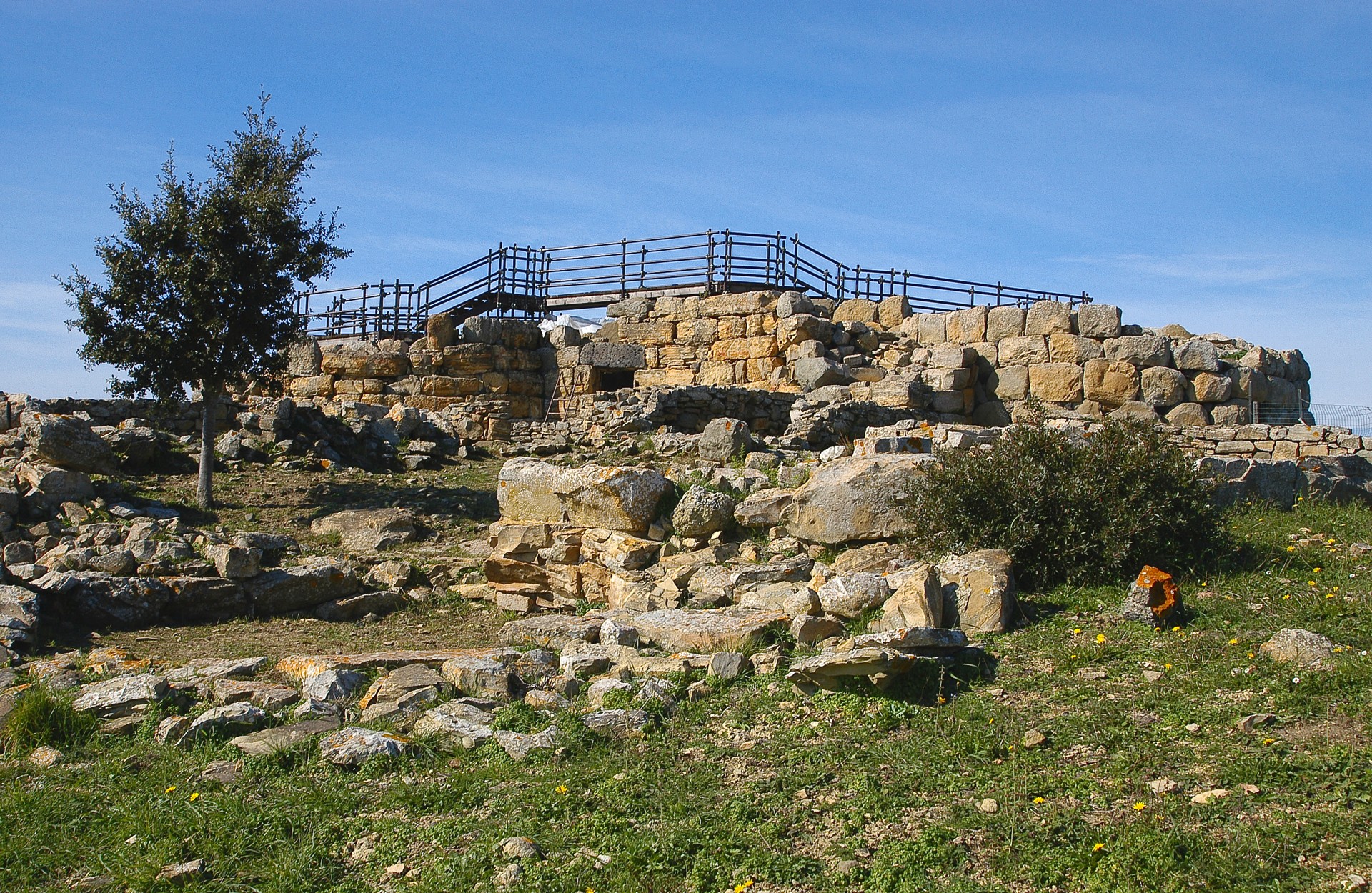
Nuraghe Genna Maria park and museum
Over 400 metres high, in the setting of a wooded park, fragrant with Mediterranean essences, it dominates the entire subregion of Marmilla: the view stretches all the way to the Gulf of Oristano to the west and to Cagliari, 50 kilometres away, to the south. The Nuragic complex of Genna Maria stands on a hill, watching over the territory, one kilometre from Villanovaforru, a village that was founded under Spanish domination and became famous after its discovery in the middle of the twentieth century. It is a Nuraghe with a complex structure: originally, in the 15th century BC, a central fortified tower (two metres tall) with an inner room, was surrounded by a bastion with three large towers joined by thick walls, which still enclose a courtyard with a well partly dug out of the rock. In a second phase, at the beginning of the Late Bronze Age (13th century BC), the tower was enclosed and partially surrounded by a bastion with four towers that had slits in them. In turn, the quadrilobed rampart, the function of which was presumably defensive, was enclosed (11th century BC) by sturdy city walls with six corner-towers. Both inside and outside of it, there is the village, which emerged around the 10th century BC and was built in several phases, as is evident in the evolution of the dwellings. The most recent huts have a complex central-plan structure, with elliptic, quadrangular and rectangular rooms that are functional and decorated with various shapes. The 'house with a central courtyard' is exceptional. It is 150 square metres in size and is divided into spaces that converge into a single courtyard.
The complex remained unpopulated for a long time during the Iron Age and then, in the Punic-Roman age (from the 4th century BC), it was used for votive purposes in honour of Demeter and Persephone: bloody sacrifices were made in the open-air courtyard, while in the centre of the room there was a sacellum used as a simulacrum and for ex voto offerings from worshippers. The precious artefacts, a good 600 oil lamps, coins, vitreous and earthenware pots, flasks, small jugs, ember-carriers, cooking bowls, millstones and animal bones, can be attributed to seven centuries of frequentation and they bear witness to the industriousness of the Nuragic and Post-Nuragic communities. Today, they are kept in an elegant nineteenth-century building in the centre of the village, once a 'Monte Granatico' (a 'grain bank'), which later became the archaeological museum of Genna Maria. Findings from the Pre-Nuragic, Nuragic, Punic and Roman periods and from Late Antiquity are also on display here and come from settlements, necropolises and monumental tombs in villages in the Marmilla area, which form the consortium of Sa Corona Arrubia. Inside, you can relive the everyday life of the Nuragic populations and the evolution of sacred rituals, until those of the Roman and Byzantine periods.
Albagiara
This small village has fewer than 300 inhabitants living at the base of the Giara di Gesturi plateau, in the upper Marmilla. Albagiara became an independent municipality in 1959, upon being detached from Usellus. As a hamlet, it was called Ollastra Usellus before taking on its current name, which poetically refers to the sunrise at the edge of the Giara. The village is divided into four neighbourhoods: San Pietro, Planu-Ibba, Pinna Fiscura and Su Forraxi, characterised by stone houses and ancient portals.
The territory of Albagiara is rich in archaeological remnants dating back to the Nuragic and Roman ages. In fact, it stands very close to the ancient city of Uselis, founded by the Romans in the late Republic era and renamed a colony in the imperial age. The geographer Ptolemy recalls it as Iulia Augusta Uselis and so it is mentioned in a bronze tablet from 158 AD, kept in the National Archaeological Museum in Cagliari. The first canonical registers in which the name of Ollastra Usellus appears date back to 1341. In the Middle Ages, the town became part of the Giudicato of Arborea.
A cultural visit to the centre of the village is not complete without a visit to the fascinating parish church of San Sebastiano, rebuilt on a structure that was probably medieval, from between the 17th and 18th centuries, as indicated by the curvilinear façade with crowning and an inflected arch and addition of the side chapels.
In the surrounding territory is the forest of su Padenti, luxuriant with holm oaks, oaks and cork oaks, offering a refreshing visit sheltered from the sun on hot summer days. From the olives comes a particularly tasty quality of oil, whilst the almonds form the basis of the traditional sweets that enliven the religious festivals (amaretti, gateau and gueffus), comprising some of the local productions par excellence from the fields of Albagiara.