
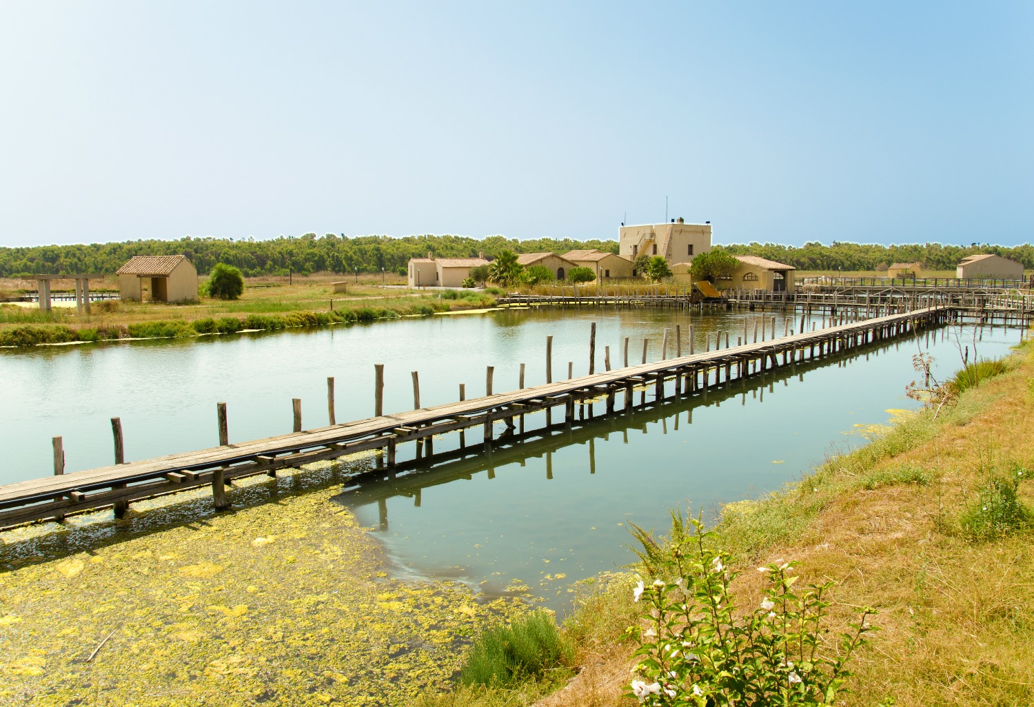
Pond of Cabras
In this exceptional swamp environment within the splendid Sinis Peninsula, you will experience the singular sensation of continuity between land and sea. The Cabras pond, one of Europe’s largest, forms, with the humid areas of Mistras, Pauli ‘e Sali and Sal’e Porcus (which is part of the territory of Putzu Idu), a site of international interest, according to the Ramsar convention. Subdivided in two basins, for a total of 2,200 hectares, the pond touches Cabras and occupies a fifth of its territory, with a particular duck shape when seen from above. The lagoons are the dominant features, identifying this part of the Oristano area and providing its inhabitants with life and trade. This heritage is accurately protected: the 40 kilometres of coast that Cabras overlooks are part of the Sinis Protected Marine Area, where splendid quartz beaches alternate with tall cliffs.
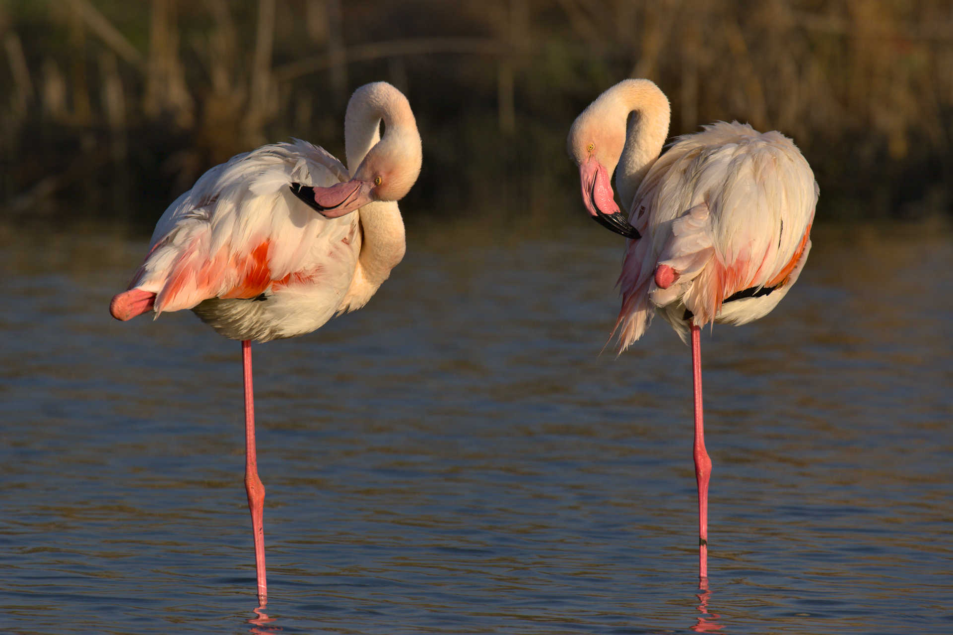
Traditional fishing is a local source of income and part of tradition. Fishing is done on is fassonis, boats made of twined swamp grass, also used for artisan baskets – evidence of a centuries-old activity in waters rich with eels, mullets, sand steenbras, gilt-head breams and European seabass. The historical Mar’e Pontis fishing grounds, with its fishing tourism, is the symbol of an area that is perfect or fishing tourism and sailing excursions, surrounded as it is by fields and hills perfect for mountain biking. It is also the perfect place for bird watchers: these are nesting grounds for mallard ducks, red-crested pochards and pink flamingos. Among its reeds you can see black-winged stilts, western marsh harriers, common moorhens and western swamphens. Peregrine falcons, yellow-legged gulls and Audouin’s gulls fly around the rocks on the shore.
This rich land has always been inhabited by humans. Do not miss the Tharros site and, at the Cabras Civic Museum, the Giganti di Mont’e Prama, enormous stone statues dated back to the 8th century BC, the most extraordinary archaeological discovery of the 20th century in the Mediterranean. A delicious local tradition is the Ipogeo di San Salvatore, a destination of the Corsa degli Scalzi that is five centuries old. The Corsa is one of Sardinia’s most interesting festivities. Local cuisine is very traditional: from mullet eggs, locals obtain bottarga, Cabras’s gold. Wine production is as old as the Nuragic age; the top local product is vernaccia.

Omodeo
In the past, the most important basin on the Island was, for a long time, the largest in Europe and is currently a tourist attraction rich in history and charm. The Omodeo lake stretches for almost 30 square kilometres, belonging to eleven Municipalities in the province of Oristano, in the historical territory of the Barigadu. It is formed by the barrage on the Tirso river: from 1924 until the end of the 20th century the river was closed by the 'historic' dam of Santa Chiara. The barrage designed by Angelo Omodeo for regulating the course of the river, for producing energy and for irrigation, was built in five years by 16 thousand workmen and was inaugurated by Victor Emmanuel III. In 1941, while the Second World War was underway, the dam was attacked by torpedoes from British aircraft. It was replaced by a new one, which was a hundred metres high and 582 metres long, named after Eleonora d'Arborea, built in 15 years and inaugurated in 1997. The previous barrage was partly submerged by the new construction.
The valley covered with water contains an archaeological treasure: Nuragic settlements and the pre-Nuragic one of Serra Linta are under the water together with an ancient fossilized tropical forest, dating back approximately 20 million years, and the evocative little village of Zuri. The village, which was sacrificed when the dam was constructed, was rebuilt upstream, together with the Romanesque church dedicated to San Pietro Apostolo (dated 1291), taken apart and rebuilt ashlar by ashlar (1923). Before the new dam was built, in periods of drought, evidence of the populations that inhabited the Medio Tirso area reappeared. This still happens today: the villa of the station manager recently re-emerged completely and has become a tourist destination. The house and nuraghi emerge with a colour that matches the land because of the silt deposited on it, giving the sensation of a crystallized and enchanted world.
The Omodeo is part of community sites of scenic and environmental interest. In fact, the history of this magical place is accompanied by natural beauty. The lake is surrounded by basalt plateaus, rugged mountains and captivating vegetation: holm oaks and Mediterranean scrub, as well as downy oaks, willows, poplars and elms. When exploring the waters in a canoe or kayak and the banks while trekking or taking relaxing walks, you will observe the flight of peregrine falcon and the jay, various species of ducks and herons, turtles and tortoises.
S'Ena Arrubia
It is a portion of the enormous swampy territory to the south of Oristano, reclaimed between 1934 and 1937. S’Ena Arrubia, nestled between the coastal pine forest and the very long and sandy beach of Marina di Arborea, is the “wreckage” of the great Sassu salty pond, originally subdivided in 200 small all big swamp areas and covering more than thirty thousand hectares. Today, the pond includes one tenth of that huge land, and has become an independent basin, saved from draining and fed by artificial sweet water canals. It flows into the sea by means of portcullises located near the fishing village called Marceddì, looked over by 16th-century Torrevecchia tower. Here, a cooperative regulates the activities in the waters of the pond, and every year it captures tonnes of eels, carps, mullets and sea bass, delivered to the tables of restaurants of the area and of Sardinia as a whole.
This abundance of fish, together with the low depth of the pond (from half a metre to one and a half metre), is a fabulous attraction to countless species of water birds. Some very rare species nest on their edges: red herons, red-crested pochards and common kingfishers. Coots, gulls and western swamphens also find their ideal habitat among the swamp flora (cordgrass, reeds and glasswort) and the azure water of the pond. In this bird watchers’ paradise, there are plenty of fascinating colours and the elegant movements of pink flamingos, who stop here in their migration routes between Africa and Europe. This high bird population have turned s’Ena Arrubia into oasis of animal protection acknowledged by the Ramsar Convention (1977), and a site of interest for the community. Near the swampy area, between pine groves and beach, it is possible to camp in contact with nature.
The centre of Arborea is six kilometres away from the lagoon. Founded in the 1930’s following the reclaiming of the Sassu, it has a typical regular structure: straight, parallel tree-lined streets and two-story houses in Liberty and neo-gothic style, surrounded by green. It is one of Sardinia’s largest centres for agricultural and livestock production.

Gonnosfanadiga
It is located at the foot of the granitic Mount Linas, in a natural unspoilt park with varied nature, which also includes the limestone massif of Marganai, the plateau of Oridda and the lush forest of Montimannu. Gonnosfanadiga, a village with almost seven thousand inhabitants, is located in one of the most ancient areas of land in Europe (it emerged 300 million years ago): wild peaks, deep gorges and steep rock faces. In between the pink and grey peaks of the Linas massif, streaked by torrents and waterfalls, there are green holm oak forests, cork oak and yew forests and Mediterranean scrub, the habitat of rare species like the Sardinian deer and the golden eagle. A network of paths leads into the woods: you can enjoy trips on foot, by mountain bike and on horseback. Along with the mountainous landscape, there are rich mineral deposits, used since Antiquity, until the 1960s. The industrial architecture is still fascinating, including various abandoned mines, among which that of molybdenite in particular, situated in Perd'e Pibera, now a beautiful park.
Gonnosfanadiga is the city of olive oil. The other excellent products are table olives and typical local bread, meats and cured meats, honey and pastries, vegetables and fruit. You can enjoy typical Campidano dishes during the bread festival in October and the olive festival in November. Wooden, cork, ceramic objects and fabrics are also famous here, but the area is especially known for the master knife-makers of Gonnos. Among the religious buildings, one that stands out is the parish church of Santa Barbara, built in the Giudicati period in place of the more ancient church of Sant'Antonio Abate, of which the bell tower (1388) and a lateral chapel with a cross vault still remains. Of great historical importance is the church of Santa Severa, the founding of which corresponds to the arrival of the Greek evangelizers on the Island (6th century) or maybe even to the Early Christian period (4th-5th century). It stands on a hill a few hundred metres from the residential zone, in the area of a Roman necropolis. It has a Latin cross plan with barrel vaulted spaces. Earlier than the evidence of a Byzantine presence here, are numerous Roman relics: coins, weapons, the remains of fortifications and encampments, tombs and four cemeteries. The first traces human presence in the territory go back approximately 7000 years: about ten settlements from the ancient Neolithic period. In the locality of Pal'e Pardu, there are the remains of a Protonuraghe. The most important Nuragic evidence is the Tomb of Giants of San Cosimo, one of the main megalithic buildings in Sardinia, with a semi-circular exedra of 26 metres, in which there is the entrance to the tomb chambers, twenty metres long.
Asuni
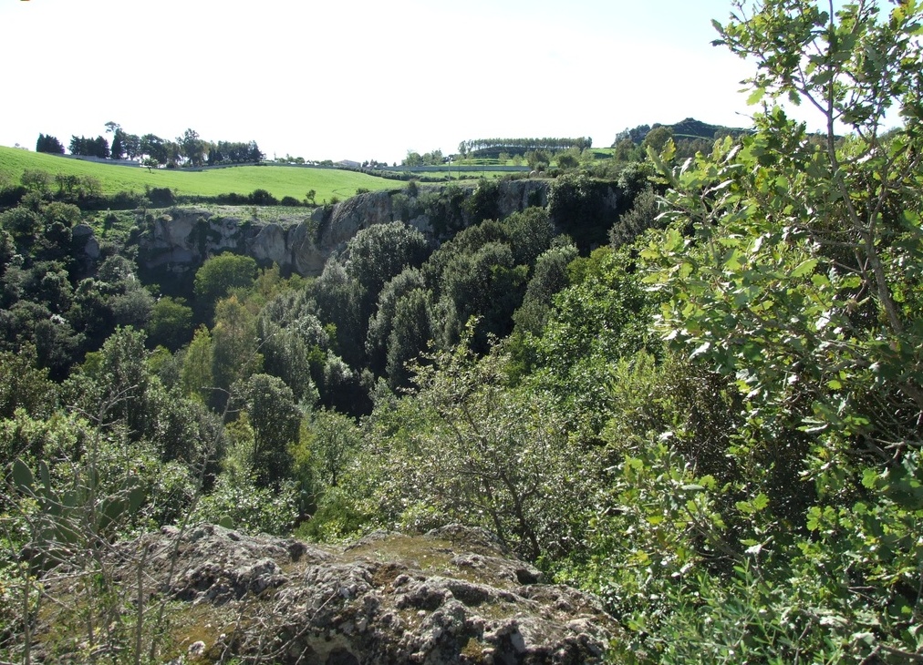
It is situated on the slopes of the hill of San Giovanni, between the gorges of the Imbessu river and the Riu Maiori, between upper Marmilla and Sarcidano. The territory of Asuni, a small village with less than 400 inhabitants in the Brabaxanna (`door of the Barbagia') area, is characterized by the charming places in the valley of Misturadroxiu-Maiori, dating back to the Paleozoic era. They look like paintings: you can observe lush cork oak and holm oak woods, sheer rock faces, shady valleys running alongside the watercourses and caves dotted everywhere, particularly Su Stampu de Muscione Mannu, in the locality of Costa Ualla. Quarries and mines also appear (Piscina Porcus and Molinu de Jossu) from which a famous type of marble was once extracted.
The name of the village may come from the Latin word agaso, meaning 'stable boy', or from the Logudoro word asone (asuni in Campidano dialect), meaning guardian of the pack, confirming its agricultural and pastoral origin. The historical centre of the village features narrow streets, where the typical lollas (courtyards) open up and can be accessed through ancient arched gates. Although it is part of the Municipality of Samugheo, the ruins of the Castle of Medusa are closely linked to Asuni. According to legend, the ghost of the queen of the same name roams around inside the castle. The fortress, the first evidence of which dates back to 1189, stands overlooking the gorge formed by the Riu Aratisi, entirely carved out of the marble. It was built in the Byzantine period and its function was to control and protect against the Barbagians, who entered Marmilla to plunder. Today it is completely immersed in the dense vegetation.
The first evidence of humans in the fields of Asuni date back to the Neolithic era: you will find menhirs and Domus de Janas in Carupixidu, Sa Rutta, Ebras Noas, S'Utture is Xorrus and above all, in the outskirts of the village, there is the necropolis of Budragas. Three nuraghi date back to the Bronze Age: Casteddu, Oru and San Giovanni.

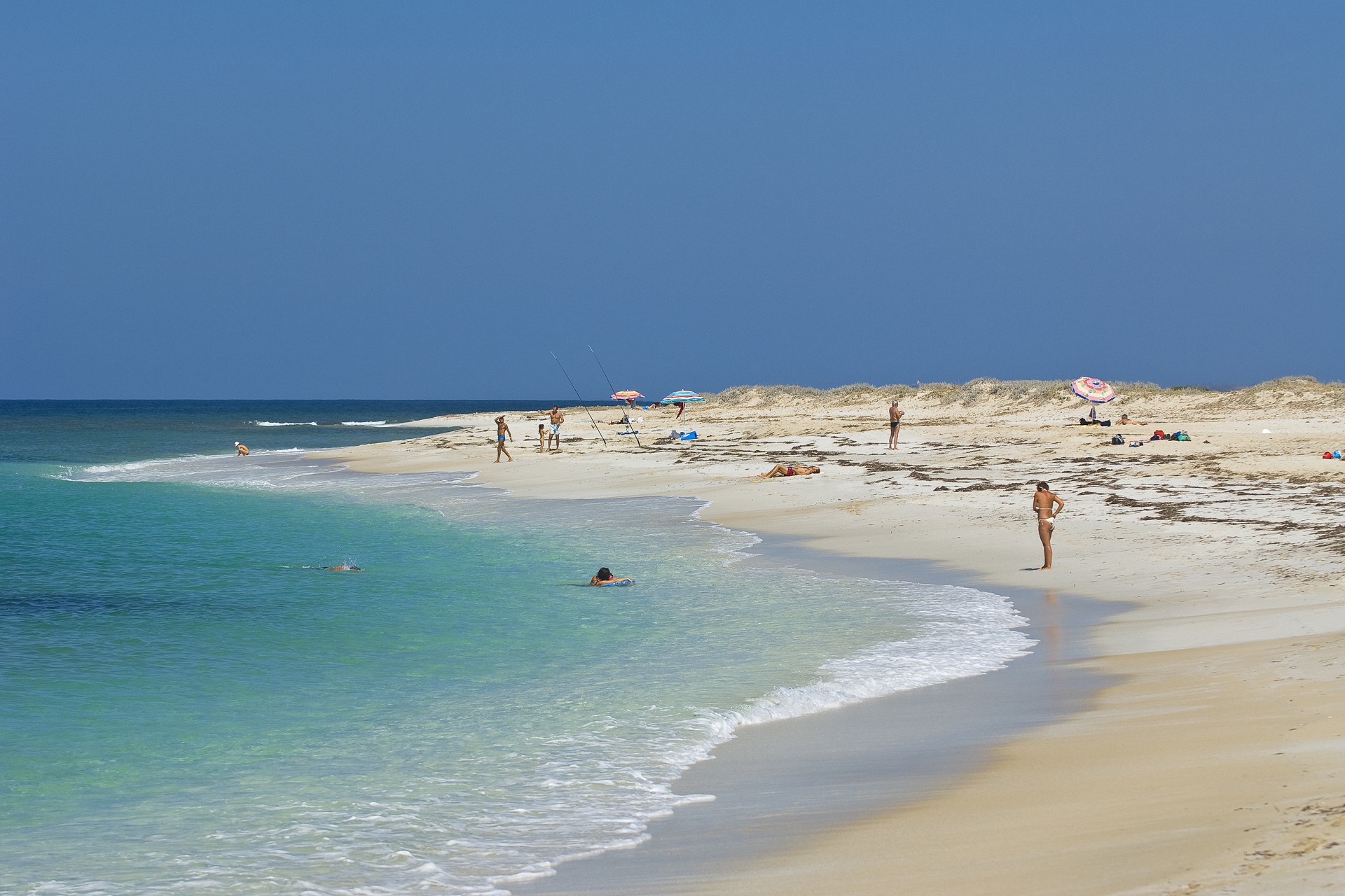
Mal di Ventre
Originally it was named MaluEntu, now known as Mal di Ventre. Perhaps it was a mistranslation. Named for its persistent winds, especially north wind, that often make for dangerous sailing around it. However, the remains of a nuraghe, other ruins and wells for collecting water show that the island was once inhabited. Reached from the ports in the Oristano gulf, it is five miles from Capo Mannu and is part of the Sinis peninsula marine area, in the territory of Cabras, which also includes the nearby Catalano rock.
Mal di Ventre is a flat expanse of granite, two and a half kilometres long and one kilometre at its widest. The lighthouse that dominates the island is placed at its highest point, just 20 metres above sea level.The "table" of 85 hectares, covered by arid steppe dotted with Mediterranean brush, is populated by rabbits and turtles. Monk seals are rumoured to have been seen. The island is a strategic stop-over for various nesting birds: Eleonora's falcon, shags, Mediterranean shags, short-tailed shearwaters and gulls.
The western coastline is rocky, featuring CalaMaestra and CalaPonente. The eastern shore offers enchanting coves with small, sandy or quartz beaches such as CalaValdaro, very similar to Mari Ermi opposite, one of the three "pearls" of Sinis, together with Is Arutas and Maimoni. On the island, don't miss Punta Libeccio and Caladei Pastori. The seabed is ideal for diving, inhabited by crustaceans (lobsters and langoustines), molluscs and infinite species of fish, including barracudas, grouper fish, croakers, sea bass and breams. Dolphins can often be spotted. It is not by chance that the site is of community interest and under special protection.
The unpredictability of the sea has created a ship graveyard in the vicinity for Roman, Spanish, 20th century and other ships. In the Denti di Libeccio, to the west, at a depth of 27 metres, lies an incredible discovery: a 36 metre Roman shipwreck that sank between 80 and 50 BC, carrying 2000 lead ingots. At Caladei Pastori lies the wreck of a steamboat, while to the north, at Formiche di Maestrale, lies the Joyce, a merchant ship from Cagliari that sank in 1973.
Riola Sardo
The village is located a few kilometres from the spectacular cliffs and splendid beaches of the Sinis peninsula, on the banks of the Foghe rivulet, on a fertile plain surrounded by lagoons and inhabited since prehistoric times, as shown by the presence of about ten nuraghi (some frequented in the Punic period). Riola Sardo is an agricultural village with just over two thousand inhabitants in the Campidano part of Oristano, once famous for its cereal crops and nowadays for producing fruit, vegetables and wine, especially Vernaccia. The sea, the river and the ponds of is Benas, Sale Porcus and Cabras have always been traditional fishing areas. Campidano ‘courtyard’ houses made of mud bricks (ladiri), with stone gateways and wooden architraves characterise the old village centre: the seventeenth-century Casa Carta, a charming aristocratic dwelling. Behind it, stands the parish church of San Martino, rebuilt in the 16th century over a previous Romanesque building. You will see its Baroque façade at the top of a flight of steps and, alongside it, an octagonal bell tower, crowned by a dome covered with multi-coloured tiles. Inside, you can admire a sixteenth-century crucifix, two 17th-century holy water fonts and a decorated wooden choir. The religious and civil celebrations of the patron saint of the village take place on 11 November: during the day you can taste the new wines in the wineries. The most heartfelt celebrations take place at the end of July in honour of St Anne and St Joachim: the procession is accompanied by a parade in traditional dress and the sound of the launeddas. On the outskirts, you will see the ruins – the foundations and one wall with two recesses – of the church of Santa Corona, possibly dating back to the 12th century. An analysis of medieval texts it appears that it was built by and belonged to the Templars. This is confirmed by numerous decorative symbols linked to them, once furnishings in the church and later re-used to decorate the façades of the houses. The building was renovated in the 17th century and mysteriously abandoned in the 1930s.
In the disused sandstone quarries of su Cuccuru Mannu, near the village, the evocative Parco dei Suoni (Park of Sounds), emerged and, in July and August, jazz, pop and rock concerts are held here, as part of the Grandi Eventi network. It consists of a series of paths with sound effects, almost all in the open air, between quarries adjoining areas, trails and environments that seem like 'sculptures of sound’, each linked to a field of music. Other events not to be missed include the motoraduno internazionale della Vernaccia (international motorbike gathering of Vernaccia) in mid-September, with wine tastings and, on the subject of wine tasting, in November, there is Sapori Antichi (Ancient Flavours), with tastings of traditional cuisine, while in February, on the theme of motors, the International Motocross Championships take place.
Maimoni
An expanse of two kilometres of light sand, enhanced by grains of quartz with various tinges of white and pink, typical of the Cabras shoreline, which is 13 kilometres away. The amazing and precious beach of Maimoni, with characteristics very similar to the nearby and equally beautiful Is Arutas and Mari Ermi, is located in the marine area of the Sinis peninsula and its name comes from the Sardinian and Phoenician god of water and of the rain. Also linked to the divinity, in a sort of religious continuity, is the church of San Salvatore, built in the 17th century on the ruins of an early Christian hypogeum, a few steps from the beach.
The coastline is wide and long, with some stretches that have rocks on the shore. The water is crystal clear and transparent, the blue and turquoise colours of the sea, the sandy, gently sloping seabed, ideal for children to swim in, although with caution as the northwesterly mistral wind often creates high waves. Not surprisingly, Maimoni is a great attraction for kitesurfing, windsurfing and surfing enthusiasts.
The beach, which has ample parking, a bar and restaurants, is bordered by dunes covered with Mediterranean scrub and ponds that are part of the protected area. Along the road to the beach, the charming village of San Salvatore is located six kilometres away: at the beginning of September, worshippers from Cabras come here for the Corsa degli Scalzi, a heart-felt procession, as well as one of the most evocative events linked to the identity of Sardinia. The village is known as a film location for the Cinecittà Italian film studio: between the 1960s and 1970s it was the setting for famous 'spaghetti western' films. As well as the three quartz beaches (Is Arutas, Maimoni and Mari Ermi) along the Cabras shoreline, a visit to the fine sand of San Giovanni di Sinis is also a must.
Norbello
Lying on the Abbasanta plateau, it offers a panoramic view of Lago Omodeo and the Chenale valley, coloured by woods of oak and sessile oak, Mediterranean scrub and orchids, interlaced with paths and interspersed with ‘healing’ springs. Norbello is a town with 1,200 inhabitants in Guilcer, on the border between the provinces of Oristano and Nuoro, having seen continuous expansion and a strong agricultural-pastoral marking, including with the breeding of Sardinian Anglo-Arab horses. Nature, cultural vivaciousness, a textile tradition and oenogastronomy have earned its inclusion amongst the most authentic villages of Italy. The urban architecture is quite evocative, with the streets and squares being enriched by monuments and paved with basalt. Even the façades of the houses and shops are in dark stone, the balconies decorated with geraniums.
In the middle of the village stands the Church of Santa Maria della Mercede, built in Romanesque style (12th-13th century) on the site of a prior medieval necropolis (6th-7th century). Within are ten Templar crosses with graffiti on the plaster and red painted images. At the end of the 12th century, two knights of the order of Jerusalem consecrated the church with the typical Templar symbolism. Perhaps contemporaneous with the ‘Mercede’, celebrated at the end of September, is the Romanesque structure of the parish church of the Saints Cyricus and Julitta. The festival of the two patrons is held in mid-July. The church of San Giovanni Battista is also quite interesting, with a parchment certifying its existence as early as 1265.
The village, initially called Norgillo and then Nurghillu, before finally taking the name Norghiddo (from which derives the Italian Norbello) has always been linked to the fraction of Domusnovas Canales, which is built around the Chiesa di San Giorgio. The village of Sella once formed part of the territory, being of great importance in the area of the Giudicato d’Arborea, with there being the remains of a 10th-century castle. In the nearby sanctuary of San Giuliano, there is an ancient well linked to the ‘miracles’ of the saint. Eight kilometres from the village is the Church of Sant’Ignazio from Laconi, first consecrated by the Capuchin friar (1951). In the surrounds is a village of muristenes, being pilgrims’ lodgings for the mid-September festival. The calendar of events offering tastings of delicious cheeses, cured meats and desserts, commences in January with the Fuochi di Sant’Antonio Abate with its large bonfire, and ends in September with the Sagra della Vendemmia Antica (ancient harvest festival).
The rich archaeological heritage is conserved in part within the village’s antiquarium. Dating back to the Neolithic period are a dolmen, two villages and four Domus de Janas necropolis, including Sunu Marras, thirty Nuraghe structures from the Bronze Age. The Sirboniga and Suei complexes and monotower of Ruiu and Perdu Cossu are other well-conserved monuments. Quite unique is Sa Codina ’e s’Ispreddosu, a Nuraghe structure that was never finished, being a place of worship in the Iron Age. Together with the Nuraghe structures, are eleven Tombs of Giants and six sacred fountains, including the Ampridorzos. The 17 sites in which Punic-Roman cinerary urns have been discovered are also a rarity. Also worth a visit is the MIDI museum, which displays two thousand cartoons.
Simala
Set in the gentle landscape of northern Campidano plain, it is the town of gates: dozens of various architectural value can be seen in the town centre. Simala a small town with 350 inhabitants in Upper Marmilla. Founded in a fertile valley crossed by Rio Mannu and cultivated for cereals, legumes, fruit, grapes and olives. The river, once called the ‘sacred river’, flows through cane thickets and groves of poplars and willows in a sacred pre-Nuragic area with a menhir related to the water cult in its centre. It is the most important Neolithic site in an area at the foot of Monte Arci Park and its deposits of obsidian, the Prehistoric ‘black gold’ of the Mediterranean. Numerous Bronze Age sites are in the area: the Giant’s Tomb of Piscina Craba and about a dozen nuraghes. Following Roman conquest, the area was densely populated and mined for lead and silver. Evidence of many settlements and traces of a road connecting Neapolis to Uselis are still visible. The most important Roman site is the Rustic Villa of Gemussi, equipped with thermal baths embellished with mosaics and other decorations. The Paleo-Christian Cemetery of Santu Sadurru is also of note.
The town’s name is said to derive from the Semilitenses, who lived here before the arrival of the Romans, or from the Greek thymalla, euphorbia, which is abundant in the area. The original town is Early Medieval in age. The first mention of the town dates to the end of the 11th century, during the rule of the Giudicato of Arborea, when the Church of Santa Caterina d’Alessandria was given to Vittorini monks. The church is one of the Byzantine holy houses that have been destroyed, just as the villages of Pardu and Gemussi, but whose names are still in use. The current town is arranged into two axes at the intersection of which stands the Parish of San Nicola, a unique example of 18th century sacred architecture characterised by an extremely original dome. It houses prized marble and wood altars of the Piedmont and Liguria schools and decor including silver items (15-19th centuries), 18th century vestments and hand-made carpets. During the patron saint’s feast in early December, chestnuts and novello wine are offered around a bonfire. In early October, Saint Vitalia is celebrated at the country church dedicated to her with a procession in traditional dress. The town centre also contains a grain bank and noble residences of Neoclassical inspiration: the oldest is the residence of the Monserrat Deana family (1554). The winding side roads are lined with “rural” courtyard houses, with porticoes surrounding cobbled courtyards. The facades are embellished with monumental gates. Some houses have two, one to enter the house and another to enter the porticoes. In total, there are about 60, with exposed stone, arches, wood architraves, friezes and terraces. A unique characteristic with respect to other nearby towns is the presence of ‘pigeon lofts’ over or next to the doorways.