

Villagrande Strisaili
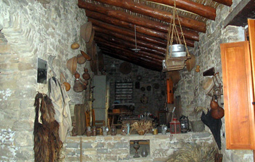
This is the village of longevity, with the world’s highest concentration, compared to births, of people over the age of 100. Since WWII, more than thirty locals have made it to ten decades of life. Villagrande Strisaili has a population of 3,200 and sits at an altitude of 750 metres on the southern slopes of the Gennargentu, in deepest heart of the Ogliastra area, yet just minutes from the eastern coast. Its western flank is protected by Mt Suana, to the north are mounts Isadalu and Orguda, while to the south is monte Idòlo. All of these mountains exceed altitudes of 1,300 metres and are interspersed with high plains and valleys. The town looks eastward over the Ogliastra plains to the Gulf of Arbatax. It’s area ranks third in size and is made up of steep rocky cliffs, covered with stands of various types of centuries-old oak trees that are the habitat of mouflons and royal eagles, crisscrossed by a network of rivers and streams from springs. The area also comprises monte Novu and the parco di santa Barbara, steeped in prehistoric remains: seven giant tombs and a megalith, 17 nuraghes and ten nuragic villages. In early July they celebrate their saint with festivities in the park. A path leads to the spectacular Sothai falls, where the Flumendosa river falls down into the Bau Vigo canyon. Seven kilometres from Villagrande, at the centre of the high plains, on the shore of Flumendosa Lake, is Villanova Strisaili, home to nature of the wildest sort: the Pirincanes gorge and the Rio ‘e Forru falls. You can reach these two marvels via a trail and admire them from a natural belvedere. The surrounding woods complete the picture with a thick layer of Mediterranean underbrush. Here lie other pre-nuragic remains: five stone domus de Janas chambers and the sa Pred’e s’Orcu menhir. The most important Nuragic site is by the lake, s’Arcu ‘e is Forros. Next to three-lobed nuraghes and huts is a megaron temple made of blocks of granite and schist. Other archaeological treasures include the Troculu complex, with two nuraghes, a village and giant tomb, as well as the archaeological area of sa Carcaredda, with four giant tombs near a rare in antis temple and village.
Tradition has remained unchanged here for centuries: they celebrate the bonfires of sant’Antonio Abate and the feat day of San Sebastiano early in the year. The patron saint San Gabriele, to whom the church is dedicated, is celebrated on the first of August. Even the cuisine has retained its traditional flavours, with prosciutto ranking as the star of local delicacies. Others include: is gathulis, fried doughnuts, is culurgiones, ravioli filled with potatoes, pecorino and basil, then roast meats and sa paniscedda, sweets made with honey, grapes and almonds.
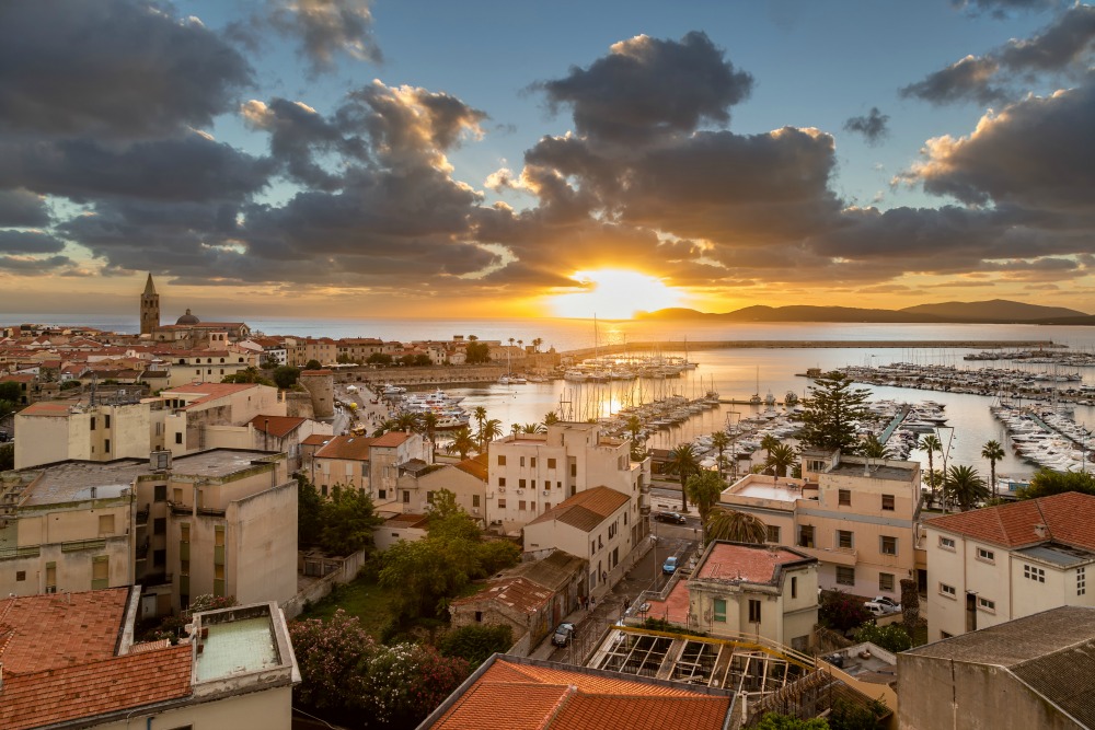
Alghero
With its 44,000 inhabitants, it is the 5th largest city of Sardinia. Alghero is the island’s main harbour town, home to Fertilia airport and one of its best-loved cities for the popular walkway along the port’s bastions, the red roofs that touch the sky and the gorgeous natural bay that flows into the emerald sea. The shoreline is some 90 km long and known as the Coral Riviera, home to a major colony of the finest coral. The most famous beach here is Le Bombarde, blessed with crystalline water and a clean sandy bottom, it is a favourite destination of families, young people and surfing enthusiasts. Just a kilometre away is Lazzaretto, ten inlets with soft sandy beaches. A bit further away in the bay of Porto Conte is the leisurely Mugoni beach, graced with golden sand and the still waters of a sea that is always calm and crystalline, a completely protected oasis. The shoreline at the city’s centre, on the other hand, is home to the splendid Lido di San Giovanni beach, while just outside of town are the Maria Pia dunes, dotted with centuries-old juniper trees. Much of the coastline is within the protected marine zone of Capo Caccia – Isola Piana, where hundreds of treasures are safeguarded, including the grotta di Nettuno, which can be reached over land via the Escala del Cabriol, and by sea with boats that depart from the harbour.
The Porto Conte park will amaze you with its expanses of Mediterranean brush, dense woods and the laguna del Calich. The domus de Janas of santu Perdu, the Anghelu Ruju necropolis and the complexes of Palmavera and sant’Imbenia bear witness to Alghero’s prehistoric origins, starting in the Neolithic era. The historical centre is the city’s most interesting area, a labyrinth of narrow streets that connect piazzas bustling with life. The yellow walls and ancient houses echo the Catalan origins of the city. As do the churches: the Cathedral of Santa Maria (XVI century), the churches of Carmelo (late XVII century) with its great gilded retablo, that of San Michele with its coloured ceramic dome, and the late Renaissance Sant’Anna (1735). If it’s culture you’re after, then visit Casa Manno, a research centre full of important paintings, furniture, books and manuscripts. Alghero is famous for its fine coral, which is used locally with gold to make every manner of adornment. Do stop in at the Museo del Corallo and learn more about the history of coral and how it is used. The big event in 2017 will be the opening race of the great multi-city Giro d’Italia cycling event. Another great time to be here is at Cap d’Any de l’Alguer, or “New Years at Alghero,” when a myriad of shows enliven the city centre. The most passionate time of year is Holy Week, with heartfelt religious rites from the Spanish tradition.

The Sea Oxen Grottoes
Here once reigned “sea oxen”, as the locals used to call monk seals due to their tapered shape and tame behaviour like that of an ox. These magnificent mammals, now (maybe) extinct, gave their name to a marvel of nature: the Sea Oxen Grottoes (Grotte del Bue marino), since the 50’s one of the main attractions of the Gulf of Orosei, in particular in Cala Gonone, in the Dorgali territory. Today they are a favourite destination among nature lovers, and the ideal union between sea and mountain: they are part of the karstic system Codula di Luna, Italy’s largest, seventy kilometres of tunnels in the bowels of Gennargentu.
Its majestic entrance, formed by two arches over the sea, is located three kilometres away from splendid Cala Luna. The marine caves are 15 kilometres long in total, and divided in two main branches. The northern branch, fossilised due to the interrupted karstic activity, is not accessible to the public. However, you can visit the southern branch thanks to illuminated causeways, for about 900 metres. Speleologists are allowed to explore an additional four kilometres (of the overall 5 of this branch). Seawater penetrates the wide hall, and countless little ponds of sweet water from subterraneous rivers abound, separated from sandy beaches filled with concrete formations. The “tourist” itinerary among stalactites and stalagmites offers an extraordinary colour spectacle, thanks to the light beams that penetrate it. You cannot help but gasp in awe at the long shadows projected on the waters of a subterranean saltwater lake, with more than one square kilometre of surface.
The cave is also famous for esoteric rock paintings, dated back to the Neolithic, illustrating a circle of people around what is supposedly a representation of the sun. The walk finishes in the seal beach – these sea mammals once came here to mate and have their cubs. The visit is led by expert guides and lasts about one hour. To reach the grottoes, use boat services leaving from Arbatax, Cala Gonone, La Caletta, Orosei and Santa Maria Navarrese. Another unique attraction of the place is the yearly celebration, inside the grottoes, of a spectacular concert as part of the Cala Gonone Jazz festival. When visiting the Gulf of Orosei, do not miss the chance to visit the magical world of Dorgali: history, archaeology, manufacturing arts and natural heritage in 225 square metres.
Grotta del Fico
At first, you will be enshrouded by the darkness, then, as you gradually move forward, you will see before your eyes a place in which time seems to have stopped 800 thousand years ago, when the first rooms of the Grotta del Fico cave were formed, one of the pearls of Ogliastra, in the territory of Baunei. Stalactites, stalagmites and columns of different sizes and colours enclose every wall of the cave, creating curious shapes. A system of tunnels and easy footbridges will allow you to walk along the fossil bed of an ancient river. The route penetrates deep into the earth, dug out by the water, within the sheer cliffs overlooking the sea of the Gulf of Orosei. Close by, there are charming little coves that can be reached by sea or via trekking trails: Cala Luna, Cala Biriola, Cala Mariolu and Cala Goloritzè.
During the first exploration (1957), the cave revealed its wild appearance and various naturalistic treasures. The writer Marcello Serra renamed it 'Cave of the Castle' due to its majestic front overlooking the sea. Open to the public since 2003 and renamed 'del Fico', it has an entrance situated at a height of seven metres up on the cliff, which you can reach from the boat by climbing up a walkway. From the entrance, you can see the nearby stretch of gulf, an amazing seascape. You will be able to visit it with expert guides who will accompany you through the main tunnel that leads to a large pool communicating with the sea. In the depths of the reservoir, the first speleologists to explore it witnessed an unforgettable sight: in that body of water, they noticed the darting bodies of the Mediterranean monk seals. Here, the first studies were conducted on the animals that perhaps left the eastern coast, but it is not uncommon to see traces of their passage. The visit to the various spaces and tunnels, embellished by limestone formations, known to date, lasts 45 minutes but for speleology experts and enthusiasts, it is also possible to visit part of the cave that is not equipped with walkways.
From the hinterland to the coast, the entire Supramonte di Baunei area conceals an underground world marked by the patient work of the water. Not far from the Grotta del Fico cave, overlooking the not-to-be-missed dreamy little cove of Cala Sisine, you will find another natural wonder, created by the dissolving limestone: it is the Grotta del Miracolo (Cave of Miracles) and you will understand the reason behind its name when you visit it.

Montresta
It is situated by Mount Navrino, in a spectacular landscape characterized by trachyte peaks and a carpet of Mediterranean shrubs and century-old cork oak woods, such as Silva Manna. Montresta is a small town of over 500 inhabitants in Planargia, on the border with Logudoro of Porto Torres. It is known for its weaving: its craftsmen produce beautiful hand-made baskets of rush and asphodel. Currently, the town is located near Bosa, 40 kilometres from Alghero and 80 from Oristano, the capital. It was founded around 1750, when the town was still called Villa San Cristoforo (even earlier, in the Medieval period, it was called Suttamonte), after the Church of San Cristoforo Martire, constructed in early 17th century. Greco-Corsican (Maniot) settlers in search of a new home were invited by king Carl Emmanuel III to populate this area and work the land.
This experiment was unsuccessful because of hostility shown by the Bosni towards the “foreigners” occupying their land. Most of the settlers left. Nevertheless, today, various elements of architecture and craftsmanship, including basket weaving, are reminiscent of Greek art. Later, the name of the village was changed to Montresta, a name that also refers to the surrounding land and may have meant “mountain of grain”. Another church worth a visit is the Church of Sacro Cuore, constructed in the 1960s on the ruins of a Medieval structure. The feast of Sacro Cuore is celebrated in mid-August in Su Casteddu, on the edge of S’Aspru Forest. The village is also known for its Mutton Festival, which should be eaten with the typical local bread called su bistoccu. In late April, on the other hand, the Feast of San Cristoforo is celebrated with a procession, tastings and folk performances.
The area has been inhabited since the Prehistoric, as seen from numerous pre-nuragic sites (Domus de Janas) and nuraghes such as Badu de Sa Rughe. The most important archaeological site in the area, a tower called Sa Turre (or Nuraghe Turre), is the only evidence of Punic settlements in Planargia. It represents the remains of a Carthaginian quadrangular fortress with evidence of brickwork once part of the defensive structure still visible at its base.

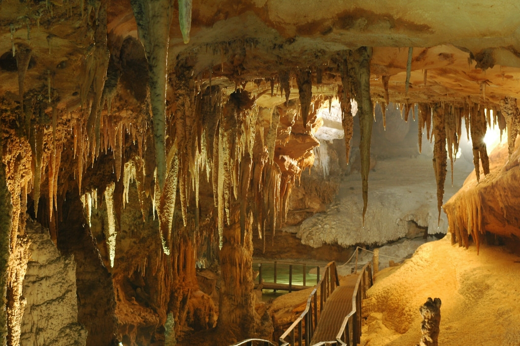
Neptune's grotto (Grotta di Nettuno)
This is a place you should visit at least once in your life: the only way to truly admire the beauty of this place and perceive its charm is in person. Neptune’s grotto is one of the largest marine caves in Italy and one of the most captivating gems of nature in the Mediterranean. The grotto was formed about two million years ago: inside, you will see rooms with astounding karst formations, a white sandy beach and a huge underground lake. The Coves de Neptú (in Catalan language) was discovered by a fisherman in the 18th century and soon became a tourist attraction. It extends horizontally for about four kilometres on the same level as the surface of the sea. Neptune’s grotto is located 24 km from Alghero and is the pride and joy of the marine protected area of Capo Caccia-Isola Piana, inside the Porto Conte Park.
You will reach the entrance by going down the Escala del cabirol, ‘Roe deer’s steps’ (in Catalan language): 654 steps clinging onto the western ridge of the promontory of Capo Caccia as far as the mouth. Otherwise, you can get there in greater comfort by sea, on the boats that depart daily from the tourist port of the Catalan town or from the pier of Cala Dragunara in Porto Conte, allowing you to enjoy the spectacular sight of the cliffs overlooking the sea. Along the way, you will be thrilled by the countless wonderful views of the Riviera del Corallo.
The tourist route through the caves extends for about one kilometre. The entrance is a passage covered by concretions of vegetation and dense with stalactites and stalagmites. A line of columns nine metres high will take you to the crystal clear salty waters of Lake La Marmora, one hundred metres long at the maximum point and nine metres deep. From here, you will begin to see a lovely sandy beach, once completely covered in pebbles. Standing in the centre, there is a holy water font, a monumental stalagmite on top of which there are little basins that act as a source of drinking water for birds nesting nearby. On the bottom of the lake, a distinctive stalagmite formation called the ‘Christmas tree’ stands out between large flowstones and calcitic festoons. A short, slightly downhill path takes you to the Room of the ruins and then to the majestic Palace room, revealing the most evocative scenario: an 18-metre tall column rises up to the vault and forms two spectacular arches, which look like they’re holding up the ceiling. Next, there is the Smith room (or the Organ room), dedicated to an English captain, who was one of its earliest explorers (19th century). In the centre of the room, you will see the great organ, the largest column in the entire grotto with rockflows resembling organ pipes. Following on is the Lace room, adorned with small columns. The tour ends with a visit to the Music stand, a balcony overlooking the ‘palace’, the lake and the beach.
In addition to welcoming an average of 150,000 visitors each year, the caves are visited by numerous speleologists, the only ones able to enter the deepest and most secret ravines reserved to expert speleologists, namely the Lake of mushrooms and, through the underground tunnel, to the huge room hosting the Crescent lake, which is 70 metres long and 50 metres deep. The caves were used as a film set: in 1978, ‘Island of the Fishmen’ was filmed there, with scenes that remind you of stories by Jules Verne.
On the cliffs of Capo Caccia, a popular destination for climbing and diving enthusiasts, other fascinating caves open up. Nearby you will find the Cave of lace and embroidery, while the most famous is the gigantic Green Cave, also called ‘Cave of the altar’. Only expert ‘cave divers’ can visit its rocky walls. A little lake on the bottom provides a greenish light. Its rooms, which were once dry, were a place of worship and a burial site from the 6th millennium BC to the Middle Ages. In the vast underwater karst system, Nereo’s cave stands out. It is the largest underwater cave in Europe and a place for unforgettable diving. In front of Capo Caccia there is the island of Foradada (meaning ‘pierced), which gets its name from a tunnel that ‘pierces’ it as it crosses it from end to end, with the Cave of Pidgeons.
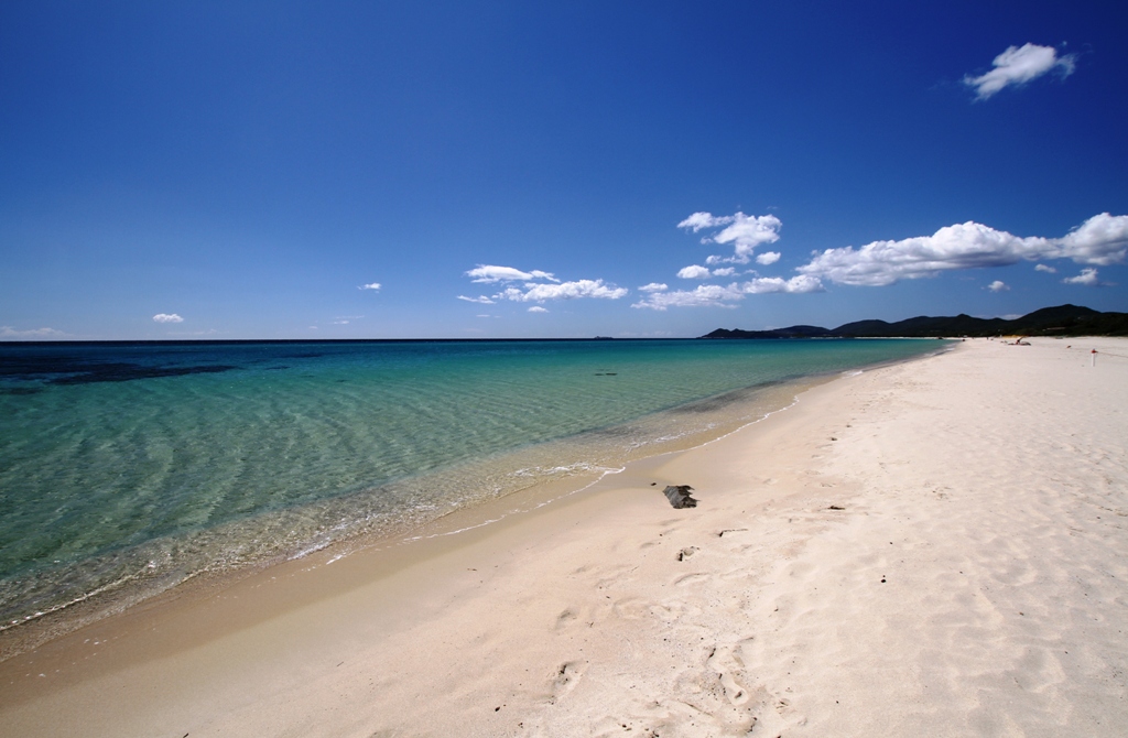
Piscina Rei
This is one of the large beaches that make up the splendid Costa Rei coastline, defined by the prestigious Lonely Planet guide as one of the top ten beaches in the world. You can reach Piscina Rei, in the territory of Muravera, from one of several access points, along a coastline bordered by junipers, Mediterranean bushes and bright white sea daffodils. The brightness and softness of the sand, the crystal clear, shallow water, together with a few smooth rocks make you feel like you are bathing in a natural swimming pool.
This is the ideal beach for families with children, the middle aged or elderly looking for relaxation, couples and singles, and is popular with underwater fishing, diving and snorkelling enthusiasts. Bars and beach equipment rental points are available. The nearby tourist town of Costa Rei offers every service and convenience.
Piscina Rei is part of the coast to the south of Muravera that extends for dozens of kilometres. From the beach of San Giovanni with its quartz sand to Torre Salinas and Colostrai, an oasis with dunes covered in sea daffodils, to Feraxi with over two kilometres of fine bronze-coloured sand. Then come the more protected coves of Portu de s’Illixi, CalasaFigu and the Baia delle Anfore (named for the Roman shipwreck), before the granite rock of Capo Ferrato with its lighthouse, and Monti Ferru, a suggestive panoramic viewpoint that can be reached on foot or by mountain bike. The 'pure white' beach of Iba de ziuFranciscu leads to Costa Rei, the longest low and sandy stretch of coastline along the eastern coast: nearly eight kilometres that stretch as far as the Scoglio di Peppino and another two in the territory of Castiadas.
Not just beaches: in the surroundings, don't miss the flamingos in the Muraveralagunas and archaeological sites: in Piscina Rei, you'll find the Cuili Piras megalithic complex, near the Nuraghe Scalas standing stones, arranged in lines according to the stars and the heavens, and the Punic Fortezza di Baccu in the overlooking locality of Nai.
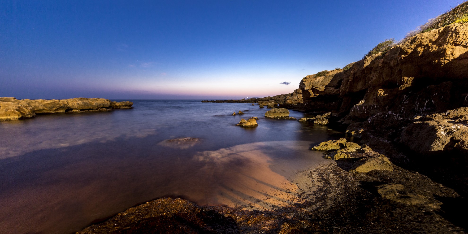
Cala Bona
A series of tiny coves and inlets, now sandy but once pebbly, enclosed and hidden by cliffs and flat, pink rocks, on which you can sit and sunbathe comfortably. Cala Bona gets its name from the fortunate ‘protected’ position in which it is located, which has always been a calm and safe haven for small boats. It is one of the coastal gems of Alghero, less than a kilometre south of the old town centre, along the provincial scenic road leading to Bosa, close to one of the most panoramic parts of the coastline, the hill of Balaguer.
The little coves have dark, large-grained sand mixed with pebbles and the sea is transparent and sparkling with green and sky blue, thanks to the reflections of the sun on the deep, rocky seabed. This locality is highly frequented by recreational fishing enthusiasts, both for fishing with rods and underwater fishing. In recent times, it was used as a sandstone quarry. On the right of the beach, there is a cave called Grotta di Costa, with a small secluded beach. In the immediate vicinity, there are various hotels and dining and refreshments areas.
Along the Riviera del Corallo, you can visit and enjoy numerous other gems: also on the road to Bosa, you will encounter Cala Burantin and the beach of Speranza. In the town, you can relax at the Lido, a city beach and Alghero's most extensive one, and at the nearby dunes of white sand of Maria Pia, where there are centuries-old junipers. Continuing on towards and beyond the small village of Fertilia, there is the delightful little inlet of Punta Negra. Then, further north, you will find the two gems of Alghero, Bombarde and Lazzaretto. In the bay of Porto Conte you will see the splendid, peaceful and large beach of Mugoni, as well as the delightful Cala Dragunara and Porticciolo.
Municipal Art Gallery and Archaeological Museum
Sinnai's museum comprises an archaeological section and the Municipal art gallery.
The archaeological exhibition includes the finds of digs and surface searches carried out from 1994 to the present. It charts human presence in the area from the Late Neolithic to the Middle Ages. The finds are almost all from the town's countryside and are placed in context by an engaging exhibition design, which includes information panels with texts and images on the sites, which accompany the whole visit.
One especially fascinating section is that on the excavations at the Santa Itroxia Nuraghe and the Proto-historic sites of Bruncu Mogumu, which have yielded a jug and a bowl from the Orientalising period, and of Papalinu. Another fascinating artefact is a terracotta statuette of Bes, a Punic-period deity worshipped as a protector of the household and good health.
A fragment of an Early Medieval epigraph mentioning Saint Saturninus, bears witness to the cult of Catholic saints in the village of Solanas (in the municipality of Sinnai) before the landing of the Victorine monks in Southern Sardinia.
The Municipal Art Gallery has works by painters from the South-eastern Campidano region from the 16th century to the present time.
The visit to the museum's collections offers an overview of the history of human presence in a large swathe of the South-eastern Campidano of Cagliari.
Address: Centro Socio-culturale "Monsignor C. Perra", via Colletta, 20 - 09048 Sinnai Phone +39 070 780516 Managing Agency: Municipality of Sinnai
Pau
It sits at an elevation of 300 meters on the western slope of Monte Arci. The largest Sardinian obsidian deposit, it frames the town it with its woods and interrupts a landscape of rolling hills, such as Su Vantosu. Pau is a small town, with little over 300 inhabitants, in upper Marmilla, a fertile territory rich in water bodies where cereals, legumes, fruit and grapes are cultivated. It may date back to the Roman period, as seen from findings of imbrices, vases, coins and traces of ancient construction at various sites, including Sa Telluri. The name likely derives from the Latin pagus (village). Three nuraghes in the area date to the prehistoric period: the single-towered Su Castiu or Spadua, and the two complexes at the Arruinas and Punta Su Nuraxi sites. Today, the town is composed of a network of streets lined with very old, stone houses with the Parish of San Giorgio Martire in the centre and the Church of Santa Prisca Martire, with an early September Feast Day, on the outskirts.
The mountain land surrounding Pau is part of the Monte Arci Park. The mountain is carpeted with greenery that covers its volcanic channels, which merge into three points, resembling those of a tripod. The peak contains at least three distinct obsidian flows that have produced about a dozen mining sites and hundreds of processing centres. The mineral, used to construct weapons and tools, is rare in the Mediterranean. From the 6th century BC, it became a great attraction for different peoples, who would come to this part of the island to restock their supplies. General Alberto La Marmora stated in his ‘Itinerary’ (19th century) to have never seen such quantities of the black, shiny rock. Some deposits and settlements fall within the lands surrounding Pau. Specifically, the large extraction and processing centre of the Sennixeddu channel, which has produced large quantities of obsidian and chipped products. A few hundred metres away, in Su Forru de Sinzurreddus, a Pre-Nuragic settlement may have stood.
Trails passing through forests of holly oaks, downy oaks and Mediterranean shrubs, populated by red and fallow deer (reintroduced) and flown over by rare birds of prey, will allow you to discover the Arci massif’s hidden qualities. The steep Corvino trail (black) passing by large masses of obsidian is famous. You can set off on the trails accompanied by a guide directly from the Museum of Obsidian, in the outskirts of the town. Inside a one of a kind museum, with exhibits containing reproductions of ancient tools and works by the sculptor Karmine Piras, you can learn about Prehistoric ‘black gold’s’ thousand-year history. In the town’s historical centre, you can visit workshops dedicated to the production of obsidian and precious metal jewellery, and admire modern sculptures cut from large black blocks, particularly those in Town Hall square.