

Museo della Civiltà Contadina e Pastorale
The museum is in Bitti in a house built in the ancient local style, with a portico and steps in granite and with wooden floors and ceilings, in the ancient quarter of Monte Mannu.
It takes visitors back in time, among old-time work tools, and the daily life objects of shepherds, farmers, craftsmen and housewives.
Part of the exhibition, which occupies two floors, focuses on the bread cycle, an activity that was the preserve of women: they made the crispy, wafer-thin 'carasau bread', which was one of the staple foods of farmers and shepherds. A variety of tools and implements, ploughs, scythes, and a sturdy country cart bear witness to the hard toil of the peasants and shepherds.
Other sections reconstruct the atmosphere of the shoemaker's and blacksmith's workshops, with tools now all but forgotten but which were once essential companions to these craftsmen's work.
An important section is reserved for the ultimate feminine craft: the weaving of bedspreads, here known as 'sas vrassatas': a slow patient task requiring both skill and strength in working on the horizontal loom.
Another section of this house-museum reconstructs the household's living spaces, with the period furniture and objects of past family life. Thus we find the faithful reproduction of an ancient parlour, known as 'Istanzia 'e Vonu', of the kitchen and of the bedroom.
Address: via G. Mameli - 08021 Bitti Phone +39 0784 414314 - +39 333 3211346 - +39 339 4365165 Managing Agency: Municipality of Bitti
Su Suercone
Characterized by a funnel shape, it has a diameter of 500 metres and it is 200 metres deep, with an overall surface area of 18 hectares. Everything in Su Suercone, which is also called Su Sercone or Sellone, is 'oversized': it is the largest sinkhole in Sardinia, the result of the dropping of a karst vault in the heart of the limestone plateau of the Supramonte di Orgosolo. It can be reached via different and long itineraries that require physical effort, adequate equipment and the support of expert guides. Crossing through the wild, unspoilt nature, between sheer rock faces, thalwegs, gorges and gullies, this is a true paradise for expert climbing enthusiasts.
It seems inaccessible, but this is only because the sheer rock face, which is practically vertical, might discourage you. There is, however, a passageway between the rocks: it runs alongside the wall in a southern direction and opens the door to an authentic and majestic natural wonder. There are several drinking troughs in the area, dug out of tree trunks, demonstrating the ancient pastoral activities that took place inside the sinkhole. In the northern part, a vertical 30-metre ponor is visible, probably communicating with the underlying karst system.
Lush nature grows inside it. Mainly on the rock faces: there are centuries-old trees about twenty metres tall and with diameters of up to one metre, while on the damp terraces, mosses and spectacular ferns are widespread.
Humans have been present in this part of the Supramonte area since prehistoric times, as is documented by numerous artefacts used for funerals and found in the clefts. The archaeological area of Campu Donianicoro is located at approximately 900 metres of altitude.
Teti
Teti, a delightful mountain village situated at an altitude of 700 metres on the northwestern slopes of the Gennargentu massif. It was suddenly in the news in the middle of the 19th century because of the discovery of the village-sanctuary of Abini, a 'federal' place of worship and a pilgrimage destination for the Nuragic populations, of which part of the village and the sacred well still remain. Numerous bronze votive statuettes were found and are now on display at the National Archaeological Museum of Cagliari. At the excavations of the tomb of Giants of Atzadalai, the most ancient Sardinian work of art (4000 BC), namely the 'Sleeping Venus', was found, along with artefacts from the Middle and Final Neolithic periods, among which 'primitive' anthropomorphic menhirs. This small village in the Mandrolisai region has other valuable monuments from the Bronze Age: the nuraghi Alinedu and Turria, the settlements of Su Carratzu and Su Ballu and above all the complex of S'Urbale (with village, nuraghe and tomb of Giants): 50 circular huts with stone floors and a central hearth, tell the story, through the artefacts found, of daily life and activities in the 10th century BC.
A hut (with tools and pots) has been reconstructed in the Museo Archeologico Comprensoriale (Territorial Archaeological Museum), inside which the findings from the sites of Teti (including the statuette of the 'Venus') and those from the nearby villages are kept. The exhibition is located in the centre of the village, near the parish church of Santa Maria della Neve, patron saint celebrated at the beginning of August. Still remaining from the seventeenth-century structure is the decor, while the façade is from the Renaissance period. The most ancient church is located in a nearby park and was originally Gothic-Aragonese. It is the church of San Sebastiano, surrounded by cumbessias, where the pilgrims stay during the celebrations in honour of the saint. Not only is there archaeology and churches, but also ethnographic exhibitions, at the Casa Satta and Casa Mereu houses. In the first one, the traditional early 20th-century spaces have been reconstructed, while in the second the furniture of a noble dwelling. You can visit them during Autumn in Barbagia, an opportunity to taste the local dishes: pane fresa bread, baked in a wood-burning oven, sas cocois, meats and cured meats, casizolu cheese and the typical local cake, su bastone. The houses in the village, which has an agricultural and pastoral tradition and 800 inhabitants, are perched on the granite slopes of Punta Sa Marghine. The surrounding setting is enchanting and a good place for walking amidst the greenery: rugged peaks, with golden eagles and other birds of prey flying overhead, and gentle hills and valleys covered by centuries-old cork oaks and holm oaks, chestnut trees, cherry trees and impenetrable Mediterranean scrub, the habitat of deer, fallow deer, mouflons and foxes. In the woods, there are dozens of springs, some of which gush not far from the village: water is the essence of Teti's inestimabile environmental heritage. Nearby, the Tirso, Taloro and Tino rivers form the Cucchinadorza lake, an electrical power generation centre.

San Palmerio - Ghilarza
It is located in the immediate outskirts of Ghilarza, near an Aragonese tower and the rustic church of San Giorgio, along the road that leads to one of the most famous medieval religious monuments on the Island, San Pietro di Zuri. The ancient church of San Palmerio is charming and fits harmoniously into the surrounding landscape. It is halfway between urban and rural and is typical of numerous Sardinian Romanesque monuments.
The layout of the building dates back to the first quarter of the 13th century and is mentioned in the condaghe of St Maria of Bonarcado as a place in which hearings were held to settle local controversies. Originally, it had a single nave, with a wooden roof and a bell gable above the façade. The addition of a transept and a quadrangular presbytery in the 17th century meant the loss of the original semi-circular apse.
The façade is streamlined thanks to two lesenes that rise up at the sides of the portal and also to pillars that divide it into three sections, above which there are rounded arches. The central section is pierced by a cross-shaped light, while the portal has a lunette with a raised centring and an architrave that rests on monolithic jambs. Bases and capitals are decorated, but the thing that best characterises the church is its two-toned appearance, obtained by alternating dark basalt ashlars and others made from reddish vulcanite. They are arranged in rows, which alleviates the vertical effect of the façade. On the sides, you will notice single-light windows and, in the higher part, little arches set on suspended capitals, which resemble the Gothic style. The church is closed by an apsidal pediment.
The whole of the Ghilarza territory is rich in archaeological evidence, especially of the Nuragic age. When in the village, don't miss out on a visit to the Casa Gramsci museum, which revisits the fundamental stages of the life of one of the most influential twentieth century ideologists.
Aritzo
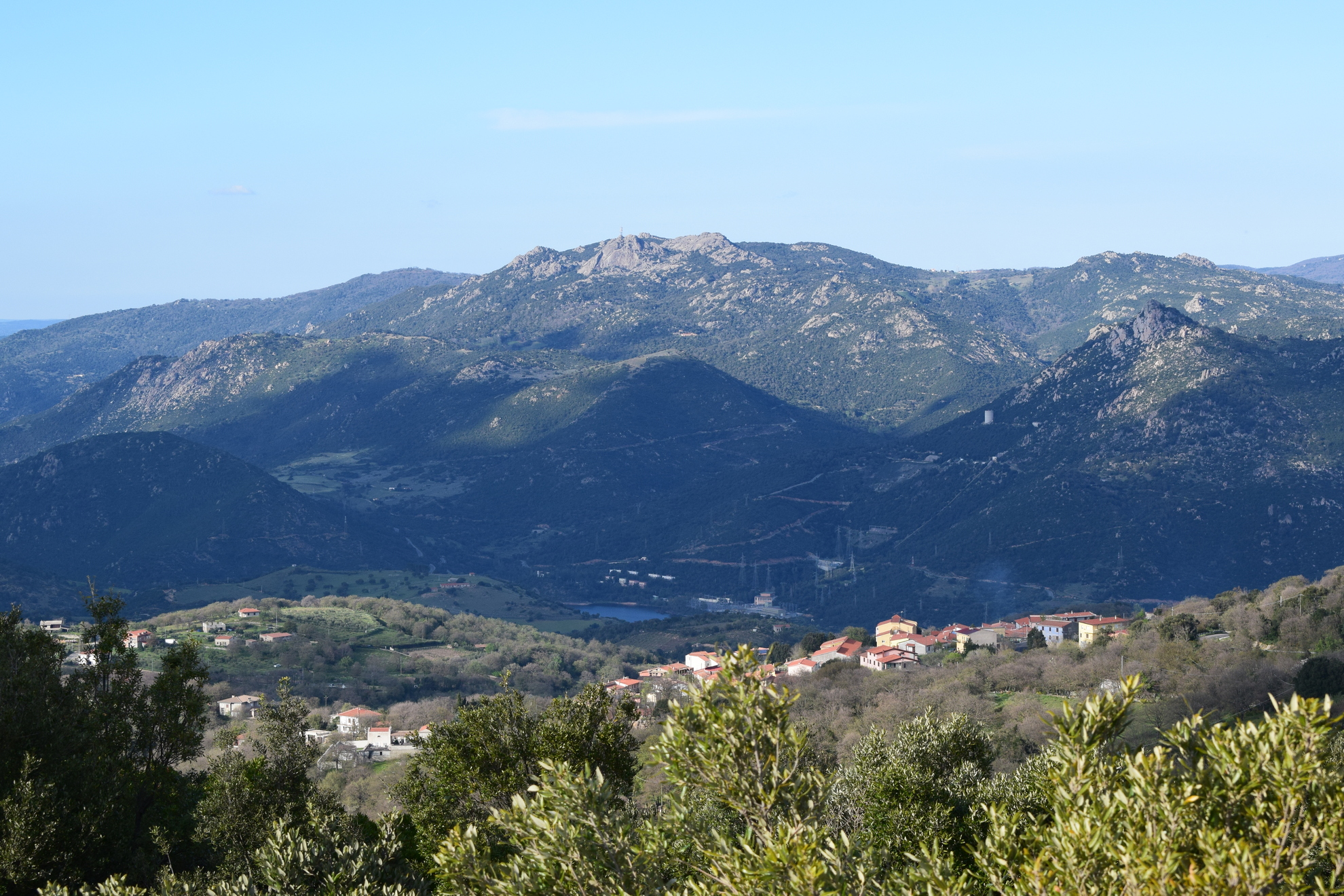
In the heart of the Barbagia di Belvì, stretched out in a valley at the foot of the Gennargentu mountains, it is surrounded by enchanting landscapes. Its strategic position up in the cooler hills made Aritzo a summer retreat already in the XIX century, blessed as it was with clean healthy air and the fresh pure water that gave it its name: the source of is Alinos and the funtana de sant’Antoni spring, known for its very pure water.
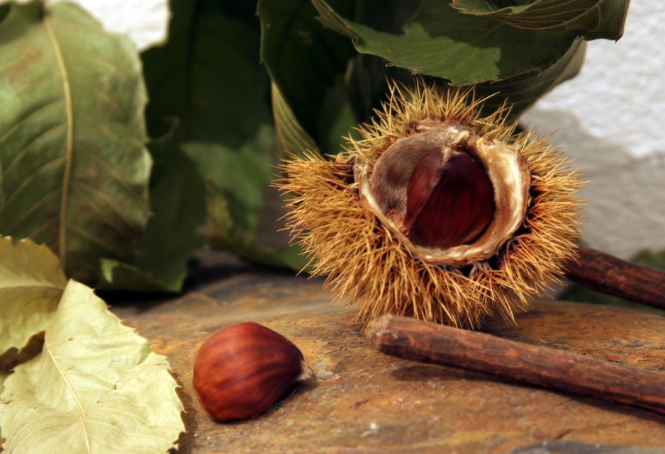
The fine wood from the infinite stands of walnut and chestnut trees gave origin to local crafts. The town is especially famous for its characteristic nuptial trunks, known as cascie, and cutting boards, made using traditional carving techniques. And wood is also used for balconies, which are a soft pink colour and stand out from the stone walls of the houses.
Since the early 1900s, the so-called “snow trade” flourished on the mountains around Aritzo, an activity that marked the town’s history. Ice was gathered into crates lined with insulating straw and then sold during the hot summer months. You can still admire the remains of the domos de nie, the old snow pits, where the niargios preserved their frozen merchandise. The first of these deep pits date to the XVIII century. They would be carefully insulated so that the ice could be sold to various cities on the island in summer. The ice was used until the first half of the XX century to make Aritzo’s typical dessert, sa carapigna, a delicate lemon sorbet especially enjoyed during a local festivity on the second Sunday of August, and at many other summer events.
When you go to Aritzo, stop in to see the XVIII century Spanish prison, now converted for use as gallery space for Bruxas, an exhibition about magic, witchcraft and the Holy Inquisition in Sardinia. Other buildings not to be missed are the fascinating casa Devilla, which dates to the XVII century, and the Arangino Castle, built in the early XX century. The chestnut festival is held during the last week of October, together with the many other Autumn in Barbagia events in Aritzo. The woods surrounding town are wonderful for hiking or horseback riding excursions to the peaks of the Gennargentu, while in the upper Flumendosa valley you can go canoeing. Not far from town is a natural monument that should not be missed: Texile, a rocky dolomitic outcrop that resembles a mushroom.
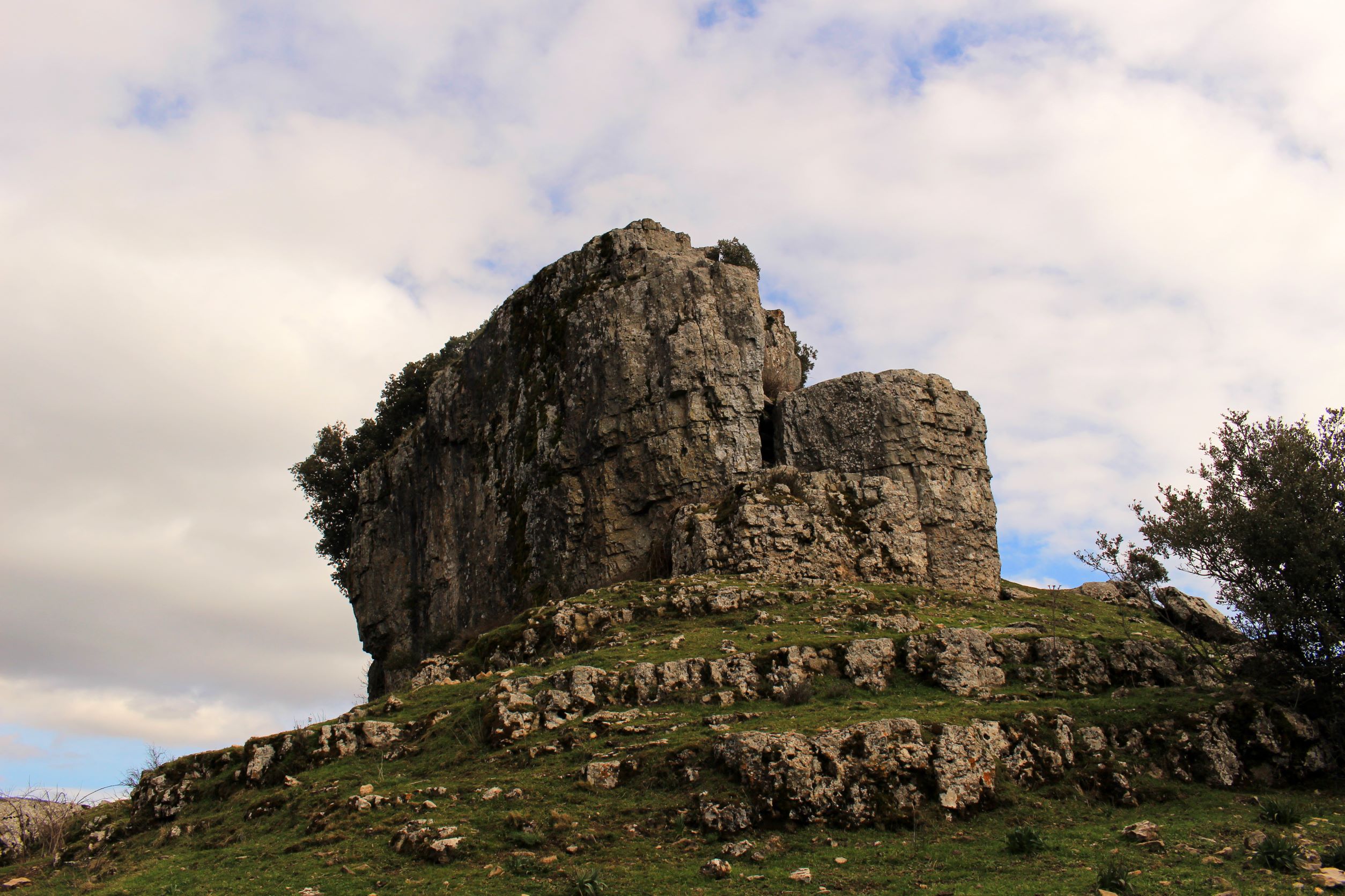
Su Texile
A cylinder of limestone surmounting a cone of schistose rocks, forming a curious natural geometric shape set at almost a thousand metres altitude, stands solitary among wooded hills. Su Texile, also known as su meseddu de Texile, is a taccu: a typical ancient rock formation, and a natural monument since 1989, as well as a symbol of Aritzo, a mountain village nestled in the Barbagia di Belvì area. Composed of Mesozoic limestone and dolostone, it covers an area of almost one hectare, is 24 metres high and between 50 and 70 metres wide. You can reach it from the outskirts of the town, two kilometres along the road to the Cossatzu cantoniera, amid a picturesque landscape with its pastures, remains of an oak wood, chestnut trees, hazels, cherry, and walnut trees. You will suddenly come across a view that you will not forget and you will understand the observation of Vittorio Angius, 19th century historian: "from afar, the top resembles a perfect cylinder, but up close it reveals an irregular shape".
Tezile, a barbaricino word of pre-Roman origin, indicates an isolated hillock, while meseddu, diminutive of Spanish mesa (table), and indicates a stool carved from a trunk: the two terms refer to the shape of the rock as it appears perched on top of the cone-shaped hill. The strange shape of Texile is characteristic: it looks like a giant chipped mushroom, with edges more eroded at the base than at the top. It has flat, vertical, steep walls and karst cavities. In the fissures, holm-oaks have settled - unusually at these altitudes - and pre-Quaternary flora have found refuge, different vegetation compared to the surrounding areas of the Gennargentu. Su Texile is one of the witnesses, spared from erosion, of the calcareous covering of the Giurese area that stands out along the western 'depressive' edge of the mountain massif. The morphology is similar to that of neighbouring hills, such as the Tònneri di Belvì and Tonara.
The monument is also called sa trona de Santu Efis: according to popular belief, this is where Sant'Efisio preached the faith to the barbaricini. Another legend mentions it as home to sa musca maccedda, a killer insect. The position of the Aritzese taccu has attracted attention ever since prehistory: it is surrounded by Neolithic remains, including the domus de Janas of rio su Fruscu, Baccu'e Forros, su Furreddu'e Carraxioni and Tonitzò (in the territory of Belvì). The nearby nuraghes of on Nuracciolu and on Nuraxi Liustra date back to the Bronze Age, and the latter is connected to a Giants' tomb. Recent excavations have brought to light remains of walls, embedded in the eastern side of the taccu: inside were found fragments of nuragic ceramics and pottery from the Imperial Roman period, indicating the continuity of use of the site. Near the Texile was also found a treasure trove of Roman coins (1st to 2nd century AD), now kept in the GA Sanna museum in Sassari. In the territory of Aritzo, do not miss the domos de nie ('neviere') of Funtana Cungiada (1300 meters altitude): deep wells dating back to the 17th century, which have fuelled the town's historical snow trade for centuries. After the nature trip, take time to admire the historic centre and monuments: the charming Casa Devilla, Arangino castle, the parish church of San Michele, the 17th century Spanish prison and the ethnographic museum of the Sardinian mountains. Aritzo is famous as the 'capital of chestnuts' and for its maistos 'e linna, wood carving craftsmen.

Laconi
A green oasis inside the village, unique evidence of prehistoric times, community values. The village of Laconi is a 'gem' with two thousand inhabitants, nestled in a forest, next to the Sarcidano hills, which boasts the Bandiera Arancione (Orange Flag) of the Italian Touring Club. Its original fame is linked to the most beloved Sardinian saint, St Ignatius: veneration of this saint attracts tens of thousands of pilgrims, especially during the festivities at the end of August. The visit begins at the house where he was born. This, along with the museum of sacred art and the parish church dedicated to him and to St Ambrose, built in the 15th century and modified several times in the nineteenth century, are stages of a devotional journey in the old town centre. In the village, there are also the churches of San Giovanni Battista, with wooden sculptures supporting the roof, and of Sant'Antonio Abate, in honour of whom fires are ignited in January, accompanied by the Feast of Traditional Pastries. At the end of the year, the ancient houses and noble villas are opened up during the event known as Ocraxus.
You will admire an open air museum: the first traces of human presence date back to 6000 BC. Between the end of the Neolithic era and the beginning of the Metal Age (3700-2400 BC), a unique sculptural phenomenon developed: the Menhirs. You can admire them in the Civic Archaeological Museum of Prehistoric Sculpture, located in the ancient Palazzo Aymerich. Inside it, there are 40 sculpted monoliths, dating back to a period between the 4th and 3rd millennia BC, some of which are gigantic. Eight monoliths have been found in Perda Iddocca, six Menhir-statues in Pranu Maore. The museum itinerary is completed by ceramics, objects made of obsidian and metal, discovered in other sites in the Sarcidano region, among which the megalithic tomb of Masone Perdu and the Dolmen of Corte Noa. The Nuragic civilization is represented by Nuraghe Genna 'e Corte: a central tower and bastion with five towers, of which only two still remain.
Laconi is a paradise for botanists, with forests and the habitat of rare mammals and birds. It is an area rich in truffles and can count the highest number of orchids on the Island. The Aymerich park stands out and is a short walk from the city centre. It is organized around the remains of the Aymerich castle, the name of which comes from the last Laconi nobles, although it had emerged earlier. The main tower, of the 11th-12th century, became a prison in the 18th century. The castle is divided into two floors: the lower floor contemporary with the tower and the top floor with Catalan-Aragonese windows and mouldings. It has a prestigious portico. The marquises were responsible for the layout of the garden of exotic plants and then of the holm oak forests: you can admire a Cedar of Lebanon, a weeping beech tree, the Corsican pine and the southern magnolia. The greenery is punctuated by caves, streams, little waterfalls and lakes, which you can reach along paths. The district of Santa Sofia, where there are the remains of a Byzantine church, is worth visiting. At the end of June, the 'Sarcidano' horse show takes place in the oasis. It is an ancient, indigenous breed and there are about one hundred specimens still present.
Bitti
Bitti is the main town of the northern Barbagia region and it was once known as Barbagia di Bitti. The raising of livestock made this area an important centre of dairy production (especially sheep milk products), a tradition that is the focus of the local Farming and Pastoral Museum set up in a traditional landowner’s home in the centre of town. One of its sections, the Multimedia Museum of Tenore Singing, celebrates the characteristic polyphonic folk singing that has made Bitti famous the world over. Here you will find the best preserved legacy of this ancestral singing technique, the most authentic relics of the archaic roots of Sardinian culture that were passed down from father to son over centuries of improvised poetry, relics that echo lives spent in fields, herding sheep and working wood. The cultural importance of this type of singing was internationally recognized when the tradition was included on the UNESCO List of Intangible Cultural Heritage.
The town is a member of Italy’s Most Authentic Villages Club and sits at an altitude of 500 m above sea level in a valley surrounded by mountains. First mentioned in documents in 1170 as Bitthe, it’s real history reaches back to time immemorial and although its nucleus dates to the Roman Era, man settled here as far back as prehistoric times. The sanctuary village of su Romanzesu is tangible proof of this: the size, complexity and architectural originality are an invaluable legacy of ancient Nuragic civilization. It spreads out over seven hectares on a plain nestled in woods 13 km from Bitti and contains some one hundred huts, a variety of temples, a water well and mysterious labyrinth, all made of granite. Its name derives from a later Roman settlement from to the II-III century BCE.
The large, low, stone houses of Bitti are set amphitheatre style and the streets that pass between them are narrow. Some thirty thousand people live here and the town nestles around the Church of St. George the Martyr. There are countless churches in the town and in the surrounding countryside, many devoted to the Virgin Mary. Some of the ones worth visiting are: the Church of the Madonna dell’Annunziata, celebrated on the third Sunday of May, the Nostra Signora del Miracolo, celebrated on 30 September, and the Church of the Santissimo Salvatore, celebrated on 6 August. Events not to be missed include the Bonfires of St. Anthony on 16 January and Holy Week, especially the s’Iscravamentu on Good Friday and the s’Incontru on Easter Sunday. Among the various monuments in the centre of town, the legendary su Cantaru fountain is sure to fascinate you.
Belvì
Clinging to Mount Genna de Crobu at 660 metres above sea level, between spectacular limestone outcrops to the west and the foothills of the Gennargentu to the east, its immense wealth lies in its natural heritage. Belvì, an agri-pastoral town of 600 inhabitants, is surrounded by endless, fairy-tale woodland: forests of holly, chestnut, cherry, homo oak, hazelnut and downy oak trees, with juniper and olive trees growing in the rocky areas. In folk tradition, the forests are inhabited by legendary beings: the Masaschinganna, who scare anyone who enters, and the janas, who spend the daytime weaving domus dug into the rock (in reality, pre-Nuragic burials) and the night-time wandering through the woodlands. In the midst of the lush forests is the Su de Maccioni oasis, Punta Tonnai, the Pitz’e Pranu pine forest (with adventure park) and the Uatzo Forest (with picnic areas), crossed to the north by the Trenino Verde railway.
The tourist railway stops off in the old station of Belvì, followed by a panoramic curve with views over the surrounding valleys. Uatzo is the starting point for marked trekking paths: during the itineraries, you can catch a glimpse of eagles and falcons, and hear the crash of mountain springs and streams. There are also plenty of prehistoric sites: the Giant's tomb of Troculu, rebuilt on the Nuoro-Lanusei state road, with a funerary chamber in blocks of granite and exedra with a staired wall, and on the su Pranu plateau, the vast Cuccuru Nolza complex with Nuraghes, built with a four-cornered keep and bastion, and surrounding village.
In the past, the town was the main centre in the area, known as the Barbagia di Belvì. Not under the dominion of feudal lords, up to the mid-18th century it was governed by a representative chosen from among the main families. Its symbol are the unique caschettes, handmade pastries (from the 17th century), once reserved for ceremonies (the bride's pastries), made from violada pastry and filled with hazelnuts and honey, flavoured with orange, that can also be tasted during the town's part of the Autunno in Barbagia event. In the town centre, which still has the original narrow, winding paved or cobbled streets, along with examples of traditional rural architecture, you can visit the parish Church of Sant’Agostino, patron saint celebrated in August, and the Natural Science Museum where you can admire around a thousand specimens of (Sardinian) minerals and 300 fossils, dating from the Paleozoic and Quaternary periods, with arachnids, coleoptera, hymenoptera, lepidoptera and more (including exotic butterflies), around 400 species of Sardinian birds, including extremely rare birds of prey, and 70 mammals, 200 types of marine seashells, madrepores and crustaceans. The museum closes with amphibians, reptiles and fish, with a giant ‘Caretta caretta’ turtle. Other religious buildings include the churches of San Sebastiano and Santa Margherita, celebrated in early June. In the same period, the Cherry Festival is held along with a craft skills show, where you can discover the art of wood carving and iron-working.

Necropolis of Sant'Andrea Priu
With 18 rooms, one of its underground burial sites is among the most extensive in the Mediterranean. The Pre-Nuragic necropolis of Sant'Andrea Priu is located on a plain less than ten kilometres from Bonorva and 500 metres from the rural church of Santa Lucia. In the vicinity, there is also the spring of Lumarzu and the Nuraghi Puttu de Inza and Monte Donna. The burial complex is made up of twenty Domus de Janas dating back to the Neo-Eneolithic age (4th-3rd millennium BC), dug out of the wall and on the plain of a trachyte outcrop 10 metres high and 180 metres long. Inside them, architectural residential details have been reproduced to recreate environments similar to the house of the deceased person. Recognised for its outstanding historical and archaeological significance, since 2025 it has been one of the seventeen pre-Nuragic necropolises in Sardinia listed as a Unesco World Heritage Site.
Three domus in the necropolis will amaze you with their sizes and state of preservation. The 'Tomba del Capo' (tomb of the Head) has an extension of 250 square metres and contains 18 rooms arranged like a maze around two main spaces. An entrance leads to the semi-circular anteroom (seven metres in diameter). The two cells at the back are rectangular and arranged in longitudinal succession. On their walls, little rooms open up and lead to numerous secondary cells with niches and counters. The 'Tomba a Capanna' (Hut Tomb) is round (three metres in diameter) and can be entered via a rectangular space. The two rooms have votive cupules: three in the anteroom and 15 in the main cell. The ceiling is decorated by a sunburst of grooves carved in the rock: they allude to the roof trusses of the eneolithic huts. The 'Tomba a Camera' (Room Tomb) reproduces the architecture of a dwelling: an entrance pavilion leads to the main room, which is rectangular. The second space has two pillars and a ceiling that depicts a double pitched roof. Other burial places show symbolic elements: on the floor of a smaller tomb there is a hearth with a raised circular ring. Above the ridge where the tombs are located, you will see a majestic and unique rock known as 'the bell-tower'. It has also been named 'sacred bull' because of its shape: it was thought to be a monumental sculpture but, in reality, it is a trachyte monolith shaped by the weather.
The necropolis was reused for a long time. In the Roman age and then the Byzantine age, the 'Tomba del Capo' was turned into a rural church built into the rock, one of the first during the period of the persecutions. It has been plastered several times and frescoed with scenes from the New Testament, which you will notice inside it, and it was named after Sant'Adrea (Saint Andrew), which is where the name of the site comes from.