

Osilo
It is located at an altitude of almost 700 metres in the northernmost of the three peaks of Tuffudesu, dominated by the Malaspina Castle, dating back to the end of the 12th century, of which you can admire two towers and perimeter walls. Osilo, a village with three thousand inhabitants, is the second highest Municipality in the province of Sassari. It has medieval origins and was a very important village until the early 20th century. Its artisan traditions are still alive and well, especially textile products and agricultural and pastoral produce: it is the home of Pecorino cheese. Another delicacy is the casadinas (formaggelle), made with a soft cheese filling. In August, little cobbled streets, stone houses and historical buildings (like the Palazzo Civico built in 1600) come to life with Artes Antigas, a revival of ancient trades and traditional culture, and with the of Corsa all'anello, an equestrian joust where the knights, in traditional costume, catch rings, suspended along the track, on their lances, while galloping.
Osilo boasts an exceptional number of churches: 36. Churches that stand out include the parish church of the Immacolata Concezione (end of 17th century), with a multi-coloured marble altar and a seventeenth century wooden choir, and the little church of San Maurizio, in Gothic-Catalan style (17th century), with a tuff altar that guards the statue of the saint in a painted niche with a sculpted shell. Santa Ittoria 'e Sa Rocca was restructured in 1731 with a Renaissance façade and a curvilinear shape. In the old town centre, stands Nostra Signora del Rosario (17th century), an example of late-Renaissance art with Gothic details. Not far away, there is the church of Babbu Eternu, perhaps the most ancient in the village. In the outskirts, there is Sant'Antoni 'e Sa Punta (17th century). Not to be missed, is Nostra Signora di Bonaria, on the peak of Mount Tuffudesu, at a height of 800 metres: from here, you can enjoy a view that reaches as far as Asinara. It was a symbol for sailors, as it is one of the first points to be spotted from the sea. Lastly, there are the churches of San Giovanni Battista, Santa Lucia and San Lorenzo, which was mentioned as early as 1688 but renovated at the beginning of the 20th century. The little church is located in the district of the same name, inside the valle dei mulini (valley of mills). Here, the limestone rock features sudden vertical drops that make it possible for the water to flow forcefully and it has, in fact, always been used: in the middle of the 19th century, there were 25 active mills. Today, they are in a state of disuse and can be visited. In the precipices of Mount Tuffudesu and of the rest of the territory, there are more than thirty rock-climbing routes. As well as a destination for rock-climbers, the area is also popular with mountain bike enthusiasts, thanks to hills, mule tracks and winding roads. The territory is scattered with traces of human presence since the Neolithic era: the eight Domus de Janas tombs of Ittiari and the three of Is Scalas, two Tombs of the Giants and about ten Nuraghi, among which Sa Pala 'e Su Cossu.
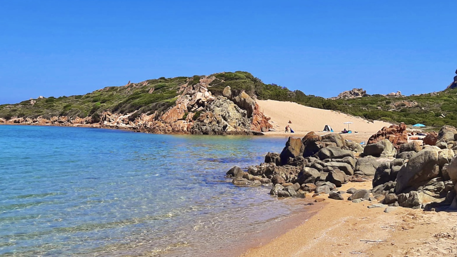
Monti d'A Rena
This ten-metre-high dune looks like a soft, white mountain. From its left side, the stretch of sand gently slopes into the crystal clear sea with its shades of blue and emerald green. It is the landscape that awaits you on the beach of Monti d'Arena, in the northern part of the island of La Maddalena, enclosed between Punta Abbatoggia and Punta Marginetto, shortly before you reach the tourist village of Punta Cannone.
The name, in fact, comes from the distinctive 'mount' of fine, white sand surrounded by thick Mediterranean scrub. The waters are shallow and the seabed is sandy, with rocks sticking up here and there, made of granite, the true protagonist of the area. Crumbled into small grains and shaped by the northwesterly mistral wind, it forms large deposits of sand that make Monti d'Arena unique.
The beach also has a small pond behind it, where animal species typical of the Mediterranean area live. Furthermore, it is equipped with a place for dining and refreshments, ample parking and bus links. You will be able to rent pedalos and boats. Thanks to the constant wind, this destination is popular with windsurfing enthusiasts.
In the vicinity, in the northern part of the Maddalena, don't miss a chance to enjoy another two beaches with very similar features: Bassa Trinita and Cala Lunga, made up of rocks shaped by the wind and soft dunes. The entire coastal perimeter of the island will captivate you with its cliffs, inlets and little coves. On the opposite side, in the southwestern area, you will find the sparkling colours of Punta Tegge. Going back along the western coast, there are the hidden bays of Cala Francese. To the east, not far beyond the isthmus that connects La Maddalena to Caprera, where there are multiple natural and cultural attractions, you will find the charming scenery of Spalmatore. Moreover, from La Maddalena, you can set out to discover the other islands of the national park: Santo Stefano, Budelli, Razzoli, Saint Maria and Spargi.

Tuttavista
On its peak, which is over 800 metres high, stands a bronze statue of Christ, a work of art created by an artist from Madrid, Pedro Angel Terron Manrique. The sculpture is twelve metres high and it is a reproduction of the wooden statue of the holy Crucifix located inside the church of the same name in Galtellì. Thanks to the symbolic presence, Mount Tuttavista, it is a destination for pilgrimages for those who wish to meditate in a secluded place in contact with nature, along a captivating trail that climbs its slopes.
The mountain is located in Baronìa, in the territories of Galtellì, Onifai and Orosei. Its sides are delimited by the alluvial valley of the Cedrino river. From the peak, you can see a 360 degree panorama of the surrounding territory: to the south, there is Dorgali with mount Irveri, to the west the Cedrino river, Galtellì, Loculi and Irgoli, to the northwest the long Monte Albo mountain range and to the east the Gulf of Orosei. Travelling along the scenic road, up the slopes and along the hairpin bends, you will stop numerous times to observe breathtaking landscapes: the name of the mountain, Tuttavista (meaning 'all view'), is a guarantee. Stopping at 635 metres of altitude is a must: here, you will find a natural monument, Sa Preda Istampada (the pierced stone), a rock face in which there is a hole of 40 metres in diameter created by the wind and rain, practically a window onto the valley below and Supramonte. You can also try your hand at trekking trails, like the one that climbs the mountain from the area of Taraculi.
The limestone rock of the Tuttavista has a rugged morphology, with grottoes and Karst caves where fossils of wildlife and endemic species that lived between ten thousand and two million years ago have been found. Holm oak forests, junipers, mastics, spurge and 32 types of wild orchid - rare endemic species that you can photograph along the trails - bring colour to the mountain. The vegetation is populated by wild boars, weasels, martens, foxes and various bird species: common ravens, kestrels, partridges and buzzards. This natural oasis is also ideal for free climbing enthusiasts: there are various rock faces equipped for climbing, with medium and high difficulty paths.
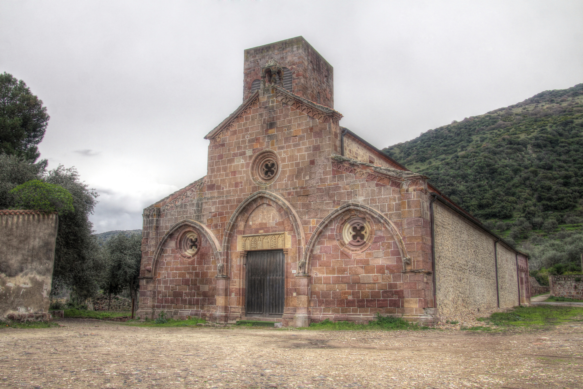
San Pietro extra muros - Bosa
From the colourful houses in the village of Bosa, travelling one kilometre along the Temo river, you will reach the locality of Calamedia, a site that was already inhabited in the Phoenician-Punic age: here, you will find the cathedral of San Pietro, the most ancient Romanesque church on the island. Its red trachyte walls stand near the river banks, on the opposite shore of the hill of Serravalle, dominated by the castle of Malaspina, inside of which you will find another gem of religious architecture: Nostra Signora di Regnos Altos (Our Lady of Regnos Altos). The cathedral of San Pietro is said to be extra muros because it is located outside the castle walls and it is more than half a century older than the castle itself. Around it, there was the original nucleus of the town, which was inhabited until the end of the sixteenth century. When the district of Sa Costa was later completed on the hillside, the population moved. The migration took two centuries: Bosa vetus disappeared.
The sanctuary is the result of a long process. The most ancient part dates back to the 11th century, as is confirmed by the epigraph of its consecration, which refers to the year 1063, while the tribune with a new apse, bell-tower (24 metres high and unfinished) and perimeter walls were created the following century. The overflowing of the Temo river compromised some parts, which were rebuilt in the middle of the 20th century: the complex regained its Medieval appearance. Today, you can admire a church that, despite losing its title of cathedral, has managed to keep its charm intact. The façade (dating back to the 13th century) is decorated with large arches and also with small intertwined arches. On the top, you will notice an aedicule, supported by little columns, with a snake wound around them. The portal is framed by an arch, over which you will be struck by an architrave sculpted with fake loggias and six little arches with bas-reliefs depicting, in a hierarchical composition, the Virgin Mary with Child in the main central aedicula, next to which there is the Tree of Life and a holy bishop (possibly Costantinus de Castra, who consecrated the building), on the right side, there is Saint Peter and on the left Saint Paul, wearing robes with elaborate drapery. The bishop is in the smaller aedicula but he is given a place next to the Virgin Mary. The apse is divided in to five sections by lesenes supporting corbels that, in turn, support little arches. In three of them, you will see single-light windows that help light up the interior, made up of three naves: the middle one is covered by wooden trusses, while the side ones have cross vaults. You can access them via nine rounded arches on each side, supported by quadrangular pillars. In the first one on the right, you will see a white limestone baptismal font.
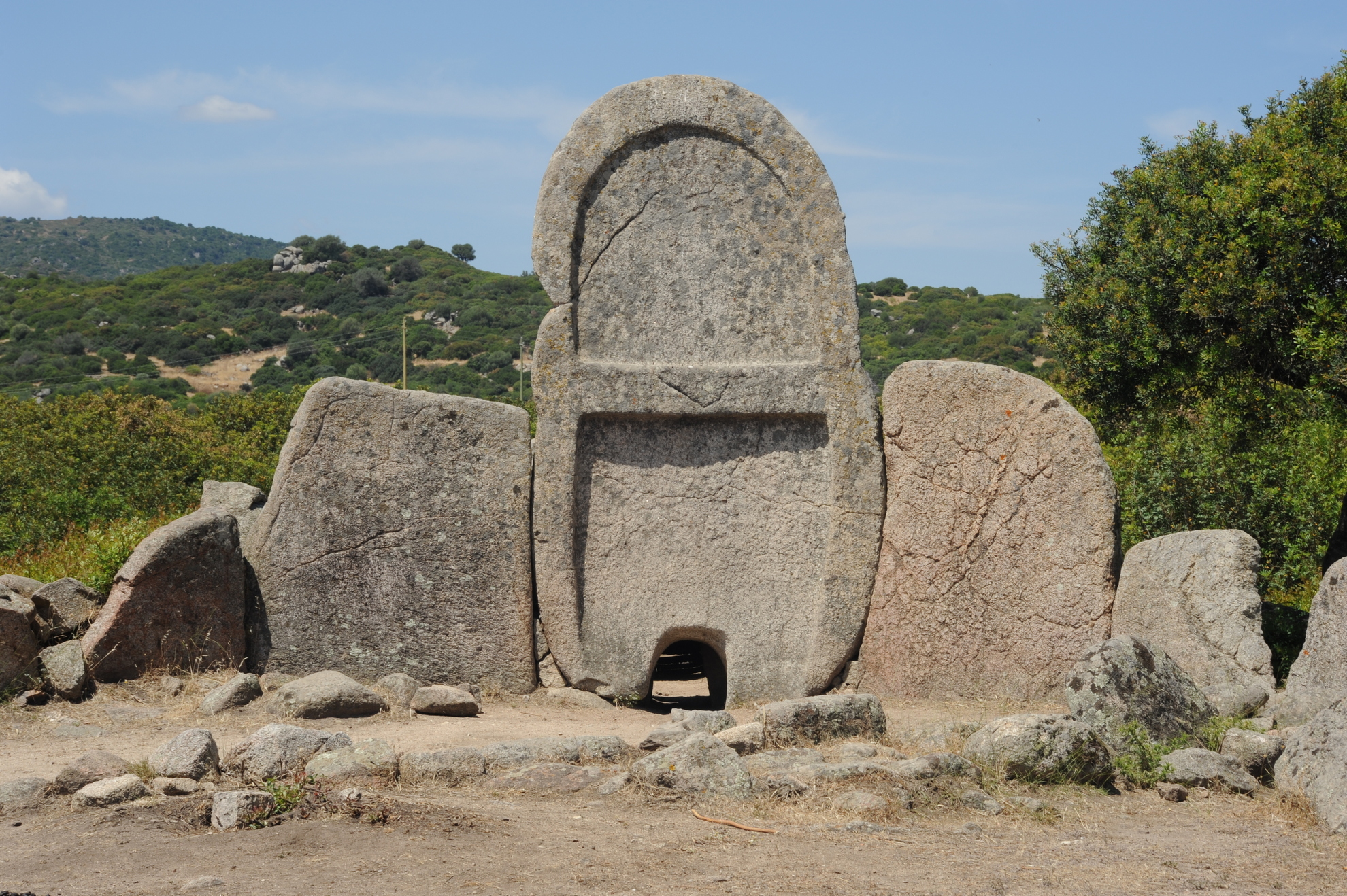
S'Ena e Thomes
You will see its enormous stele, a granite slab almost four metres high, standing out in the valley of the Isalle rivulet, at the end of a trail half a kilometre long and covered in Mediterranean scrub. The Tomb of the Giants of S'Ena 'e Thomes is the most important Nuragic burial monument on the island: it is majestic, just like it was thousands of years ago. Dating back to the Early Bronze Age (1800-1600 BC), it is located in the Dorgali territory, six kilometres from the Nuragic village of Serra Orrios and approximately 17 km from the residential area, along the road that leads to Lula.
Your impression will be one of archaism and monumentality. The granite stele with smooth edges weighs seven tonnes and is at the centre of an exedra, or a semicircle of stone slabs 'laid on edge' set in the ground in the shape of a bull's horn, decreasing in size from the centre outwards. They delimit the sacred area, where ancestral funeral rituals were officiated. A symbolic little door has been carved out of the stele, giving access to the gods of the underworld, and is so small that it is inaccessible to living beings. Behind it, almost intact, there is the dolmen funerary corridor, 11 metres long, with a jack arch roof: the stone slabs are arranged horizontally along the walls. The mortuary is facing south, which is unusual compared to the 'eastern' facing ones in many other Nuragic tombs. This is true also in the burial sites of Goronna (Paulilatino) and Baddu Pirastru (Thiesi). According to legend, the tombs of the giants were used by huge beings: the gigantic size make the origin of the name clear. In reality, they were collective burial places. S'Ena 'e Thomes also confirms the fact that, for the Nuragic people, death made no distinctions: during the excavations, the meagre grave goods that were found do not point to any social disparities. The doubt about whether it was a mass grave or one reserved to a single class (aristocratic) still remains. They are also considered places that emit energy: researchers, spiritualists and people who are curious visit them, seeking physical healing or spiritual regeneration. In the ancient ritual, also widespread in Greek culture, a person would fall into a trance, thus entering into contact with the divinity.
Monastir
The name apparently comes from muristenes, an ancient dwellings for worshipers and traders, or from the Catalan word for monastery. It is not by chance that since the end of the 20th century, near the parish church of San Pietro Apostolo, there was a building known as domu de is paras, 'house of the friars'. Monastir is located on the fertile Campidano plain, between two little hills of volcanic origin, Mounts Zara and Olladiri, which break up the flat trend of the countryside through which the Riu Mannu and Riu Flumineddu rivers flow. This municipality has four thousand 500 inhabitants and is situated twenty kilometres from Cagliari. It has an agricultural vocation: citrus fruits, peaches and potatoes are grown all over its territory.
The present-day village emerged in the Middle Ages around a community of Camaldolese monks. It was part of the Calari Giudicato and, for a short period, that of Arborea, after which it became the property of Pisa. The remains of the Baratuli Castle are an emblem of that period and stand on top of Mount Olladiri. The castle was built in the middle of the 12th century by the Giudici (rulers) of Cagliari, after which it passed to those of Arborea and was destroyed by the Pisans at the beginning of the 14th century. The old town centre extends around the parish church of San Pietro, the patron saint of the village and its Gothic-Aragonese structure dates back to the beginning of the 16th century. The church of Santa Lucia is much older (second half of the 13th century) and it is a Romanesque style church. At the end of August, the celebration in honour of the saint takes place: this is the moment felt most deeply by the community of Monastir, with processions to and from the parish church and the little rural church, accompanied by worshippers, knights, wagons pulled by oxen, groups in costume and launeddas players. The first celebration of the year is that of the Fires of Sant'Antonio Abate (17 January) to whom a 14th century Gothic church is dedicated. Next, a few days later, there is Su Foghidoni for St Sebastian. A 15th century sanctuary is named after him. In this extremely devout village, other religious buildings stand out: the church of San Giacomo, which is the most ancient (12th century) and is embellished with a spiked bell-tower, and the church of the Beata Vergine Maria (or of the 'Madonnina').
Monastir boasts a remarkable archaeological heritage. The oldest evidence is in the hills: in Is Aruttas, a Domus de Janas necropolis (3200-2800 BC), on Olladiri there are the remains of Pre-Nuragic and Nuragic huts, on the Zara there are the Domus de Janas known as Is Ogus de Monti and the monumental flight of 60 steps dug out of the rock, which lead to the acropolis. At the top of the hill, you will see the sacred Nuragic area, two altars and two wells used for worship of the water deities. At the bottom of the steps, there is a 9th century BC circular building, used for various activities, including wine-making. In the area, there are is also the Su Cuccumeu Nuraghe and the village of Mitza Morta.
Gesturi
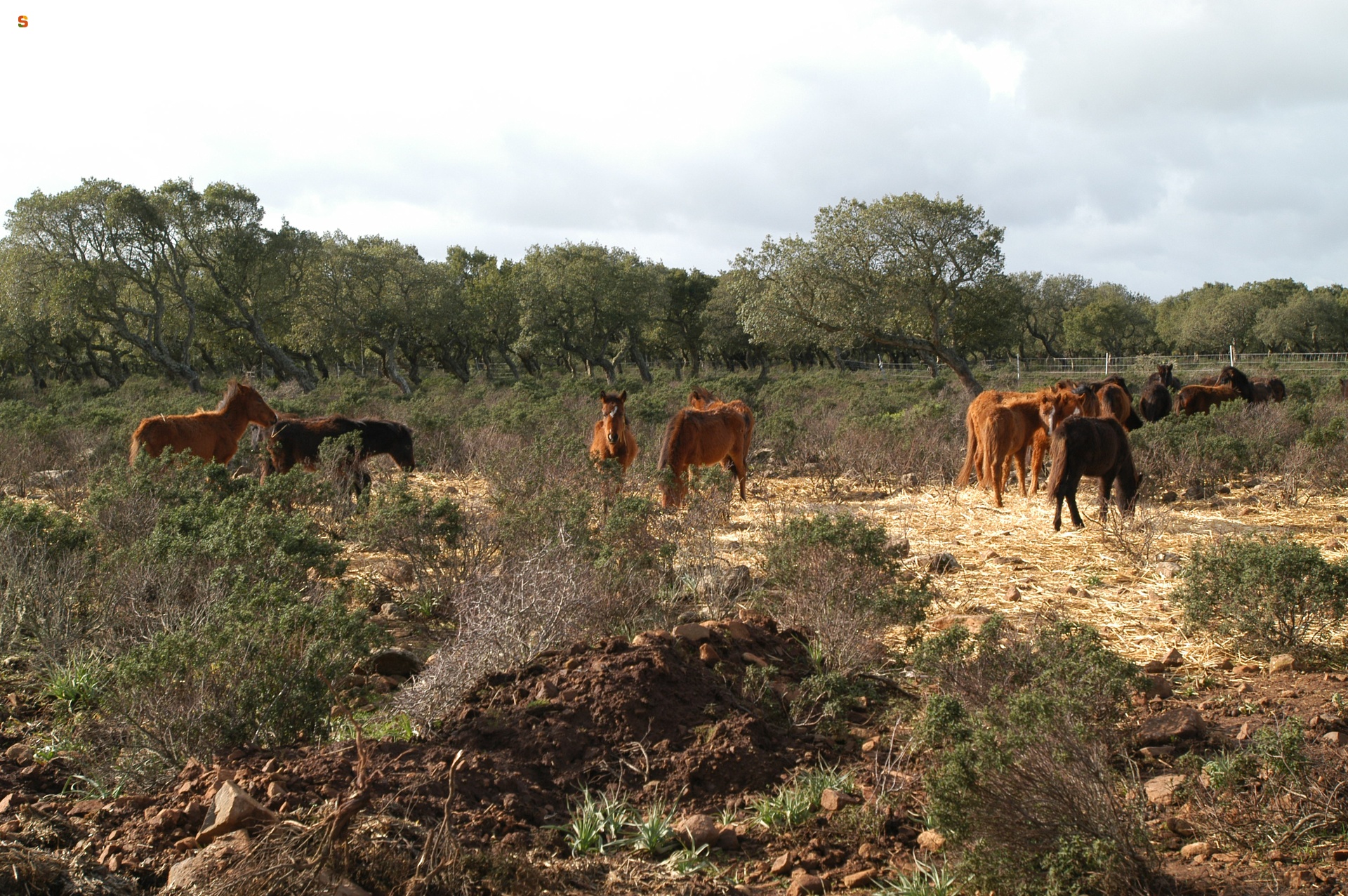
An enchanting landscape where time stands still, a Nuragic legacy and intense devotion. These are the characteristics of Gesturi, the northernmost village in the Marmilla region, with over a thousand inhabitants. Its territory partially occupies the Giara (sa Jara Manna), a plateau 600 metres high, once an impressive volcano and now an unparalleled oasis in the Mediterranean. Vegetation and animals live in symbiosis: a 'natural museum' with a dense blanket of botanical species, rare flowers and plants that adapt to the climate and the territory. They receive moisture from Is Paulis, enormous pools of water, even four metres deep. All around, there are valleys dominated by Mediterranean scrub and hills on which there are olive groves and vineyards, from which excellent quality wine and olive oil are obtained. Then, along the precipitous ridges of the plateau, forests of oak trees and poplars appear and make way for the cork oak woods on top of the plateau, almost all of which are 'crooked', having been bent by the strength of the wind.
This wildly beautiful place is inhabited by ducks, Eurasian woodcocks, Eurasian jays, hares and, above all, Giara horses, a protected species whose origin is shrouded in mystery and of which there are about 500 specimens living in small groups. Rocky elevations stand out on the plateau, interrupting the level trend of the ground. Here, you can walk amidst the signs that man has left over 3500 years, including the 'father of all Nuraghi', the Bruncu Madugui Protonuraghe. There are thirty archaeological sites, among which the Menhirs and Domus de Janas of Sa Ucca 'e Su Paui, the Tombs of Giants and Nuraghi of Pranu 'e Mendula and the Punic and Roman villages of Tana and Tupp'e Turri.
Gesturi is a destination for pilgrimages, thanks to Fra Nicola (1882-1958), who was beatified by Pope John Paul II and who lived in a modest house in the little village, currently used as a museum. From here, you can follow an itinerary along narrow roads with dwellings that have portals and archivolted verandas, churches in the old town centre and rural sanctuaries. Devotion is expressed in six religious buildings: in the centre, you will see the bell tower standing out, 30 metres from the parish church of Santa Teresa d'Avila (1607), celebrated in mid-October. In the outskirts, you will find the church of Santa Barbara, the most ancient (1473), just outside the municipality. The Madonna del Rosario (17th century) is home to the Is Cunfrarius Biancus, a confraternity that, during Holy Week, is responsible for the Madonna. Taking care of the Christ is the task of the brothers of the Holy Sepulchre, who reside in the little church of Santa Maria Egiziaca, which is unusual because of its architecture and its 'dressed statues'. Four kilometres from the village, nestled in a forest of centuries-old trees, there is the church of Madonna d'Itria (1620), with its festivities that are possibly of Byzantine origin and begin on the first day of Pentacost. Along with these celebrations, there is also the lay feast of the sheep. The most heartfelt festivity is the one for Fra Nicola: two days of intense celebrations.
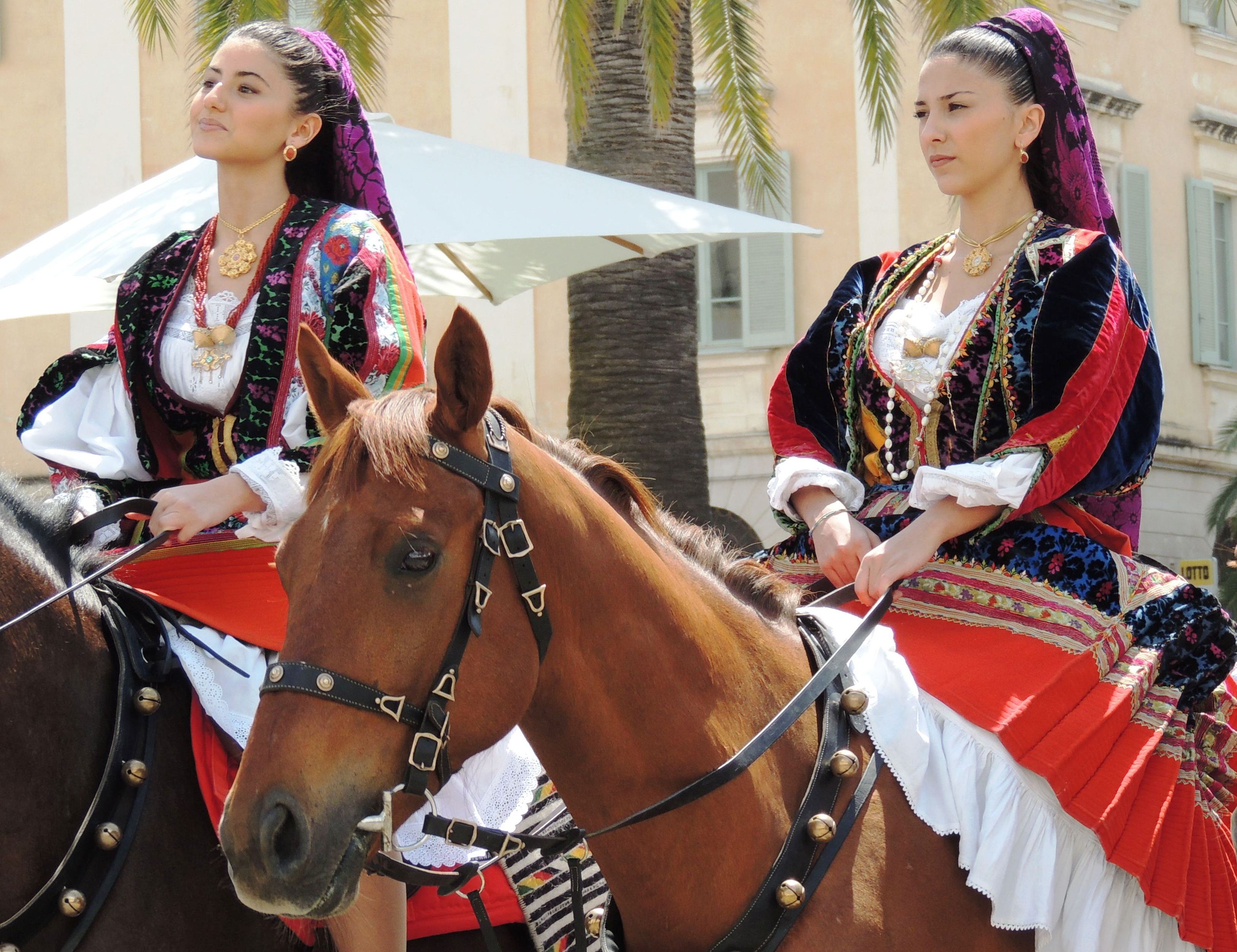
Cavalcata Sarda, the festival of beauty
The rhythm of the cantu a tenore singers takes turns with the thundering sound of the horses. Horesmen and Amazons offer breads, pastries and the first fruits of the season to spectators and Authorities. The rhythmic trot soon explodes into a daring race: the horsemen from Sedilo and the Sartiglia riders from Oristano. The Mamuthones of Mamoiada and the Boes and Merdules of Ottana captivate spectators and photographers with their fascinating and mysterious masks. The launeddas of the Sarrabus region accompany the procession and the final evening. These are the sounds and colours, music and dances, jewels and costumes of the Cavalcata Sarda of Sassari, where every year, on the second last Sunday in May, the unique identities of all the island communities meet each other. An unforgettable, rich show of majesty, a great spring festivity and the biggest lay event in Sardinia, now in its 74rd edition.
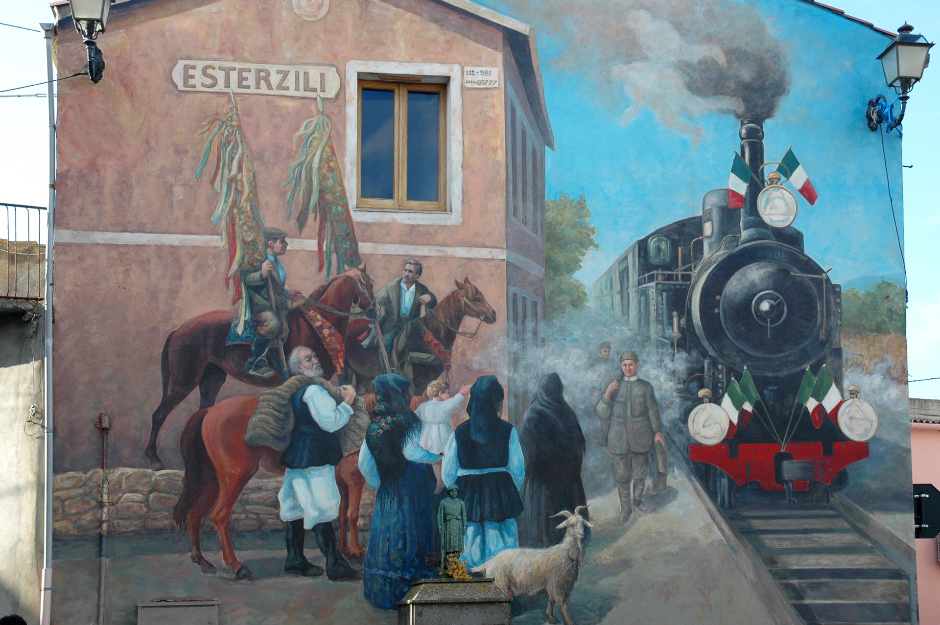
Esterzili
From the village, looking upwards, you will see the peak of an isolated and captivating mountain and then, looking towards the valley, you will be enchanted by the variety of landscapes. Esterzili is a small village with approximately 650 inhabitants located at an altitude of 700 metres on the slopes of Mount Santa Vittoria, the peak of which exceeds 1200 metres of altitude. From up there, at the end of a climb, you can admire a landscape that dominates Sarrabus, Gerrei and Sarcidano and that even stretches as far as Campidano and the Ogliastra sea.
From an administrative viewpoint, Esterzili comes under southern Sardinia, but it is considered part of Barbagia di Seulo. In the old town centre, the charm of the houses featuring murales is still intact. The village and the countryside are dotted with religious buildings. In the centre, there is the new parish church (1972) dedicated to St. Ignatius of Laconi. Inside the church, there is an altarpiece depicting Christ on the cross, a statue of the Virgin Mary of the Rosary (17th century) and an 18th century group of sculptures. The church of San Michele (15th century), dedicated to the patron saint, is a Gothic-Aragonese style church and it is located in the northern outskirts. In the refined façade, there is an inlaid main door and alongside it there is a belfry. The church of Sant'Antonio da Padova (17th century) is located on a hill at the northwestern end of the village. Nearby, inside the park of the same name, there is the seventeenth century rural church of San Sebastiano. Among the festivities not to be missed, in mid-August, there is the festival of Su frigadòri (onion bread baked in the oven) and that of Is cocoèddas (delicacies with a potato filling). Along with the flavours of the cuisine, there is folk music and shows.
The territory of Esterzili was inhabited as early as prehistoric times. 77 archaeological sites have been counted: Domus de Janas, Nuraghi, temples, Tombs of Giants and bronze statues. The most important one is the Nuragic temple of Domu de Orgia, perched at an altitude of one thousand metres. It is the most important megaron-type temple on the island, dating back to the second half of 2nd millennium BC: it consists of two rooms preceded by a vestibule and around it there is a sacred enclosure. During excavations, various bronze statues emerged. The most important evidence of the Roman period, one of the main ones discovered in Sardinia, is the Tavola di Esterzili, a sheet of bronze on which there is an inscription in Latin, describing the controversy between the peoples of the area, the Patulcenses Campani and the Gallilensi.

Palazzo degli scolopi
Along the axis that crosses the old town centre of Oristano, from the Tower of Mariano to porta Mari, lies one of most famous squares in the town, Piazza Eleonora d'Arborea, in which there is a wealth of important and religious buildings. Around statue of the Giudicessa, you can admire the Church of San Francesco d'Assisi, Palazzo Corrias Carta and, on the corner of Corso Umberto I, Palazzo degli Scolopi. In its place, states the historian Angius, there was one a synagogue, 'justified' by the presence of a substantial Jewish colony that, during Spanish domination, was forced to leave the Island.
Other news on the complex dates back to 1536-40, based on reports from the Council meetings that were held here during those years. The building then became the site of the Jesuit convent: the Scolopi, in 1682, opened an institute there, which was financed by a rich merchant. The Piarists occupied the lower floor of the convent and remained active until 1886, the year in which the religious orders were suppressed and replaced by the Regio Ginnasio. Today, the Oristano Town Hall is located here: inside it, there is the council room, with a sandstone entrance portal, and administrative offices.
The complex was renovated in 1830 by Fra' Antonio Cano. This architect and sculptor from Sassari used classical elements on the long, tall façade. He also intervened on the richest monument, the former Church of San Vincenzo, now a council hall: of his work, four statues of the Evangelists still remain and are located in niches on the perimeter walls. During the fascist period, this space was used as a courtroom and the niches were walled over, in order to conceal the symbols of piety, which were not suited to its new function. The hands, which were protruding from the wall, were destroyed. Another typical decoration is the wrought iron balcony overlooking the courtroom. From here, walking along a corridor with arches, you will reach the sala giudicale (judicial room) in which there are two large paintings by Antonio Benini, 'Matrimonio di Donna Eleonora' (Lady Eleonora's Wedding) and 'Proclamazione della Carta De Logu' (Proclamation of the De Logu Legal Code), and a bronze crown donated by the Venetian women in Oristano in honour of Eleonora (1884). Another intervention took place in the mid-19th century, by Gaetano Cima, who designed the other two neoclassical buildings in the square (Palazzo Corrias Carta and the church of San Francesco). The architect from Cagliari tried to create an austere façade, over the previous one, with a Purist imprint: still remaining from this experiment, are the geometric rigour and a search for a compositional rule.