

Cardedu
A tourist village, a few minutes from splendid beaches, that emerged following a tragic event. Cardedu is the youngest Municipality in the Ogliastra region, with less than two thousand inhabitants and overlooking the Ogliastra coast. The original nucleus includes several families from Gairo that, after violent floods in the middle of the 20th century, were forced to abandon their houses in the old village of Gairo Vecchia. Some of them moved to the new Gairo and some to the plain near the sea. In the area where the village lies, there was first a scattered settlement, known as 'la borgata' (the hamlet) and then, in 1966, the homes of the families from Gairo were built around it, giving rise to the real village. Cardedu was a district of Gairo until 1984, the year in which municipal autonomy took place. In the residential area, worthy of note is the parish church of San Paolo Apostolo, inside which there is a Via Crucis, a work resulting from the multifaceted talent of Maria Lai. The municipality was formed recently, but the population has thousands of years of culture, which is deeply-rooted in Gairo Vecchio and is evident in the local skills (cutlery works, basket-weaving and food and wine), in the popular traditions and the religious celebrations.
In its territory, which has been inhabited since prehistoric times, there are various archaeological sites. Dating back to the Neolithic period, there is the Domus de Janas of Monte Arista, the Domus de Janas of Cucuddadas and the Menhirs of Costa Iba. The most evident period in the area is the Nuragic one: four Nuraghi, among which the Perda 'e Pera Nuraghe and the impressive Su Presoneddu sacred well, which is still intact.
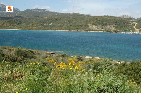
The territory has a very varied structure: large plains, gentle hills, mountains, among which the natural oasis of Mount Ferru, as well as stretches of shoreline, with both sand and rocks. The sandy coast is nearly five kilometres long: in Marina di Cardedu you will find the beaches of Foddini, Tramalitza, Museddu and Perd 'e Pera, with a sandy seabed and light, fairly fine sand mixed with little pebbles. The waters are transparent and crystal clear. Then, a one kilometre long rocky, rugged stretch begins, which is reddish in colour, typical of the Ogliastra region, and features low Mediterranean scrub. In the southernmost part of Cardedu, there is Sa Spiaggetta, with smooth, rather large pebbles.
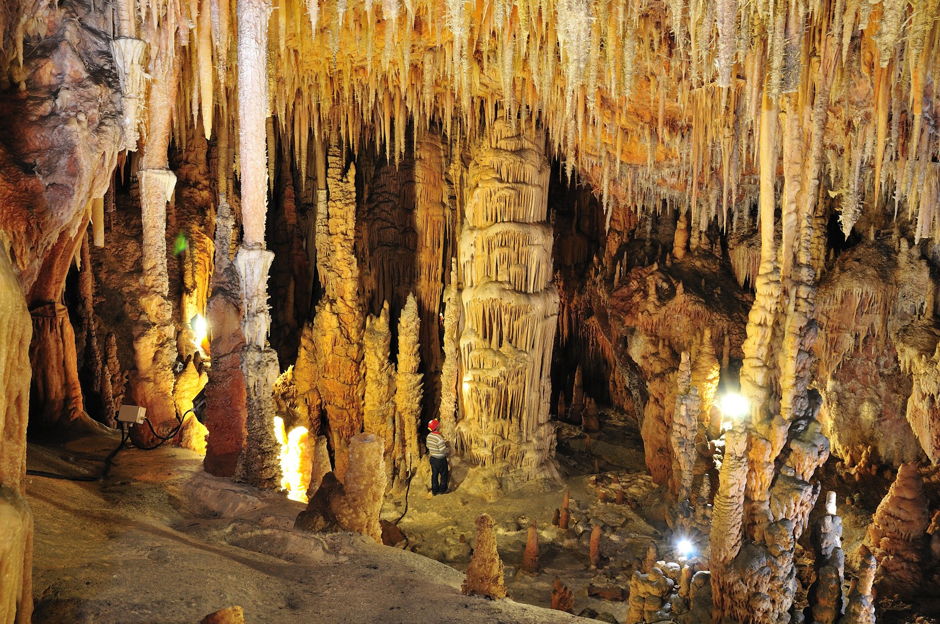
The grotto of the Miracle
From the hinterland to the coast, the Supramonte hides a subterranean world marked by the patient labour of water. As limestone dissolves, it generates treasures such as sa rutta ‘e su Meraculu, the grotto of the miracles, which faces Cala Sisine from the feet of Baccu Erettili. Visit the mystical beauty of this gem of Baunei and you will understand the origins of its name. Over millions of years, nature has moulded the rocks, creating a succession of halls enclosed by walls with limestone formations that are veritable works of art. An expressionist scenario formed by columns, stalactites, stalagmites, pisoliths, pools and glossy floors.
The grotto continues for 200 metres, at 17° C. The foyer has a narrow corridor with cauliflower stalagmites, leading to the central hall, one hundred metres long and from four to six metres high, a splendid gallery of natural sculptures.
There is also a spring, very dear to shepherds who used it in the past. The itinerary is not lacking in excitement. Among the various sculptures, one is shaped like an amphora, while a column looks like the Tower of Pisa. The “treasure hall”, pink and grey, is covered by vaults with transparent ribs that reproduce a starry sky. For a better view, climb a schist platform. The shapes are bizarre: there is an hourglass and a frog. There is even a classroom: a sturdy stalagmite is the teacher, while the shorter mounds around it look like students. The causeway was built in such a manner as to allow you to admire the profiles and have a glimpse of halls that have yet to be explored. In the ark, the slow rhythm of the water proceeds undisturbed.
Immerse yourself in the sacral Miracle atmosphere arriving from the sea, using the boat services leaving from Arbatax and Santa Maria Navarrese. Coming through land, you will get to Cala Sisine after some long, difficult and exciting trekking. From here, a track marked by pink oleanders and by the pearly grey of the pebbles in a narrow gorge, it gradually climbs all the way to the mouth of the grotto. During your stay in Ogliastra, do not miss the chance to admire the other magnificent pearls of the Gulf of Orosei: Cala Goloritzè, Cala Biriola, Cala Mariolu and Cala Luna.
San Giovanni Suergiu
Created out of the progressive joining together of several settlements, it is located on the Sulcis plain, near the lagoons of Porto Botte and Sant'Antioco, where you will observe herons and flamingos. San Giovanni Suergiu is a village with six thousand inhabitants and made up of four main districts (San Giovanni, Palmas, Is Urigus and Matzaccara), as well as a myriad of smaller urban concentrations. Its urban history began in the Byzantine age, in the 9th century, with Villa di Palmas di Sols, a village that developed thanks to the abandonment of the ancient towns of Bithia and Sulci. Still remaining from that flourishing period, you can see the ruins of the Palmas Castle (11th century) and the little church of Santa Maria (12th century), the main place of worship of that period.
In the eighteenth century, around the old Palmas di Sols, various Medaus and Furriadroxius, small villages, were formed, including that of Suergiu, which became a nucleus of the future village, known as Palmas Suergiu (1853). It underwent remarkable expansion and, in the first half of the 20th century, rapid industrial development. The Power Plant of Santa Caterina, now an abandoned site that can be visited, and coal and magnesium refineries were established. In 1952, the Municipality took on its current name: the name of the patron saint was added to the name of one of the medaus, around which it developed. In the old town centre, you will see the Late Romanesque ruins (façade and one wall) of the old church of San Giovanni Battista (14th century), a parish church until 1936. The new parish church of San Giovanni was built in 1959. On the façade you can admire a mosaic by Filippo Figari. The most heartfelt festivity in honour of the saint takes place on 24 June. It is also repeated at the end of August, when you can taste the traditional pastries (piricchittus and pistoccus de crobi).
San Giovanni Suergiu boasts a beautiful stretch of coastline and, in particular, you will be able to enjoy the soft sand and the crystal clear sea at the beaches of Porto Botte and Punta Trettu and the coast of S'Aqua Salida and Sa Terredda. The territory was already inhabited in the Pre-Nuragic period, as is confirmed by the necropolis of Is Loccis Santus, made up of 13 Domus de Janas. There are countless traces of the Nuragic age: Tombs of Giants, sacred wells, three complex Nuraghi and numerous other single-towered ones. The maximum expressions are the Nuraghi of Is Meurras and the impressive complex of Craminalana, with nearby Tombs of Giants (and anti-aircraft posts from the Second World War). The territory continued to be frequented later on: in Sa Guardiedda, on the lagoon between Sulki and Monte Sirai, there is a dock from the Phoenician-Punic period, still visible today.
Porto Ferro
A crescent of sand two kilometres long, whose thin grains with their particular dark amber colour, sometimes reddish, sometimes golden, are mixed with shells, set between the protected marine area of Capo Caccia and the head of the Argentiera. The beautiful and deep bay of Porto Ferro is the northern limit of the Riviera del Corallo, a coastal enclave of Sassari, twenty kilometres from Alghero. Inside it "protects" one of the widest beaches of the impervious coast of Nurra, selected as one of the most beautiful in Sardinia by the Touring Club Italy, and the most 'sustainable' by the FEE (Foundation for Environmental Education), awarded the Blue Flag for 2016-18.
The inlet, where some rocks appear here and there, is bathed by clear waters with emerald green and iridescent blue hues, and is framed at each end by headlands of reddish trachyte punctuated by Mediterranean scrub, backed by a beautiful pine forest. The trees, along with sand dunes covered with sea lilies, separate the beach from the beautiful scenery of Lake Baratz, the only natural lake on the island. Three towers, built in the seventeenth century by Spanish against the Saracen threat, watch over the town from above: Bantine Sale (or Torre Mozza) to the south, Negra and Bianca (or Airadu) to the north. Nearby, the medieval village of Barace stood, whose inhabitants traded salt.
The beach, never crowded, has a range of parking and dining options. The seabed slopes gently from the shore, and frequent wind and high waves make it a destination for lovers of surfing and windsurfing. The northern part, near the White Tower, is frequented by nudists, inserted by Skyscanner, an English language holiday and travel web portal, in fifth place among the most beautiful nudist beaches in Europe.
North of Porto Ferro, also in the territory of Sassari, you will find the enchanting Porto Palmas, also a Blue Flag beach, and Cala dell'Argentiera, surrounded by the industrial archeology scenario of a mine that was very active for centuries up until 1962, and exploited for its rich reserves of lead, silver and zinc. The ghost mining village creates an evocative atmosphere, with its cove of sand mixed with gravel, where the sparkles of the sea contrast with the brown of the surrounding rocks. To the south of Porto Ferro, inside the marine area of Capo Caccia, lies the tranquillity of Mugoni, an expanse of two kilometres of light and soft sand that plunges into the emerald green sea, completely sheltered inside the bay of Porto Conte. Behind it, a pine and eucalyptus forest create a tropical paradise setting. This is one of the endless attractions of the coast of Alghero, which stretches for about 90 kilometres. Some of the unmissable beaches include: Le Bombarde, the most famous; the beach and the delightful coves of the Lazzaretto, the three kilometres of soft sand of the 'town' Lido and the sandy dunes covered with centuries-old junipers of Maria Pia. And then there is Punta Negra, Cala Dragunara, from where boat trips leave to visit the Grotta di Nettuno, the beaches of Capo Caccia and the coves along the road to Bosa: Cala Bona and Burantì.
Arzachena
Breathtaking landscapes, beaches of incomparable beauty, hills covered with vineyards and archaeological treasures. A vast and unique territory characterizes Arzachena, a small town in the Gallura region, 25 km from Olbia, with a population of 14 thousand residents in the wintertime. There are the same number of beds at the hotels in a locality in constant demographic and economic growth and famous for the Costa Smeralda, a symbol of elite tourism that emerged in the 1960s. Things that contribute to its marine prosperity are granite mining, a distinctive feature of the architecture in the old town centre, and famous wineries producing Gallura’s Vermentino wine. Until the 17th century, the little residential area of Arzachena was just a small group of little houses located around the church of Santa Maria. Today, it is a triumph of colours: little squares and facades of pink granite and white stone, flower-filled views and green spaces dotted with boutiques, delights and artisan products. Around the little town, there are the typical stazzi, rural settlements converted into B&Bs and agritourism facilities, as well as numerous districts in a ‘young’ Municipality established in 1922. The largest ones are Abbiadori, Baja Sardinia, Cannigione, once a fishing village and now a tourist village, and Poltu Quatu, a modern marina in a ‘fiord-like’ cove. Then there is Porto Cervo, an architectural 'gem' that blends with the landscape and the most exclusive holiday location in Sardinia, brimming with yachts and celebrities in the summer, as well as aperitifs and elegant evenings, scintillating nightlife, luxury hotels and villas, glamorous restaurants and clubs, sailing and golfing events.
All around, there is wild scenery, like Capo Ferro, and countless Costa Smeralda beaches. Cala Granu stands out, as does the ‘crescent-shaped’ expanse of soft white sand of Grande Pevero. Behind it, there are the well-kept greens of the Pevero Golf Club and opposite, there are the islands of Li Nibani. A destination very popular with celebrities is the Piccolo Pevero, the long half of its ‘big brother’. Then there are the delightful coves of the Romazzino bay. Poltu di li Cogghj was the Aga Khan’s favourite beach: it is known as the Prince’s Beach and is a stretch of fine sand divided by pink rocks. On the opposite side of the Costa Smeralda promontory you will be entranced by La Celvia, with fragments of shells and quartz powder, overlooking Cala di Volpe, a little harbour where scenes from ‘Agent 007- the spy who loved me’ were filmed. Further South, behold the spectacle of the most beautiful Costa Smeralda beach, Cala Capriccioli. The landscape is enriched by the little islands in the Arcipelago di La Maddalena National Park: Soffi, Camere and Mortorio. In the distance, you will see the shoreline of Liscia Ruja: coves lit by the white brushstrokes of sails. The largest beach is the scene, during the 15 August Ferragosto holiday, of a great celebration. Closing the coast, is the, evocative and secluded La Suareddha. Other masterpieces scattered throughout the 90 km of the Arzachena coast, include the ‘silky’ stretches of Tanca Manna and the splendid Ea Bianca (or Cove of the Junipers). Near La Sciumara there is Padula Saloni, a pond populated by herons, black-winged stilts and western marsh harriers and a bird watching destination.
Arzachena is not just sea and high society, but it has a fascinating past that made a permanent mark. In the old town centre there is the monti incappiddhatu (mountain with a hat), a rock known as the Mushroom, shaped over time in an original way and used since the Recent Neolithic Age. A walk in the countryside you will allow you to discover a vast archaeological park. The oldest and most famous site is the Li Muri necropolis (late 4th millennium BC), known as ‘grave circles’. Among the evidence of the Bronze Age, the nuraghe Albucciu, a ‘corridor-type’ building, hidden in a wild olive thicket. The remains of the village are around the nuraghe and 80 metres away there is the tomba Moru, the result of the transformation of an allée couverte into a Tomb of Giants. Nearby, you will find the little temple of Malchittu, the ‘theatre’ of ritual ceremonies. Not to be missed is La Prisgiona in the valley of Capichera, consisting of trilobed nuraghe and a village of approximately one hundred huts. To conclude the archaeological tour, there are two Tombs of Giants built in multiple phases between the Early and the Intermediate Bronze Age: the tomb of Coddu vecchiu with a four-metre high stele, and the famous tomb of Li Lolghi, made entirely from granite, with a long burial chamber and a long exedra, respectively 27 and 26 metres in length.

Masullas
Alleyways and homes built in exposed sandstone blocks from the nearby quarries huddle together on the slopes of a hillside between the valleys of Alta Marmilla. Masullas is a small town of around 1000 inhabitants, part of the Borghi Autentici d'Italia circuit, and occupies a suggestive part of the Mount Acri park, which includes the Tarxi forest, the rocky cliff of su Columbariu and the Obsidian park of Conca 'e Cannas, Sardinia's largest source of prehistoric "black gold" that has been attracting peoples to travel from all over the Mediterranean ever since the 6th millennium BC. The deposit is hidden in the bowels of the extinct volcano, covered by elms, holm oaks and Mediterranean brush. Mount Arci is ideal for excursions: you can admire sa Perda Sperrada, a stone block split exactly in half, and the prenuraghic menhirs of sa Pedra isposa. You will also find the remains of twelve nuraghes, including the su Para nuraghe.
The Rio Mannu has always supported farming in Masullas. Founded in Roman times - as confirmed by the necropolises of Mitza Salida and sa Roia de sa lua - the town acted as a stopping point on the way towards the centre of the island, where travellers would stay in the masones (refuges). Other hypotheses suggest the name could derive from masiullas (small homes) or mansio (farm). What is certain is that the town was created by merging two villages that grew up around the late-Romanesque medieval churches of Santa Lucia (celebrated in mid-December) and the older San Leonardo (celebrated in mid-November), built in the 13th century on an existing site. When the parish church of Madonna delle Grazie was built, the two villages merged. The church was restored in the late 17th century with a wooden roof and new facade. During the restorations, a paleo-Christian font was found (6th to 7th century AD). The church also hosts a wooden retablo (1676). The festival of sa Glories is held to celebrate the patron saint in early July, with a procession of traditional costumes, horse riders, traccas and launeddas music.
The monks also left the 17th century Convent of San Francesco, linked to a church that holds a collection of wooden statues and sculptures (15th to 19th century) by Capuchins and Jesuits. Today, the ex-convent hosts the GeoMuseo dedicated to Stefano Incani, with an incredible display of minerals and 1800 fossils, narrating the geological evolution of the Marmilla area. Don't miss the I Cavalieri delle colline museum, telling the history of feudal aristocracy through works of art, weapons, costumes, documents and ancient books. To celebrate the fruit that symbolises the town, a pomegranate festival is held in early November, with tastings of jam, liquors and local delicacies: pasta (crogoristas and tallutzas), roast or stewed meat (with artichoke and potatoes), and almond pastries (amarettus and gueffus). In May, you can try a traditional recipe at the free-range chicken festival.
Marina di Cugnana
Marina di Cugnana is found in the area of Marina di Cugnana, in the commune of Olbia. The beach is characterised by the presence of rocks and pebbles. The beach is small but the crystalline water and the suggestive Mediterranean vegetation that surround it, make this an absolutely beautiful angle of paradise.

Archaeological Museum of Villasimius
The history of Villasimius and its territory are inextricably linked to the sea. The stories of clashes and encounters between the different peoples who crossed paths in its waters, often exchanging goods, customs and knowledge, are told in the archaeological museum, located in the rooms of a 19th-century rural ‘courtyard’ house. A staircase with terracotta tiles, leading to the upper floor, and a wall made of ladiri (raw earth bricks) are what remains of the ancient manor house. The exhibition contains artefacts that date back to a period of time ranging from the Nuragic age to the Spanish domination in the Middle Ages. Many were recovered from the seabed, from wreckages and during underwater excavations. The museum is spread over two floors and four rooms, along an itinerary based on both a chronological and a thematic criterion.
The first room is called ‘of the sea’. Trade, routes and shipwrecks are the common thread of the exhibition, in which, in particular, you will see Punic amphorae from the 5th century BC. They probably came from the Balearic Islands and were found in front of Isola dei Cavoli. The second room focuses on the artefacts from the sanctuary of is Cuccureddus, perhaps dedicated to the goddess Astarte. You can admire the reconstruction of its external appearance, as well as numerous objects of daily use dedicated to care of the body and food preparation. The votive offerings and bronze coins provide evidence of the Roman era. You can continue the visit in the territory room: the room contains the cargo from the ‘relitto del canale’ (shipwreck of the canal), a Roman ship from the 1st century AD that transported building materials and sank in the canal of the Isola dei Cavoli. In this room, you can also admire materials from the Santa Maria area, where a thermal baths building was installed, later used as a necropolis in the early Middle Ages, and from the Roman necropolises of Cruccuris and Accu is Traias. There is a marble statue that comes from the thermal area, depicting a woman, associated with the Virgin Mary in centuries past and used as an object of worship in the nearby church.
The last room is entirely dedicated to the Spanish wreckage of the Isola dei Cavoli, of a ship that probably sank due to a storm in the 15th century while sailing towards Sicily. You will be surprised by the weapons, particularly the cannons, and the azulejos, unusual cladding tiles with a blue and gold enamel coating. In the Villasimius area, there is other evidence of the Aragonese Crown: the most obvious is the Fortezza Vecchia, a defence tower perhaps dating back to the 14th century and built on a rocky promontory south of the village. Today, a permanent exhibition on piracy is held there and it ‘guards’ the eastern extremity of the Golfo degli Angeli (Gulf of Angels) and the Marine Protected Area of Capo Carbonara. On the subject of the sea, around the cape you will find the picture-postcard coastlines of Simius, Porto Giunco, Cala Caterina, Santo Stefano and the Spiaggia del Riso, next to the tourist port.
Civic Archaeological and Palaeobotanic Museum
The museum of Perfugas showcases findings from several archaeological sites in the area. It includes a palaeobotanic and an archaeological section. Fossils of plants similar to palms, cypresses and poplars are on show: they come from the petrified forest of Anglona, which was formed between 30 and 15 million years ago from the gradual silicification of the plants.
The Palaeolithic section houses the oldest human artefacts so far found in Sardinia: flint stone tools from the Early Clactonian from Rio Altana and the scrapers and denticulate implements from Sa Pedrosa-Pantallinu from the Late Clactonian.
The Neolithic period is represented by the statuette of the 'Mother Goddess with child', which is the first known 'kourotrophos' in the Western area (4th millennium B.C.). The Nuraghic civilisation is witnessed by pottery, stone tools and bronze utensils, including an interesting intact dagger with y-shaped hilt. The historical period is represented by imported artefacts dating from the 7th-6th centuries B.C., the sign of thriving communities in late Nuraghic settlements in the territory, by Attic and Punic vases from the 5th-4th centuries B.C. and by Hellenistic and Roman ceramics. The Early medieval period is witnessed by 5th-century clay pots, a 6th-century bronze ring, glass paste beads and a 7th-8th century spear tip. Objects from the 9th-13th centuries AD are also on show.
A visit to the museum offers a complete overview of the ancient history of the Anglona district, which was settled continuously from the Late Palaeolithic.
Address: via Nazario Sauro, 07034 Perfugas. Phone: 079 564241 Managing Agency: Municipality of Perfugas

Modolo
It is situated in a splendid valley that gives it its name and surrounded by gentle, fertile hills. Modolo is a tiny village of fewer than 200 inhabitants in the Planargia area, four kilometres from Bosa and 50 from Oristano. In its territory, used for agricultural activities, thriving cherry trees, centuries-old olive groves and fragrant vineyards grow, giving the landscape a picturesque appearance. The most renowned production is that of wine-growing and viticulture, particularly Malaysia grapes.
The little village may have emerged around the 3rd century BC, during the Punic era. Still remaining from Roman domination is a villa in the outskirts of the village and the name Modulo valise, a mansion crossed by the western road from Sulki (Sant'Antioco) to Neapolis, Othoca (Santa Giusta) and Cornus (ancient Cuglieri) and continued on to Bosa. The name was turned into Modolo in the Middle Ages. The area where it is located was frequented in the Neolithic age, as is demonstrated by several domus de Janas, and it was inhabited in the Bronze Age, and the many Nuragic monuments bear witness to this. In the Modolo valley (in the territory of Suni) there is the Seneghe nuraghe with a six-metre tall tower, built with huge basalt horizontally-placed blocks, a corridor from which three recesses and two architraved entrances branch off.
The main monument of the village is the parish church of Sant'Andrea Apostolo, dating back to the Early Middle Ages (7th century AD) and founded by Byzantine monks who evangelised the territory. Inside the church, there are wooden 17th-century statues and a crucifix. Other churches are dedicated to the Madonna del Grappolo, to St Isidoro and to Santa Croce. The most heart-felt celebrations are for those for the patron saint, twice a year: mid-May and the end of November. Other traditional festivities are the Fuochi di Sant'Antonio Abate in mid-January, with tastings of wine and typical local products.