

The Sea Oxen Grottoes
Here once reigned “sea oxen”, as the locals used to call monk seals due to their tapered shape and tame behaviour like that of an ox. These magnificent mammals, now (maybe) extinct, gave their name to a marvel of nature: the Sea Oxen Grottoes (Grotte del Bue marino), since the 50’s one of the main attractions of the Gulf of Orosei, in particular in Cala Gonone, in the Dorgali territory. Today they are a favourite destination among nature lovers, and the ideal union between sea and mountain: they are part of the karstic system Codula di Luna, Italy’s largest, seventy kilometres of tunnels in the bowels of Gennargentu.
Its majestic entrance, formed by two arches over the sea, is located three kilometres away from splendid Cala Luna. The marine caves are 15 kilometres long in total, and divided in two main branches. The northern branch, fossilised due to the interrupted karstic activity, is not accessible to the public. However, you can visit the southern branch thanks to illuminated causeways, for about 900 metres. Speleologists are allowed to explore an additional four kilometres (of the overall 5 of this branch). Seawater penetrates the wide hall, and countless little ponds of sweet water from subterraneous rivers abound, separated from sandy beaches filled with concrete formations. The “tourist” itinerary among stalactites and stalagmites offers an extraordinary colour spectacle, thanks to the light beams that penetrate it. You cannot help but gasp in awe at the long shadows projected on the waters of a subterranean saltwater lake, with more than one square kilometre of surface.
The cave is also famous for esoteric rock paintings, dated back to the Neolithic, illustrating a circle of people around what is supposedly a representation of the sun. The walk finishes in the seal beach – these sea mammals once came here to mate and have their cubs. The visit is led by expert guides and lasts about one hour. To reach the grottoes, use boat services leaving from Arbatax, Cala Gonone, La Caletta, Orosei and Santa Maria Navarrese. Another unique attraction of the place is the yearly celebration, inside the grottoes, of a spectacular concert as part of the Cala Gonone Jazz festival. When visiting the Gulf of Orosei, do not miss the chance to visit the magical world of Dorgali: history, archaeology, manufacturing arts and natural heritage in 225 square metres.
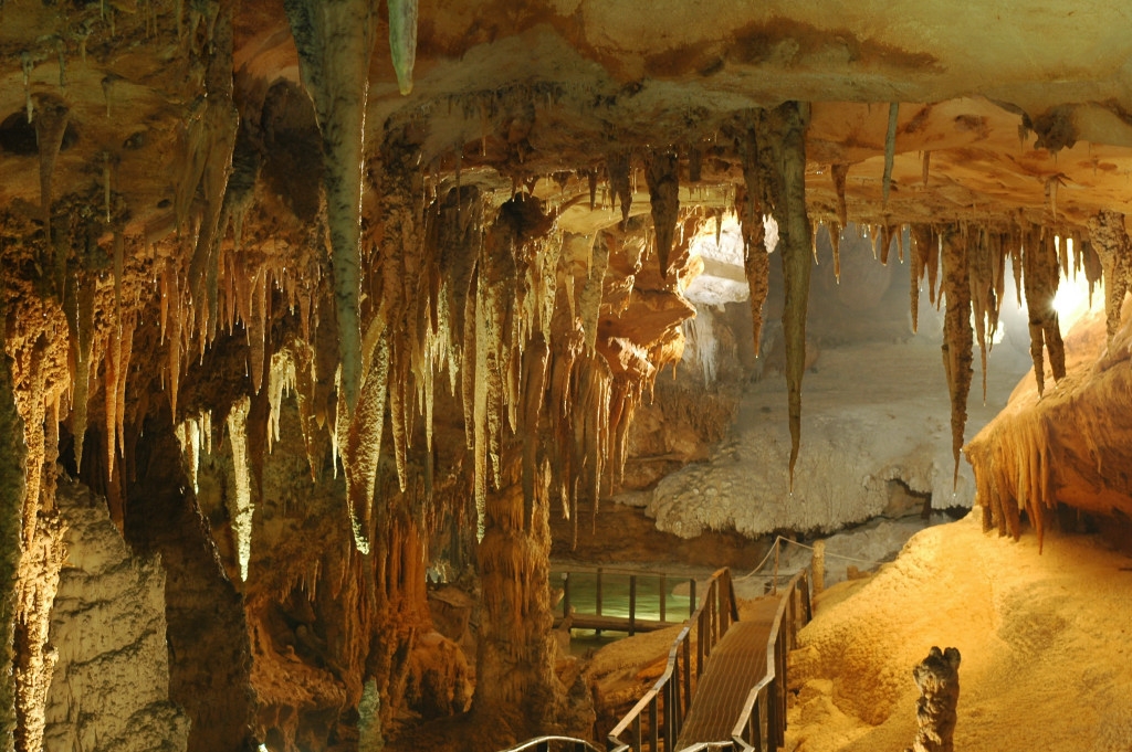
Grotta del Fico
At first, you will be enshrouded by the darkness, then, as you gradually move forward, you will see before your eyes a place in which time seems to have stopped 800 thousand years ago, when the first rooms of the Grotta del Fico cave were formed, one of the pearls of Ogliastra, in the territory of Baunei. Stalactites, stalagmites and columns of different sizes and colours enclose every wall of the cave, creating curious shapes. A system of tunnels and easy footbridges will allow you to walk along the fossil bed of an ancient river. The route penetrates deep into the earth, dug out by the water, within the sheer cliffs overlooking the sea of the Gulf of Orosei. Close by, there are charming little coves that can be reached by sea or via trekking trails: Cala Luna, Cala Biriola, Cala Mariolu and Cala Goloritzè.
During the first exploration (1957), the cave revealed its wild appearance and various naturalistic treasures. The writer Marcello Serra renamed it 'Cave of the Castle' due to its majestic front overlooking the sea. Open to the public since 2003 and renamed 'del Fico', it has an entrance situated at a height of seven metres up on the cliff, which you can reach from the boat by climbing up a walkway. From the entrance, you can see the nearby stretch of gulf, an amazing seascape. You will be able to visit it with expert guides who will accompany you through the main tunnel that leads to a large pool communicating with the sea. In the depths of the reservoir, the first speleologists to explore it witnessed an unforgettable sight: in that body of water, they noticed the darting bodies of the Mediterranean monk seals. Here, the first studies were conducted on the animals that perhaps left the eastern coast, but it is not uncommon to see traces of their passage. The visit to the various spaces and tunnels, embellished by limestone formations, known to date, lasts 45 minutes but for speleology experts and enthusiasts, it is also possible to visit part of the cave that is not equipped with walkways.
From the hinterland to the coast, the entire Supramonte di Baunei area conceals an underground world marked by the patient work of the water. Not far from the Grotta del Fico cave, overlooking the not-to-be-missed dreamy little cove of Cala Sisine, you will find another natural wonder, created by the dissolving limestone: it is the Grotta del Miracolo (Cave of Miracles) and you will understand the reason behind its name when you visit it.
Berchidda
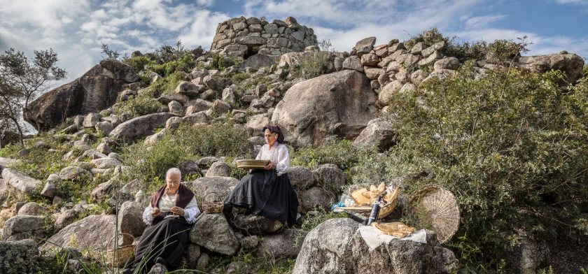
It lies on the southern slopes of Mount Limbara, the 'mountainous heart' of Gallura, that surrounds it with granite rocks shaped by the weather, not far from Lake Coghinas. Berchidda is a village with three thousand inhabitants, with Neoclassical and Art Nouveau houses and buildings positioned in a 'crescent' shape in steep streets. In the centre, you will find the parish church of San Sebastiano, with its wooden Baroque altar, and the seventeenth-century church of the Rosary. From the main square, you can enjoy a breathtaking view of the valley and Mount Acuto, an elevation that gives a name to the territory. On the occasion of Time in Jazz, which lasts for a week, around the 15 August Ferragosto holiday, the village puts on its best clothes, the squares become a theatre, the streets come to life with the colours and sounds of the nighttime concerts, starring the famous trumpet player, Paolo Fresu and musicians from all over the world.
By day, the rural churches of Santa Caterina and Sant'Andrea (seventeenth century), as well as the garden of the butterflies on Mount Limbara are settings in which the musicians improvise, inspired by the silence and beauty of nature. Berchidda's fame grew throughout the world at the same speed as Fresu and the international festival, which has been the key event of the island's jazz circuit.
Near the village, at an altitude of 500 metres, you will find the castle of Montacuto, built in the 11th century, a political and military centre and witness to the local medieval events taking place: it belonged to the Judges of Torres and those of Arborea, was the object of a dispute between Pisa and Genoa and, in the end, fell under Catalan rule. The remains of walls, a tower and a cistern still remain. The territory is rich in evidence from prehistoric times: tafoni and inhabited caves, Domus de Janas necropolises, dolmens, megalithic structures (Pedriscalas and S'Iscala Serrada), tombs of Giants and nuraghi. There are numerous Roman traces: Republican coins, the remains of the Olbia-Turris Libisonis and a bridge along the Silvani river. The road and fortifications of Su Casteddu indicate that this was once a transit area disputed between the "Romanized" and rebellious populations (the Balares).
The village is surrounded by the colours and fragrances of centuries-old oaks and holm oaks, brooks and little waterfalls, like that of Su Pisciale. The territory is populated by deer, fallow deer and mouflons, while northern goshawks and Eurasian sparrow hawks fly overhead. Then there are the vineyards: Vermentino di Gallura is produced here and is the only Sardinian wine with a DOCG (controlled and guaranteed designation of origin) label. The wine museum is located at the foot of the hill of Sant'Alvara and it retraces the history of grape-growing in Sardinia. Associated with it, is the regional wine shop, where wine tasting takes place and wine is sold. The wines from the local wine cellars accompany a unique culinary experience: things you should absolutely taste are sospiri, almond cakes, and suppa cuatta, 'flat breads' in sheepmeat broth, fresh and mature pecorino cheese. Other delicacies are maccarones furriados and sas laldadinas, filled pasta parcels. The economy is also based on cork processing and on breeding, to which the sheep festival is dedicated, taking place in May. Eagerly anticipated events are the rural festivals of San Marco (25 April), San Michele (mid-May) and Santa Caterina (beginning of June), where you can discover authentic flavours (cured meats, cheeses, cakes and pastries) and admire splendid traditional clothes.

Supramonte di Dorgali
The Supramonte is a mountainous complex characterised by carbonatic highlands and dolines. With an area of around 35,000 hectares, it also takes in the long stretch of coastline of the Golfo di Orosei and it falls within in the territorial areas of the municipalities of Oliena, Orgosolo, Urzulei, Dorgali and Baunei. Enormous rocky bastions characterise the landscape, alternating with deep canyons and rocky peaks that tower into the sky. The Supramonte, for ease, is divided according to the territories of the municipal areas in which it falls. The Supramonte of Dorgali falls among the valleys of the Flumineddu and the Cedrino and also contains the basin of the Lanaittu. On the border with the valley of Lanaittu a steep calcareous mountain rises, that was home, inside an enormous doline, to the spectacular Nuragic village of Tiscali. The gorge of "Su Gorroppu" is remarkable: deep and narrow, it separates the Barbagia from the Ogliastra. It is a splitting between the calcareous mountains of Dorgali and those of Oliena and it makes a favourite shelter for rare species of birds of prey. Its extends as far as the coast up to Cala Luna with characteristic examples of calcareous rock, smoothed walls and large fissures. Numerous caves open out onto the coast, among which that of Bue Marino famed for the presence of the monk seal in times past.
Su Nuraxi 'e Pauli
It has always been surrounded by an air of legend, while its position, structure and closeness to similar fortresses suggest that it was a ‘lookout nuraghe’, part of a territorial control system. Su Nuraxi ‘e Pauli gets its name from the area in the Seulo territory in which it is located, just over two kilometres from the town. It is a single-tower nuraghe, built by the laying of uneven rows of schist blocks. It has a diameter of just over ten metres, while the tower has a residual height of around seven metres. You will be surprised by the considerable wall thickness of over two metres. From the entrance, you enter a passageway with an ogival roof. On the left, a staircase opens up and its steps lead to the top of the tower; while you will notice a niche on the right. The passageway ends in the main chamber, with a circular layout, where you will notice two other niches.
The nuraghe stands on the top of a rocky elevation, from which you can admire a captivating view over the Rio Medau, dotted with oak woods, with Mount Perdedu in the background. The other name of the nuraghe is Mannu, to distinguish it from another tower that stands two hundred metres to the south-east: this is su Nuraxeddu, ‘the small nuraghe’. The tower has partially collapsed but a few rows have been preserved and are the same in every respect to those used for su Nuraxi ‘e Pauli. Su Nuraxeddu also shares the thickness of its walls and the presence of niches in the main chamber with its ‘larger neighbour’. According to a popular legend in Seulo, the two towers are connected by an underground tunnel dug into the schist rock and impenetrable to attackers. The position of the second nuraghe is, in any case, strategic: in addition to the visual contact with the main tower, from the top of the hill on which it stands - around 700 metres above sea level - it dominates the valley of the Rio Medau more closely, beyond which it maintains visual contact with the Nuragic settlement of the nearby Taccu ‘e Ticci plateau. Here, you can see traces of a village with around thirty buildings, a Giants’ Tomb and the remains of a third nuraghe. Unlike the other two, the Taccu ‘e Ticci was probably a complex type of nuraghe, as traces of at least three secondary towers seem to be have been identified around the keep. Not far away, to the south-east, you will see the Giants’ Tomb: a rectangular body has been detected with the burial chamber inside, while the exedra is of the row type.
The Seulo territory is not only famous for its archaeological heritage, but also for its scenic treasures, linked above all to water: on the border of the Sadali territory you can admire the spectacular waterfall of su Stampu de su Turrunu: the water has carved a ponor into the rock face that has, in turn, generated a cave, from which the waterfall plunges into a crystal clear pond. Another unmissable waterfall is located on the border of Gadoni, namely sa Stiddiosa: here, the water dribbles like light rain, falling into a natural emerald green pool.
Onifai
Set in a natural amphitheatre that opens to the south, towards the plain of Orosei, Onifai lies between the Su Gollei plateau and the bank of the river Cedrino. Onifai is a town with just over 700 inhabitants. In the historic sub region of Baronia, it is famous for its food and wine, such as exquisite cheeses, prized honey and delicious cannonau and vernaccia wines. The production of olive oil from the ancient olive groves, traditional breads, pastas and desserts is also characteristic. One opportunity to savour these delicacies is during the summer market-show of Gusti e Sapori Onifaesi. The Villa di Onifai, built under the Aragonese (1409), belonged to the Guiso family of feudal lords of the barony of Orosei for four centuries. The first settlement was built near the Chiesetta di san Giorgio, dating back to the end of the 14th century and once a parish church. In mid-April, the much-loved celebration of the patron saint is celebrated. The current parish church of San Sebastiano, which was reopened in 1765 after reconstruction, presents Romanesque features with strength and sobriety. From the Chiesa della Vergine di Loreto, a splendid panorama over the Cedrino valley can be taken in. Mid-January in the churchyard of the Chiesa di Sant’Antonio da Padova, the Fuochi di Sant’Antonio Abate are lit, accompanied by an offering of typical sweets, beans with lard, and wine. From 30th May to 13th June, there is the ‘Tredicina’ for the Saint from Padua, which sees his simulacrum accompanied in a procession by groups wearing traditional clothes, including the sumptuous garments of Onifai. Rising up in the Parco degli Ontani is the Santu Juanne Istranzu, built in granite in 1968, where Saint John the Baptist is celebrated on June 24th. Also of great significant for the locals are the rituals of the Settimana Santa (Holy Week), led by the confraternities of Santa Croce and Carmelo, and the ancient custom of Sas Animas for Ognissanti (All Saints).
Majestic centuries-old junipers dot the countryside, whilst alder trees, poplars and willows form the habitat of purple herons, western marsh harriers, Audouin’s gulls, common moorhens, common kingfishers and western swamphens, all in the surrounds of Cedrino. Looming over the village is Monte Tuttavista, covered with holm oaks, cork oaks, conifers and Mediterranean scrub. The rocks of the massif are 450 million years old and can be explored in the Conca Niedda and Fraigada peaks. Heading towards the valley, there is the Sa Badde Conca Manna, which takes its name from a hole in the limestone. On the eastern border of the Onifa territory stands the peaks of Artu De, Istiotha, Nidu Abile, where one can view spectacular granite forms shaped by time, including the Sos Sombreros, the form of which resembles a sombrero. Fascinating visit is Monte Oddie, where basins have been used as Nuragic houses. The territory was inhabited as early as the Neolithic period, as evidenced by Dolmens of Istrullio and the Domus de Janas of Doddoi, Enas, Isthiolài, Oddoene and Ominzana, composed of atrium and interconnecting funerary chambers. From the Bronze Age, there are the Tombs of Giants of Cutinas, the fortified hills of Ortzidda and Locherie, the Protonuraghi Perchètha and Rampinu and Nuragic structures leaning against the natural rock, such as Latas and Omine Intreu, and tholos such as s’Iscampiatòrju. A double wall encloses the fortress of Osana, consisting of Polylobed Nuraghe and a sacred spring. In the surrounds are the remains of huts.
Archaeological Park of Scerì
It is one of the most interesting examples of the talent of Nuragic Age architects to exploit natural elements for the construction of their buildings. The Scerì complex sits in a strategic position perched on the top of a granite tower, partially surrounded by a river, in the Ilbono area. Once inside this archaeological park, you’ll find a nuraghe, a village and two domus de Janas (in Sardinian, a House of the Fairies).
The largest building is a nuraghe, a complex version with an added wing, all built out of medium-sized squared granite blocks. The remains of the main tower, of which just under five metres still stands, is circular. The entrance features a well-hewn architrave and leads to a rectangular antechamber that once led to an inner room. Another architrave entrance, this one trapezoidal, is found at the northern end and leads to a curved corridor, at the end of which is the adjacent building. You will note two niches along the corridor, one on either side, and on the right, you’ll see another opening that leads to a second corridor which is, however, blocked with rubble. Under the tower you’ll find several natural cavities integrated with stretches of wall. At a lower level there was a counter wall with an entrance on the eastern side, it too integrated with rocky outcrops in several places.
Adjacent to the nuraghe was a large village of huts, used both for living and working, where materials were found that allowed the site’s Nuragic phase to be dated to between the Middle and Recent Bronze Ages (15th to 12th centuries BCE). West of the complex you’ll come across two domus de Janas, both single-celled, carved into two large boulders during the Middle Neolithic (4th millennium BCE). The first one has an entrance preceded by a small pavilion. It features a small, oval room. The second was damaged when the front of the boulder near the entrance collapsed, but you can still admire the precision of the sanding on the walls and floor.
The area of Ilbono is home to numerous historical landmarks: at least a dozen nuraghe, most with a single tower, and a variety of Giants’ tombs. Less than nine kilometres separate the town from another famous Nuragic complex in the Lanusei area. Nestled in a fairy-tale landscape on a meadow at an altitude of 1,000 metres, lies the Seleni Woods Archaeological Park. Surrounded by oak, chestnut and poplar trees you will visit a nuraghe, a village of some 200 huts, two Giants’ tombs and two sacred springs.

Ussassai
The town sits perched at over 700 metres on the north-eastern slopes of Monte Arcuerì, overlooking the San Gerolamo river valley below, protected by limestone-dolomite bastions and deep gorges covered in woods. With less than 600 inhabitants, Ussassai is the smallest of the towns of the Barbagia di Seulo, as well as being its easternmost, not far from Ogliastra along state motorway 198, the road that connects Seui and Lanusei. The views from town are breathtaking: around the shimmering walls outcrops of rock have been sculpted by the passage of time, erosion, and some now resemble known personages, like the one they call Dante because it looks like the poet’s profile. The limestone stacks effectively isolated the area for centuries and thus also preserved its pristine beauty. There is a myriad of streams, oak and cork trees and Mediterranean shrubbery in which to go hiking and biking, especially in the Takiggeddu, su Piss’e Irtzioni and Niala woods.
A part of Montarbu (most of which is under the jurisdiction of Seui) falls under Ussassai, an area of pristine nature, home to one of Sardinia’s loveliest forests, a fauna oasis since 1980, where deer and mountain goats roam, the hunting grounds of royal eagles and peregrine falcons. You can also go visit the lovely landscape of bare peaks and verdant nature in something of an alternative way: on board a Trenino Verde (Green Train), whose Mandas-Arbatax line stops at the old Ussassai station that was inaugurated in 1893, today used exclusively for tourist services.
The town’s origins date back to time immemorial and it is steeped in rural tradition. The lower part stands out for the old stone houses while the upper part of town boats modern dwellings. The main church, which is home to a precious ostensory dating to 1625, is dedicated to San Giovanni Battista, celebrated in late August. A week earlier – on 10 August – they celebrate San Lorenzo. Ussassai is famous for its red apples, the stars of festivities at the end of October when locals make such delicacies as culurgiones cun sa mècuda e is coccois prenas. Another important date is the Coja antiga in the second half of August, with a heartfelt traditional re-enactment of rural wedding. At santu Gironi, in the countryside not far from the town, is the sanctuary of San Salvatore. The Romanesque-Byzantine building dates to the XII century and houses stone trunks placed in a semicircle, the famous cumbessias, or accommodations, for the faithful who flock here to celebrate San Salvatore and San Gerolamo (12 and 30 September respectively). The church may have been the parish church of the old town of Trobigitei, which was abandoned and disappeared under Aragonese rule.

Pedra Longa
At first glance, it looks like a huge rock, but in reality it is a 'piece of mountain' that has fallen from the surrounding cliff, a link between the Gennargentu massif and the Gulf of Orosei. Pedra Longa is a calcareous-dolomitic block, an integral part (detached) of the vast Baunei plateau. Its 'spire' shape rises from the sea to a height of 128 metres: it is one of the highest rocky outcrops on the island, directly overlooking the sea, and was declared a natural monument in 1993. The original name is Aguglia or Agugliastra, from which Ogliastra is said to derive and which gives the idea of the shape enlarged at the bottom and slender at the top (‘aguglia’ means needlefish in Italian). This is what it was called in the past by mariners and was mentioned in pilot books because it was a reference point visible from many miles away.
The most fascinating way to discover it is along walking routes that descend from the cliffs to the coast. This is the starting point for the 'Selvaggio blu' (Wild blue), a week-long itinerary that leads from Santa Maria Navarrese, a coastal village in Baunei, to Cala Gonone, the most difficult trek in Italy, with 'alpine' stretches and stupendous scenery between rocks and sea. The first mini-stage arrives at Pedra Longa, an atmospheric approach and preparation for the much more demanding tests of the following days. During the four and a half kilometres of the route, Ogliastra is revealed in all its beauty: snap a photo on the terrace overlooking the sea, just before the destination. An easy path leads northwards from the Pedra, parallel to the coast, to the resort of Loppodine. Another more difficult route, with a considerable climb, leads behind the 'pietra lunga' ('long stone'), towards the north, where the punta Giradili peak rises majestically, the 'roof' of the gulf, standing at 700 metres plus and among the highest crags in the Mediterranean. The first climbing route on the Pedra, called 'luce senza memoria’ (‘light without memory'), dates back to 1981, a 250-metre-long crossing, two to ten metres above the water. The route, with difficulties up to V+, is free, with no pitons or ropes: experienced climbers can take it as they please. A second route on the south face, known as the ‘cromosomi corsari’ (‘pirate chromosomes’), is breathtakingly beautiful, but requires a great deal of caution and the accompaniment of guides.
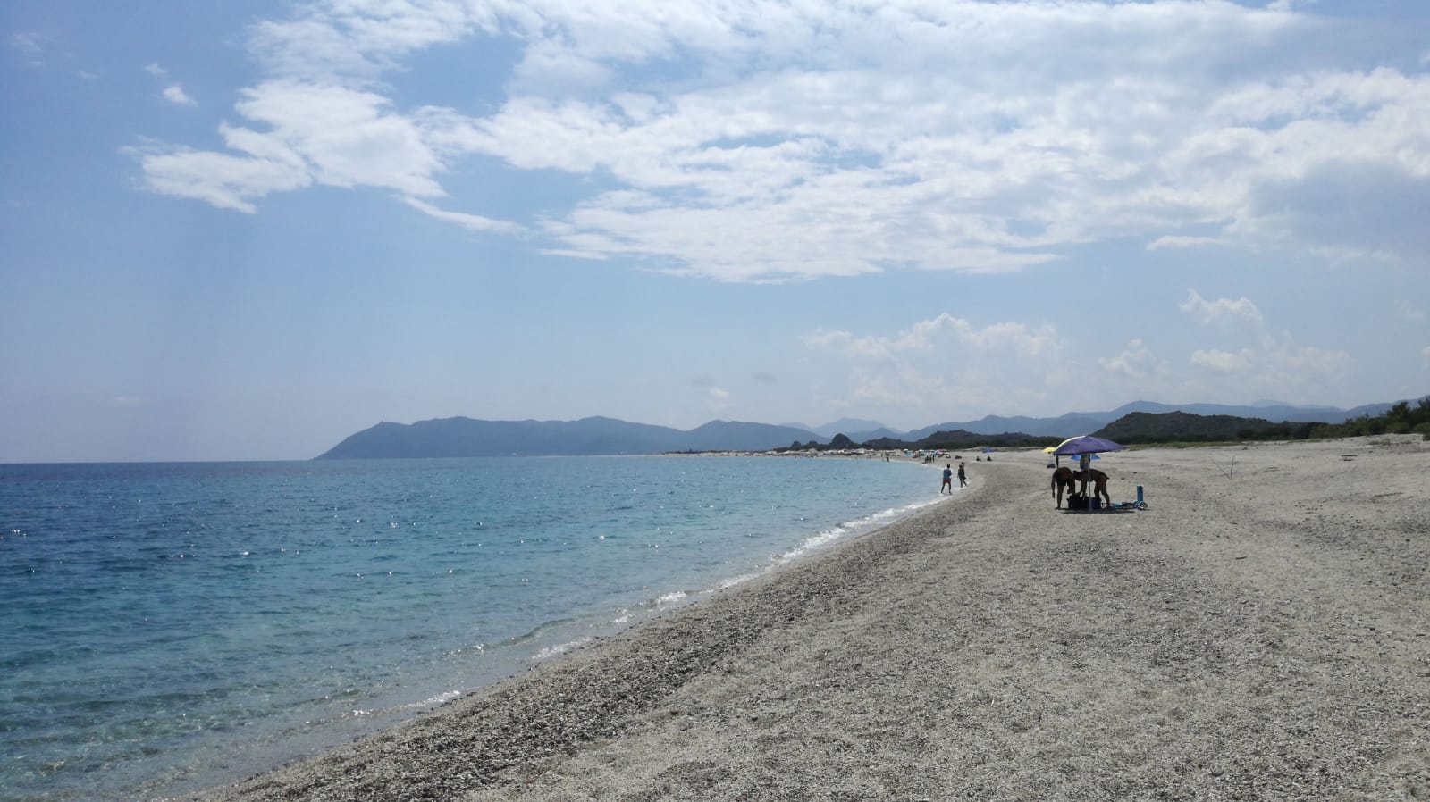
Pedra Longa marks the start of the spectacular, wild Baunei coastline, one of the most striking stretches of the Mediterranean: 40 kilometres of limestone ramparts overlooking waters of shimmering hues, interrupted by coves of pebbles and furrowed by canyons that reach down to the sea, forming beaches of soft, white sand. La Pedra is its only point of interest that can be reached directly by car from a scenic road that joins it to the SS 125 (the Sardinian orientale): you will arrive at a rest area near the rock, with a bar-restaurant. At the base of the outcrop you can relax on a beach of pebbles and rocks. The seabed is characterised by rocky plateaus, which are popular with snorkellers, divers and underwater fishermen. Next to it are the Baus waterfalls, where, according to popular tales, the Saracens refuelled during their failed raid on Santa Maria Navarrese (mid-19th century). You can also visit the huge rock from the sea, on your own or as part of a guided tour with boats departing from the ports of Arbatax, Cala Gonone and Santa Maria.
Villaputzu
Its ancient roads and stone houses match the shape of the mouth of the Flumendosa river. Villaputzu, a village with five thousand inhabitants, lies a short distance from the southeastern coast of the Island, along which there are stretches of sand and promontories with inlets. Four kilometres from the village, you will find the marvellous Porto Corallo and its modern tourist port, dominated by a tower, which is one of six making up the Aragonese defence system (16th century). Nearby, there is the captivating Porto Tramatzu: fine sand set in Mediterranean greenery. Further north, there is the beach of Quirra (or Murtas), which is only partly accessible due to military restrictions. Next to the coastline, alluvial plains with ponds open up and are the habitat of the western swamphen, the mallard and the greater flamingo. This unspoilt scenery combines sun and sea with birdwatching, biking and trekking. As you explore further, you will encounter dense woods: you can walk amidst the ruins of industrial archaeology, like the mine of Baccu Locci, and grottoes with intricate underground passages, stalactites and stalagmites.
Villaputzu's origins can be identified with Phoenician-Punic towns and the river port of Sarrapos (hence the name Sarrabus), dating back to the 7th century BC. It later became a Roman village, as is documented in the Itinerarium Antonini. The current village gravitates around the parish church of Santa Caterina of Alexandria. The Late Gothic church of San Giorgio Martire is also worth visiting. It was rebuilt in the 16th century on a previous 12th century structure. Among the rural churches, that of San Nicola stands out. It is a very rare example of a Sardinian Romanesque red brick building. The little church stands at the foot of the mountain of Castello di Quirra (13th century), places in which historical tales are told of sieges, along with legends about the Carroz family. The mountain has seven caves on different levels, where artefacts from the Palaeolithic era and from Roman and Medieval settlements have been found. There are infinite traces of prehistoric times in the territory: Domus de Janas necropolis of Torre Murtas and of S'Oru, underground interment of Casa Forrus, Pseudo-Nuraghi, single-tower and complex Nuraghi, Tombs of Giants and the sacred well of Is Pirois, built on the top of the Nuraghe.
The Fires of Sant'Antonio Abate, the carnival and the festivity of San Giorgio (in May) animate the village and the festival of the launeddas, in August, is the event par excellence: players from all over the island perform here. A similar concert, Canti di Canne, is staged on 26 December at San Giorgio. The musical instrument, consisting of three pipes played using the 'circular breathing' technique, has primordial native origins. Villaputzu boasts centuries of use of this instrument: skilled masters hand down this priceless heritage to young players. On the subject of traditions, you can admire fabrics, wicker baskets, wooden and ceramic objects in the summer, during the Sarrabus handicrafts exhibition. Citrus fruits stand out among the agricultural products. The exquisite cuisine is the result of ancient customs: culurgionis and malloreddus, char-grilled meat and fish and pastries like pardulas and pabassinas.