

Nuraghe Santu Miali
Its walls have seen a succession of Nuragic, Punic, Roman and early medieval peoples, making it one of the few Sardinian Bronze Age sites that ‘lived’ uninterruptedly for more than fifteen centuries. The nuraghe Santu Miali is located in the territory of Pompu, a small agricultural village in the upper Marmilla area, at the foot of Mount Arci, and has undergone numerous excavation campaigns over the years, which have shed light on its extraordinary longevity. The building falls into the category of Nuragic fortresses with a complex structure, consisting of a central tower and a quatrefoiled bastion with an inner courtyard. Its construction dates back to between the 14th and 12th centuries BC. The construction material used was sandstone, giving Santu Miali its distinctive yellow colour.
Around the nuraghe, you will notice the traces of a dozen circular huts, belonging to the village, and another two buildings identical in shape but larger in size, positioned on the north and east sides of the nuraghe. All the buildings are surrounded by a rampart. In the southern section of the curtain wall, the isodomic construction technique stands out, with perfectly squared blocks and the use of ‘L-shaped’ corner ashlars in some places.
In the centuries that followed, the courtyard became a sacred area: this is demonstrated by the numerous and surprising discoveries made during the excavations. In particular, the lamps present symbols referable to various cults and religions: perhaps Ceres, the goddess of the harvest, was celebrated. However, some also show the cross with a P, relating to Christianity, and the symbol of the Menorah, which instead refers to Jewish rites. Santu Miali therefore represents an important example of religious influences and tolerance. Traces dating back to the early Middle Ages were also found in the huts surrounding the nuraghe, while there is a tomb dug out of the limestone rock nearby, known as su Laccu de su meli, as well as the remains of necropolises and residential areas, all dating back to Roman times.
The rich obsidian deposits of Mount Arci have been exploited since the times of the Pre-Nuragic populations, who left traces of workshops and processing stations in the entire area. In the area around Santu Miali, three workshops have so far been identified, but further evidence comes from the locality of Prabanta, on the border of the territory of Morgongiori. Here, you can visit the archaeological complex of the same name, where there is a menhir of three and a half metres, su Furconi, and two Domus de Janas, sa Sala and su Forru de Luxia Arrabiosa. Not far away, between Pompu, Morgongiori and Siris, there is also the three-towered nuraghe su Sensu.
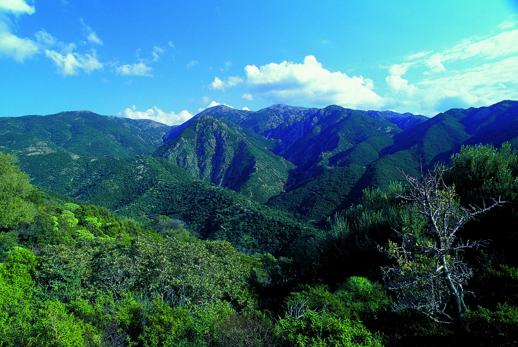
Marganai
It is one of the richest and most captivating green areas in the south of the Island, to be visited by following evocative trails. The state-owned forest of Marganai, in the Sulcis area, occupies 3,650 hectares of the territory of Domusnovas, Fluminimaggiore and Iglesias and it is also part of the park that unites Monte Linas and Montimannu. In spite of intensive exploitation by humans, its scenic beauty is still intact.
The mountainous massif, made of limestone and schistic rock and among the most ancient in Italy, has uneven peaks that range from two hundred to one thousand metres in height, covered by lush forests of holm oaks, which are original, and pines, planted during the reforestation. Next to it, there is dense Mediterranean scrub: olive, mastic, wild olive and strawberry tree.
Amidst the green of the trees and the rushing of the streams - Sarmentus, Sa Duchessa and Oridda - that flow alongside trails, you will notice species like the wild boar, the wild cat, the hare and the fox. In some areas, the Corsican red deer and the mouflon have been reintroduced. Furthermore, the peregrine falcon and, more rarely, the golden eagle, fly over the forest. In summer, it is transformed into a refreshing oasis in which you can spend relaxing days walking in the shade, admiring the scenery of the valleys on which the forest lies or taking organized tours, either trekking or on horseback.
Among the attractions not to be missed in Marganai, there is the botanical garden of Linasia, that has an immense wealth of forest flora, and there is also the Grotta di San Giovanni, one of the longest natural tunnels in Europe. It is a grand monument, the only example in Italy of a cave through which a carriage road crosses, parallel to the Rio Sa Duchessa, under a high limestone rock face where numerous archaeological remains have been found. In 2010, the Garden of the butterflies was also created, an enchanting journey into the world of the lepidoptera, fascinating for enthusiasts and for families with children.
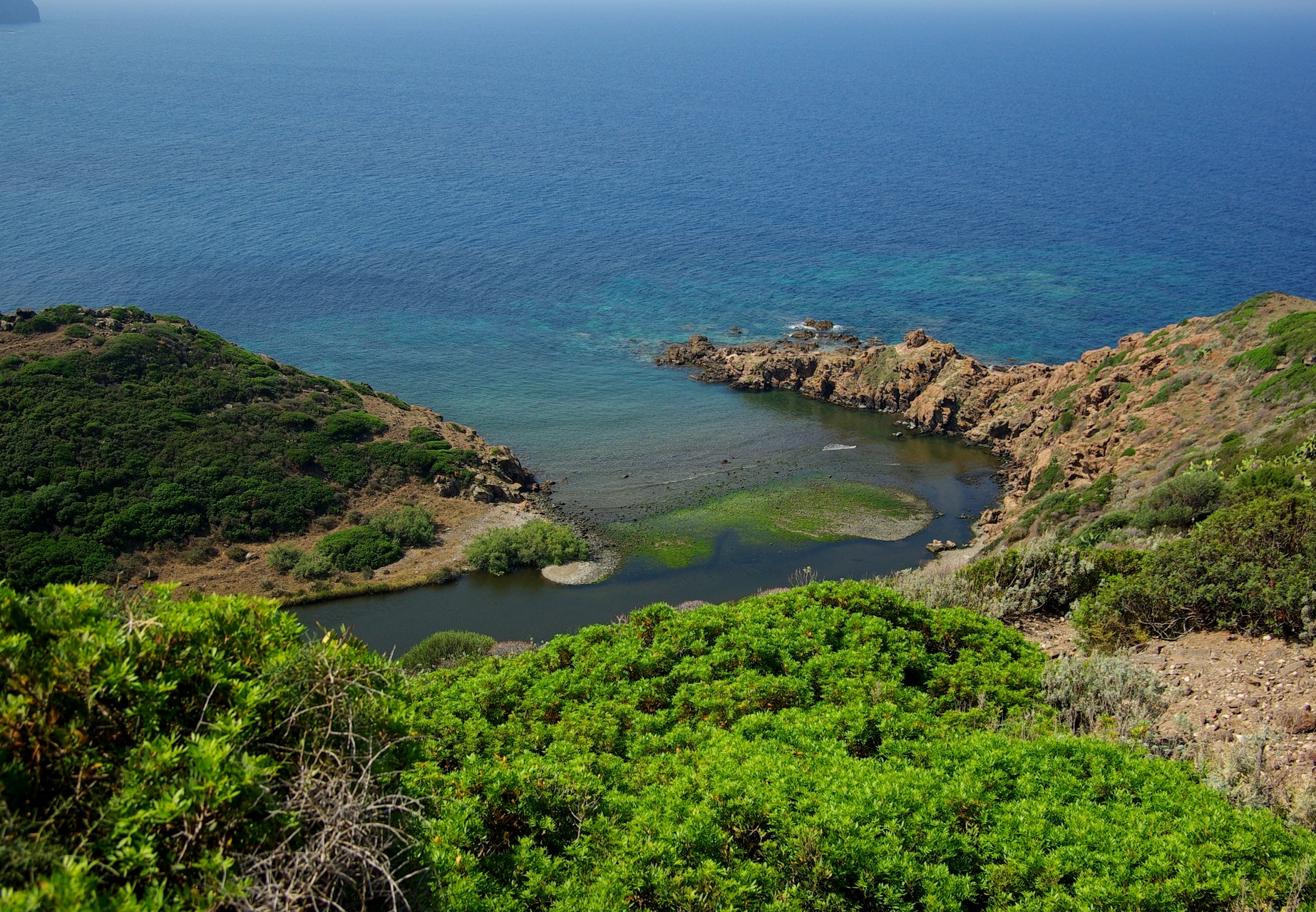
Punta Foghe
The volcanic activity of the massif of Montiferru provided the raw material, creating the plateau. The waves of the sea and the current of the Mannu river, which flows here, have shaped its features. Punta Foghe is the spectacular result of thousands of years of erosion patiently carried out by nature: the plateau ends in a precipice overlooking the sea, creating an impressive rocky cliff, with islets and little coves that enhance its appearance. It is also the river that makes the scenery unique. Before flowing into the sea, it ‘swerves’ to the south, unable to erode the basalt of the cliff. Between the last stretch of the river and the sea, there is a bed of pebbles, which partially emerges, creating a distinctive barrier.
You can reach the main cove - near the mouth of the river - by following the path that starts at the foot of the Foghe Tower, a Spanish watchtower built at the end of the 16th century and abandoned in the middle of the 19th century. It is about ten metres high, made of basalt ashlars and red vulcanite and has a circular vaulted-dome room with a fireplace, while on the outside there is a flight of steps carved out of the stonework, allowing access to the terrace. From here, you will have a captivating view that extends from the other Spanish towers built above the coves of s’Ischia Ruggia and Columbargia and the spectacular sea stacks of Corona Niedda. Behind it, you can admire the Mediterranean scrub, formed by junipers, lentisk trees and prickly pears, that slopes down towards the reefs. The sea in front of the cliff is crystal clear, reflecting shades of green and blue, and is perfect for diving, underwater fishing and snorkelling. On the beach, you will be surprised by the river landscape that fades into the rocky coastline, with dark pebbles and rugged basalt rocks, surrounded by reed beds and frequented by birds of prey and sea birds, such as vultures, cormorants, peregrine falcons and Eleonora's falcons.
The central-western coast of Sardinia offers further scenarios not to be missed: south of Punta Foghe, in the territory of Cuglieri, you can admire the enchanting waterfall of Cabu Nieddu, with a drop of forty metres directly into the sea and very few equals in the world. In the little village of Santa Caterina di Pittinuri the limestone arch of s'Archittu and the nearby beach of ochre-coloured sand with golden reflections await you. To the north, you can relax on the wide expanse of multicoloured sand at Porto Alabe, in the marina of Tresnuraghes.
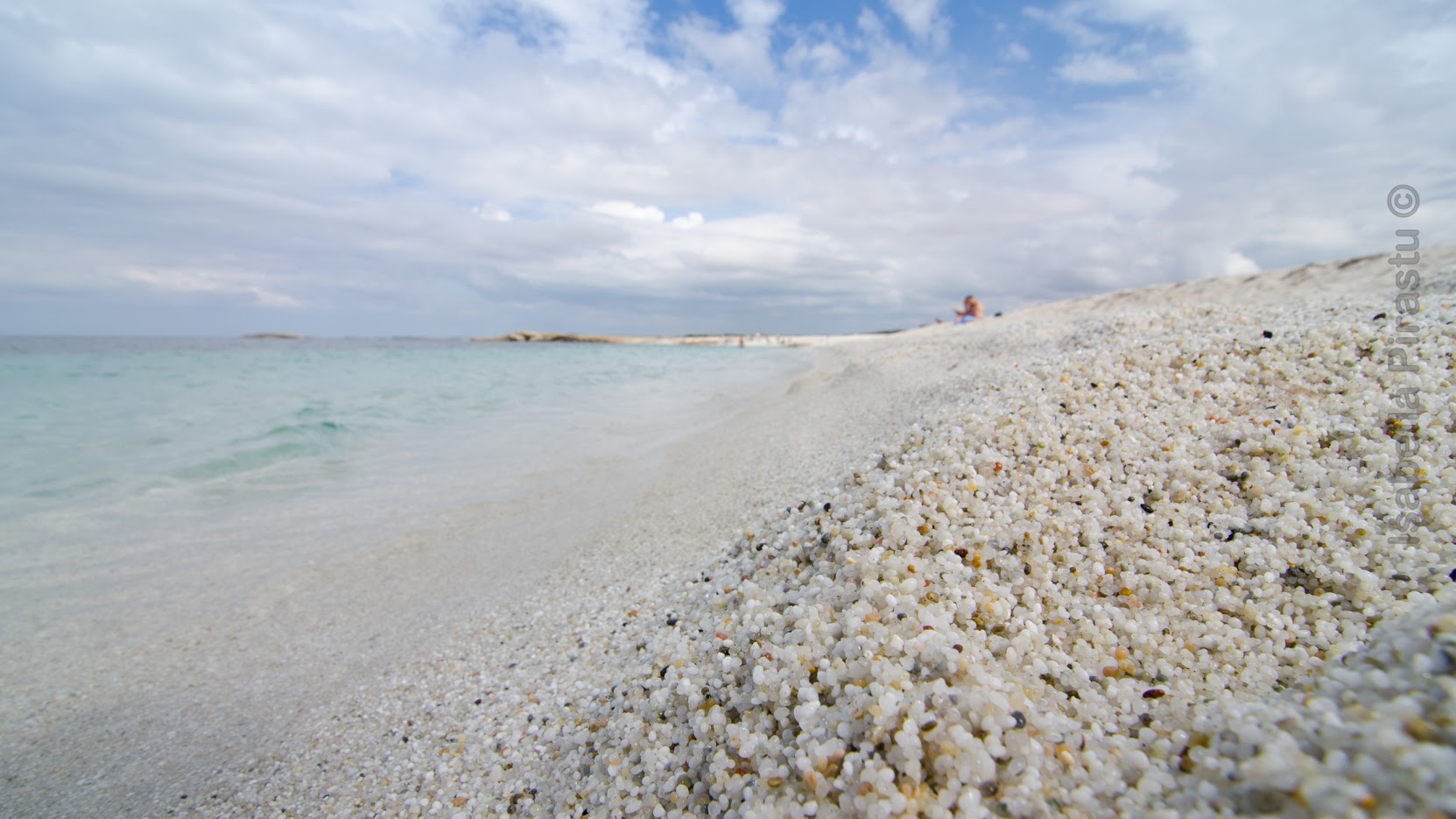
Is Arutas
Various hundreds of metres of turquoise sea and grains of ultra-thin quartz, similar to grains of rice, in a beautiful palette of colours ranging from green to white and delicate pink. Is Arutas is one of the jewels of the marine area of the Sinis peninsula, in the Cabras territory, only a little over ten kilometres to the north of the inhabited town. This beach is perfect for those who love to relax in a dreamy landscape: to reach it, you must cross the village of San Salvatore, famous for its Corsa degli Scalzi (Barefoot Race) and for being the scenario of several Spaghetti Westerns.
Do not forget to carry a camera and a snorkelling mask with you: the sea bottom is deep right from its first metres, and takes on an intense green and azure colour that gradually turns into blue. The clear waters allow for a sharp view of the marine species that inhabit the area. You will see schools of confident little fish that will shyly swim near the posidonia formations, and discover submerged natural treasures. In some of the small bays of the long beach, you can admire segments of coast with sand made up of ultra-white rice grains and crystal-clear pure water. Like the entire coast of this part of the Gulf of Oristano, this is one of the most popular beaches among windsurf and kite surf aficionados. You will find parking areas, kiosks/bars, and a camping area.
Slightly more to the north of Is Arutas, there is a “twin” jewel: fine golden sand with tiny pebbles of white and pink quartz characterise Mari Ermi, whose multiple ever-changing hues cover two and a half kilometres, all the way to Porto Suedda, where rocks appear, hiding another small beach.
In front, you will notice the characteristic shape of the Mal di Ventre Island, a protected natural paradise where sea turtles lay their eggs and in whose depths several wrecks of different time periods abound. Going south, before the ancient town of Tharros, where you can combine a day at the beach and a fantastic archaeological visit, you will find the Maimoni beach, it, too, with light sand sparkling with quartz fragments.

Milis
Famous for its orchards of citrus fruit, oranges in particular, planted by the Camaldolite monks who settled here in the XIII century building the churches of San Paolo, San Giorgio di Calcaria and San Pietro in Vincoli. Milis is an important agricultural town of more than 1,500 inhabitants nestled in a valley rich with streams and brooks, near the Montiferru mountain range, and lends its name to the northern part of Oristano’s Campidano region. Its name may have come from miles, or soldier, when it was a Roman military settlement. It boasts some well-preserved prehistoric remains in the form of various nuraghe: Cobulas and Tronza along the banks of the riu Mannu.
The verdant landscape is rendered fertile by an abundance of streams and rivers. Orange groves abound and every February a citrus festival is held. Other fine foodstuffs are also grown and made here: cereals, honey and Vernaccia wine. The year’s main event is the Sardinian novello wine festival in November, featuring food and wine, as well as cultural activities. In mid-March, during the feast of San Giuseppe, there is also the chick pea festival. While August boasts an ethnic music and dance festival, La Vega.
At the centre of town is the XVI century Gothic-Aragonese parish church of San Sebastiano, and, facing it, Palazzo Boyl, built by the marquises of Boyl (relatives of the ruling Savoy family) in the early 1800s, an expansion of a noble home from the XIV century. It was the summer residence of such illustrious figures as kings Charles Felix and Charles Albert, of Grazia Deledda, Gabriele D’Annunzio and, in 1838, Honoré de Balzac. It is a fine example of Piemontese Neoclassic architecture with an entrance gallery and Pompeii red façade. It is now home to the museum of Sardinian dress and jewellery, an ethnographic display of textiles, garments and ornaments that cover two centuries of history. In the same building and in casa Murru is an exhibition of ancient agricultural tools. Villa Pernis, an 1800s home, is also very interesting. Just outside of town, set among the citrus groves, is the spectacular two-colour – alternating layers of light limestone and dark basalt –façade of the fine Romanesque church of San Paolo. It was built between 1140 and 1220. It houses paintings from the Catalan school, a baroque altar and wooden statues. The grounds host a war cemetery. Buried here are the remains of soldiers and civilians who fell in the Second World War when Milis was home to an invisible military airport, invisible because it was camouflaged by the orange groves. The church of Santa Vittoria has an important XVII century wooden altar and tombs dating back to the VI and VII centuries. The Boyl family gave the sanctuary the stretcher on which the statue of Jesus is carried during s’Icravamentu, the heartfelt ritual during Holy Week.
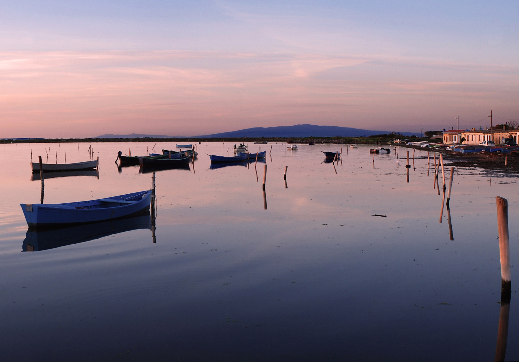
Laguna di Marceddì
A fishing village arose in the southern part of the gulf of Oristano, in an extremely sheltered position, at the base of the 'horn-shaped' piece of land that ends at the charming Capo San Marco, the southernmost limit of the bay and the border with the Costa Verde. The typical dwellings of the small village, in the territory of Terralba, stretches as far as the pine forest of the salt water lagoon of Marceddì, which originated from the marine inlet. The internal part of the lagoon, separated by a small barrage, is a pond that goes by the name of Stagno di San Giovanni. The rivulets of Rio Mogoro and Rio Mannu enter here, making the water less brackish. Along the village promenade there is a harbour and a church dedicated to the Virgin Mary of Bonaria, which - in the second half of August - becomes the scene of a festival that sees a stirring procession, taking place on the sea. The simulacrum travels along the pond, on board a fully-decorated fishing boat, followed by other boats with groups of believers aboard. Tourists and visitors, then, take part in fish-based feasts and banquets set in the traditional statzusu.
The lagoon and the pond were once ancient landing places of the flourishing Phoenician-Punic settlement of Neapolis, now the habitat of aquatic birds that nest on the banks covered in lake vegetation: you can make pleasant encounters with purple herons, coots, mallards and western swamphens amidst the reed beds. Whether in the sea, the lagoon or the pond, fishing is by far the main activity: don't miss out on the local delicacies thanks to nearby restaurants and fish tourism facilities, you will find seafood and an abundance and great variety of fish: striped seabream, flathead grey mullet, gilthead bream, sea bream, sea bass and red mullet.
Coast and lagoon blend with archaeology, in a corner of Sardinia that has always been a crossroads of peoples. Confirming this, is the flourishing site of Neapolis, once an important Mediterranean 'market', founded by the Phoenicians, which then became a Carthaginian colony (6th century BC), the remains of which are still visible. Furthermore, a few kilometres away, you can visit the ancient town of Tharros, an archaeological site that tells the story of prehistoric times and the history of Sardinia all in one go. Marceddì has also gone through a recent and more bloody past: it was the stage of pirate incursions. The Spanish Torre Vecchia (16th-17th centuries) was built to protect it from the attacks: you can see its remains on the edges of the pond. From the lagoon, going south, you can easily reach the Costa Verde and its gems - in order of appearance Pistis, Torre dei Corsari, Marina di Arbus, Piscinas and Scivu – and, going north, the beautiful protected areas of the marine area of the peninsula of Sinis, San Giovanni di Sinis, Maimoni, Is Arutas and Mari Ermi.
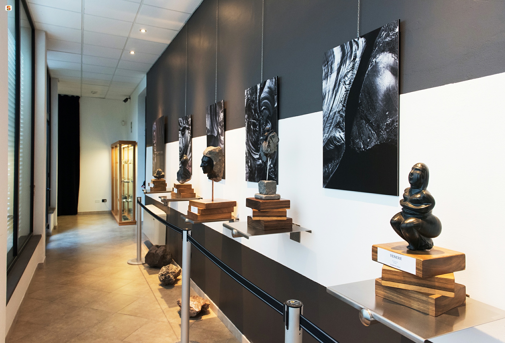
Museum of Obsidian
It is the only monothematic museum structure in Europe, dedicated to the ‘black gold’ of Antiquity, which emerges exclusively in Sardinia within the deposits of the Parco di Monte Arci, a popular destination since the 6th millennium BC for all the peoples of the Mediterranean, flocking to this part of the island to source supplies. In the obsidian museum, at the entrance of Pau, a small village in the upper Marmilla region, you will experience a multisensory immersion into the characteristics and prerogatives of the dark and precious glassy mineral, discovering its evolution, remnants and processing techniques enacted by skilled prehistoric craftsmen to produce weapons and tools. You will be able to discover the society and culture responsible for the first specialised form of ‘mass production’, as well as their impact on the present thanks to the exhibition in the museum’s gallery, with artefacts at times inspired by prehistory, made by contemporary artists such as with the works of Karmine Piras and the Atzori brothers. Minerals and fossils can be admired in the loggia whilst in the village’s piazzas, Guinness-record sized sculptures invoke awe.
The museum pathway and educational workshops are based on direct utilisation, active experimentation and poignant involvement. Inside the exhibition rooms are maps, photographs, diagrams, interactive audio-visual media and, above all, the ‘self-managed’ perception, visual and tactile, with videos projected onto the walls and sounds diffused within the rooms, evoking the resonance of the work. An excursion to the obsidian park, on the eastern side of Monte Arci, will complete your experience, travelling along the picturesque paths where you can appreciate the landscapes with lush forests and outcrops of the precious volcanic rock that frame the workshops.
The mineral was of extraordinary importance for Sardinian prehistory, given that the objects produced in the Arci massif were found in Neolithic settlements in Sardinia, northern Italy and southern France. In the volcanic complex, at least three known obsidian flows exist whilst in the Pau territory of obsidian nodules and chipping products extend over an area of more than 20 hectares. The machining centres were in Sennixeddu, Fustiolau and su Campu Serrau. Walking along the trail of sa Perda Crobina in Sennixeddu, trekking for an hour-and-a-half, means stepping upon thousands of fragments. The town was home to one of the largest workshops and is rich in left-over chippings. Rough-hewn obsidian was processed and then transported to nearby villages, with one likely contemporary Neolithic settlement being identified 350 metres further east. General Alberto La Marmora, in his 19th-century ‘Itinerario’, stated that he had not seen such a quantity of shiny black stone anywhere else: “The traveller sometimes has the impression of walking on the fragments of an old black bottle factory.” The first indications of the systematic exploitation of the resource by specialist ‘chippers’ date back to the recent Neolithic period (second half of the 5th millennium BC), when the great workshop of Conca ‘e Cannas was established. Production continued (with some breaks) for over three thousand years, until the Bronze Age.

Piscinas - Costa Verde
This wonderful oasis far from everything, with imposing and sinuous dunes of fine, warm golden sand that reach up to 60 metres in height, is shaped by the mistral winds and extends several kilometres from the hinterland until diving into the boundless and shimmering blue sea. Piscinas, a jewel of the Costa Verde - in the territory of Arbus - is like an oriental painting, presenting a breath-taking landscape and a must-see beach on your island holiday, considered by National Geographic as being amongst the most beautiful in the world. After walking along the unpaved and sandy trails, you will suddenly spy the immense and deep golden expanse, extending seven kilometres. The sea and sky merge along the blue horizon, whilst the shimmering sand dunes - declared a World Heritage Site by UNESCO - blend with the colours of the Mediterranean scrub. The vegetation grows lush with centuries-old junipers bearing twisted branches, lentisks and olive trees that form small groves and, in spring, violets, sea lilies and sand poppies. Here, the Sardinian deer occasionally roams, whilst the sea turtles lay their eggs on the shore.
Its dimensions ensure a tranquil insulation at all times. Not surprisingly, a large stretch (around 800 metres) has officially been determined as the largest natural beach in Europe since 2018. The towns are located far away and there are few accommodation facilities aside from a campsite and a hotel close to the dunes. Along the sandy shore, you will find two panoramic kiosk-restaurants. You can also rent beach equipment, canoes, skates and dinghies. The parking area is also equipped for campers.
The clear seabed plunges to great depths almost immediately in a stepped formation. From a minimum of two to three metres, it soon reaches tens of metres. By diving, you can explore the site where the wreck of an English ship 'rested' for three centuries, 200 metres from the shore. The mouths of two streams attract fish close to the shore in the hunt for mullets. If you are a surf casting enthusiast, you will be pleased to discover that striped sea bream, shi drum and sea bream populate the waters. The wild sea of the Costa Verde is rarely calm and always to be respected. The constant wind raises long and high waves, making it a beloved destination for surfers, with windsurfing, kitesurfing and surfboarding enjoyed here even in winter.
Reaching Piscinas via Guspini or Arbus means undertaking a journey back through the centuries, imbued with memories of mining activities, as witnessed by the Rio Piscinas that takes on a reddish colour as it flows by. The road from Ingurtosu leads to the sea, through the valley of is Animas. The village, now a ghost town and part of the geomineral park of Sardinia, was the hub of nearby mining activities for over a century, belonging to the Montevecchio complex. With its Wild West atmosphere, you will see the remnants of mining settlements, including the residence of the director and the managerial building, church and hospital, the ruins of housing and the construction sites with wells, installations and washeries. The road descends steeply between mountains of scrap materials, rusty trolleys and abandoned wagons from the railroad once used to transport the minerals to the docks on the beach.
The dunes are characteristic of the entire Costa Verde. In addition to Piscinas, you can visit other “Saharan” environments sculpted by an exceptional sculptor - the relentless mistral wind. In Torre dei Corsari, a little further north, you will be dazzled by the mixture of the golden sand, the silver rocks, the turquoise and green of the sea and the vegetation. On Sabbie d’Oro of Pistis, the northernmost beach on the coast, the two kilometres of soft sand are surrounded by junipers, lentisks and olive trees. In Sivu, yet another jewel of the Mediterranean, you can admire three kilometres of dunes and turquoise sea, sensing a deafening silence, interrupted only by the undertow and the cries of seagulls. The beach is said 'talk' due to the echo that can be heard when walking along its extent. Another immense sandy expanse that also extends two kilometres in length, is the Marina di Arbus, with its melody of colours often leading to comments about being the “Caribbean of Sardinia”. Set between “Torre” and “Marina” are Portu Maga and Funtanazza, once a holiday destination for the miners' children. The extreme southern tip of the Arbus coast is Capo Pecora, a destination for scuba fishermen.

Gonnostramatza
In 1388, the Giudice Eleonora d’Arborea chose Gonnostramatza as the location for the signing of the peace treaty with Pietro IV of Aragon. Until the 17th century, Gonnostramatza was the most populated and important town in Marmilla, nestled in a valley brimming with vineyards, olive groves and almond trees, crossed by the river Mannu that divides it into two districts, ‘big’ and ‘small’, with three bridges to ensure transition from one to another. The historic centre preserves ancient houses with typical Campidanese architecture. One highlight is the parish church of San Michele, famous for its aps that houses the Retablo dell’Annunziata by Lorenzo Cavaro from 1501, progenitor of the family of painters from Cagliari who gave life to the school of Stampace (16th century). The large altar table, coming from the Chiesa di San Paolo in the hamlet of Serzela (today a ghost town), consists of three vertical and two horizontal upper components, each divided into various sectors. Scenes from the life of Christ, of the Madonna, archangels and saints are represented. The church, built between 1680 and 1715 on the site of a pre-existing construction in Gothic-Aragonese style (as attested to in 1524), maintains a cross-vaulted apse and part of the sacristy of the old building, all being the result of a restoration project undertaken after the second world-war. The main body has three chapels on each side. The high façade is punctuated by rows that create a chiaroscuro effect. Alongside is a square-shaped bell tower, covered by a dome with coloured tesserae. The feast of the patron saint, with religious and civil events, takes place in August. Another religious building is the Chiesetta di Sant’Antonio on the main street. In the countryside is the Chiesa di San Paolo, once a parish church of Serzela, dating back to the 13th century and rebuilt in the 17th century. A tragic reminder of the destruction of the nearby village of Uras by the Saracens led by Barbarossa is inscribed on a plaque preserved in the local sanctuary. Linked to this is another cultural site, the Museo Turcus and Morus, inside the restored Monte Granatico, dedicated to the Barbarian raids. Models of coastal towers and sailing ships, dioramas depicting raids and battle scenes, panels illustrating events and the protagonists of that ancient tragic war.
Prehistoric remnants are not lacking in the countryside, with the Eneolithic tomb of Bingia e Monti. Here, a prehistoric necklace was found, the oldest gold necklet found in Sardinia. The enhancement of the archaeological sites is overseen by Gonnostramatza united with 19 Municipalities and the Marmilla sub region and the consortium Sa Corona Arrubia.

Archaeological park of Iloi
A welcoming, scenic plateau has seen various civilizations succeed each other over thousands of years, starting from the Neolithic period. The village of Iloi - pre-Nuragic, then Nuragic - is located at a height of 270 metres and it is probable that the people who inhabited it controlled the territory, which was crossed by numerous rivers at the time. It is also very probable that they celebrated mysterious rituals there and it is certain that they buried their dead there, leaving precious traces. The site, now an archaeological park, is just two kilometres from Sedilo and dominates the ancient Tirso river valley, with a panoramic view of the northwestern shore of Lake Omodeo.
The complex nuraghe takes centre stage inside the park, a construction with three towers, with a trapezoidal body leaning against it, which perhaps represents the original core of the structure, to the point of assuming that it was a corridor nuraghe, dating back to between the end of the Early Bronze Age and the beginning of the Middle Ages. The trefoil building, on the other hand, was built in several phases, up to the Late Bronze Age, and has a concave-convex shape. The eastern tower is the best preserved: when going in through an architraved entrance, you will see a vaulted tholos chamber with a niche and the traces of an obstructed passage on the left wall. You will also notice a large stretch of curtain wall that connects it to the north tower, which is inaccessible due to collapses. The keep still has the first rows of basalt blocks up to two and a half meters in height.
Around the nuraghe you will see numerous circular constructions. These are the remains of the huts of the Nuragic village, which originally extended for about two hectares. Some of them had cult functions, while others were positioned around a common open space. The ‘cemeteries’ of the Nuragic peoples of Iloi were two Tombs of Giants. The outline of the corridor of one of them, not yet investigated, can be distinguished; while the other is well preserved and has the classic layout: a central apsidal body, a covered funerary corridor and an exedra façade, in which you will notice a counter-seat interrupted by a circular platform near the entrance. The floor of the corridor is paved with slabs.
About 300 metres from the Nuragic remains, going down to halfway up the plateau, you can see the most evident traces of the populations who preceded them: these are the 33 domus de janas that form the necropolis of Ispiluncas, dug out of the tuff in the Late Neolithic period. The domus, divided into two groups, are partly multi-cell and partly single-cell. ‘Tomb 2’ is divided into 13 rooms and shows traces of red paint. ‘Tomb 3’ has a central quadrangular room around which there are secondary rooms. Both burial areas were used until the Early Middle Ages. Since 2025, together with 16 other sites, the necropolis has been included among the Sardinian Unesco World Heritage Sites.
The park of Iloi is the maximum archaeological expression of the territory of Sedilo, which is also very rich in places of naturalistic interest: the area around the Omodeo is ideal for trekking excursions and its waters are perfect for canoeing. Another major attraction, just outside the town, is the sanctuary of San Costantino, where the unbridled horse race Ardia takes place in July, surrounded by cumbessias, the lodgings intended for accommodating pilgrims.