

Santa Maria
The pearl of the far north of Sardinia, the closest to the Strait of Bonifacio, on the border with Corsica. Together with the two other splendid islets of Razzoli and Budelli, Santa Maria represents the northernmost part of the La Maddalena Archipelago Park, one of the destinations not to be missed on your tour of about 60 islands. The surface area of the islet is two square kilometres, while it has a ten-kilometre perimeter of jagged coastline. The characteristic that makes it stand out from the other minor islands of the Maddalena Archipelago, is that it is the only one that is permanently inhabited, obviously apart from the big ‘sister’ La Maddalena. You can reach it in about twenty minutes by boat from the port of La Maddalena or that of Palau.
The morphology of Santa Maria also distinguishes it from the nearby islands: it has no elevations and the highest point is Guardia del Turco, just 49 metres high. So you can walk through nature, crossing paths surrounded by low Mediterranean scrub. Along the ‘internal’ paths, you will come across the ruins of a Benedictine monastery built in the first half of the 11th century and a place of seclusion and prayer for the monks. It was abandoned in the 16th century and at the end of the 18th it passed to the Bertoleoni family, who later also took possession of the beautiful Spargi. In the 19th century, the renovated building became a shepherd’s dwelling. Today, other homes are present on Santa Maria and are also used as summer residences by artists and show business celebrities.
Along another scenic path, you will reach the lighthouse of Punta Filetto, where you can enjoy the view that extends across the open sea to some smaller islets. From the lighthouse, you will catch sight of some coastal pearls, particularly the coves of Cala Santa Maria and Cala di Fosso. The first, which can be reached by sea, has very fine white sand, washed by the uncontaminated sea and with an abundance of marine animals. It is 200 metres long, making it the biggest beach of the entire archipelago. Its shallow waters and sandy seabed sloping down towards the open sea form a splendid natural pool. The cove is surrounded by pink-coloured rocks covered in Mediterranean greenery. Behind the bay, there is a small saltwater lake, the Palude, habitat of numerous species of aquatic birds: woodcocks, moorhens and mallards.
From Santa Maria, you can easily get to the adjacent Razzoli, ‘walking on the sea’ along the Passo degli Asinelli (Passage of the Donkeys), a strip of sand submerged by just half a metre of water. Further north, you will come across the narrower Passo dello Strangolato (Passage of the Strangled one) that separates Santa Maria from the islet of La Presa, which represents the northernmost point of Sardinia. On the island, you will find bathing facilities, hotels and restaurants where you can taste seafood cuisine, as well as authorised charter services for visiting the entire park, including the brightest jewel, the Spiaggia Rosa (Pink Beach), or for doing some fishing tourism or using the services for open sea diving.

Nuraghe Albucciu
A walk through the countryside of Arzachena, the renowned tourist centre of Gallura, will allow you to discover a landscape made of vineyards and pastures, in an area that has been inhabited for millennia and which preserves a rich archaeological heritage inherited from the civilizations that populated the area in prehistoric times. Just two and a half kilometres away from the village of Arzachena, you will find the Albucciu nuraghe , one of the most characteristic and important examples of a 'corridor' building (or protonuraghe), the ancestor of the later nuraghes, although the truncated-ogival rooves were affected by the subsequent tholos building technique .
Dating back to the Middle Bronze Age (15th century BC), the centuries, or rather the millennia, have meant that the nuraghe is completely hidden in a jagged grove of olive trees and Mediterranean scrub. The peculiarity, which differentiates it from the other nuraghes in the area, is its construction technique. The imposing granite blocks were carefully leant against an imposing, light-coloured granite rock that forms part of the masonry of the main building, as well as a preponderant part of the entire nuraghe.
The structure is very well preserved despite some collapses. The layout is irregular, typical of protonuraghes. The shape is rectangular with a north-south orientation and east-facing façade. At the entrance, surmounted by an architrave and open on the large façade, you will see, on the left, a deep closet and a large elliptical room covered with tholos on the right. You will also notice a series of corbels that, in the past, held a balustrade to protect the terrace. Past the entrance, you will see two small niches, one on each side. Further in, you will find a trapezoid passageway, and if you look up you can see a false dome ceiling. On the southern slope is the largest space on the ground floor. The very high roof allowed for a wooden loft that divided the hall into two floors. In the lower one, a mullioned window opens on one side, while a seat on the floor near the fireplace and a wall cupboard still give the nuraghe the impression of 'being lived in'. The upper floor is one of the largest rooms in the entire building: you will enter it via a staircase. It consists of a semi-circular open-air area and a series of rooms, including a large circular chamber, the largest of the nuraghe, accessible only from the terrace. The main daily activities took place on the upper floor: processing of milk and cereals, cooking bread and other foods.
Among the most important findings at the site are a hilted dagger, a statuette of an offeror and a closet of bronzes. These objects allow us to date the Albucciu nuraghe to between the end of the Middle Bronze Age and the Iron Age (around 1400-650 BC). The archaeological area, in addition to the nuraghe, also includes the remains of circular huts, which formed the nuragic village, and 80 meters from the complex the remains of a Giants' tomb called the Moro tomb, probably connected to the life of ' Albucciu. Not far away there is also the Nuragic temple of Malchittu.
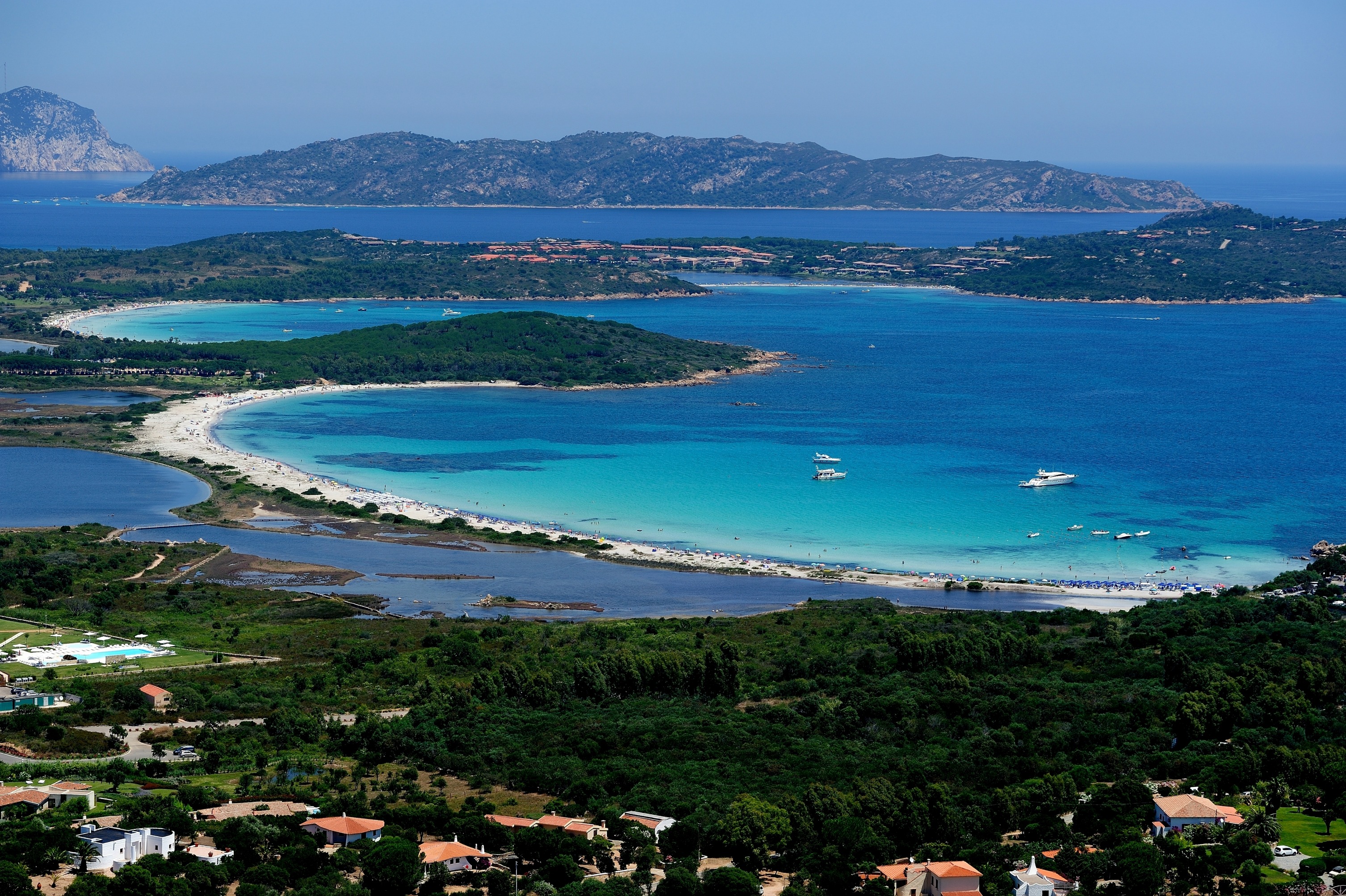
Cala di Budoni
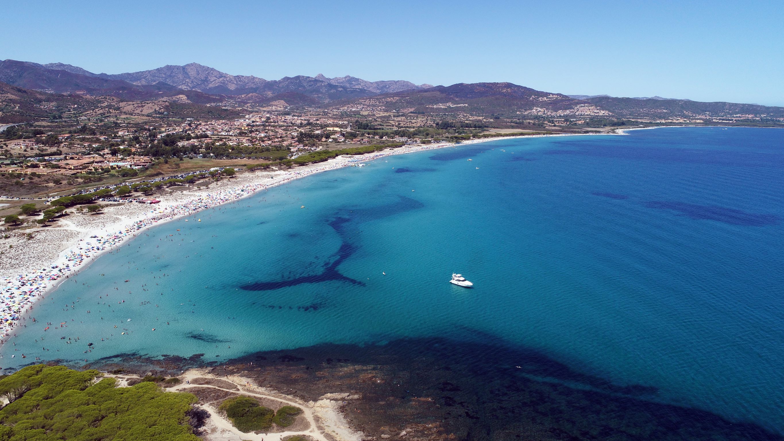
A seaside little town rich with charm, night life, history and traditions, Budoni, a Gallura commune in the border with Baronìa, could not but boast among its pearls a string of dreamlike beaches. Cala di Budoni is, without a doubt, a shining example. About four kilometres long, it goes from Li Cucutti to Porto Ainu, and overlooks a crystalline, shallow sea, perfect for children, with fine and light sand. Along its long and sinuous extension, the coast of Cala di Budoni changes name a few times: Li Salineddi, Salamaghe, Lido del Sole and sa Capannizza.
The beach offers plenty of comforts and services: it is accessible to disabled people and has plenty of parking space. The whole area has many hotels and camping sites, as well as cafés and restaurants. You can also rent beach equipment. The cala is loved by windsurfers, scuba divers and snorkelers.
Nearby, the natural habitat is very varied. The Mediterranean scrub, growing in the midst of the sand, follows the shore and enriches it with green hues. This spectacular scenario also has small dunes, ponds and pine groves, the home of many different species of birds. In the Budoni territory, you will also get to know other pearls of these shores: Li Cucutti, “hills” in Gallura dialect, like those covered in lush green pine groves around the wide beach that meets the turquoise sea; the beautiful yet never crowded beach of Baia Sant’Anna, made of thick golden sand and lapped by crystalline green seawater that becomes deep after only a few steps away from the shore, and cala Ottiolu, near the small Porto Ottiolu neighbourhood, a fantastic beach of white sand that enters the crystalline sea, much beloved and very popular.
Posada
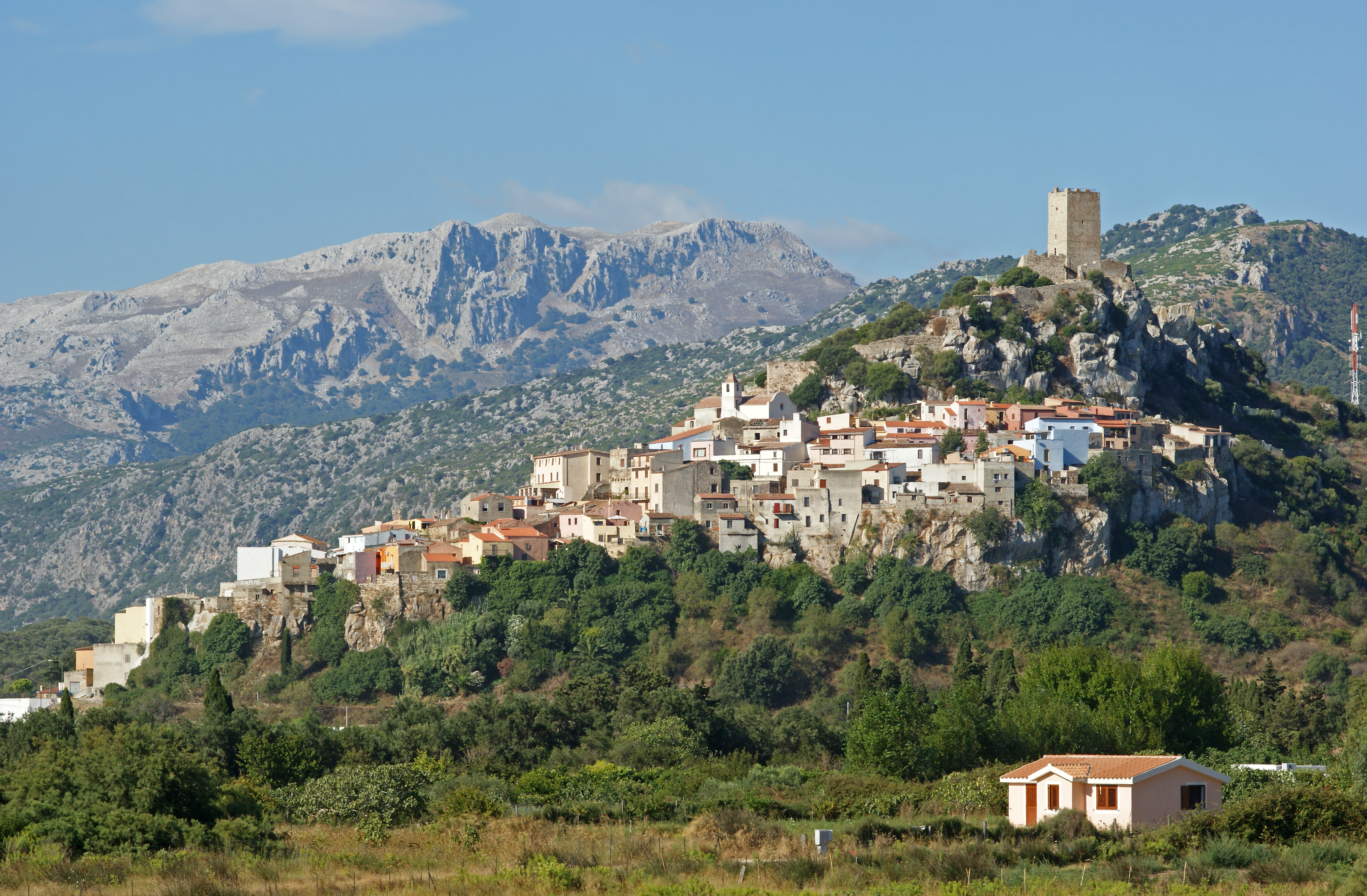
A medieval village perched on a green limestone hill dominated by the Castello della Fava, from which you can admire the splendid panorama of the sea and the surrounding plain. Posada is one of the most beautiful places on the eastern coast and excels for its history, culture and landscapes, to the point that it belongs to the club of the most beautiful villages in Italy. It was built on the ashes of a Carthaginian colony, known as Feronia: in fact, it is one of the most ancient villages on the Island (5th-4th century BC). In vogue, during the Giudicati period, it ended with the advent of the Saracen pirates, who caught sight of it from the sea, like a treasure. The country today still has a Medieval charm and looks like a stone maze made up of intricate alleys, steep flights of steps, arches and unexpected little squares, as if the architecture itself were telling the tale of escapes and reprisals.
A visit to the castle is a must. It was built by the judges of Gallura just before 1200 and was conquered by those of Arborea and then by the Aragonese Crown. Today, the castle is still standing, along with the restored ruins of the boundary wall: a wooden staircase leads to the top of the tower, from which you can see the entire territory. According to legend, the inhabitants of the castle, which was besieged by the Turks, gave their last food, a broad bean, to a pigeon. This is how it got its name. Also worthy of a visit is the parish church of Sant'Antonio Abate, patron saint of the village, dating back to 1324 and rebuilt in the seventeenth century. The best time for a visit is during the celebrations in its honour in January, with huge bonfires and impressive processions.
The nearby coast is heavenly: the beach of San Giovanni di Posada is a stretch of soft, golden sand that is bathed by a turquoise sea; that of Su Tiriarzu has crystal clear water and white sand, surrounded by mountains and framed by white lilies.

Lu Impostu
The most emblematic beach, La Cinta, closes itself up north with Puntaldìa. Right after the promontory, you will find two other San Teodoro jewels, with such beautiful sand and sea that it is hard to pick a favourite. One is called Lu Impostu (“place of shipping”), a name whose origins are unknown – perhaps it was once a trade post and shipping place. What we do know is that it is a natural work of art, one of the main attractions in the Gallura. One kilometre long and very wide, this beach is made of dunes of very fine and soft sand, white and glittery, dotted with juniper trees and mimosas, thistles and sea lilies. The clear water reflects sunbeams, looking anything from azure to green. The shallow bottom is perfect for children; it is mostly sandy and gently deepens as you move away from the shoreline.
The northernmost boundary of Lu Impostu is Puntaldìa, while its southern boundary is with Capo Capicciolu, beyond which another San Teodoro wonder appears: Cala Brandichini. In front stretches the Capo Coda Cavallo peninsula, while a bit further to the north looms the majestic island of Tavolara. Together, they make up a protected marine area that also includes Lu Impostu, behind which lies San Teodoro’s second largest pond, which communicates with the sea through a channel to the south of the beach. All around is swamp vegetation and Mediterranean scrub, helping turn this location into a naturalistic museum. Further south, in the boundary with the San Teodoro territory, a touristic pearl in Sardinia, you will find another beautiful beach, s’Isuledda.
Lu Impostu ensures all amenities and services: it is accessible to disabled people and has plenty of parking space (for campers as well), restaurants, and rental agencies for boats and beach equipment. Nearby you will find camping sites, hotels, restaurants, disco clubs, emergency clinics and information office.
Santa Teresa Gallura
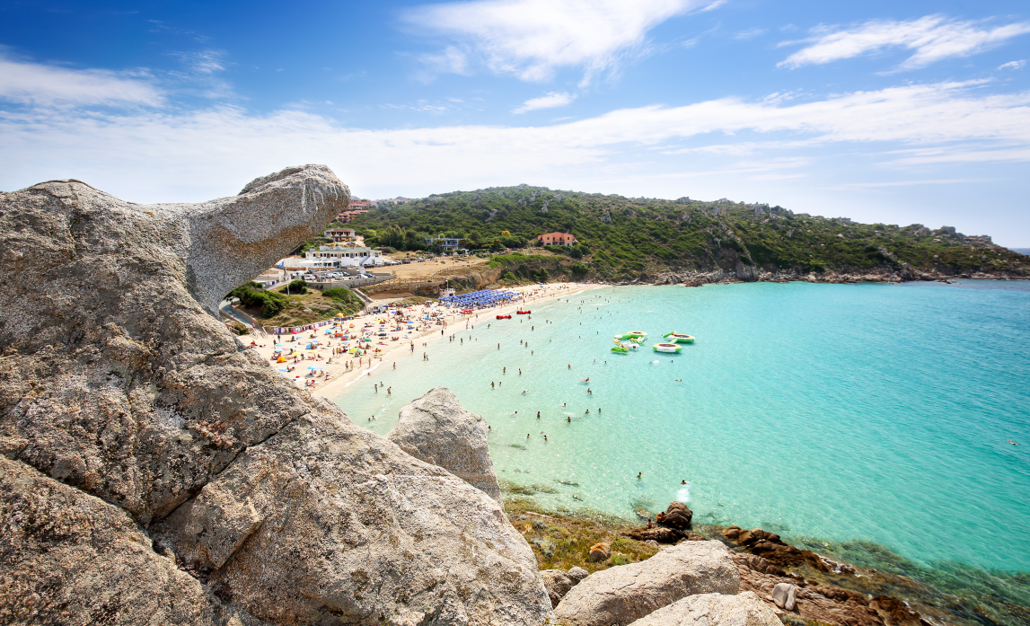
The sea is the undisputed star at Santa Teresa Gallura, a town of about 5,000 inhabitants that in the summer swells to include tens of thousands of tourists who enliven it with aperitifs in chic bars and live music. It looks out over the rocky shore of Bonifacio and was founded in 1808 by King Vittorio Emanuele I of Savoy on the site where the village of Longosardo (or Longone) once stood, then renamed after his wife, Maria Teresa. The town’s edge follows that of two inlets: Porto Longone to the east, where the tourist harbour is, and the bay of Rena Bianca to the west, a stretch of ultra-fine, brilliantly coloured sand located just a short walk from the town’s main square. The crystalline waters here sparkle with a thousand hues, proud recipient of the FEE’s Blue Flag of excellence. Above it rises the historic Longosardo Tower, built at the behest of King Philip II of Spain in the XVI century. There are a variety of other lovely beaches for you to enjoy: the wide La Marmorata, the picturesque Cala Balcaccia and Santa Reparata, known for its particularly clean water and rocky shore, ideal for diving. Heading westwards you’ll come across Capo Testa, the northernmost extremity of Sardinia. Along the isthmus that links the peninsula-promontory to the island are two gorgeous beaches: Rena di Ponente and Rena di Levante. Depending on how the wind is blowing, you can enjoy a calm sea at one or the other. From the western beach you can reach Capicciolu (or the “Beach of Auntie Colombo”) covered in warm golden sand. Here (perhaps) ancient Tibula (and its harbour) once rose, the docks from which ships laden with granite to adorn the palazzos of ancient Rome departed. At the western edge of the cape is the spectacular Cala Lunga - Valle della Luna, the symbol of Santa Teresa Gallura: hidden coves protected by high granite walls shaped by nature. It is the setting for the magical Musiche sulle Bocche music festival, even more beautiful in the soft light of the full moon. When you head towards Palau you will find the natural granite pools of the Valle dell’Erica, the long Porto Liscia-Sciumara, where surfing reigns supreme, and the enchanting peacefulness of the Conca Verde. The splendid copper dome of the XX century church built over the remains of a smaller medieval one glimmers in a romantic stand of pine trees three kilometres out of town. Don’t miss the Batteria Ferrero, the remains of a WWII fortress compete with artillery positions, bunker, garrison and mines. The most interesting remains, however, are the Nuragic ones: Lu Brandali and sa Testa.
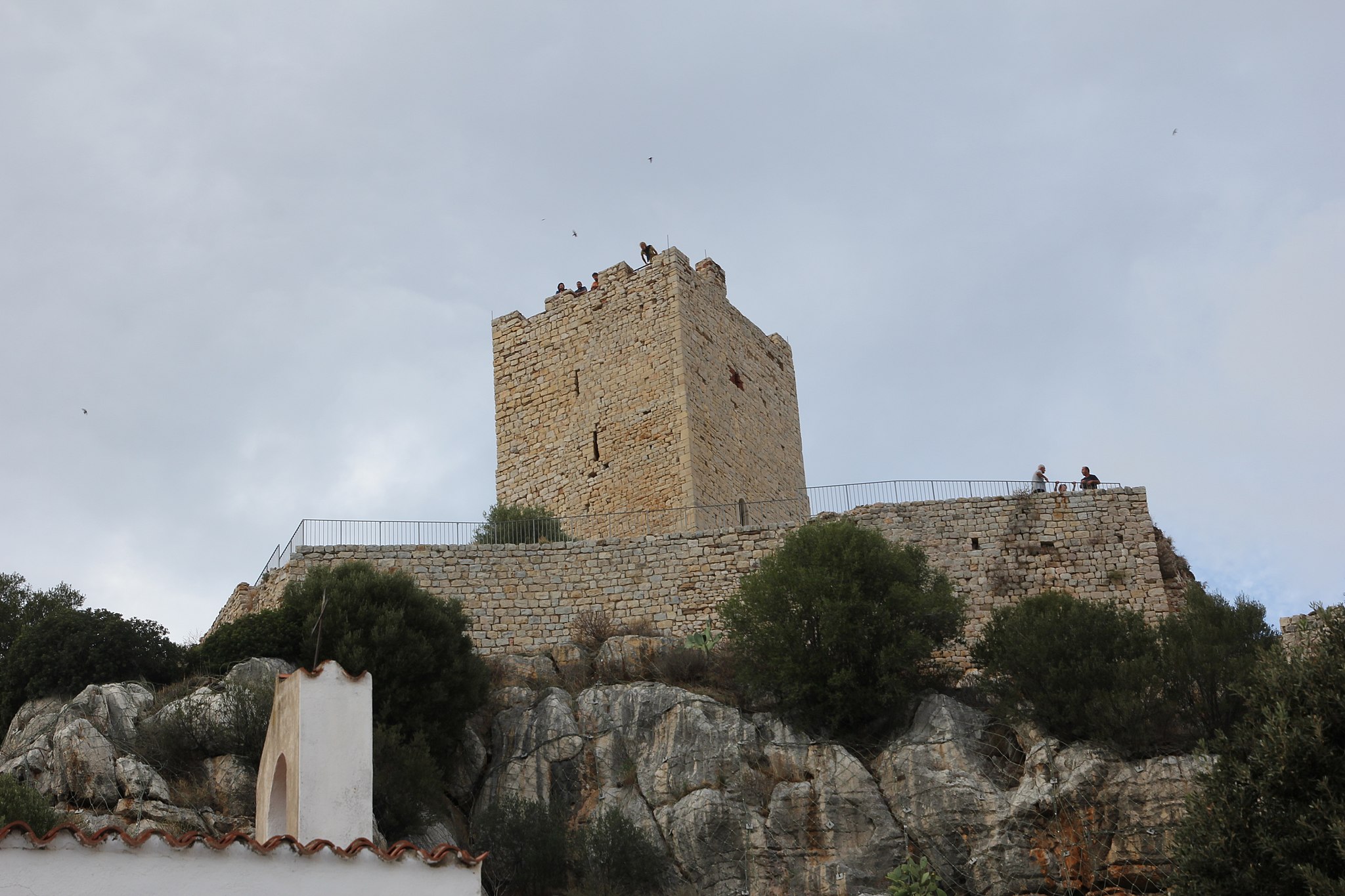
Castello della Fava
In around 1300, a Turkish fleet (or Saracen) besieged Posada, attempting to conquer it through exhaustion and hunger. To deceive the besiegers, the inhabitants of the fortified village – by now exhausted and unable to withstand battle – fed all that remained of their foodstuffs (a handful of beans) to a pigeon. Before freeing it in flight, they wounded him. The bird fell into the enemy camp with a full stomach. The strange swelling was noticed and so was the abundant meal, causing the Arabs to overestimate the resources of the castle, causing them to desist from the siege. It is the legend from which derives the name of the Castello della Fava, a fortress built by the Giudice of Gallura rulers in the 13th century. The legendary tale does not differ greatly from reality. From the 14th century, Posada was the ‘victim’ of raids from Saracen pirates, who spied a treasure from the sea, often coming ashore to loot it. Not by chance, the medieval village – set amidst the league of the most beautiful villages in Italy – is a ‘labyrinth’ of narrow alleys and hidden piazzas. The architecture itself recalls the ambushes, assaults and escapes.
Built with small pieces of barely-worked stone, the castle can be visited, rising atop a verdant calcareous hill, on whose slope the current inhabited centre is perched. Upon making the easy climb up the elevation, the crenelated tower and the ruins of the walls can be admired, the irregular quadrangular layout having once also surrounded a series of cisterns. From the top, a panorama can be enjoyed stretching from the valley of the Rio Posada (which can be travelled along by kayak) to the enchanting beaches around the seaside village of San Giovanni di Posada. This is the territory of the Parco di Tepilora, one of the largest and most beautiful green areas of the island, with paths winding through the forests, springs, lagoons and sand dunes, ideal for trekking and biking excursions.
During the time of the Giudice di Gallura, Posada saw the apex of its historical events, on the border between the Giudice di Gallura and those of Arborea. The two kingdoms long contested the castle and, in 1380, it even ended up in the hands of the Aragonese before returning to the Arborese under the command of Brancaleone Doria. Unlikely to have been a military garrison, but rather a residence for the ruling parties, perhaps even of Eleonora d’Arborea. Some think it was a tourist residence ante litteram. Posada was a borderland even before the Middle Ages, the toponym Pausata meaning ‘staging post’ and ‘frontier location’. Its history began around the 5th century BC on the ashes of the Phoenician Feronia, perhaps an Italic-Etruscan settlement, one of the oldest inhabited areas of Sardinia.
San Teodoro
La Cinta, a long, thin stretch of golden sand bathed by a crystalline blue sea, Cala Brandinchi, a white shore with water that resembles a tropical paradise nicknamed, for good reason, Tahiti, Lu Impostu, its natural progression, the magnificent Marina di Puntaldìa, with its modern tourist harbour and the Caribbean-like s’Isuledda beach. These beaches are the symbols of San Teodoro, a celebrated resort town that is a favourite among young people for its night life. The coastline here is home to a variety of beautiful seashore ‘gems’: Cala Ginepro, its air fragrant with the aromas of the native Mediterranean brush, Coda Cavallo beach, which will amaze you with views of the grand Tavolara and its protected marine area, Cala Ghjlgolu, where the wind and the sea moulded a boulder into the shape of a turtle, an attraction very popular with visitors, especially children. Other places may be less famous, but they are no less beautiful: Baia Salinedda, Cala d’Ambra, Cala Suaraccia, Li Corri di Li Becchi, Li Marini and Seghefusti. The spectacle is completed by, behind the beaches, the San Teodoro lagoon, where flamingos come to rest during migration and home to the long-legged black-winged stilt. It’s a wonderful place for a nice walk and a spot of bird watching.
Known all over Gallura as Santu Diàdoru, this town is home to less than five thousand people in winter, a number that rises to tens of thousands in summer. Although man’s presence here dates to prehistoric times, the town came about in the XVII century, just inland from the eastern slopes of Mt. Nieddu, when shepherds and fishermen populated this amazing stretch of land. The nuraghe in the area of Naracheddu is its most important relic. People had also settled here in Roman times, as documented by archaeological finds now at the Museo del Mare. Among the events not to miss are the festivities surrounding patron saint San Teodoro, whose church was rebuilt in the mid XX century, and festivities of Sant’Andrea, which take place in the Montipitrosu quarter. The bonfires of Sant’Antonio Abate during the Lu Fuculoni festival are especially spectacular, when the faithful gather around the raging flames in honour of their saint. San Teodoro is a town of culinary delights: in May there is the Agliòla, during which local specialities are celebrated. You will love the Gallurian zuppa made with bread and cheese in a tasty beef stock. At meal’s end you’ll be tempted by such delicacies as cucciuléddi milàti, honey rolls, frisjióli léti, fritters and niuléddha, with almonds and grated orange peel. All of it to be washed down with, what else, a glass of vermentino di Gallura!
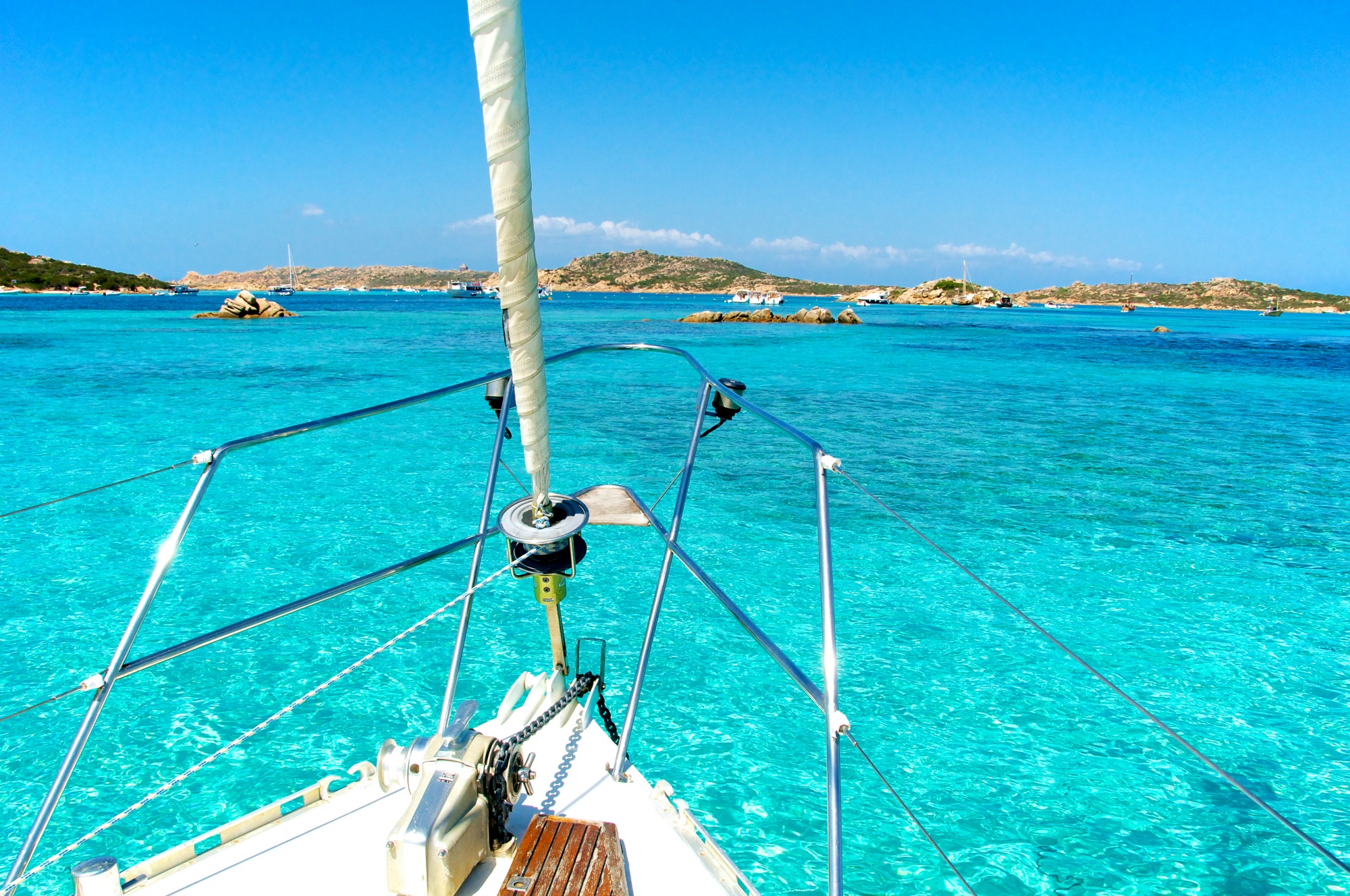
The national park of the Maddalena archipelago
Created in 1994, the first in Sardinia, the national park of the Maddalena archipelago covers more than 20,000 hectares of sea and land. It embraces 180 kilometres of coast and includes more than 60 islands big and small, of granite and schist, sculpted by wind and currents. Among these, the highlights are Budelli, Caprera, Razzoli, Santa Maria, Santo Stefano and Spargi, unforgettable destinations of boat tours leaving from Baja Sardinia, La Maddalena, Palau and Santa Teresa Gallura. Thanks to the many coves, there are countless landing points; the colours of the sea are unique, as are the rocks, sculpted like natural monuments, and the seabed, a diver’s paradise, in particular the shallows Spargiotello and Washington, Punta Coticcio and Grottino di San Francesco.
The park is part of Europe’s network of environmental excellence, and is under extreme surveillance: sports, fishing and diving are allowed, but must be authorised first. It is a beautiful landscape for its morphology and flora. Almost one thousand plant species, 50 of which endemic and others very rare. Its fauna is very particular. The Budelli pink beach, for instance, derives from the sediments of a little organism that adheres to shells, algae and corals. A typical species is the Pinna nobilis, the largest bivalve mollusc of the Mediterranean. The most common cetaceous is the bottlenose dolphin, which you may glimpse in groups of as many as thirty members. Easily found in the park is Caretta caretta, the common sea turtle. Common birds include Audouin’s gulls and European shags.
In addition to Stagnali, in Caprera, the seat of environmental education centres, cetaceous research centres, the Mineralogy and the Sea Museums, which exhibit minerals, fossils, sand, shells, flora and fauna, the only town in the archipelago is La Maddalena, founded in 1770 and for many years a Marine base, as displayed at the Nino Lamboglia Museum.
Among its beaches of clear water and fine sand, do not miss Bassa Trinita, Cala Francese and Cala Lunga, Monti d’a Rena, Punta Tegge and Spalmatore.
The archipelago is an obligatory itinerary in the Mediterranean: its strategic position attracted Napoleon and Nelson alike. Garibaldi lived his last 26 years in Caprera. The figure of the hero of two worlds is told in the Compendio Garibaldino.
Tempio Pausania
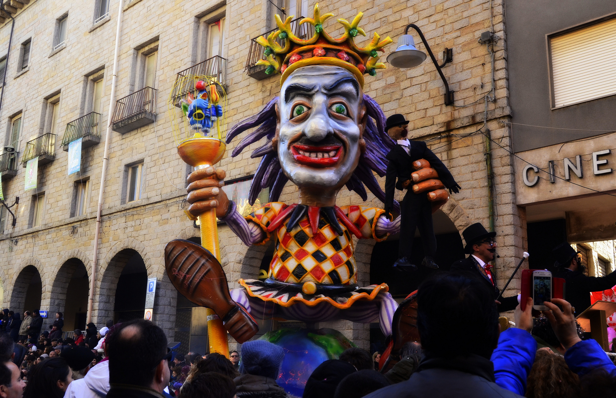
This is the "city of stone" - a place to relax among parks, springs and the health-giving mountain air. In central Gallura, at the foot of Mount Limbara, Tempio Pausania is a large town of 14,000 inhabitants with a picturesque old town of granite buildings and paving, with tree-lined streets. The town has always been a reference point for the Gallura area, the bishop's seat and the location of the local court. Mentioned in the Giudicato period as Templo, it added the "second" name in 1879 with reference to the old diocesan seat of Phausania. The town is famous for working granite and cork, to which the cork machinery museum is dedicated, for its wines (vermentino, karana and moscato), and for lu carrasciali timpiesu, an allegorical carnival par excellence that attracts 100,000 visitors every year. The festival includes lu palu di la frisgiola, an equestrian tournament featuring a carnival pastry, and lu acciuleddu 'e meli. Li casgiatini are eaten at Easter, and papassini at Christmas. From the local cuisine, the dish of suppa cuata reigns supreme. The high point of Holy Week are the Via Crucis and lu Sgraamentu. In August, the patron saints of San Paolo and the Vergie di Buoncammino are celebrated.
The modern-day town hall and Piazza Gallura stand on the site of an old Capuchin convent: the square is overlooked by the 18th century home of the Marquis of Pes di Villamarina, now the seat of the Curia and the Templense Museum. Next to it is the Cathedral of San Pietro Apostolo, dating from the early 13th century, later expanded, renovated and reconsecrated in 1839. Opposite the cathedral's imposing grandeur stands the Oratorio del Rosario (13th to 14th century), which may have been built on the site of the temple of Castor and Pollux, built to protect the Roman soldiers in Milizzana. Gemellae, the "Roman Temple", is said to take its name from the Roman Gemini. The cathedral, oratory and 13th century church of Santa Croce form the main religious complex. In the centre, you can also admire the "Spanish-style" Nostra Signora del Pilar. The church of San Francesco and the convent of the minor observant friars are the island's earliest example of Renaissance architecture (1543-48). Other historical churches include the church of the Purgatorio (18th century), Sant'Antonio (1657) and San Giuseppe. The convent of Padri Scolopi was an influential college set up in 1665 that played an important part in promoting literacy, and is now a library. Civil architecture includes the Massidda, Sanguinetti and Ex me (1663, first a prison and later a market) buildings; the Carmine theatre; the railway station with its paintings by Giuseppe Biasi; and the medieval residence attributed to Nino Visconti, Judge of Gallura and a friend of Dante, mentioned in the 8th canto of his Purgatory. Piazza Faber is dedicated to Fabrizio De André, with an installation designed in collaboration with Renzo Piano. An event named Incontri is dedicated to the singer-songwriter, who lived in the Agnata farmholding for years. In mid-July, the international folklore convention is held: Tempio has an elegant and valuable traditional women's costume.
Mount Limbara acts as a backdrop to the Rinaggiu springs, known since Roman times for their health benefits, and the Parco delle Rimembranze park where each elm tree stands for a WW2 fallen soldier from Tempio. The first traces of human settlement are Neolithic, while the most common are nuraghic: the mountain village of Lu Finocchiu, Giants' Tombs and a dozen nuraghes remain, including Majori and Izzana, which is probably the largest in Gallura.