
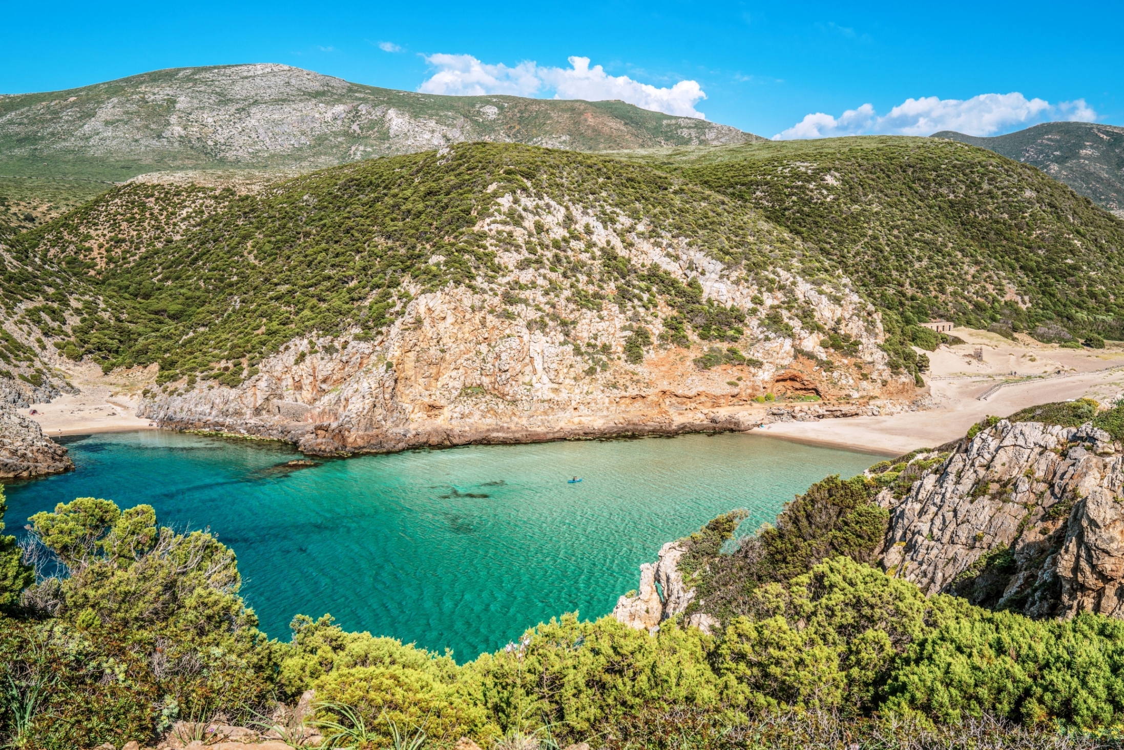
Cala Domestica
Up until 1940, minerals were mined and loaded onto ships here. Like an authentic open-air industrial museum, CalaDomestica, two kilometres south of Buggerru, still preserves the ruins of warehouses, deposits and tunnels dug by the miners. One of these to the right of the cala leads to a second, hidden, almost intimate cove known as La Caletta.
The larger cove is a deep and stunning inlet, almost a fjord, with a wide, sheltered beach with soft, compact sand that ranges from white to amber and gold. Small Mediterranean bushes dot the dunes behind the stretch of sand. In front, there is one of the most beautiful, turquoise and azure seas of Sardinia.
The impressive, white, calcareous cliffs that surround the beach make it feel like you're in a corner of paradise, where uncontaminated nature rules. The seabed is low and sandy, with a few rocks out to sea near the promontories. You won't hesitate to pull on a mask and dive in to admire the extraordinary submarine world, with a huge variety of fish swimming in the crystalline water. It is no coincidence that it is particularly popular with underwater fishing enthusiasts. CalaDomestica has a large car-park, camper van area, picnic area, access boardwalk and campsite. It is overlooked by a 18th century Spanish tower about 10 metres high, from which you can admire an unequalled panorama: climb up to the promontory on the left of the coast by following the path leading up from the beach. The tower was used in the 20th century as a second war's watchtower.
You'll be fascinated by several stretches of the surrounding coastline: to the right of the modern tourist port near the town centre, you'll find Buggerru beach, with its find, soft sand opening onto a limpid, azure sea (which has received awards from Legambiente and the Touring Club). The town is built on an old mining village, dating to 1864, overlooked by the exit of the Galleria Henry, a modern-day tourist attraction that once had a steam train running through it to carry the minerals extracted. To the north of the town you'll find the sandy dunes of San Nicolao, behind which is a dense pine wood, the perfect place for a mountain bike excursion.
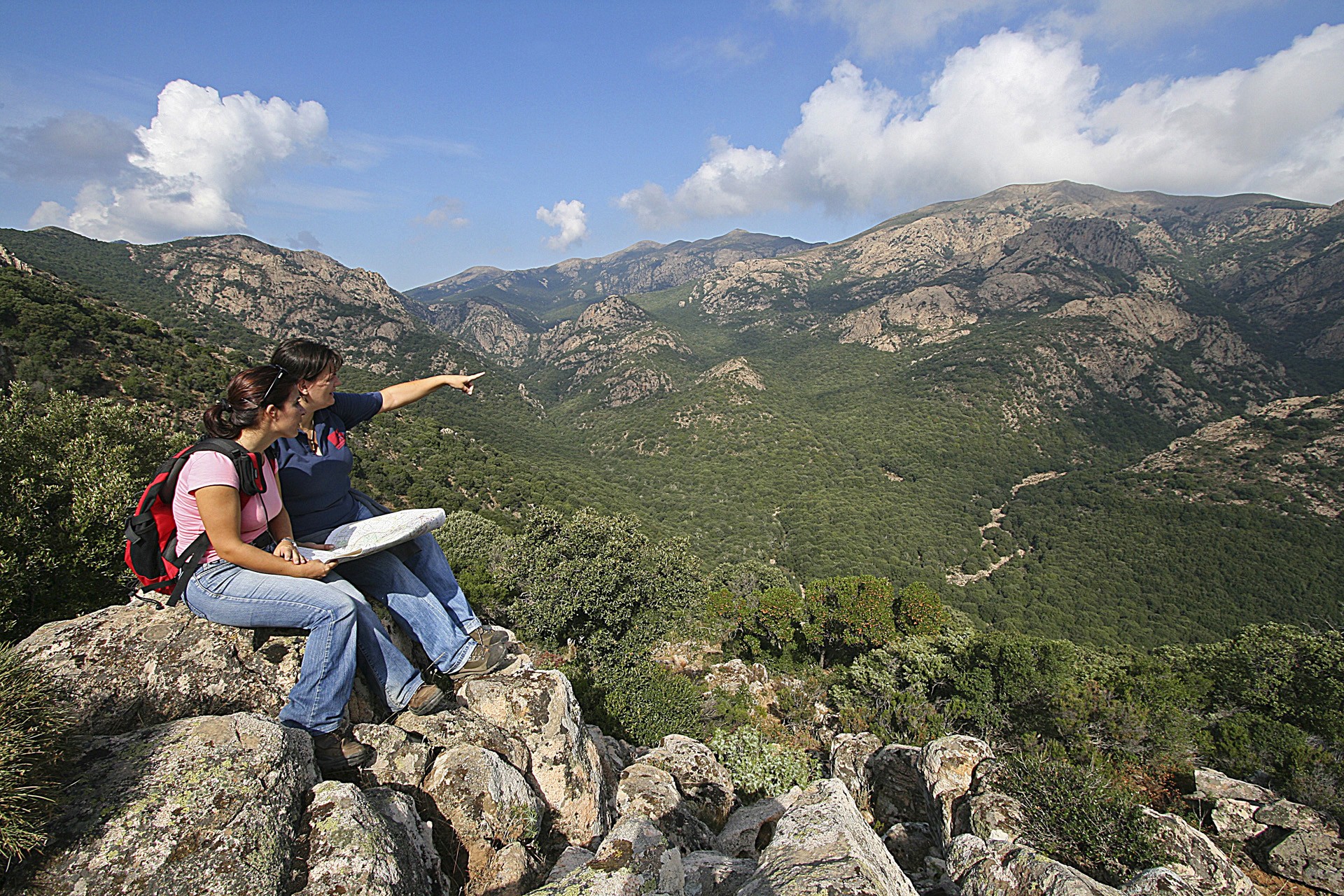
Monte Linas
An alpine landscape with wild peaks, deep gorges and sloping walls. Monte Linas is made up of granite rocks dating back 300 million years and is one of the most ancient landmasses to have emerged in Europe. It is located on the eastern border of the Iglesiente area, downstream of the Cixerri river, and it borders with the mountains of Arcuentu, to the north, and Marganai, to the south, to which it is connected by the Oridda plateau. It occupies nearly one thousand square kilometres in the territories of nine municipalities in the Medio Campidano area.
With its pink and grey granite peaks, it has almost eight thousand hectares of woodlands, made up mostly of holm oak forests. Thyme and helichrysum bushes fill the air with their fragrance, popping up between Mediterranean shrubs like strawberry trees, heather and phillyrea. At lower altitudes, you will find mastics, broom, wild olive trees and, near bodies of water, oleanders and willows. The lush vegetation is a home to several Sardinian red deer as well as wild boar, weasels, martens and foxes. If you look up, you might be surprised to see, flying overhead, the golden eagle, the peregrine falcon and the Eurasian sparrowhawk, which nest on the highest aiguilles, and the beautiful colours of the buzzard, the jay and the hoopoe.
A network of paths lead into the woods: you can enjoy trips on foot, by mountain bike and on horseback. The complex has various gorges and gullies with torrents that descend downwards and create spectacular waterfalls: you will be charmed by Sa Spendula, Piscina Irgas and Muru Mannu, which falls from a height of over 70 metres and is the highest waterfall in Sardinia. The mountainous landscape is located in a metalliferous area, which has been widely exploited. All around, there are the ruins of mining plants: Montevecchio, Ingurtosu and Perd'e Pibera, where there is a park. From here, by following the signposted trails, you will get to the highest point: Perda de sa Mesa (1236 metres). On the summit you can enjoy breathtaking scenery. A park named after the writer, Giuseppe Dessì, occupies the westernmost part of Linas, while in the limestone areas, towards Marganai, underground rivers flow and have created long underground caves over time, among which the beautiful cave of San Giovanni is really worth seeing.

Monte Arci Regional Natural Park
The largest source of obsidian in Sardinia, hidden in the bowels of a volcanic mountain. The green cloak of the Monte Arci massif rears out of the Uras plains, to the far north-east of Campidano, covered by basaltic lava flows that reveal its origins and history over the millennia. The volcanic chimneys culminate in its peaks: the 812 metre high Trebina Longa, 795 metre Trebina Lada and 463 metre Corongiu de Sizoa. Three peaks that bring to mind a tripod.
The area of the Acri regional park (270 squarekilometres) includesland from elevenmunicipalities in the Oristano area - Ales, Marrubiu, Masullas, Morgongiori, Palmas Arborea, Pau, Santa Giusta, Siris, Usellus, Villaurbana and Villaverde.
The obsidian, rarely found in the Mediterranean and ideal for making prehistoric weapons and tools, attracted ancient populations since the 6th millennium BC, who journeyed to Sardinia in order to stock up on the precious mineral. The deposits in PerdasUrias, s’Ennixedduand Su Forru de is Sintzurreddus (at Pau), Roja Cannas (at Masullas) and the Santa Luxia plateau (at Usellus) were points for collecting and working it. In Pau Museum, you can find out about the thousands of years of history created by obsidian. Contemporary sculptures made from huge, black blocks can be found around the town. Museum guides are available to take you on excursions to the quarries. General La Marmora stated that he had never seen such a large quantity of the black, shiny stone anywhere else. While you're in the park, also look out for the Brunk’es’Omu (at Villaverde) nuraghe and the Domu de is Coambus cave sanctuary (at Morgongiori).
Most of the area on the mountain is covered with holm oaks with occasional cork trees, downy oaks and Mediterranean brush. A splendid example of holm oak forest can be found at s'Acqua Frida in the territory of Ales, rich in springs. The woods are inhabited by wild boars, weasels, pine martens and foxes, while roe and fallow deer have been reintroduced. Overhead, you can spot wood-pigeons, finches, jays and hoopoes, while birds of prey nesting here include goshawks, sparrowhawks, lesser kestrels and peregrine falcons.
Aidomaggiore
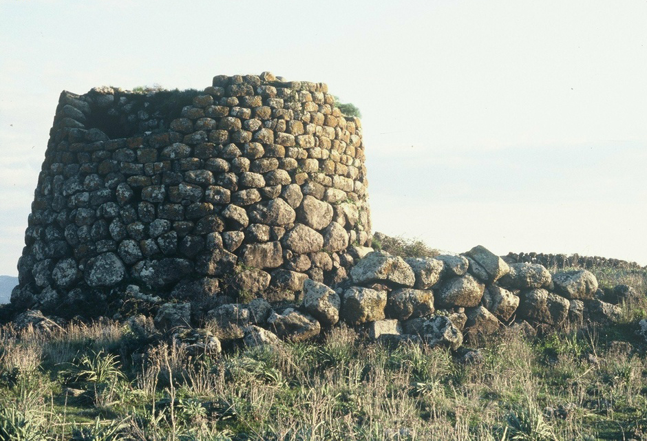
An ancient farming and shepherding village sits at the top of the high plain of Abbasanta, nestled in verdant woods of cork trees, olive groves, vineyards and fruit orchards with a view over one of the greatest artificial lakes in all of Europe, Omodeo lake, today a tourist attraction. Aidomaggiore is the preferred destination of nature and archaeology enthusiasts, of those who want to explore the lake in a canoe and see the sites that dot the territory, like the stone domus de Janas, the giant tombs, the Sanilo and sa Jua nuraghe and the largest, the Tosingalo nuraghe. Nestled in Mediterranean brush it is a single-tower building that stands out for the black basaltic stone with which it was made. The inner chamber has a terrace at a height of eight metres reached by a ramp of stairs.
Speaking of culture, there are also two spectacular country churches. Santa Greca dates to 1797 and is five kilometres out of town on a lovely hill not far from Omodeo Lake. It was on the same spot where an older church had once stood (Santa Giusta), which in turn had been built on the ancient grounds of a Roman camp that had been occupied until the late Imperial Age. The perimeter is dotted with settlements, some prehistoric, and not far away you’ll find other nuraghes (Atos, Mura e Logu, Uras). What is now the Church of Santa Maria delle Grazie (or de Orraccu), dates to the XVII century, but it has far older origins. On 8 September every year they celebrate with traditional dances, music and shows performed by folk groups from all over Sardinia. The celebration ends when the procession brings the statue of Maria Bambina to the Church of Santa Maria delle Palme, in the centre of town. The lovely location of the church offers beautiful views of Omodeo Lake, the Barbagia and Mandrolisai mountains. It was a strategic location, known as sa Bastia. Speaking of festivities and traditions, Aidomaggiore is also famous for its bonfires in celebration of Sant’Antonio, for its Carnival and, above all, for the rituals and festivities surrounding Holy Week.

Sa Jara Manna - Giara di Gesturi
An island within the Island, a magical place with unique characteristics. The Giara is a basalt plateau on the border between the Marmilla and Sarcidano regions: it rises abruptly to an altitude of 550 metres, dominating the surrounding flat landscape, rippled only by ‘gentle’, fertile hills. On the top, there is a twelve-kilometre long and slightly sloping ecosystem where rare animals and plants are preserved. To differentiate it from the nearby ‘smaller’ Giara plateaus of Serri and Siddi, it is called Jara manna (large), or Giara di Gesturi, a Municipality containing approximately half of its entire area (45 square kilometres). The other half is divided between Genoni (1600 hectares), Tuili (450) and Setzu (250). Its area also involves Albagiara, Assolo, Genuri, Gonnosnò, Nuragus, Senis and Sini. Each one has nature, archaeological and artistic sites and ethnographic museums, covered by a network of itineraries that can be enjoyed on foot, by bike or on horseback.
‘Giara’ may have evolved from glarea, or ‘ghiaia’ in Italian (meaning gravel), indicating the stoniness of the ground. Its origin comes from lava flows during eruptions that took place 2.7 million years ago on a sandy bedrock from two craters that are now extinct: Zepparedda, summit of the plateau (609 metres), and Zeppara Manna, the most scenic point. It was not the plateau that rose up but the surrounding lands that were lowered, as they were not protected by effusive rock and were eroded by water and wind. Sa Roja lies between the two volcanic cones and is a fault that runs across the plateau with a step of 30 metres. The steep sides have been ‘affected’ by landslides generated by torrents that arise at the springs of the plateau and descend along the edges. This is the origin of is scalas, access routes to the plateau, of which you will discover the geological history in the Geo-paleosite of Duidduru, and in the Paleo Archaeo Centre di Genoni. The isolated location has maintained a plant and wildlife heritage that has disappeared elsewhere, thanks to which Giara has been a site of European Community interest since 1995. It is covered in lush woods, centuries-old species of cork oak, often ‘forced’ to grow slanted by the northwesterly ‘maestrale’ wind. Then there are holm oaks, downy oaks, strawberry trees, lentisk trees and myrtle. In spring, the plateau is filled with colours and scents: there are helichrysum, asphodels and cysts are in bloom, as well as expanses of cyclamen and orchids and a yellow cloak of morisia, an endemic plant that gives its name to the botanical garden in the park. The most spectacular places are is paulis, depressions where rainwater stagnates. There are dozens of them, mostly modest and of short duration. In some cases, they are quite big and they last throughout the year, as with the two named pauli maiori. In springtime, the ponds are covered with a white cloak of buttercups, while in summer they dry up and look like ‘lunar’ expanses. The autumn rains colour them with the dark red of the tamarisk trees and a thin layer of ice often covers them in winter. They are the habitat of a rich microfauna, including two tiny crustaceans, ‘living fossils’ unchanged for millions of years. They are also the home of the western marsh harrier, the black-winged stilt and the mallard. The plateau is famous for its small horses, a unique case of a wild horse colony in Europe. Is cuaddedus gallop in small groups between the bushes, take shelter in the shade of the cork oak woods, drink in the pauli and are greedy for buttercups. Their origin is lost somewhere between legend and history. In the Middle Ages, entire herds populated the island and gradually disappeared. Today, about 700 of them graze in the wild on the Giara plateau: they have a thick mane, a long tail and a slender build, giving them surprising grace despite their size and wild nature. Completing the wildlife, there are wild boar, weasels, hares, martens, foxes and 60 species of bird, including various birds of prey.
The Giara is an unassailable natural fortress, with escarpment walls similar to bastions. A long bulwark against invaders, today it contains traces of a very distant past. A system of nuraghi presided over is scalas: there are 24 of them on the summit, mostly of the single tower type; the double ones and those with two or more towers were lined up at the foot and on the slopes. On the southeastern edge stands the Bruncu Madugui, the most impressive Sardinian protonuraghe with the remains of huts grouped in blocks. Some complexes were also frequented during the Punic-Roman era: Pranu Omus in Genoni, Santa Luisa in Tuili and San Lussorio in Albagiara; others arise next to springs: such as the nuraghe Scab’i Ois, near the spring of the park of Cracchera. The Giara is crossed by the longest stretch of paved Roman road on the Island: seven kilometres! In the Middle Ages only shepherds were already frequenting the plateau: evidence of this is le pinnettas, shelters similar to Nuragic huts.

Pan di Zucchero and sea stacks of Masua
Admiring the impressive rock at sunset, as it rises out of the sea just a few metres from the coast, increases its splendour: the sunlight bounces off the limestone silhouette in every shade of yellow and orange. Pan di Zucchero (meaning Sugarloaf) is one of the most impressive and spectacular natural monuments on the Island and the symbol of the coast of Iglesias. The name comes from its resemblance to the famous Pão de Açúcar (Sugarloaf Mountain) in the bay of Rio de Janeiro and in the 18th century, this name had already replaced the original Sardinian name Concali su Terràinu. You can get to it in a dinghy or by boat from the magnificent cove of Masua, a coastal district in the Iglesias area, just two and a half kilometres away.
Once having succeeded in reaching its rocky walls, which is not so simple, climbing enthusiasts, with equipment and supported by expert guides, can climb up its 133 metres: it is the highest sea stack in the Mediterranean. From the top, you will be able to see its three ‘younger brothers’ next to it, two of which are known as s'Agusteri and il Morto, the southernmost one. The four sea stacks of Masua are structurally homogeneous, connected and an integral part of the monument: their cerulean-white colour stands out against the violet-coloured coast in front of them. They are composed of Cambrian limestone, which is chemically almost pure, and they were formed by the erosion of the sea, which generated their detachment from the mainland and specifically from the cliff of Punta is Cicalas: the 300-metre stretch of sea separating them is often inaccessible.
Pan di Zucchero has a massive, rounded shape. Karst phenomena have pierced its surface (less than four hectares) with flat steps, leading to the creation of two tunnel-like caves. They open up at sea level, are 25 and 20 metres long respectively, and are both habitats for seabirds. It is possible to pass through one of them in a small boat. Opposite the little island, the outlet of the Porto Flavia mining tunnel looks out to sea, magically suspended halfway up the sheer rock face. It is the most visible extremity of a futuristic complex of underground tunnels that end at a construction carved into the cliff at the beginning of the 20th century. From here, the minerals were loaded directly onto merchant vessels. At the foot of mine, there is the cave of Grotto del Soffione, so called because of the effect of the waves that enter the cavity and ‘bounce’, making big splashes. Alongside the ruins, there is the little beach of Porto Flavia mine: from the small lido, a destination for scuba diving enthusiasts, you will be dazzled by the contrast of colour between the greyish-white of the giant marine limestone rock, the azure and blue of the sea and the green of the surrounding pine forest.
The entire coast of Iglesias has a wild appeal and a great variety of landscapes. Not to be missed, are Porto Paglia and Nebida, another small ‘mining’ district. Two kilometres to the north of is Cicalas is the Grand Canal of Nebida: it is a long, narrow valley, crossed by a torrent that flows to the sea in a splendid ‘fjord-like’ inlet, characterized by a small beach and a series of caves: at the foot of the cliff there is the Grotta di Canal Grande, a 150-metre long tunnel carved by the sea that crosses the promontory from one side to the other, just above the surface of the water; under the north wall, the Grotta delle Spigole (cave of the sea bass) opens up. Further north, there are the inlets of Porto Sciusciau and the beautiful Cala Domestica, in the territory of Buggerru. You can also visit the Grand Canal via land, departing from Masua: a trekking trail along the tracks of the mining works. The coastline and, more generally, the life of the Iglesias area were deeply marked by mining activities. At the end of the 19th century, a great deal mining work took place at the Masua mine, while today the complex includes dwellings located on various levels, a school, a hospital, a church and workshops. It is a ghost village and a stage of the Santa Barbara mining route as well as being part of the Geomining Park of Sardinia, recognized as a UNESCO world heritage site.
Antiquarium Arborense
Representing the history of the city and territory of Oristano, it safeguards a precious heritage. The Antiquarium Arborense museum was founded in 1938 as the third museum in Sardinia, thanks to the Oristano municipality’s acquisition of the collection owned by Efisio Pischedda, a lawyer who, combining forensic activities with a passion for archaeology, pieced together the largest private collection on the island in the 19th century, composed of finds from Tharros and the Sinis peninsula.
Renovated in 2016 and equipped with a multi-touch table and wall plus interactive 3D models, the museum conserves a legacy consisting of some ten thousand cultural and archaeological assets, consisting not only of the Pischedda collection, but also of those of Carta, Sanna Delogu, Pau, Cominacini-Boy and D’Urso-Vitiello. The exhibition is housed in the elegant and neoclassical Palazzo Parpaglia, which has housed the Antiquarium since 1992, named after its first curator, Giuseppe Pau. The finds, which cover a chronological arc from prehistory to the Middle Ages, are flanked by two reconstructive models, the Tharros of late Roman times (4th century AD) and Oristano in the era of the Judicatures (14th century), when the capital of the Giudicato of Arborea was the protagonist of the island’s history.
At the time the city, current capital of the province of the same name, was embellished with palaces, churches and fortifications, all surrounded by walls, of which considerable traces remain to this day, along with the majestic Torre di Mariano (or di San Cristoforo). After visiting the Antiquarium, to learn more about the Giudici of Arborea, the cultural tour can be continued with a visit to the Museo della Sardegna Giudicale in the baroque Palazzo Arcais.
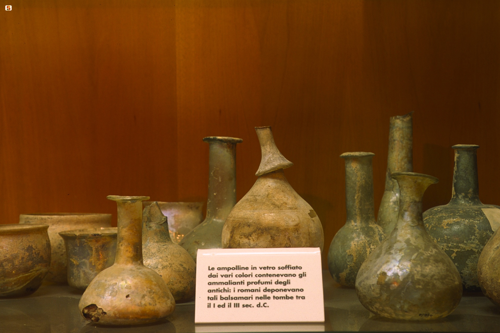
The ‘Parpaglia’ contains archaeological and ‘dei retabli’ (altarpiece) rooms, temporary exhibitions and the tactile museum exhibiting reproductions of artefacts from various cultural periods, which children and the visually impaired can ‘read’ with their hands. The room dedicated to the ‘sands of time’ offers a glimpse, as quick as an hourglass, that goes from the settlements from the ancient Neolithic times, hallmarked by the obsidian of Monte Arci, to the anthropisation in the middle and recent Neolithic age in Sinis, in Montiferru, Barigadu and the upper Campidano area. Widely documented are the pre-Nuragic and Nuragic civilisations, as creators of monumental architecture, bronze statues and, in Mont’e Prama (in Sinis), colossal statues of limestone warriors - preserved in the archaeological museums of Cagliari and Cabras - as are their interactions with other Mediterranean civilisations. The ‘highlights’ from trade between the peoples include a goblet of Attic-Mycenaean origin depicting Hercules fighting the Cretan Bull, a Carthaginian perfume burner which also depicts Hercules with a lion skin and the richest collection of Etruscan ceramics found beyond Etruria. The Phoenician and Punic ages (7th-3rd centuries BC), when Othoca (Santa Giusta), Tharros and Neapolis were founded, are represented by splendid grave goods. From the Roman and early Middle Ages (2nd century BC – 7th century AD), characterised by the development and splendour of pre-existing cities and the birth of the Forum Traiani, Cornus and Uselis, the most valuable finds are a collection of glass vases. The ‘antiquarian family room’ is dedicated to the lawyer Pischedda and family and to the archaeologist predecessors. The ‘sala dei retabli’ (‘altarpiece room’) safeguards three splendid Sardinian-Iberian paintings: Il Retablo del Santo Cristo by Pietro Cavaro (1533), the Madonna dei Consiglieri (1565) and the precious San Martino of the Catalan school (early-15th century). Also to be admired are ‘copies’ of artworks from the cathedral of Santa Maria Assunta and the church of San Francesco.
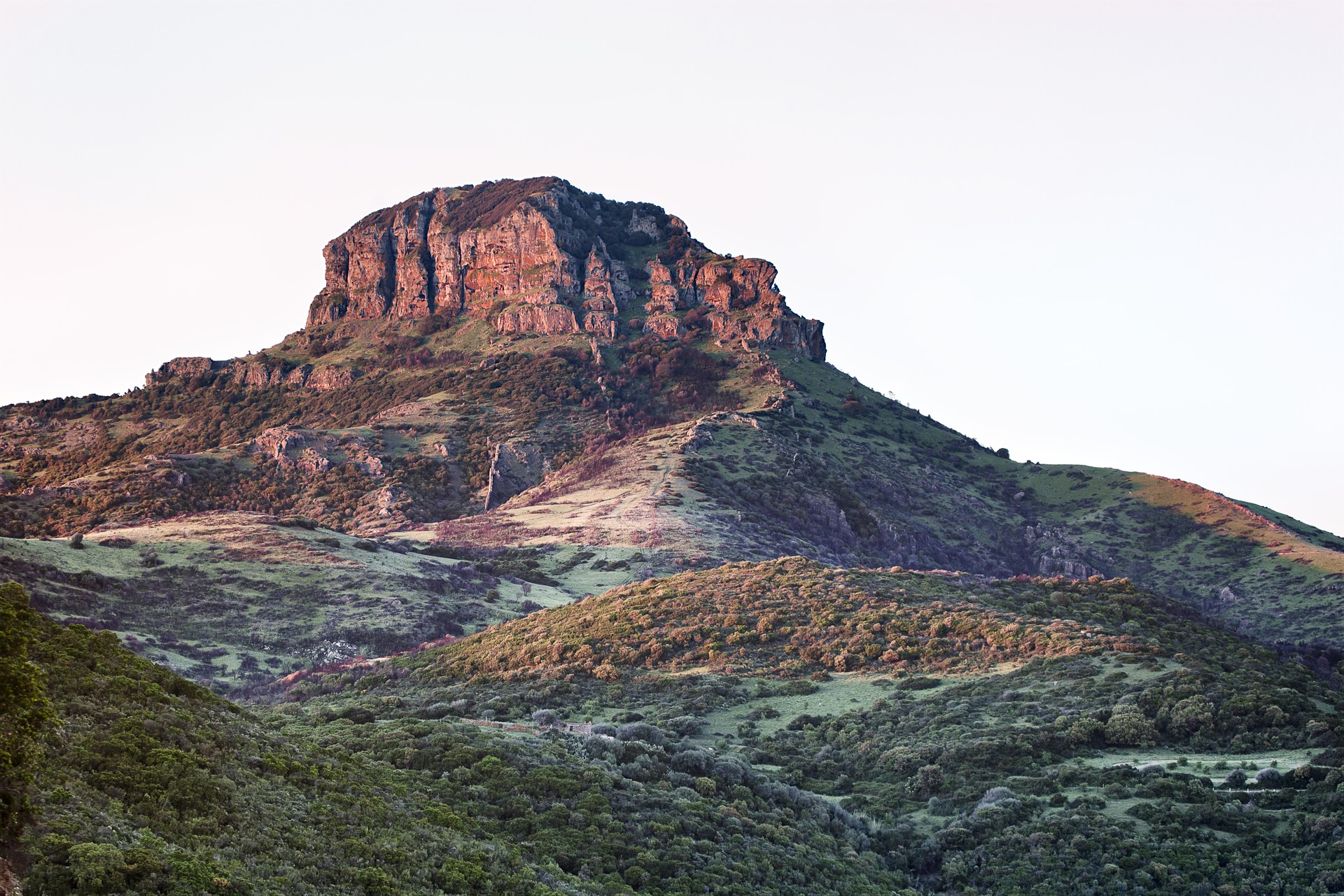
Monte Arcuentu
Arkù indicates the arched shape of the summit that, when seen from Piscinas and Scivu, looks like a dolomitic tower. The mighty Monte Arcuentu, a popular trekking destination, is part of a mountain range that runs parallel for eight kilometres to the beaches of the wild and wonderful Costa Verde. It is part of the territory of Arbus, which is eleven kilometres away, and it is near the Montevecchio mines, once the economic reference point of the area and today an open air museum of industrial archaeology. From the summit of Arcuentu, the horizon disappears before your eyes: you will admire landscapes of the nearby mountains of Arci and Linas, from the gulf of Oristano to the Costa Verde and from the valley of Campidano to the peaks of Montiferru, Sette Fratelli and Gennargentu.
The rocks - tuff and basalt of volcanic origin - alternate with aiguilles and towers as you climb. Along the slopes, there are flowing torrents that have created deep, narrow valleys. The Italian Alpine Club's (Club Alpino Italiano - CAI) easy trail leaves from the mines and will take you to the summit, at 785 metres, in a spectacular landscape. Along the trail, you will be walking through woods of holm oaks and Mediterranean scrub, from broom to orchids. The prayers and meditation of Fra' Nazareno and Fra' Lorenzo, of the 20th century, are linked to this place. Fra' Nazareno's hut is situated along the trail and Fra' Lorenzo spent a month here every year for thirty years. It is probable that, while walking, through the vegetation and rocks, you will see deer, wild boar, weasels, hares, martens and foxes. At the top, you will witness the flight of the golden eagle, the peregrine falcon, the buzzard and the Eurasian sparrowhawk, while in the background you will hear the song of chaffinches, robins and woodpeckers.
Punic oil lamps and a storage room containing coins were found in the mountain area, while a necropolis from the Roman period was discovered on the slopes. At the top, there is an ancient castle, which later became a monastery: you will see its ruins. The fortress, dating back to 1164 or earlier, was in a strategic position between the Giudicati of Arborea and Cagliari. It then became a monastery of the Vallombrosan order and flourished for three centuries before its decline and use as an arsenal. Some legends tell us about Arcuentu area: for example, there is the legend of Luxia Arrabiosa, the young woman from Guspini, whom a feudal lord wanted to marry. Lucia refused and he had her walled up alive in the mountain, along with a loom of gold. Today, shepherds say they can hear her singing as she weaves.
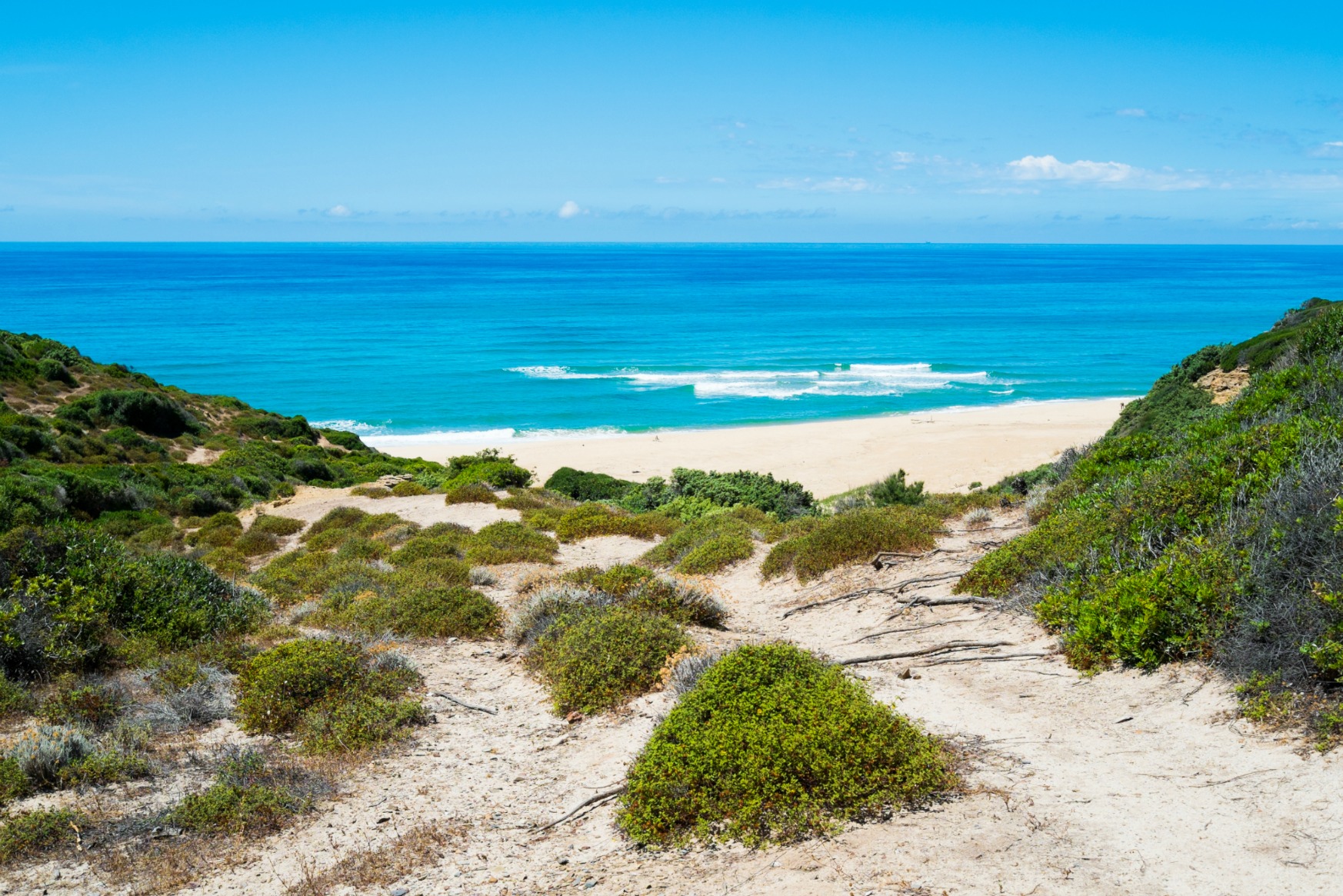
Scivu
It is one of the most beautiful stretches along the Costa Verde, in the territory of Arbus, a village in the province of Medio Campidano. It is not easy to get to, which makes it even more enchanting, and is located in a setting in which nature is almost completely unspoilt, with no villages nearby. In Scivu, you will witness a deafening silence, interrupted only by the surf of the sea and the cries of the seagulls.
The beach, with its pale, soft sand, which seems to 'speak' as a result of the echo you can hear when you walk on it, is divided in two by a small cliff and is a paradise for enthusiasts of underwater fishing. To the sides and behind it, there are reddish rocks and soft dunes, dotted with mastic, broom, strawberry trees and juniper, which descend from the mountains to the sea. You will reach it after travelling along a panoramic road, taking the paths between the dunes or going for a walk along the shore.
The water is astonishingly transparent and its colour is dazzling when it is lit by the sun's reflections. The most seductive moment is sunset, when the sand and the rock faces turn red. The seabed is varied: gullies, sandbanks and a scattering of rocks - everything that snorkelling enthusiasts are looking for.
The beach has ample parking, at the nearby beach of Nuraci, which is also suitable for camper vans, and there is also a place for dining/refreshments and equipment rentals. The wind is often strong and, not surprisingly, it is the ideal destination for surfers. However, caution is needed, because the Costa Verde sea is spectacular and wild, but rarely calm. Furthermore, it is one of the most well-known hot spots for surf-casting enthusiasts: almost all of the species of Mediterranean fish can be found here.
The dunes are a distinctive feature of the entire Costa Verde: don't miss your chance to visit the Sabbie d'Oro inPistis, the magnificent Torre dei Corsari, the beautiful Funtanazza, Marina di Arbus and Portu Maga, the ‘desert’ of sand in Piscinas that, along with Scivu, is the real jewel of this coastline, and lastly Capo Pecora, a much-loved destination for divers and fishermen.
Sa Mesa Longa
Set between the cliffs of Capo Mannu and the coast of su Pallosu, it owes its name to a natural sandstone barrier a few dozen metres from the shore that completely isolates it from the northwesterly “maestrale” waves, creating an authentic natural swimming pool. Sa Mesa Longa, ‘the long table’, one of the pearls of the marine area of the Sinis peninsula, is found in the locality of Putzu Idu, in the territory of San Vero Milis, twenty kilometres away: it is a beautiful, extremely long, varied and multicoloured beach, with ochre yellow soft, fine sand, a pinkish-red colour along the water’s edge made up of pebbles and shells and black rocks that cut the beach in two as it plunges into a sea that, depending on the light, reflects every shade of blue, with its shallow waters and sandy seabed.
In the middle of the bay and the huge natural pool, there is a small promontory that divides the beach into two parts, opposite the distinctive round-shaped islet, covered in vegetation, behind the dunes, while on the southern side, you can admire the cliffs of Capo Mannu. The unusual feature here is the natural ‘wall’, a few metres from the shore, which you can reach by swimming or, when there is low tide, by walking across flat rocks: when you climb up onto a rock emerging from the sea and you will feel as if you are walking on the water. Not surprisingly, sa Mesa Longa, with its exceptionally calm waters, is also called the Lagoon, a captivating and wild lagoon, greatly loved by surfers. There is ample parking at the beach, also accessible to camper vans, and a refreshment area.
To the north of the ‘table’ are the beach and the cat colony of su Pallosu and, beyond Capo Mannu, sa Rocca Tunda and the little coves of Scal’e Sali. To the south, at the base of the cliffs of the Capo, you will find the beaches of Mandriola, Putzu Idu and the splendid s’Arena Scoada.