

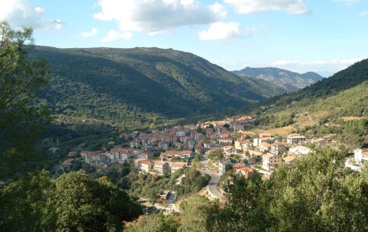
Orgosolo
A cradle of archaic traditions, Orgosolo reveals a deep bond with its roots: it is the land of the Canto a Tenore (Polyphonic folk singing), proclaimed a UNESCO World Heritage Site. Inhabited since prehistoric times, as can be seen by the domus de Janas, tombs of the giants and the Su Calavriche, Mereu and Gorropu Nuraghi, at the end of the 19th century, the village became known for banditry. Film director Vittorio De Seta, in the film entitledBanditi a Orgosolo (Bandits of Orgosolo - 1961), describes the bitter fight to defend the lands confiscated by the State.
During the twentieth century a cultural ferment developed, Muralism, which is still active and the origin of which was a tool of protest. Little lanes and stone houses are enriched by beautiful paintings, which have made the village internationally famous. Many artists have contributed to the creation of a real outdoor museum: hundreds of murals colour the streets and tell the story of traditions, culture and deep dissent.
Supramonte di Orgosolo features breathtaking landscapes. One of the paths leaving from the village leads to the Su Suercone sinkhole: where the land has created a chasm 200 metres deep and 400 wide. One of the natural monuments is the Gorroppu canyon, a long stretch of which is accessible: with walls 450 metres high, it is one of deepest in Europe. A walk in the forest of Montes is a must, to visit the sospinnettos, ancient shepherds' huts.
The village is famous for Su lionzu, an elegant bandage that frames the faces of the women dressed in traditional costume. Rare silk threads are used for the warp - the silkworm is bred in this area - while saffron is used to colour the weft.
There are two important dates to remember: on the 15 August "Ferragosto" holiday, an unbridled horse race takes place through the centre of Sa Vardia 'e mes'Austu, while mid-October sees Autumn in Barbagia, when the restaurants and accommodation facilities focus on the flavour of sapurpuzza, meat cooked according to an ancient recipe.
Birori
The village is located at around 450 metres above sea-level, in the foothills of the Marghine mountains, in the northern part of the Abbasanta plateau. Birori is a small village of round 500 inhabitants, founded in the Middle Ages with the name Birore, and originally belonged to the Torres Giudicato before passing to the Arborea Giudicato, the Oristano Marchesato and under Aragonese dominion.
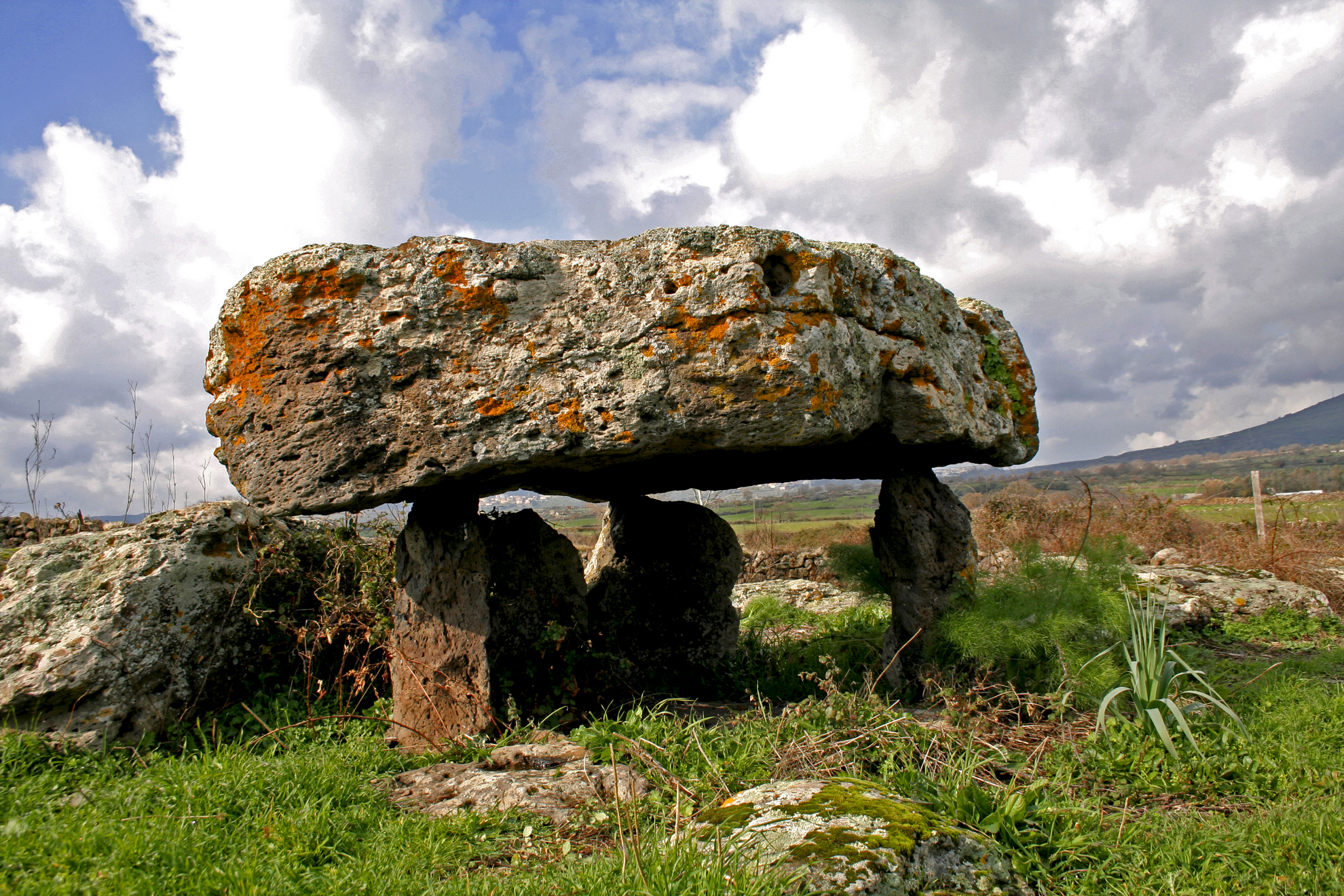
The area has been settled since prehistoric times, and has more than 50 archaeological sites and places of interest. The domus de Janas, menhir and dolmens at sas Bogadas and sa Perda e s’Altare date back to the Neolithic. Bronze Age holy wells, Nuraghes and Giants' tombs can also be found, including su Palatu in the village centre, and Lassia near the railway station, with two couples of niches raised off the floor, and perhaps used to place funerary offerings. On the edge of the village are the Arbu and Miuddu Nuraghes, the second with a central tower surrounded by a trilobed bastion.
The historical centre is laid out around the parish Church of Sant’Andrea, where the celebrations for Sant'Antonio take place in early August. The main square has a second religious building, the Church of Santo Stefano, which dates back to the 17th century. The village is surrounded by the green areas of Funtana Idda and Funtana maggiore, cloaked in woodland. In addition to archaeological sites and florid nature, Birori has a strong tradition of local cuisine: "turf" dishes such as broad beans with lard, pasta with dried tomatoes, boiled mutton, wild fennel soup, snails in sauce, lamb cordula with peas, wild boar in sauce, roast piglet or spit-roast lamb. Desserts include casadinas made with ricotta and cheese, sapa papassini, seadas, pirichittos and origliettas. The best time to taste them is in January, when the Fuochi di Sant’Antonio Abate bonfire is lit, or in June during the Primavera nel Marghine event.

Natural Oasis of Assai
A green lung made up of woods filled with holm and cork oak trees, interspersed with granite pinnacles, an area that once supplied coal to all of Sardinia and today preserves and protects indigenous vegetation and wildlife, as well as being home to an interesting museum. The Assai oasis extends for almost a thousand hectares between the territories of Neoneli and Nughedu Santa Vittoria. An ancient coal pit bears witness to the activity that thrived here, alongside the production of cork, until the 20th century. In 1983 the state forestry department took it over and Assai is now a permanent wildlife preservation zone. Today Sardinian deer, wild boar, fallow deer, wild cats and martens have made it their habitat. Among the birds, you may well spot some endemic Sardinian-Corsican species such as the sparrowhawk and the great spotted woodpecker, as well as rock thrush, raven and Sardinian partridge. For a few years now, even the golden eagle has returned to nest at the oasis.
You can also visit the wildlife museum housed in an ancient shelter once used by shepherds deep in the heart of the naturalistic reserve. The exhibition features stuffed specimens of the local fauna – mammals, birds and birds of prey – among which a golden eagle stands out set in a diorama that represents the forest. There is also a collection of minerals and fossils from all over the island. Outside, besides the coal pit, you can also visit a characteristic pinnettu.
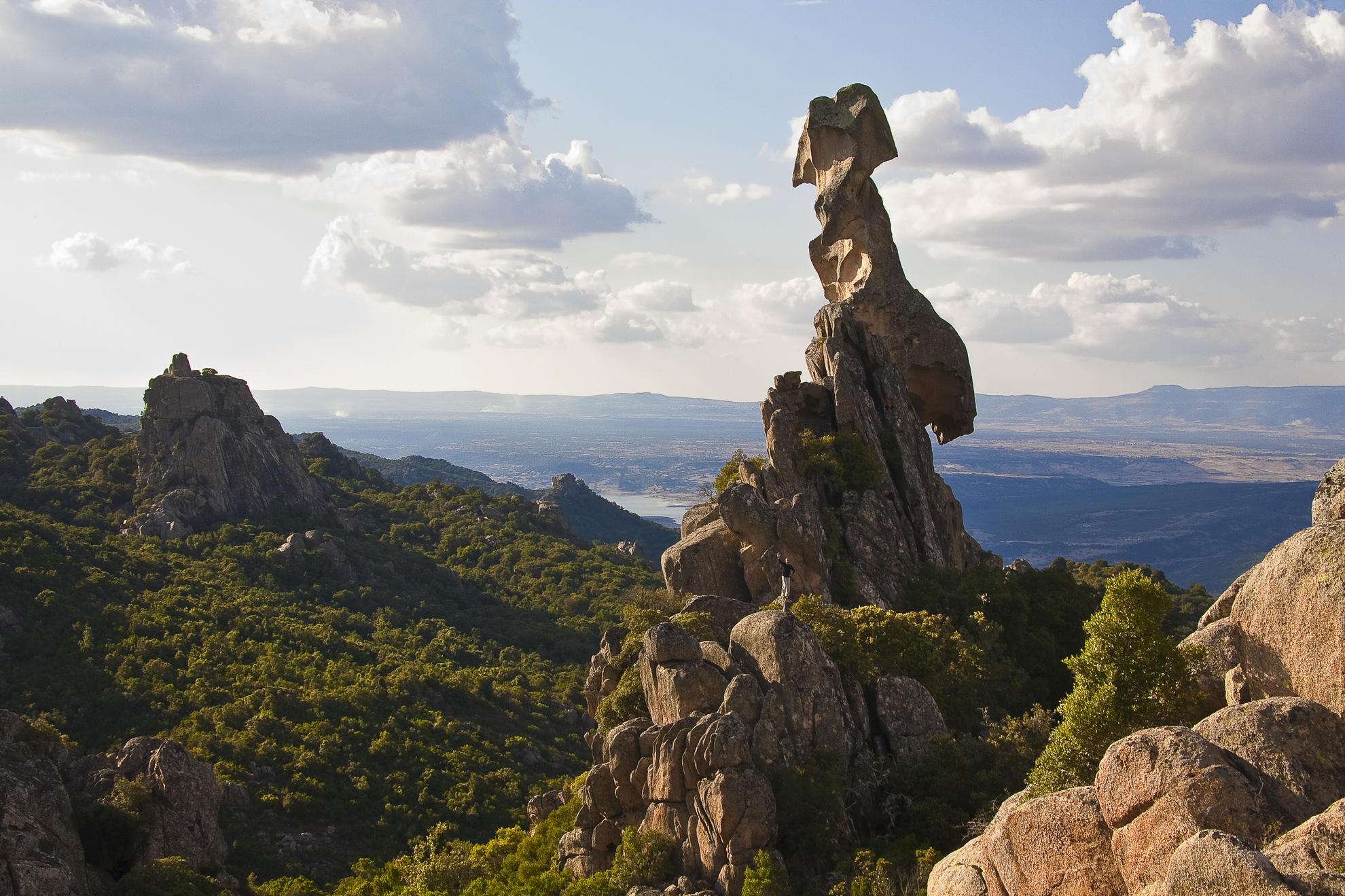
The vegetation here is also extraordinary: you will admire species typical of the Mediterranean brush, such as arbutus, ivy and lentisk, as well as flowers, in particular cyclamen, hawthorn, Spanish broom, lavender and wild orchids. The woods have paths you can follow either on foot, mountain bike or on horseback, with numerous panoramic points along the way to enjoy. One of the trails goes by the vista point of Borta Melone, at almost 900 meters above sea level, then by an artificial lake, finally leading to the natural monument of sa Crabarissa, a 50-metre-high granite rock whose shape resembles that of a woman in traditional Sardinian dress. An aura of legend surrounds her: the Crabarissa – meaning a woman from Cabras – was a girl engaged to a shepherd from Austis. When the shepherd left the town of Sinis to return to his own village, she stayed behind to wait for his return. When she became aware that days had gone by since she had heard from him, she went to Austis only to discover that he had married another. On her return home, the searing pain turned her to stone.
Austis
It is located at an altitude of over 700 metres on a granite plateau, surrounded by the mountains of Barbagia di Ollolai, covered by dense oak, cork oak and holm oak woods, and characterized by massive rocks sculpted by the weather, among which the two rocks of Sa Crabarissa, with a feminine appearance, and that of Sa Conca de su Cannizzu, shaped like an eagle. Austis is a little village with approximately 800 inhabitants, well-known for its agritourism facilities that will allow you to enjoy typical local dishes like sa fregula stufada, based on wheatmeal pasta baked in the oven. The breeding of sheep and goats it its main activity.
Beautiful granite houses distinguish the historical centre of the village. They are organized around the parish church of Beata Vergine Assunta, dating back to 1567 - as is confirmed by an inscription inside the building - in which there are various sculptures by Austis-born artist Elio Sanna, among which a crucifix, made from a single piece of wood from a wild pear tree. The most important religious celebration takes place in September, dedicated to St. Anthony of Padua. The church in his honour, built in 1669, is situated in the locality of Sa Sedda de Basiloccu, and inside it there is a precious Baroque altar.
The name Austis dates back to the Roman period and refers to the Latin base Augustis. The area in which the village is located was already inhabited in prehistoric times, as confirmed by the various nuraghi scattered around and dating back to the Bronze Age (beginning in 1700 BC). Subsequently, its territory was probably inhabited by the Nurensi tribes or the Celsitani tribes of the Gennargentu, that were in command of the Imperial army in the 2nd century AD. Austis emerged as a 'stazzo', a stopping place in the Roman-Augustan period, along the road that led from Karalis (Cagliari) to Olbia, passing through Forum Traiani (now Fordongianus).
San Mauro
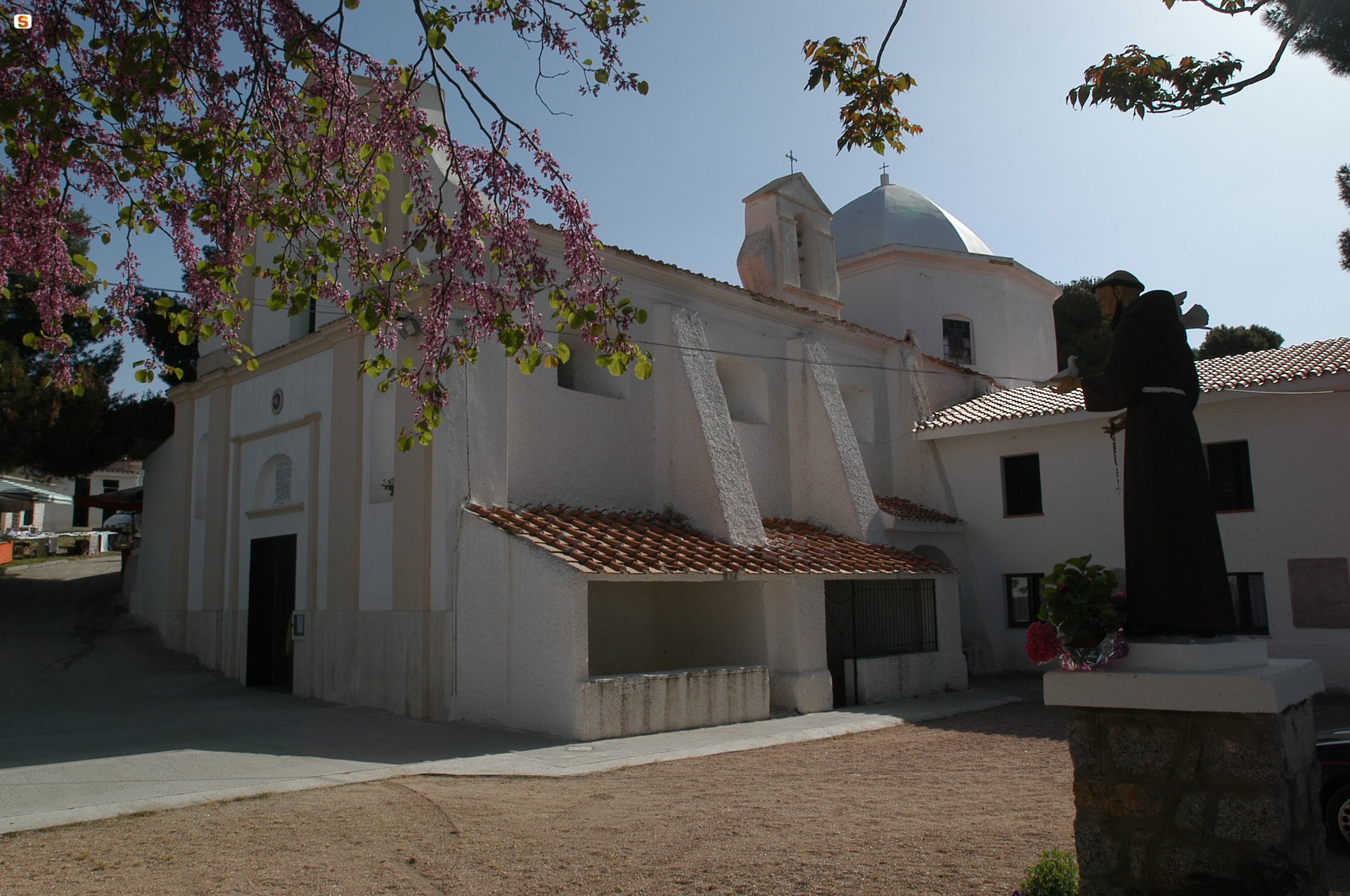
According to some historians the village came about in 1120, the work of Benedictine monks, while others believe it rose during the Aragonese period. The first mention of the lovely little church of San Mauro dates to 1574 and its history is impressed in every stone it is made of, including those of the muristenes and the nearby Nuragic monuments. It’s like a puzzle that give life to a commingling of historical periods that are well integrated amongst one another within a greater plan devised by the Catalan. The sanctuary rises on the steep slopes of Mount Lisai (a hill of just under 500 metres) in a lovely setting just five kilometres from Sorgono, one of the Mandrolisai’s most important towns in the very heart of the island. San Mauro is where Sorgono borders with Ortueri and Atzara.
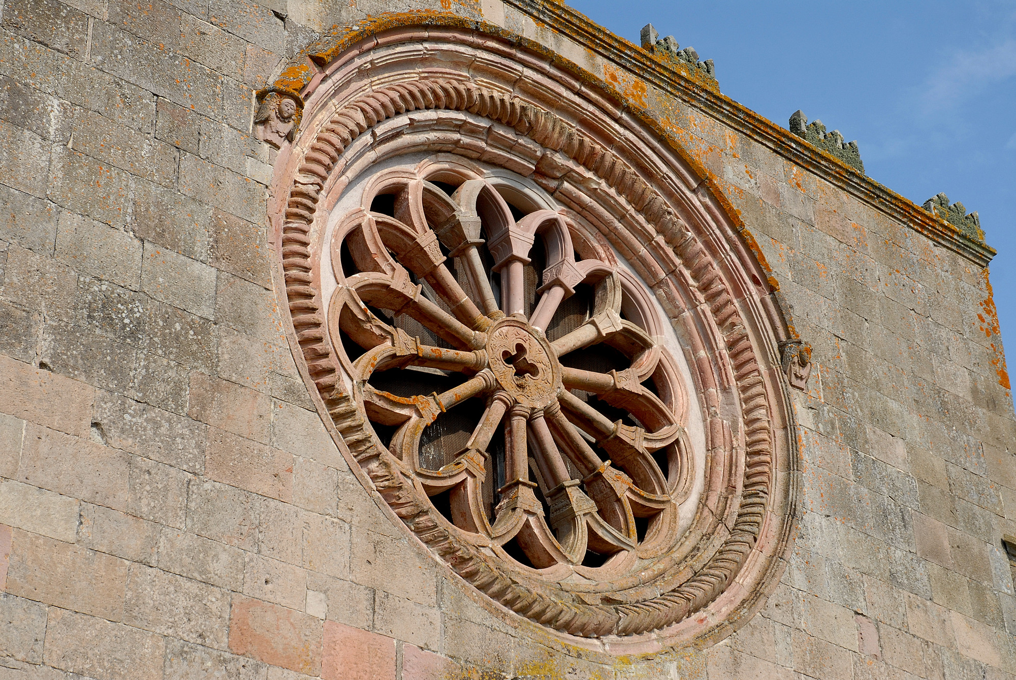
The building was designed by Giorgio Palearo Fratino, a military engineer who worked on public buildings and military fortifications in Sardinia under the Spanish king Philip II. The church is rectangular with a ten meter high and ten metre wide trachyte façade. The entrance is reached over a broad staircase with a lion holding up the Aragonese heraldic shield on either side, and the entrance is a great door done in the Late-Mannerist style. Inside you will notice that the ceiling is an oval barrel vault ceiling divided into six sections. The marble altar is Baroque and has a niche where a lovely wooden statue of the saint is housed. If you look up you’ll see the two-metre Romanesque rose window, the largest of its kind in the island.
The church is only one part of the sanctuary. The place of worship is part of a wider architectural complex that includes row houses, known as cumbessias or muristenes, built to accommodate pilgrims. In the past they were also used as loggias for vendors working the market set up during religious festivities. Still today pilgrims flock here by the thousands, especially on the last Sunday in May and in early June for the San Mauro celebrations, which also features a palio race, singing and dancing on the piazzas, stands selling fine local fare and exhibitions about the sanctuary and local traditions. On the outskirts of the Christian sanctuary is a stele from the nearby Funtana Morta Giant tomb, a gave linked to the Talei proto-nuraghe located just a few hundred metres from the church.

Bidonì
From a hill 260 metres above sea level the village overlooks the banks of Lake Omodeo, in the Marghine mountains, with a landscape that has few equals, ideal for trekking, mountain biking and canoeing, as well as a natural park and refuge for rare birds. Bidonì is one of the island's smallest villages, with just 150 inhabitants, and falls into the historical region of Barigadu. The earliest documents that mention the village where today's centre stands date back to 1157. Walking through the narrow streets is like going back in time: cobbled streets, medieval monuments and ancient homes in red trachyte stone, including sa ‘Omo ‘e sa majarza (the witch's house), which tells all about witchcraft and the Inquisition in Sardinia. Today, the traditionally agricultural hamlet is part of the Borghi autentici d’Italia circuit and the Domos Rujas comunità ospitale (tourism hosting organisation), together with the other "borgo autentico" Sorradile.
The most important part of its considerable archaeological heritage are the ruins of the Tempio di Giove, the only structure dedicated to the most important Roman god found in a rural setting on the island, and one of the three found in the whole of the Mediterranean. Built around 50 BC on the hill of s’Onnarìu, to the northern part of the village, the large structure takes up one side and the top of the hill. Two inscriptions dedicate the temple to Jupiter (Dei and Iovis), carved on the side of the altar. Several pottery fragments found inside date the occupation of the area to around the second or first century BC. The surrounding area was settled much earlier, as shown by the domus de Janas at Pera Pintore, the Bentosu Nuraghe and the remains of a Nuragic settlement now under the lake.
Two sanctuaries were built in the Middle Ages. The main one was the Church of San Pietro, from the 12th century, built in Romanesque style with squared stone blocks. The single nave has a gabled roof. Inside, it preserves a funerary inscription from the 9th century. In the countryside, there is the Novenario di Santa Maria di Ossolo, built in the 13th century but rebuilt in 1632, which is the location for one of the most popular celebrations held in early September: the procession runs from the rural church to the parish Church of San Giovanni Battista, the patron saint who is celebrated in late June. Another very popular celebration is on Easter Monday: the de s’anzone festival (lamb festival), when you can try traditional dishes in the setting of the Istei pine forest, near Omodeo, set up to host the numerous guests at the lunch. Agricultural products and simple yet finely flavoured food characterise Bidonì cuisine. The most typical dish is sos culurzones de patata (potato ravioli).

Nule
It climbs to an elevation of 700 metres along the south-western edge of the Buddusò plateau: from its scenic view point, you can enjoy a panorama that encompasses all of the Goceano, with its alternating elevations, including the lush Mount Tolidda, plains and valleys cut by the river Tirso, creeks and mineral springs. Nule is a Late Roman or Early Medieval town populated by 1400 inhabitants. Nule, at the centre of a long dispute during the age of the Giudicato, is now famed for its textile arts. It is one of Sardinia’s towns most known for the production of refined carpets patterned a framas, with thin, brightly coloured flames, woven on extremely old vertical frames using techniques passed down through the generations. The weaving together of weft and warp generates a dense fabric with a back and front that are identical but opposite. The “flamed” patterns originate from ancient rites, while more modern patterns were designed by Eugenio Tavolara. At the end of April, Nule is the scene of Idda ‘e Manos Bonas when craftsmen open their workshops in a sort of a “know-how” fair. Equally skilled hands prepare the pasta, bread, sweets and pecorino sheep milk cheese, a specialty of this town with a long herding tradition. Streets, homes and churches bear signs of a thousand-year history. Specifically, the 16th century former Parish of Santa Croce, which houses a wooden crucifix, and the Parish of Santa Maria Assunta. A Catalan Gothic church (1601) with two bell towers (one with an unusual cylindrical shape), housing a Baroque wooden altar and valuable paintings.
Nule’s surroundings are an open-air archaeological museum. First traces of human presence in the area date to early Palaeolithic (30-10,000 BC). There is evidence of numerous Neolithic settlements: in addition to fragments of ceramics and tools, there are dolmen and menhir. During the Bronze Age, the area was densely populated, as seen from 18 nuraghes and three Giant’s Tombs. Of particular note, the nuraghe complex of Istelai and the village of Santu Lesai, known for a bronze statuette of Nule, depicted having an animal body with a human head, found in the area. Housed at the National Archaeological Museum in Cagliari, it may be an ex voto of the water cult. The most majestic, significant and best-preserved monument of the area sits seven kilometres from the town: Nuraghe Voes, dated to 1200-1000 BC, a period when the Nuragic civilization was at its peak. A complex structure composed of a central tower originally two stories high surrounded by a three-lobed bastion enclosing a courtyard. The towers are linked by curtains similar to those of Nuraghe Santu Antine in Torralba. The walls are composed of carefully shaped granite masses of decreasing size. Various Imperial and Republican Rome copper and silver coins and a Punic-age pottery fragment were found here. It joins other Phoenician-Punic pieces - a type of funerary urns - found at other Nuragic sites (s’Agara, Isporo and Tolidda).
Lula
The town clings to the western slopes of the Mount Albo chain, among forests of holm oaks, yews, junipers and Mediterranean scrub, home to mouflons and royal eagles. Lula has a population of 1400 and lies 40 kilometres from Nuoro, with a long history running from the Neolithic to the recent past linked to the silver and lead mines of sos Enattos and Guzzurra-s’Arghentaria, today part of the Parco Geominerario della Sardegna. Mining activities here date back at least to Roman times, using slaves condemned to ad metalla work. Production peaked between the 19th and 20th centuries, slowly declining before being closed in the 1990s. Lula was the scene of one of the first miners' strikes (1899), which ended in tragedy. Today, you can see the tunnels, washery and machinery at sos Enattos. The people of Lula also produced charcoal, much in demand, and lime. The extraction sites are set in spectacular landscape, including the Albo mountain chain that dominates Baronìa with ravines, sinkholes, caves and peaks reaching over 1000 metres. The "Sardinian dolomites" have suggestive trekking itineraries to the sas Piperai canyon, Punta Caterina, the Janna di Murai pass and sa Tumba ‘e Nurai. "Lunar" landscapes emerge where the greenery becomes sparse. The cliffs offer dozens of opportunities for climbers. The mountain and territory of Lula have been inhabited since pre-Nuragic times, as witnessed by the important concas de Omines Agrestes and de Crapas, and the domu de Janas at Mannu ‘e Gruris. The most important Bronze Age remains are the Nuraghe at Littu Ertiches, built in limestone blocks, the village at Punta Casteddu, the "corridor" Nuraghe at Pretichinosu, the complex at Colovros, the s’Aliterraglia settlement and the remains of a water cult temple at Untana ‘e Deus.
The town churches include the parish Church of Santa Maria Assunta and two dedicated to the Madonna degli Angeli and the Madonna di Valverde (early 18th century). In the countryside, two kilometres from Lula, lies the most famous religious building: the Santuario di San Francesco d’Assisi, a popular pilgrimage site and home to two celebrations, at the beginning of May and early October (described by Grazia Deledda in ‘Elias Portolu’), for which a unique dish is also named, su filindeu. There are three festivals in September: Madonna del Miracolo, San Nicola and San Matteo, with meals based on boiled mutton and black pudding. Another long-running tradition is su Carrasecare luvulesu, one of the most interesting carnivals on the island. The leading role is played by the figure of su Battiledhu (‘the victim’), dressed in black leather, with an ash and blood-smudged face and a horned hat, held on by a women's scarf. The festival originates from ancient rites to fertilise the land with blood. The carnival is begun in mid-January by lighting the Fuochi di Sant’Antonio Abate bonfire, with singing, wine and typical pastries such as s'aranzada.
Tiana
It is located on the western slopes of the Gennargentu massif, at an altitude of 600 metres, near the geographical centre of the Island, surrounded by an evocative landscape with mountains over a thousand metres high. Tiana, a village with 500 inhabitants in the Barbagia di Ollolai region, is the village of orbace, a fabric obtained from spinning wool, famous since 206 BC and commonly used until the 20th century, while today it is used to make traditional winter clothes. The environment in Tiana is uncontaminated and its centuries of traditions, simple lifestyle, authentic agri-food products and sense of community contribute to a healthy and serene life: numerous long-living elderly people were born here: Antonio Todde, who was 112 years old in 2001, had been listed in the Guinness book of records as the oldest man in the world. Narrow streets, houses huddled together and corzos, passages covered by arches, the work of the maistos de muru, characterize the historical centre of the village, near which there is the eighteenth-century parish church of Sant'Elena Imperatore, celebrated in mid-August.
The village is set in the Tino valley, at the point in which it is crossed by the Rio Torrei. The two watercourses form an upside-down T flowing into the Taloro lake. The rivers were an economic resource. Between the 18th century and the first half of the 20th century, there were dozens of mills and fulling-mills on their banks. The museum of industrial archaeology Le vie dell'acqua (water routes) in the locality of Gusagu, bears witness to this and includes Sa Cracchera de tziu Bellu, the last active fulling-mill on the Island (one of very few in Europe). Inside it, a large mallet, put into action by the water, presses and fulls the orbace material, making it strong, waterproof and soft.
The outskirts of the village are thick with holm oak, downy oak, cork oak and chestnut tree forests. Not to be missed, are the lush slopes of Mungianeddu, the valley of Bau 'e Fonne and the woods of Sa Costa 'e Sili and Orovole. 85% of the municipal territory is covered in forests. Only Belvì and Seulo has similar percentages in Sardinia. To enter the woods, take the trails that were used during the transhumance of livestock in the past. The agricultural and pastoral tradition is also in the cuisine, with typical breads (pane fresa and pane carasau) and cakes for recurring events: sa panemanna for the Fuochi di Sant'Antonio Abate, pardulas for Easter and papassinos for All Saints' Day. When Autumn in Barbagia comes to Tiana, taste the 'fruttine', almond paste shaped like colourful fruits and sugar-coated. The lay festivity par excellence is the merculis de lessiu, the carnival celebrated on Ash Wednesday, during Lent (like in Ovodda), to mark its profane nature. Tiana has always been a border land, inhabited since prehistoric times, as confirmed by the Domus de Janas of Mancosu and the Nuragic ruins of sa Piraera and Tudulo. In the Roman era, the village was an outpost of Barbarism: here, the people of Barbagia and the Romans lived in contact.
Osidda
It sits at the north-western edge of the Bitti plateau, a short distance from the river Tirso, in an area where ancient trails through woods of cork oaks lead to breath-taking views and sites of great archaeological importance. With about 250 inhabitants, Osidda is the smallest municipality in the Province of Nuoro, wedged between two territories, Buddusò and Nule, and surrounded by vast green expanses that invite long walks. In the Medieval period, it was part of the curatorial of Monte Acuta in the Giudicato of Gallura. Today it is a agro-pastoral town with close ties to its unique traditions.
Its historical centre has retained fascinating architectural characteristics from the past: granite houses climb up narrow alleys paved with flagstones and overlooked by wrought iron balconies decorated with flowers that create scenic colour contrasts. Beam ceilings and rustic wood floors create warm and cosy environments. The imposing 19th century Palazzo Delogu, the town’s symbol, catches the eye. At the highest point in the town stands the Parish of Sant’Angelo, built in the 13th century. In May, the saint’s martyrdom and burial are celebrated, while laic festivities are held at the end of August. The city park is located a short distance from the church. On the main square, inside an old barrack, a miniature nativity scene with characters wearing traditional Sardinian outfits has been set up. In the town hall, you can visit an exhibition of historical photographs of the town.
The area surrounding Osidda has been inhabited since Pre-Nuragic times, as seen from the Punta Santu Paulu site to the north, where the town once stood. A few steps away, in the S’Impiccadolzu area, stands one of the tallest menhirs in Sardinia (over 7 meters in height): an imposing artefact immersed in greenery. The Bronze Age is represented by about fifteen nuraghes and various Giant’s Tombs. Some of the best preserved examples are S’Iscobalzu, with a five-meter-tall tower; the Piradolta complex (nuraghe and a Giant’s Tomb); Usanis nuraghe, perched on a granite mass and originally composed of two towers linked by a wall; and Merula, next to which a Well Temple once stood. The biggest site, however, is the village of Sa Contra e S’Eris, a charming and interesting Nuragic and post-Nuragic settlement. A short distance away but still in the Bitti territory, there is one of the most famous Nuragic sites of the island: the Romanzesu village/sanctuary.