

Sant'Andrea apostolo - Orani
One of the last examples of neoclassical architecture on the Island, consecrated in the first half of the 20th century, stands at the top of a monumental flight of steps, and includes sacred items, such as a spectacular altarpiece. La parish church of Orani, dedicated to Saint Andrew the Apostle, has the appearance of a Palladian-style temple. The building has a troubled history: designed to replace the ancient church dedicated to the same saint - now reduced to ruins, except for the bell tower which is still in good condition -, its construction site started up just 60 years after the abandonment of the previous parish church and, because of a dispute with the builders, it was completed many decades later, in 1930.
After going up the flight of steps, you can admire the gabled tetrastyle pronaos, supported by columns of the Tuscan order, before the façade. Inside, you will see a large, bright construction, with a Greek cross layout, in which, where the arms converge, and there is a semi-spherical dome with a lantern. There are pilasters and Ionic half-columns. Your attention will then be captured by the altarpiece, created by Orani-born artist Mario Delitala: the work depicts the Glory of Saint Andrew, surrounded by a triumph of angels. You will then see a 17th-century pulpit in inlaid marble, which came from the ancient parish church, a wooden pulpit originally located in the nearby Church of the Rosario and a retable dating back to the 16th century.
During the Spanish dominion of the Island, Orani was a populous and important centre and home to a marquisate. Its main place of worship was the Aragonese Church of Sant'Andrea. You can see what remains of it on the southern outskirts of the town. It also had a Greek cross layout, built using mixed stone and exposed volcanic rock in the jambs and architraves. In the relieving arch above the portal, you will notice an ashlar depicting Saint Andrew’s cross. Furthermore, traces of chapels with barrel and cross vaults can be identified. Unlike the church, the bell tower was renovated and so it is still intact. The tower, made of squared volcanic stone ashlars, is square-shaped and has six levels separated by cornices, rising up to the crocket spire.
Today, Orani is known for its archaeological heritage, for its enchanting hilly landscape, its artisan and agropastoral traditions and for being the birthplace of several artists: as well as Delitala, Costantino Nivola was also born here. You will be able to learn more about the internationally-renowned sculptor by visiting the Nivola Museum, which contains over 200 of his works.
Ottana
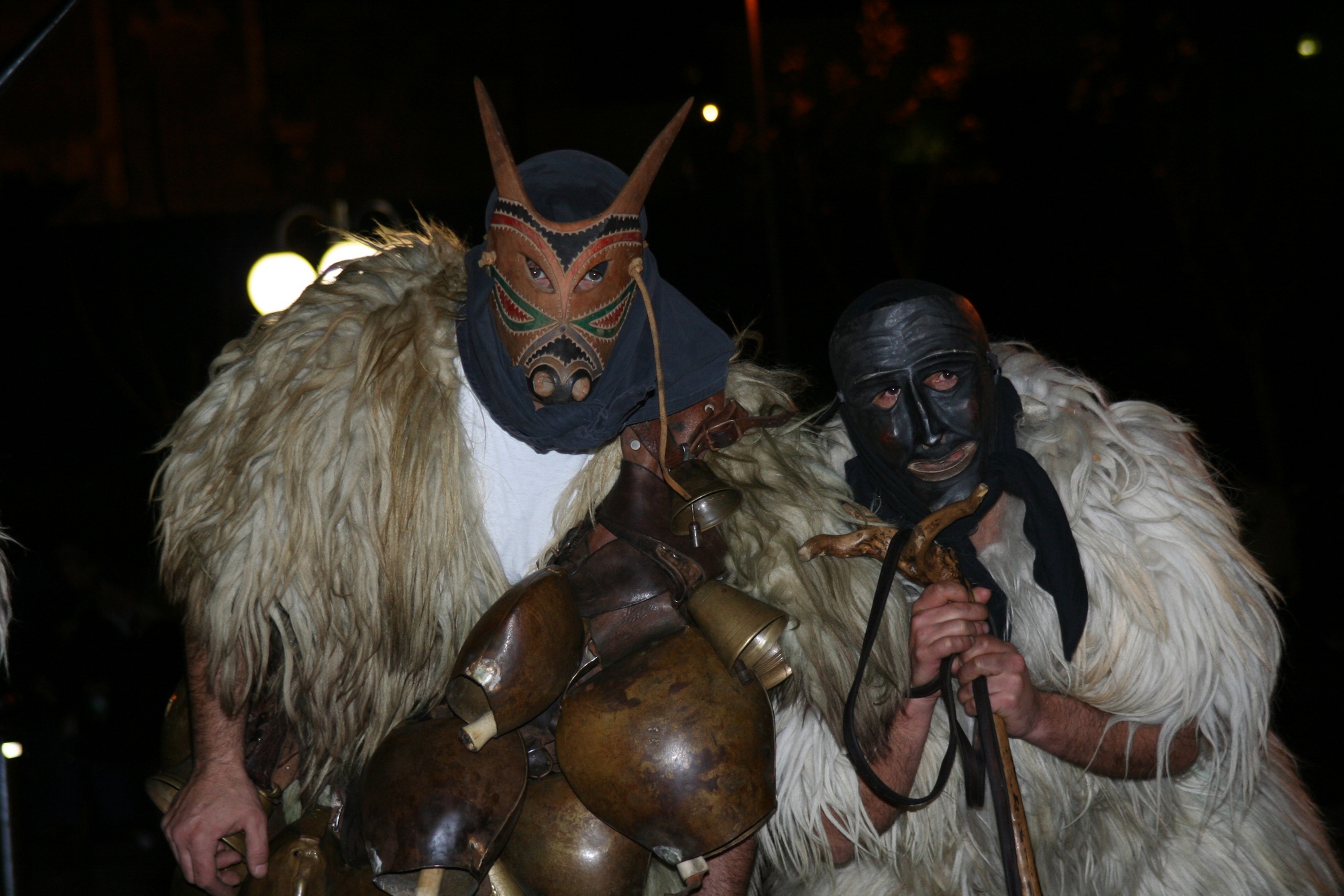
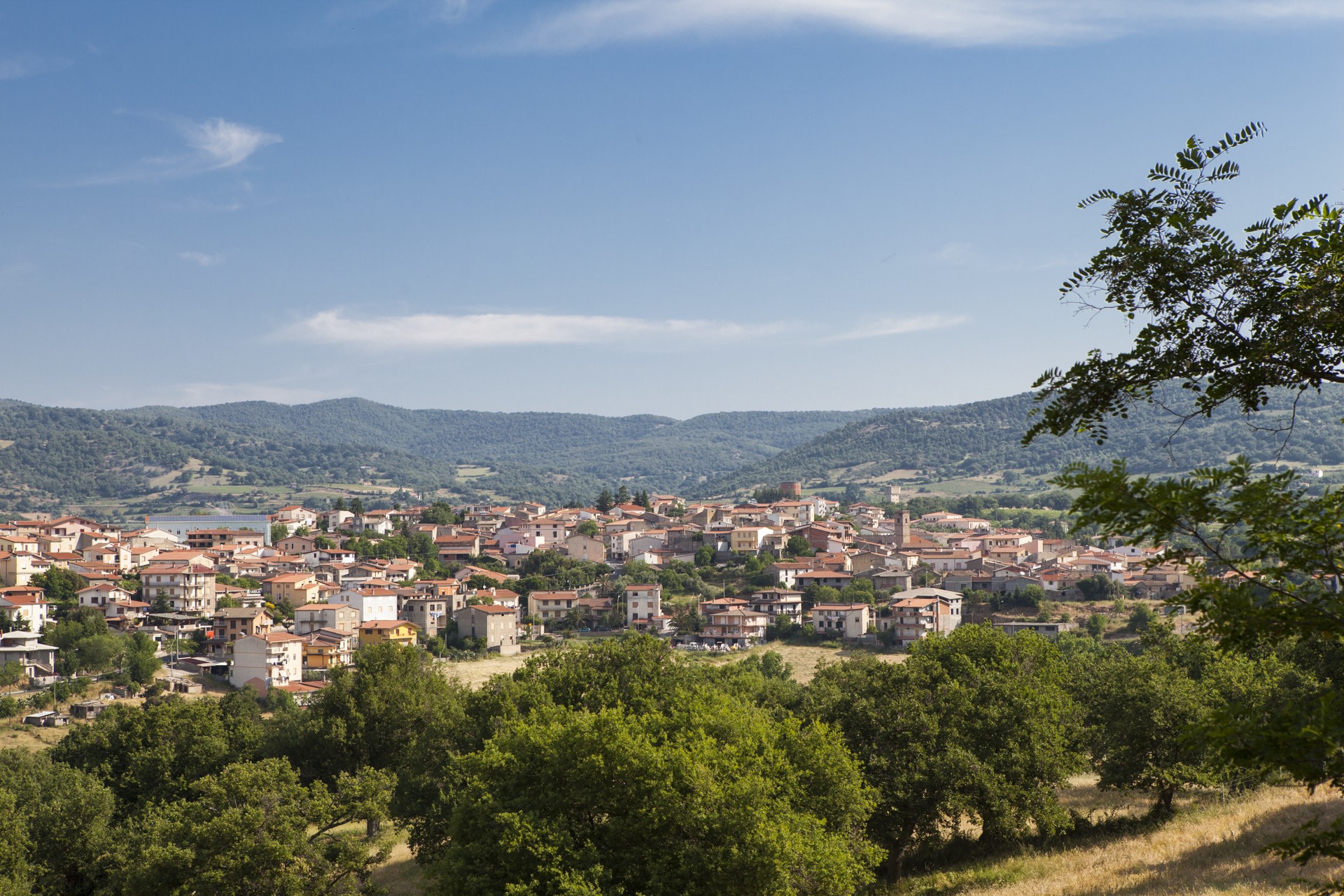
It was once an episcopal see, symbolized by the former cathedral, and today it is the village of Boes and Merdules, wooden monstrous-looking masks, protagonists of one of the Island's most famous carnivals. The village of Ottana was originally pastoral and, at the end of the 20th century, it became a site for the petrochemical and textile industries. Today, it is mainly dedicated to agricultural activities, artisan agri-foods and wood. It has two thousand 300 inhabitants and stands near the hills of Barbagia di Ollolai, on a large plain in the valley of the Tirso river, that forms lake Omodeo a little further south. Ottana has deeply-rooted traditions that have resisted over time, among which Su Carrasegare. The masks of Ottana retrace the archaic agricultural and pastoral rituals.
It is during the Fuochi di Sant'Antonio Abate (Fires of St Anthony) that the Merdules (hunters) and Boes (animals to capture) come out for the first time, in mid-January. The Holy Week rituals are deeply heartfelt and culminate with S'Iscravamentu, an engaging ceremony accompanied by the choir of sos tenores. The Assumption of Mary into heaven is celebrated on the 15 August Ferragosto holiday. Flavours are also linked to its origins. Among the breads, pane fresa stands out, while among the specialties, there are the sos cogones, filled turnovers cooked in the oven, and among the pastries, there is s'angule, a symbol of Ottana and originally made as an ex voto offering. You can taste it during Autumn in Barbagia and, at the end of May, during the celebrations in honour of Santu Nigola. One of the main religious monuments in Barbagia, the church of San Nicola is dedicated to the patron saint. The austere and charming Romanesque architecture, a cathedral from 1112 to 1503, dominates the historical centre with grandeur and alternates the two colours of the black-violet basalt and pink trachyte. Inside the high and 'austere' interior, there is the Pala di Ottana, a fourteenth-century polyptych by the Master of Franciscan tempera painting. Next to it, there is the fifteenth-century church of Santa Maria.
The village has very ancient roots, dating back to the Recent Neolithic period, which is demonstrated by the Domus de Janas necropolises of Sas Concas and Sorgosío, walls and megalithic structures, and to the Metal Age: there are about ten corridor nuraghi, some with tholos, approximately 15 single-tower and few complex ones, various villages of huts, dozens of tombs of Giants and the sacred well of Zuncos. The archaeological area of Bidinnannari is the main site, made up of 'mixed' nuraghe - two towers have been added to one corridor nuraghe - an inhabited settlement extending for 400 square metres and funerary buildings: a small dolmen, four tombs of Giants (one of which is well-preserved) and one allée couverte tomb. The complex of Talinos is also interesting, with single-tower tholos nuraghe and circular huts. The ruins of the thermal structures of Banzos also remain, dating back to the Roman age, when Ottana was a highly populated centre and one of strategic-military control for fighting the barbarians.
Atzara
The light and colours of its countryside, 'covered' with vineyards and orchards, and its rugs and traditional clothes inspired painters in the first half of the 20th century. Atzara is a delightful village of medieval origin in the Mandrolisai area, on the border of the provinces of Nuoro and Oristano, perhaps founded around the year one thousand. Tradition indicates that the first settlement was in the locality of Bigia 'e Josso, near a spring. The village is one of the five most beautiful Sardinian villages in Italy, has more than a thousand inhabitants and, today, it still preserves the urban fabric of the Catalan age, with low, granite architecture and oak beams covering the ceilings. The houses in the most ancient districts have chiselled decorations on the door and window frames. All around, there are woods and hills cultivated with vineyards, from which the famous 'black' wine (namely Mandrolisai) is obtained, to accompany the 'gems' of the confectionery tradition: is bucconettes and su gattou, made of almonds, and sa tumballa 'e latte. In May, the wine festival is a not-to-be-missed event.
The textile tradition is very refined, particularly the rugs and traditional costumes. Atzara is famous not only for the light and colours of its views and also the unusual female dress, with the distinctive hat (sa tiagiola), which became a protagonist in works of art by great painters in the first half of the twentieth century. The village has served as host to Spanish costumbristas Chicharro Agüera, Ortiz Echagüe and De Quirós, who were fascinated by its folk dress and traditions. Atzara became the centre in which a Spanish-inspired native pictorial language developed, as well as a destination in which important Sardinian artists would stay: Antonio Ballero, Giuseppe Biasi, Francisco Ciusa, Mario Delitala, Stanis Dessì, Filippo Figari, celebrated in the historical centre of the village by the museum of modern and contemporary art, named after Antonio Ortiz Echagüe, who created the most famous painting, ‘Women of Sardinia'. It is set up in a nineteenth-century building, organized into a historical room, with images of the village in the early twentieth century, an artistic room with works by foreign, Italian and Sardinian painters, and a part dedicated to temporary exhibitions.
In the historical centre of the village, the parish church of Sant'Antioco deserves a visit and is a worthy example of Catalan-Gothic architecture dating back to the end of the 15th century. Inside it, there are two wooden altars from the Baroque period, a statue of the Virgin Mary with child (end of the 16th century) and sixteenth-century silverware. It is the place in which the celebration of the patron saint takes place: in the past, on this occasion, strangers were offered su pane 'e sapa, another typical pastry. The Romanesque church of Santa Maria Bambina is perhaps the most ancient in a territory dotted with evidence of prehistoric times: Domus de Janas, tombs of Giants and nuraghi, among which Abba Gadda, which is very well-preserved.

Bruncu Madugui
Sa Jara manna, the Giara di Gesturi, is a special place under various aspects, first and foremost environmental and naturalistic, but also archaeological. The huge plateau, an unassailable natural fortress for thousands of years, today preserves traces of a very remote past: legacies from various eras reside on its slopes and on the summit. One of the most distinctive monuments dates back to the onset of the Nuragic civilisation, during the Middle Bronze Age (16th-14th century BC): it is the ‘father of all nuraghi’, the protonuraghe Madugui (local name) or Maduli (archaeological name), and it stands on the particularly protruding southeastern edge of the plateau. Today its walls are four and a half metres high, but were once higher. It is one of the most significant examples of Protonuragic (or Pseudonuragic) architecture, a prototype of the ‘corridor-type nuraghi’, which later evolved into towers or clusters of closed towers with a false dome (tholos).
The mighty building, a mammoth work, was built using huge irregular blocks of basalt, with an unusual, almost ‘kidney-shaped’ layout. It isn’t easy to ‘interpret’: for a long time, the Madugui was dated somewhere between the Copper Age and the Early Bronze Age, but later on it was dated to a more recent period. The unusual feature is a corridor that runs along its entire length on the inside, with various intramural niches. The narrow entrance of the corridor, on the southern side of the building, leads to a staircase, covered with rows of stone blocks jutting out, that continues upwards with a passageway leading to two circular rooms above, one on the left, the other at the back, originally interpreted - by the ‘father’ of Sardinian archaeology Giovanni Lilliu - as huts covered with straw. A more recent and likely theory interprets the two spaces as internal rooms with vaults made using the row technique with a truncated-ogival section. From the room at the back, a further downward stretch of corridor branches off, leading to the second (presumed) entrance. In the corridor, there is also an opening with a compartment that may have been the staircase providing access to the terrace. Corridor and rooms are surrounded by a concave-convex-shaped bastion.
About a hundred metres from the nuraghe you will see the remains of a village of huts, gathered into about ten blocks or, to be precise, connected to each other and placed around common central courtyards. The rooms are circular in shape and have paved and cobbled floors, with hearths, niches, seats and shelves on the walls. The materials found make it possible to distinguish the different functions of the various huts: preparation and cooking of food, processing of various materials, deposits or dumps. From the finds, it is also clear that the village emerged after the protonuraghe period, dating back to the Late Bronze Age (14th-10th century BC). Furthermore, demolition and renovation of the walls testify to the demographic and social liveliness of the town.
La Giara, famous above all for the small horses, is just over four kilometres uphill from Gesturi, the northernmost village in the Marmilla region, a destination for worshippers on pilgrimages to the modest home of the Blessed Nicola and a municipality that manages about half of the park's territory. This distance is the same between the parking area on the summit of the plateau and the complex of Bruncu Madugui, perhaps the centre of civil and religious power and certainly a point of reference clearly visible from afar, as with the other nuraghi that guarded is scalas, the points of entry to the plateau. There are 24 of them on the summit, mostly the single-tower type; while double this number, with single or multiple towers, stood at the foot of the plateau and on the slopes. Some complexes were frequented until the Early Middle Ages: Bruncu Suergiu, Pranu Omus and Santa Luisa. The prehistoric evidence on the Jara date back to before the Nuragic age, as is demonstrated by the menhir and domus de Janas of sa Ucca ‘e su paui, and later ones, as shown by the Punic-Roman villages of Tana and Tupp’e Turri.

Nuragic village of Tiscali
It is located in a deep depression created by a deepening in the heart of the mount of the same name, in the boundary between Supramonte di Oliena and Supramonte di Dorgali. The Nuragic village of Tiscali, built along the walls of the depression and invisible until you get to the inside of the cavity, consists of two ensembles of dwellings of various sizes, built and inhabited between the 15th and 8th centuries BC. Their origins are mysterious: the building technique is different from those of other Nuragic sites. It was probably inhabited in pre-Nuragic ages. What we do know is that it was repopulated between the 2nd and 1st centuries BC, and inhabited for a very long time, perhaps up to the High Middle-Ages.
You will reach the first agglomerate by means of a wide opening in the rocky wall. To the north, forty circular stone huts are built over a cliff, which probably indicates there were once terraces, which later collapsed. The second complex is located on the southwestern side, and consists of about thirty square or rectangular dwellings. In the centre of the cavity, you can admire a millennial grove of holm oaks and mastic trees. Their particular location and water collection system point to the probability that inhabitants stayed in the depression for long periods of time. The village was perhaps the extreme defence system against invaders in the Roman age.
Tiscali is one of the most popular trekking destinations in Sardinia. To reach the depression, in the centre of which a wide window opens with a view of the Lanaittu valley below, you must first face two hours of intense trekking. Thanks to the wild scenario, the path to discover a valley hidden in the entrails of the island becomes very interesting. Arriving from Dorgali, the path, marked with road signs and arrows on the rocks, crosses the Surtana valley and the Doloverre gorge until it climbs mount Tiscali. The Dorgali and Oliena territories are an archaeological park. Another unmissable village-sanctuary is Serra Orrios, which consists of about one hundred huts, two small temples and megalithic tombs, the Arvu complex, the Carros foundry, in addition to tens of domus de Janas, menhirs, Giants’ tombs and other Nuraghi, including Mannu, which dominates a basaltic geography in the centre of the Gulf of Orosei. The Corbeddu and Ispinigoli grottoes have yielded human traces dated all the way to the Palaeolithic. To complete your archaeological tour, go to the Civico Museo Archeologico of Dorgali, dedicated to findings from all over the territory.
Sanctuary of Abini
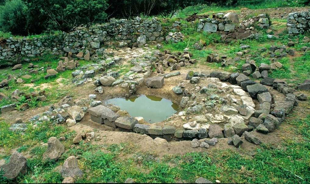
It was one of the most important and prestigious sanctuaries for the tribes of the Recent and Final Bronze Age (12th-9th century BC), who gathered here to celebrate the rituals of the cult of the waters. The sanctuary-village of Abini has characteristics that make it fascinating, mysterious and fundamental in trying to understand the religiosity of the ancient Nuragic peoples. It is located in a valley ten kilometres from Teti, a picturesque village in Barbagia Mandrolisai, a short distance from the banks of the Taloro river and along the transhumance routes towards the plains of Ottana and Campidano. The absence of defensive buildings, the abundance of water and exploitable resources and the position on a connecting road suggest that the sanctuary was a peaceful place of holiness and devotion for numerous proto-Sardinian tribes, as is evident in the considerable size of the site and the enormous quantity and quality of precious votive objects found during the excavations.
It was a group of shepherds and local farmers who began to research the current archaeological area around 1865. According to legend, they were persuaded by a village boy, who had had aa premonitory dream. The first finds - especially small bronze statues - were purchased by private individuals and subsequently donated to the Cagliari museum, while the ‘official’ excavations began at the end of the century. The site includes a village with numerous huts and a sacred well protected by a temenos fence. The huts were mainly circular and in some of them you will notice a counter-seat along the internal perimeter and niches created in the thickness of the walls. Others contained copper slag, so they probably served as artisan workshops. There is no longer a vestibule or access stairway to the well; it originally had a tholos roof and contained a spring. You will be impressed by the size of the enclosure: oval in shape, its main axis measures about thirty metres and the smaller one measures about 18. The internal space is divided into two sectors by a wall running crosswise: the first room, to the east, is smaller and has large granite paving stones and a counter-seat made from the same material. You will notice the traces of two entrances leading towards the spring and the opposite side of the enclosure. The second sector measures twice the length of the first, has an opening to the outside and seems to be an extension of the sacred area, probably due to the growing influx of worshippers. The quantity of artefacts found in the temple makes it possible to consider the site one of the most generous in all of Nuragic Sardinia: dozens of anthropomorphic objects, votive daggers, boats and ingots still to be melted down represent the legacy uncovered during the excavations. A single storeroom, unearthed in 1878, contained more than one hundred kilos of small bronze statues.
Probably the most famous of the statuettes found inside the sanctuary is that of the ‘hero-demon’: a warrior in armour, with shields and estocs, with four eyes, four arms and long horns, currently kept at the archaeological museum of Cagliari.
The sanctuary of Abini is one of the two great Nuragic legacies of Teti, a village surrounded by greenery and rich in traditions. The other is the complex of s’Urbale, a village of 50 huts with nuraghe and Tomb of Giants, which bear witness to life in the Final Bronze Age.
Romanzesu
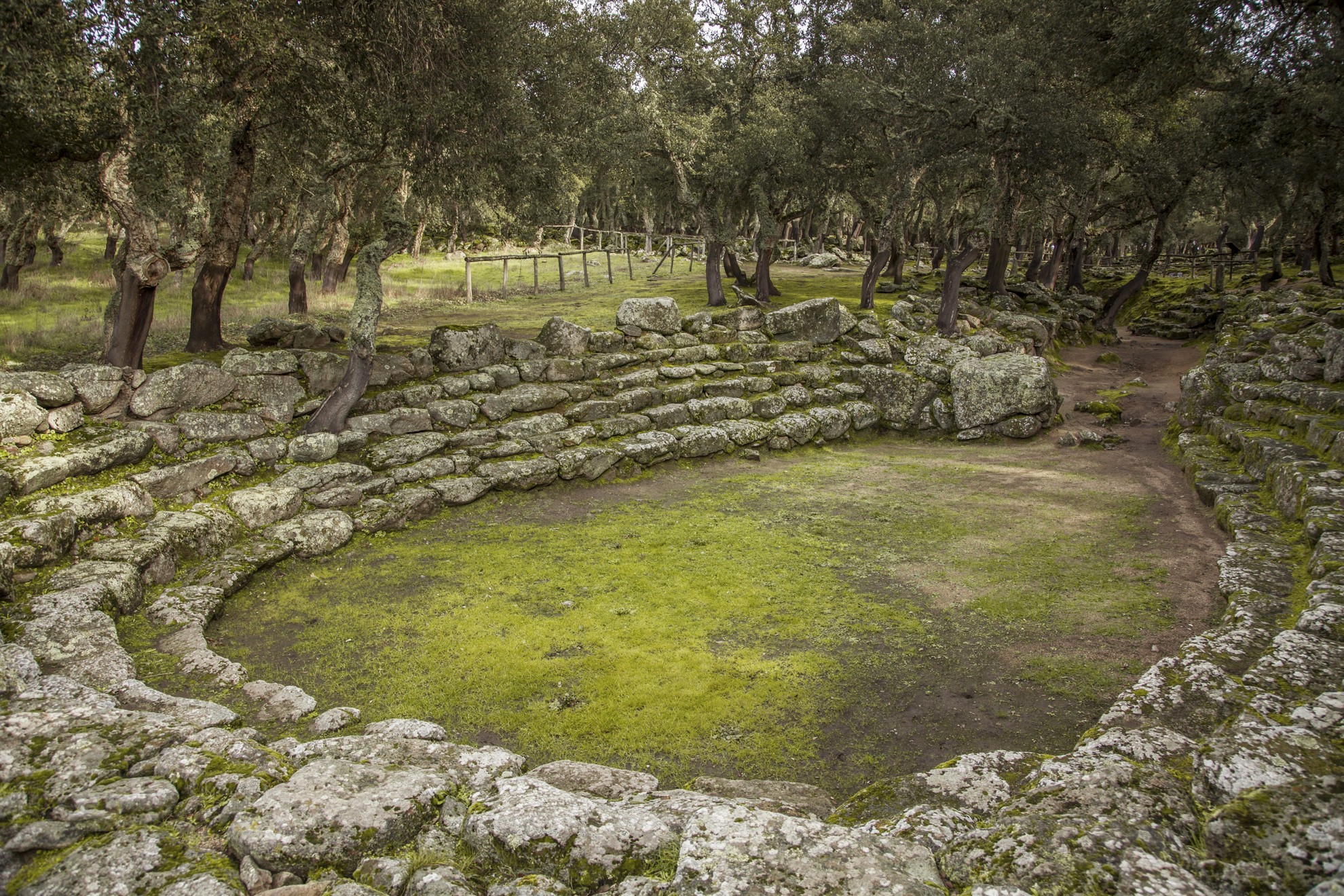
Size, complexity and architectural originality of the dwellings and of the places of worship are the features of a priceless heritage of Nuragic Sardinia. The village-sanctuary of Romanzesu stands on a plateau in the locality of Poddi Arvu, in a forest, near the source of the river Tirso. It is part of the territory of Bitti, which is 13 kilometres away, and it extends for seven hectares. All in granite, it includes about one hundred huts, many hidden by the trees, and various buildings of worship: a shaft temple, with a stepped amphitheatre, two with a megaron, one rectangular, one heeron (with amber artefacts) and a mysterious maze. The name of the place comes from the Roman settlement of the 2nd-3rd century AD. The first information on this site is dated 1919: it was discovered by the archaeologist Antonio Taramelli. Seven excavations that took place at the end of the 20th century have brought us fragments of pottery, bronze and lead.
The monumental heart is the shaft temple (13th-14th centuries BC) and spring water gushes from its fissures. It has entrance steps, a room with a floor and a counter-seat along the wall. It is connected via a corridor over 40 metres long to a circular paved tank, a ceremonial basin in which water was collected. Around it, there are six wide steps of an amphitheatre, where you can imagine the village population crowding in and involved in the collective rituals of the water cult: ablutions and political-religious ceremonies, including trials by ordeal (requests for divine intervention in order to judge crimes). Alongside, three granite baetyluses symbolizing the divinity were found. Near a megaron temple, you will notice an oval enclosure, within a series of concentric spiral walls, that lead, via a labyrinthine path, to a central room: here, a pedestal supported a cultic object. The maze, perhaps the hut of the sorcerer priest, dates back to the 13th-14th century BC, while the village is of an earlier period: the pottery found in the huts date back to the 16th century BC, so in the beginning the spring was only used as a water supply. The huts are circular, with a paved floor and seats placed around the fireplace. Some are very spacious, with niches and internal dividing walls and one even has three rooms that open onto a common courtyard.
Complete the cultural tour in Bitti, a village arranged as an amphitheatre around the church of San Giorgio Martire, with a visit to the Museum of Rural and Pastoral Civilization, inside which there is the multimedia museum of Canto a Tenore, dedicated to polyphonic singing, a UNESCO heritage site, that has made Bitti famous throughout the world.
Is Janas
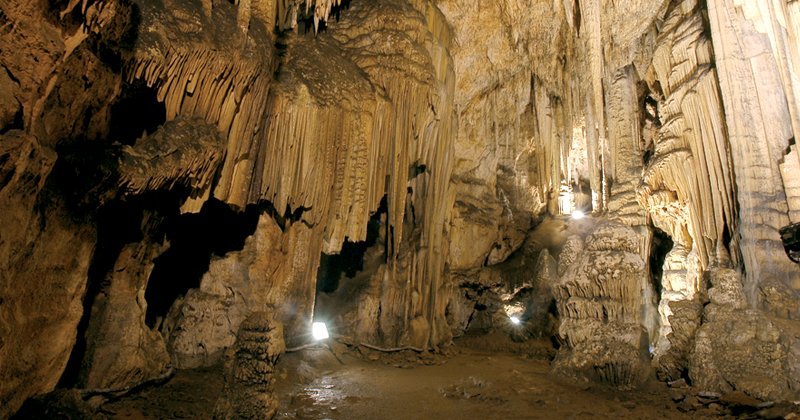
In the heart of the Barbagia di Seulo region, in the territory of Sadali, a small inhabited area between the provinces of Cagliari and Nuoro, an ancient legend enshrouds a lush forest of holm oaks. On the border with the territory of Seulo, a short distance from Su Stampu 'e Turrunu, a 16-metre high waterfall (which should absolutely not be missed) that jets out from a rock, Is Janas is hidden in the luxuriant vegetation. Enshrouded in an aura of mystery the caves, which are 240 metres long, bring to mind ancient fairy-tales and their protagonists, the fairies. It is said that they lived far from prying eyes, preparing delicacies and sweets, and that they were turned to stone by God for having killed (and mocked) an old friar.
The underground cave now contains a very precious natural treasure and unusual wildlife. It is divided into six rooms and there are a few steps leading to the vestibule, which is a large slightly sloping room where unusual stalagmites grow drop after drop, covered by a plant patina. As you go further inside, you will enter the S' Omu de is Janas, the house of the fairies. In this oval room, which is 25 metres long and 8 metres wide, you will find the Janas that - according to legend - have become three impressive stalagmites. Flows, columns and marble drapery make it an enchanting place. From the ceiling, a flurry of white stalactites will dazzle you. After going past the room of the "ancient landladies', you will reach Su Mulinu, the third room with a massive ochre-coloured flow. Nearby, there is a small stalagmite that brings to mind a Madonna with child. The next room is Su Longu, a bare corridor on the floor of which you can admire low columns that overlook a small lake. From here, you will enter the Bridge, a strip of rock that leads to the last room, the room of the Guano: a dense colony of bats has made it their shelter. The cavernicolous wildlife is, in fact, typical in the cave: molluscs, centipedes, spiders, pseudoscorpions, lepidoptera, various types of insects and eutroglophile salamanders are the inhabitants of a place where time stands still.
Sadali is a picturesque medieval village located at an altitude of 750 metres that developed around the Late Byzantine parish of San Valentino. Next to the church, you can admire a waterfall, the waters of which fall into the gulf of Sa Bucca manna (the great mouth). The village is surrounded by forests of holm oak, durmast and cork oaks: not far way, it is worth paying a visit to the Accodulazzo nuraghe, where prehistoric fragments of obsidian and pieces of pottery from the Roman period were found, and the ancient water mill.
Nuraghe Orolo
Like a sentinel, perched on the edge of a promontory, 785 metres high, at the foot of Mount Cuguruttu, it dominates and oversees the Tirso valley and the entire Marghine. The imposing Nuraghe Orolo, a symbol of the picturesque village of Bortigali - famous for its delicious cheeses and a still active watermill - offers a spectacle of unusual beauty: from its summit, your gaze will sweep over a vast portion of central Sardinia, from the Macomer plain to the Abbasanta plateau, all the way to Gennargentu. You can easily get there by car from State Road 131, exiting at kilometre 149.5 at the junction for the hamlet of Mulargia and continuing for a few kilometres along Provincial Road 62. Or you can visit it on foot as part of the 'Nature Trail', which starts in the village (four kilometres from the nuraghe) and climbs Mount Santu Padre.
The monument was restored in 1998 and is in excellent condition! An ancestral scenery surrounds an architecturally elegant structure made of large, square trachyte blocks arranged in regular rows. The nuraghe is large and trilobate, i.e. composed of a central tower (keep) with two floors and a slender profile, to which, at a later date, a bastioned body was added on the front, comprising two smaller towers connected by a curtain wall. The trapezoidal entrance in the centre of the bastion is closed by an architrave with a drainage window above and leads into a walkway covered with a jack arch which in turn 'flows' three ways: to the front into the main tower, to the right and left into the entrances to the side towers. The corridor is cut into the masonry, a perfect work that does not compromise the stability of the building.
The keep, which is circular with a diameter of 15 metres and currently 14 metres tall (once taller), is built with stones of decreasing size: the large, freshly hewn boulders of the base rows gradually become smaller and more refined towards the top. Inside the main tower you can visit two overlapping chambers, on the ground and first floors, both covered with an almost intact tholos (false dome). The lower chamber is circular, six and a half meters tall. Its floor plan is enhanced by three large cross-shaped niches and four compartments in the wall mass. On the right, in the hallway leading to the chamber, you will see the most characteristic architectural element: the staircase built into the thick masonry and lit by six slits at the treads to illuminate the 56 steps (!), almost regular, which spiral up to the upper floors and lead you relatively safely to the top of the keep. The room on the first floor is lit by a large window crowned by a massive architrave and has an irregular floor plan with three niches and two storage pits three metres deep. In a niche there is a slit similar to one in the nuraghe Santu Antine (Torralba), which reproduces a bovine head. The tholos, in excellent condition, is almost six meters high. The staircase continues to the top floor where you will find the remains of a third chamber: originally the tower had at least three levels. On either side of the main tower are two smaller towers. The one on the right, consisting of a circular room (five metres in diameter), is preserved to a height of between one and five metres. The one on the left has an elliptical room with an intact tholos roof. Around the monument, in an area of more than two thousand square metres, there are traces of a dozen circular and rectangular huts and a bastion that defended the settlement. The few pottery fragments that have been found provide evidence that the area was frequented between the Middle and Late Bronze Ages (16th-9th centuries BC), with sporadic Roman evidence (until the 5th century AD).
The Orolo is a must for archaeology enthusiasts visiting the Marghine, a territory that is a treasure trove of evidence from the past.
Nuraghe Nolza
Its mighty structure, built in various phases and consisting of central main tower and a bastion with four smaller corner towers around it, brings to mind one of the most famous Bronze Age monuments, su Nuraxi in Barumini. The nuraghe Nolza is the most important archaeological site in Meana Sardo, a typical village with agro-pastoral traditions, which is seven kilometres away (to the south), as well as the largest in the entire Barbagia di Belvì region. The quatrefoiled building stands on the Cuccurru Nolza, the highest elevation (740 metres) of the schist plateau of su Pranu, on the southwestern edge of the park of Gennargentu. From Meana, the road takes you alongside it, but you can also reach the nuraghe on the Trenino Verde tourist railway line, on the stretch from Mandas to Sorgono: the train stops just 300 metres from the monument.
The majestic central tower, about thirteen metres high (today), dominates a village of huts extending two and a half hectares around it. Research is still ongoing and has so far ascertained that the village represents the original settlement (16th-15th century BC) of the complex. The phases of construction of the Nuragic fortress are demonstrated by the use of different techniques and materials: the keep, two of the four perimeter towers and the eastern and northern curtain walls, dating back to the 14th-13th century BC, were built with schist blocks positioned in irregular rows; the other two towers and the southern and western curtain walls were built around the 12th century BC with porphyry blocks, positioned using the polygonal technique. Close to the walls, more than one hundred perfectly worked blocks of trachyte were found and originally formed the upper part of the monument. The various phases were characterised by renovations and adaptations and, in particular, the keep underwent extensive restoration.
The Nolza, already described in detail in 1842 by the historian Vittorio Angius, was studied for the first time in 1940 and has been investigated since 1988 by the ‘father’ of Sardinian archaeology, Giovanni Lilliu. The excavations, which took place between 1994 and 2000, unearthed the interiors. The room at the top, between the keep and the curtain wall, is particularly interesting and is a sort of ‘courtyard’ devoid of the original tholos (false dome) roof. It is paved with schist paving stones, sheets of cork and beaten clay and has a counter and a hearth made of trachyte stones. The entrance to the first floor of the central tower opened up onto the courtyard. A staircase takes you to the (current) top of the nuraghe where you can observe the splendid landscape that surrounds the archaeological area.
Among the finds, pottery from the Middle Bronze Age and other artefacts of daily use from the Late Bronze Age stand out: bowls, pans, trachyte and granite mills, pestles and sickle elements made of obsidian, as well as animal bones. Another notable protohistorical monument in Meana is the nuraghe Maria Incantada. Other archaeological legacies belong to the Roman era: a spring in the locality of Polcilis and the tombs of s’Enna sa pira and Laldà.