

San Michele arcangelo - Siddi
It is one of the smallest Romanesque churches in Sardinia, but its main feature, which is clearly visible on the façade, is an architrave with images, carved in relief, of five anthropomorphic figures, one of which is upside down. This work, unique in Sardinian medieval sculpture, can be boasted only by the Church of San Michele Arcangelo. The sanctuary was built in the mid-13th century on a small hill that currently represents the outskirts of Siddi, built from brown and yellow marl, sandstone and basalt. The layout has two naves, but quite strangely, only one of the two - the one to the south, which is wider than the other - ends with an apse. The roof is made of wood, with a gabled roof in the main nave and a single-pitch roof in the ‘smaller nave-aisle’.
On the façade, you will notice only one hanging arch. Originally, there was probably a series of arches that ran along the entire façade, but they were lost following renovation work. The two portals both have architraves, with a rounded relieving arch. You will be impressed by the architrave on the left, where the sculpted figures appear within four panels, divided by vertical bands decorated with intertwined diamond shapes. The characters have broad shoulders and slender limbs: their symbolic interpretation still remains a mystery today. The inverted figure is the first on the left: according to the most widely-accepted theory, it represents the fall of Lucifer. Saint Michael, after whom the church is named, and God the Father appear in the second and third squares. The fourth panel presents two figures side by side, which may represent Adam and Eve. Others, however, think that the upside-down figure refers to allegories of death, already present in prehistoric monuments and in the Punic era, while the two characters nearby are ritual dancers. Once through the entrance, you will see that the naves are divided by three arches resting on octagonal pillars. The presbytery is slightly raised from the floor and contains a stone altar and two niches, where two wooden statues of Saint Michael reside. Behind it, the semicircular apse opens with a single-lancet window in the centre. There is also a third portal, on the south side, preceded - like the other two - by steps and above which there is a rounded arch.
Every year, on 29 September, the church is the scene of the celebration of the saint to whom it is dedicated. On the eve of the celebration, a statue of the saint arrives from the Parish Church of the Visitazione di Maria Vergine and is accommodated inside the church. On the day of the celebration, a solemn procession takes place along the town streets and lastly, the day after, the statue returns to the parish church of Siddi, a village that stretches into the valley of the ‘giara’ of the same name, in an area dotted with prehistoric evidence: the Tomb of Giants of sa Domu ‘e s’Orku stands out, imposing, well-preserved and made of basalt blocks. The corridor nuraghe of sa Fogaia, in the park of the same name, is also worth visiting. In the village, you can then visit the unmissable Museum of Agri-food Traditions and the Ornithological Museum of Sardinia, the only one of its kind on the Island.
Tuili
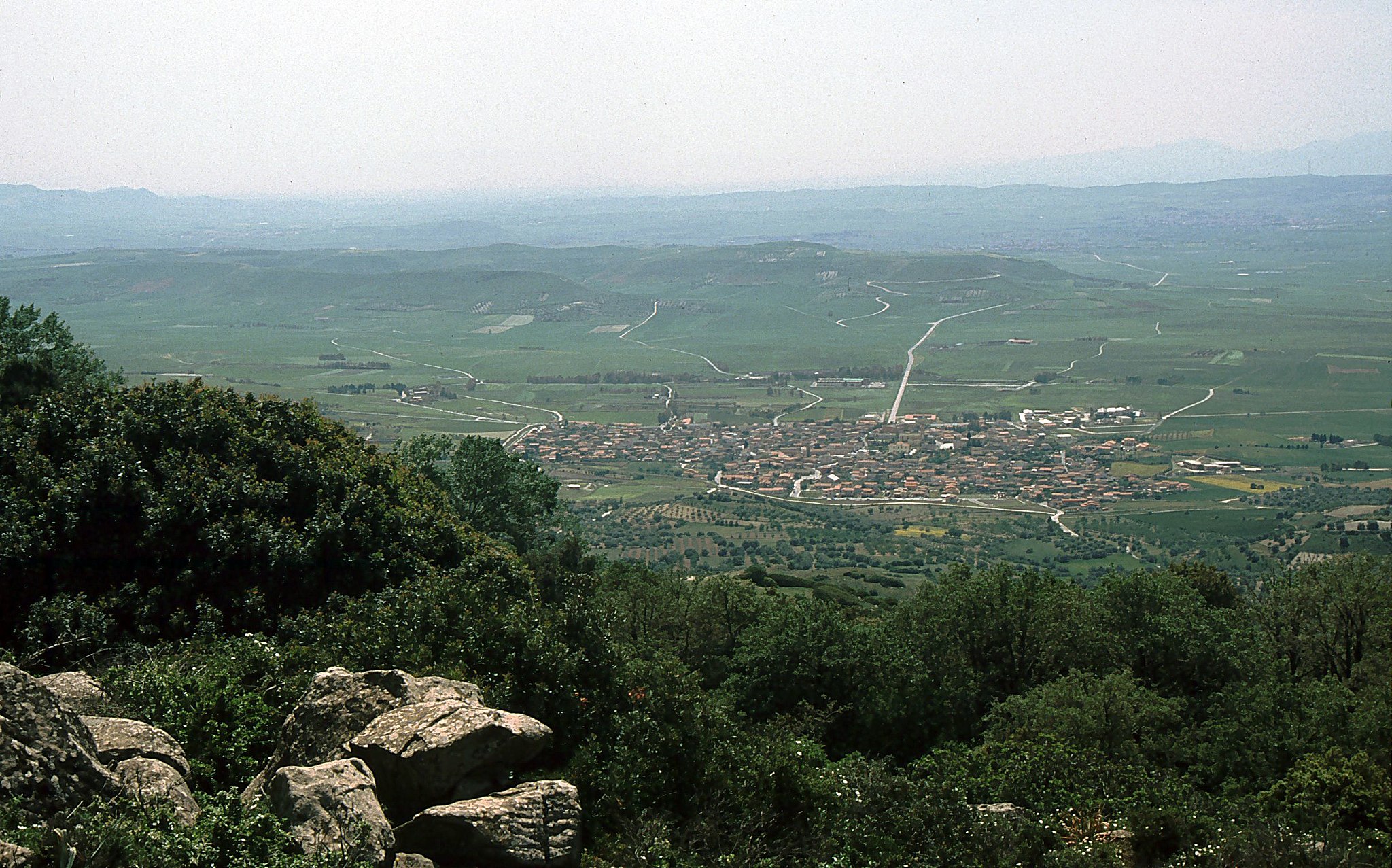
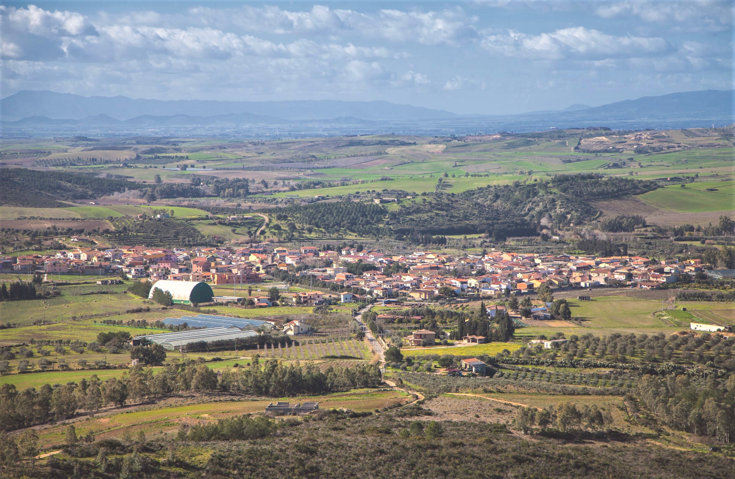
Tuili stretches along the base of a beautiful natural context, in the middle of Marmilla. Tuili, a village with 1,000 inhabitants, is a great place for setting off on excursions through the Giara park, part of which falls within its territory, including the greater marsh and Monte Zepparedda. On the plateau, woods of cork oaks and holm oaks, Mediterranean scrub, ancient olive trees, meadows and marshes alternate. In addition to the famous horse, there are also weasels, hares, martens, fox and birds of prey: the northern goshawk, peregrine falcon and common buzzard. Paulis have created ecological niches, in turn forming the habitat of invertebrate species dating back to 200 million years ago. Archaeological sites are scattered throughout the surrounding countryside, the finds from which are kept in the National Archaeological Museum of Cagliari. In Santa Elisa, there is an obsidian workshop, Phoenician-Punic remains are in the Nuridda area, and a Roman settlement is in Santa Elisabetta.
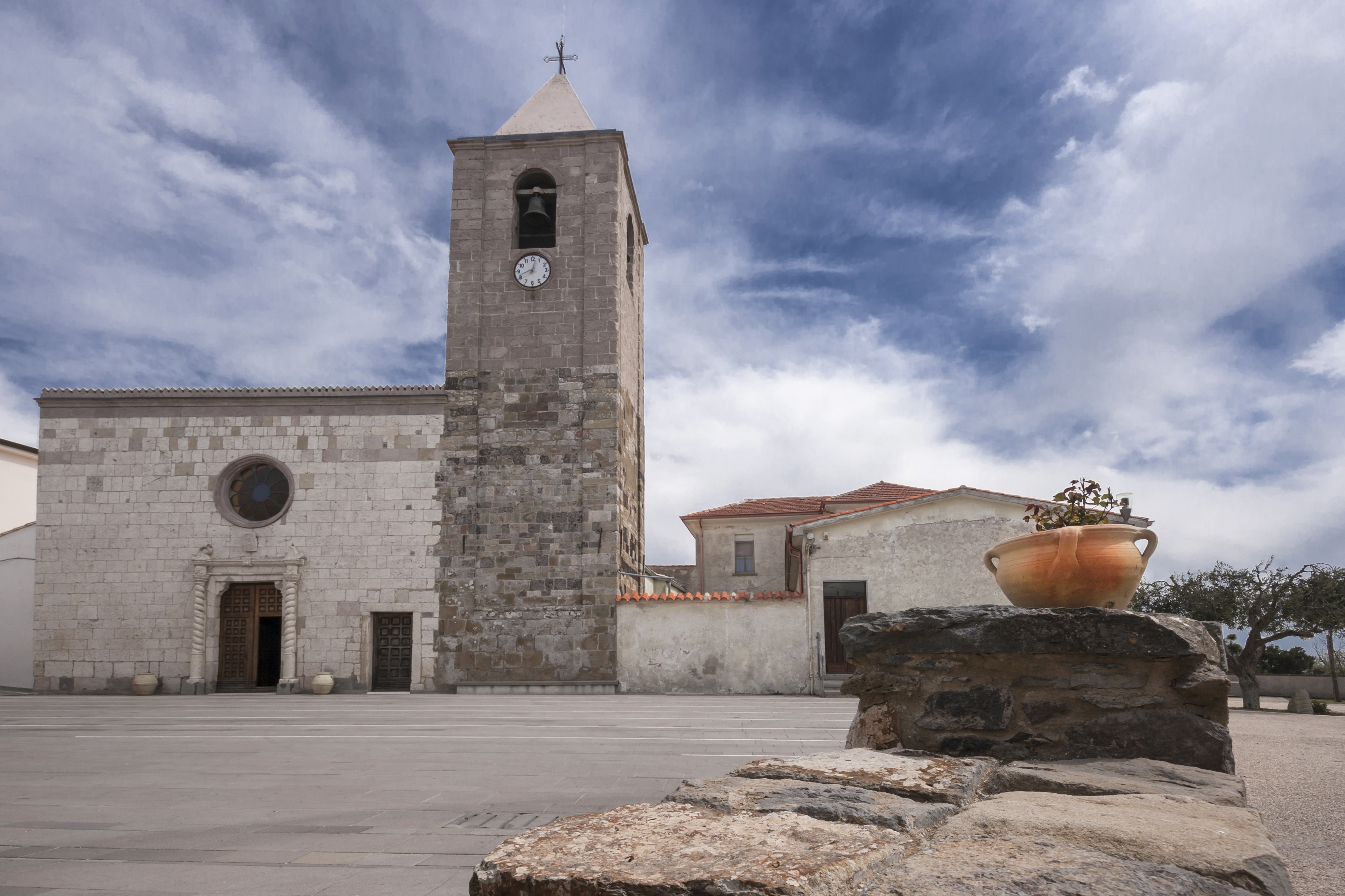
A walk around the Sardegna in Miniatura Park offers an exploration of the island and its history, amidst Nuraghe and dinosaurs. In the historic town, there are refined dwellings and peasant houses in the court, almost all characterised by portals of the late-19th century. Two elegant neoclassical buildings stand out: Villa Pitzalis and Villa Asquer, which houses the olive and oil museum, with historic images, tales and work tools, and the Sardinian musical instruments museum. A special place is reserved for the launeddas. The village has arisen around the parish church of San Pietro Apostolo, built in Gothic-Catalan style and consecrated in 1489. The façade has a double inflection as its crown. Rising on the left is the bell tower, with a square layout and surmounted by a dome on an octagonal drum. The sides are supported by buttresses. In the single nave, there are three chapels on each side, all barrel-vaulted, except the third on the left, which features a starry vault with pendular ornaments, being that remaining of the 15th-century set-up. The church contains interesting marble furnishings, such as presbytery balustrade, a Baroque pulpit (1783) and late-Baroque high altar (1800) in white marble with inlays and bas-relief decorations. Since the 1800s, the first chapel on the right has housed the imposing Retable by the Master of Castelsardo (or of San Pietro), a work dating back to the 1500s that is considered as the masterpiece of Sardinian Renaissance painting. It is 5.5 metres high and 3.5 metres wide, depicting episodes from the lives of St. Peter the Apostle, of Christ and the Madonna, and dozens of saints. The church also houses the Retablo della Pentecoste (1534) and an organ dating back to 1753. Also worthy of a visit in the Santa Luisa area of the Giara plateau on the town’s outskirts is the Chiesa di Sant’Antonio Abate, built in the late -16th century in the Spanish colonial style. The festival in his honour at the end of July is the main festivity of the town.
Barrali
It lies at the foot of Mount Uda, a 'green lung' in the centre of grain-growing plain, on the summit of which there is a lush community park, a destination for excursions and pilgrimages (a church may have been there originally). The territory of Barrali, an agricultural and pastoral centre in southern Sardinia, has clear medieval origins and today has over a thousand inhabitants. It is located in a hilly area on the border between Campidano, Gerrei and Trexenta. The village is surrounded by small, lush elevations, on which vegetable gardens, orchards, olive groves and vineyards are cultivated, and it is located on the banks of Riu Mannu. An excellent olive oil arrives from the fields, along with peaches, oranges, apples and grapes and fine wines are produced here, like Nuragus and Monica. Barrali will also surprise you with its other specialties: from its durum wheat come the traditional breads, baked in approximately forty wood-burning ovens and excellent meats with sheep's and goat's cheeses come from the healthy pastures in the Barrali area.
The name Barrali most probably comes from barralis, meaning 'pergola': many vineyards around here are 'pergola-type'. The presence of humans was documented starting in the Nuragic age, which is confirmed by a watchtower on Mount Uda and another, the most important one, along the road leading to Donori, called sa Domu and s'Orcu, as well as the ruins of su Mausoleu. Not far from the residential area, there are the ruins of the ancient medieval village of Natali.
In the village, the most interesting building is the parish church of Santa Lucia, that many people believe dates back to the early 19th century. Only a few elements of the original village still remain. The patron saint of the village is celebrated twice during the year. On the first Sunday in July, her simulacrum is carried in a procession along the village streets and the worshippers follow it with deep devotion, accompanied by folk groups and launeddas players. The second festivity is in mid-December with mostly religious celebrations.
Serri
Serri sits at an elevation of 600 meters, along the edge of a Giara (plateau), to which it gives its name. According to general belief, it was founded by the inhabitants of the nearby Roman city of Biora as they fled the plague. This small agro-pastoral village on the border of Sarcidano plateau and Trexenta, has a population of 650 and is a member of the Borghi Autentici d’Italia Association because of its natural, cultural, archaeological and culinary riches. The village boasts a view that spans from Gennargentu to Marmilla Hills and the island’s south-western coast. Giara di Serri, close and similar (on a smaller scale) to Giara di Gesturi (Jara Manna), is a natural fortress surrounded by century-old holly, downy and common oaks, and Mediterranean shrubs; an ideal setting for excursions on foot, bicycle or horseback. Its lush greenery is flanked by fertile pastures, where excellent cheeses are made, vegetable gardens, orchards, and vineyards producing superb wines. Meat and excellent oils are at the foundation of local recipes.
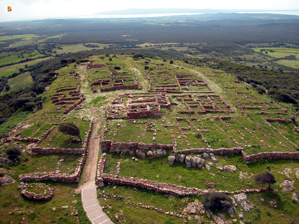
Giara di Serri is an open-air museum housing a prehistoric architectural “jewel”, the Sanctuary of Santa Vittoria, a symbol of piety and a crossroads of culture and commerce where you can observe the evolution of Nuragic civilization. It is composed of four groups of buildings: a holy area with a Well Temple and a “hypaethral” temple with two altars linked to a Priest’s Hut; the large Festival Enclosure, an area for social and commercial activities; a group including the Enclosure of Double Betyl; and a fourth complex, where the “Torture Enclosure” and the “Curia”, where the federal assembly of chiefs likely met, are most notable. In the various buildings, nuraghe-altar models, taurine protomes, weapon fragments, bracelets, rings, axes and above all, bronze statuettes (ex voto) made with great skill as well as other objects of everyday Nuragic use were unearthed. All are now on display at the National Archaeological Museum in Cagliari. The site continued to be used for worship into the Byzantine period: in the 7th century, this was the site of the Church of Santa Maria della Vittoria, which was rebuilt by Vittorini monks in 11-12th centuries and gave its name to the site. Its altar niche houses a polychrome wood statue of the saint, whose Feast Day is on September 11. The sanctuary is the most significant of Serri’s archaeological inheritance, which ranges from the nuraghes, such as s’Uraxi, to Medieval period sites.
The town’s historical centre is composed of old rural homes with spacious courtyards and arched entrances. The town lives mainly off agriculture, animal rearing and crafts including bread making, embroidery, basket weaving, and wood carving. Original it was built around the Parish of San Basilio Magno, a Pisan Romanesque church with Byzantine influences built around 1100. The interior is adorned with a 18th century high altar in marble and three 17th century, Baroque style wood altars. The patron saint’s Feast Day is celebrated in late August. In the old section of town, next to the former monte granatico (grain bank, currently a cultural centre), stands the small Church of Sant’Antonio Abate (1770). Mid-January, a large bonfire is lit in the square in front of it in honour of the saint. A few days later, the Feast of San Sebastiano Martire is celebrated. Of the sanctuary dedicated to him remain only ruins next to which some Roman artefacts have been found. On the eastern slopes of the plateau, the churchyard and large square near the Country Sanctuary of Santa Lucia play host to the saint’s feast in late of May, and the associated cattle market-show.
Nuraghe Concali
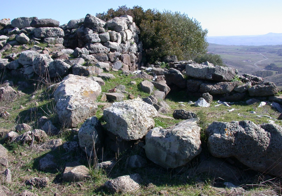
It was part of a real system of ‘control towers’, in visual contact with at least four other nuraghi located near the Giara di Siddi and theCollinas plateau, and both the characteristics of its construction and the presence of mysterious marks on rock make it intriguing, giving rise to a popular belief. The Nuraghe Concali stands on top of the mountain of the same name, two kilometres north of Collinas. Its structure is complex, with a central tower partly included in a twin-lobed bastion, surrounded by a barricade. To the west, the bastion appears to incorporate a previous building, with a sub-circular layout, defined by some as a ‘pseudonuraghe’.
The nuraghe was built from basalt blocks, taking advantage of the natural rock outcrops. From the main tower of the nuraghe, with a tholos roof, two masonry arms delimit the courtyard, with a second tower overlooking it. The vegetation covers a third tower, which is smaller in size.
Other curtain walls connect to the keep, incorporating external courtyards, and one connects to the pseudonuraghe. To the south, there are traces of walls dating back to later historical phases and therefore the nuraghe Concali was probably reused in a historical period. Based on the ceramics found, it was first built in the Middle Bronze Age (17th – 14th century BC). Near the nuraghe, you will notice a rock with mysterious marks that seem to have been engraved on its surface, seemingly shaped like hooves. Popular tradition has given rise to a legend: the signs are said to be the hoofprints of Luxia Arrà, a ‘centauress’ - half woman, half winged horse - who took off from this rock to reach the valley. According to the legend, this is the location of the petrified pitchfork with which Luxia is said to have speared her beloved, after which she went mad forever and become Arrabiosa, meaning furious.
Six kilometres to the west, at the foot of the small Giara di Collinas, you will find the Giants’ Tombs of sa Sedda ‘and sa Caudela. Their unique characteristic is that they date back to different periods: tomb A, the oldest, is of the dolmen type and paved with basalt slabs; Tomb B has a pebble floor and was built in overlapping rows with gradual projection. When choosing the next stages of the archaeological tour of the area, you are spoilt for choice: a few kilometres from Collinas are the nuraghe Genna Maria in Villanovaforru, the Giants’ Tomb of su Cuaddu de Nixias in Lunamatrona and the two main archaeological sites of Siddi, the majestic Giants’ Tomb of sa Dom’e s’Orku and the archaeological-nature park of Sa Fogaia.
Monte Sirai
From Monte Sirai, a low elevation near Carbonia, the coasts and islands of Sulcis and the valley of Cixerri as far as Campidano can be monitored. The Neolithic and Nuragic civilisations that first occupied the area knew this and the Phoenician and Punic peoples who later settled along the access route to the sea and the plains also understood it.
On the plateau, the Phoenicians, who had built Sulky on the island of Sant’Antioco a few decades before and had become integrated with the Nuragic community, founded a town (750 BC) that lived in prosperity between the 7th and 6th century BC. In 520 BC it was occupied by the Carthaginians, who, after a period of decline, fortified it (mid-4th century) and completely rebuilt it (250 BC). The Roman occupation in the 2nd century did not affect the inner part: there are no other Phoenician-Punic colonies with evidence as complete as here.
On Monte Sirai, coloured by red stones covered in moss, there are houses, squares, a temple, a tophet and a necropolis (Phoenician shaft tombs and Carthaginian hypogea). At the entrance to the acropolis, there is the pomerium, an inviolable sacred boundary for the Phoenicians. The town extends around the fortified tower - built on a nuraghe - that had been a defensive fortress for centuries and became a temple in the 3rd century BC. The statue of Astarte, a Phoenician divinity, bears witness to this and is now kept at the Archaeological Museum of Cagliari. On the acropolis, the houses, consisting of rooms positioned around a courtyard, paint a picture of opulence, especially the Fantar and Lucernario di Talco houses, where a transparent mineral filtered the sunlight lighting up the rooms.
The boundary wall was reinforced by the Punics in 370 BC. The tophet, a necropolis for children, also dates back to the same years. In the urns, shaped like a covered pot, are the ashes of the deceased children buried with small animals, amulets, jars and jewels. There was a temple above it. Part of the tophet has been reconstructed in the Villa Sulcis museum of Carbonia, where you can use multimedia equipment to enter the Punic town. At the end of the 6th century BC, the types of funeral changed: from cremation in the Phoenician period to entombment in underground sepulchres with access corridors. The Punic necropolis had 13 tombs, eleven carved out of the tuff and two obtained from pre-existing domus de Janas.

Cripta di Santa Restituta
A quarry for limestone blocks, a Phoenician religious site, an amphora deposit, a place of Christian worship, and a shelter in the second world war. The crypt of Santa Restituta, one of the symbols of the picturesque neighbourhood of Stampace, has had a turbulent history, marked by periods of abandonment and with a happy ending in the restoration during the 1970s. The hypogeum has a central space connected to the outside by two stairways carved into the rock. The walls were once painted: the wall showing Saint John the Baptist with his right hand raised in blessing (13th century) still remains. The central altar features a marble statue of Santa Restituita, while the smaller altar used to hold simulacra of Saints Giusta, Giustina and Enedina. You can feel that the church is dug out of the rock as soon as you enter, from the small square of the same name a short walk from the Crypt of Sant'Efisio.
Part of the building is a natural cave, and part is excavated. In the late-Punic period it was a limestone quarry. Findings of votive objects show that it later became a place of worship. The cave was also used during Roman and paleo-Christian times as a warehouse for amphorae up until the 1st century AD, before being abandoned for twelve centuries. In the 13th century it was consecrated to the African martyr Santa Restituita, whose relics had been held in Sardinia since the 5th century. It was then abandoned once more when the new and nearby churches of Sant'Anna and San Francesco were opened. It was rediscovered in the early 17th century. After finding the relics (1614), the bishop began work on improving the altar, creating three niches and the underground crypt with the martyr's column. The central aedicule held the relics of four saints. During the second world war, the hypogeum was used as bomb shelter during raids. The relics were hidden in Sant'Anna to protect them. There, they lay forgotten until they were rediscovered inside a 17th century urn in 1997.
When touring the religious sites of Cagliari, other unmissable monuments include: Santa Maria cathedral and the Santuario dei Martiri, the basilica of Nostra Signora di Bonaria, a Christian temple in Sardinia, with its monumental cemetery and the paleo-Christian sanctuary of San Saturnino.

Anfiteatro romano di Cagliari
Mentioned in 19th century letters and studies, the Roman amphitheatre in Cagliari was rediscovered during the Romantic period, with its passion for the ruins of ancient civilisations.The first excavations by canon Giovanni Spano (1866-68) were followed by archaeologist Doro Levi's digs (1937-38) and the restoration of the majestic building.
During the first imperial age, neighbourhoods and public buildings were built in Carales, followed by the amphitheatre from the late 1st and early 2nd centuries AD, set in the southern foothills of the Buoncammino hill. It originally occupied more than a thousand square metres, with a 120 metre perimeter and a 20 metre high facade decorated with columns and statues. Part of the stands (cavea), the arena, corridors and other areas were carved from the rock, while the rest was built using white limestone blocks.
Today you can admire part of the cavea and underneath, the gladiators' rooms, the cells for the animals and the infirmary. These were the times of the games. The stands, on three levels, could hold ten thousand spectators of all social classes, who could watch fights between men and beasts imported from Africa in the morning, executions at lunchtime, and in the evening, after the banquets, the most popular event of all: fights between gladiators recruited from the island and elsewhere, who underwent arduous training in what is now the Orto deiCappuccini. Imagine the stands full and the illustrious decuriones sitting on the podium with its marble paving, sheltered from the sun by the velarium.
The amphitheatre was also used to collect rainwater: the funnel-shaped cavea allowed the water to flow into a well. With the arrival of Christianity, the gladiator fights lost popularity until they were banned by law in 438 AD. The building was then used as a quarry. The site continued to be despoiled until the 19th century. Today it is partly covered by a structure in iron and wood that was used to host shows and concerts from 2000 to 2011, before the long and difficult process of restoring it as an archaeological site began. In your tour of Roman Cagliari, in addition to the amphitheatre you'll also find private homes such as the Villa di Tigellio. Nearby, don't miss the Botanic Gardens, a green oasis in the heart of the city, or the Roman remains preserved in the CitadelladeiMusei, Sardinia's largest and most complete museum complex.

Regional Nature Park of Gutturu Mannu
The name in Campidano dialect means 'great gorge'. It is a canyon crossed by the torrent of the same name and covered in greenery: one of the most popular destinations for hiking enthusiasts. The regional park of Gutturu Mannu extends through the territory of ten Municipalities in the southwestern part of Sardinia: three near Cagliari - Assemini, Capoterra and Uta, where the oasis of Monte Arcosu lies; another seven in the Basso Sulcis area, where the forests of Piscina Manna - Is Cannoneris are located: Domus de Maria, Pula, Santadi, Sarroch, Siliqua, Teulada and Villa San Pietro.
One of the largest forests in Italy is located inside the park: 35 thousand continuous hectares of priceless nature value. You will find yourself in dense holm oak forests, particularly between 700 and one thousand metres of altitude, you will see yew and holly trees in the most remote clefts and you will admire beautiful cork oaks in the central part. You will be inebriated by the Mediterranean scrub that fills the air with its fragrance: carob trees, strawberry trees, heather, arborescent phillyrea, mastics, myrtle and wild olive trees. Beyond the green expanse, you will be struck by the picturesque torrents and springs.
You can enjoy the shade, especially on hot sunny days, or go for walks in spring and autumn, surrounded by the sounds of nature. You will quite possibly come across endemic species of Sardinian wildlife, like the deer, the goshawk and the Italian cave salamander. The park has three oases of protected wildlife: Pantaleo, Gutturu Mannu and Monte Arcosu, which is the property of the WWF, where the fallow dear wanders freely, and Piscina Manna-Is Cannoneris. The undisputed predominant species is the wild boar, but other animals populating the area are weasels, wild cats and foxes. It is not unusual to see the golden eagle, the peregrine falcon and the buzzard flying overhead.
If you want to take a break, you will find picnic tables in the Fanebas site. Before setting off again, visit an area in which archaeologists have discovered artefacts from the Nuragic period to the Early Middle Ages, a mountainous corner where history and nature have come together to create a very charming mosaic.

Necropolises of Corongiu and S’Acqua Salida
They are nearby and contemporary to each other, yet different, both in terms of architectural development and decorations: these are surrounded by an aura of sacredness alongside the ‘classic’ prehistoric themes. The necropolises of Corongiu and S’Acqua Salida – also known as Pranu Efis, from the name of the locality in which it lies - are located slightly north of the town of Pimentel, just one kilometre away from each other. Carved into sandstone banks, they date back to the Final Neolithic period, between the 4th and 3rd millennium BC, but their use probably continued at least until the Early Bronze Age (18th-16th century BC). Coming from the town, first you will encounter the Domus de Janas of Corongiu. Two have been identified, a few dozen metres apart, but only the one to the east is decorated. It consists of an access well, an anteroom and a main room.
You will be surprised by the engraved decoration, painted red, that appears on the entrance wall of the room, above and on the sides of the door. At the centre of the upper frieze, there is a vertical element that extends upwards in two spirals: it has been interpreted as the stylised face - with a nose and eyes - of a divinity, perhaps the Mother Goddess. Other spirals, double circles and ‘boat-like’ figures appear on the sides of the door and the upper decoration.
Continuing north you will come across the two centres that make up the necropolis of S’Acqua Salida, located 150 metres apart. The Domus numbered from 1 to 4 belong to the first group. These are mixed in type: well-type and running horizontally; the remaining three are all well-type tombs. In Tomb 1 you will notice various building phases: it was originally a well-tomb, but later on a long access corridor was built and the room was enlarged, annexing three small spaces pertaining to a nearby entombment. The antechamber has traces of red ochre paint. Tomb II still contains traces of two pillars that supported the ceiling, now partly collapsed, while on the floor there is a pool with cupules. Here too, there are traces of paint, with depictions of bull protomes. Tomb 4 has a circular room, imitating a residential hut: in fact, the decorations that appear remind you of housing structures. Near the first group of entombments, there is a sacred area, with a hearth and cupules, where funeral rites were probably carried out. In the second group of tombs, you will see other decorative elements, such as niches, counters and pillars, particularly in tomb 6. A further decorative element appears outside, in the layer of rock above the tombs, consisting of numerous cupules that contribute to fuelling the mystical and spiritual aura of the place.