
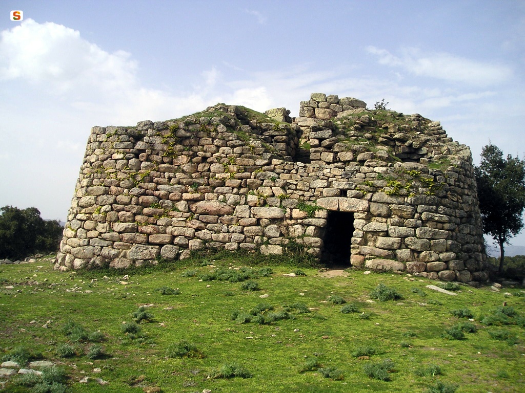
Nuraghe Loelle
It suddenly appears along the road that connects Buddusò, the centre of Monte Acuto, on the border of Gallura, to Bitti, a town in northern Barbagia. The Nuraghe Loelle, hidden among cork oaks and holm oaks, gradually shows its fascinating and mysterious features, perched on a granite outcrop, the main local rock, as it dominates the plateau and the houses of Buddusò.
Its structure is formed by a central tower that leans against a trefoil bastion and it is considered to be of the ‘mixed’ type, as it has characteristics of both ‘corridor’ and tholos nuraghi. In fact, it is assumed to be a protonuraghe converted in subsequent phases to respond to renewed architectural and cultural needs. You will notice the traces of the village of huts, with a circular layout, all around. As you enter, you will be surprised to see that the entrance does not open onto a courtyard or a corridor leading to a central room, as was customary in these Bronze Age buildings. In the Loelle, on the other hand, a flight of steps takes you in a clockwise direction around the tower, leading directly to the second level. Another corridor starts here and, if followed entirely, descends to the ‘ground floor’, while about halfway along it, another ramp climbs to the third level, where the last and main room opens up. Before entering the room, you will notice an apse-shaped niche on the right.
In front of the keep, a bastion crossed by corridors was built, with curtain walls that have a concave-convex line. Outside the bastion, on the east side, there is another distinctive feature of the Loelle: by exploiting a natural ravine, a separate room was created, with a tholos vault, which opens up about one metre below ground level. Moving about a hundred metres away from the nuraghe and the village, you will find a Tomb of Giants, of which the rows of the corridor and traces of the exedra are visible. Not far away, hidden by oaks and holm oaks, a second tomb appears, also with a few surviving traces, and a small dolmen. The latest mystery that the Loelle area reserves is the probable existence of a sacred well: the news comes from various sources but so far no trace of it has been found.
Along the road from the nuraghe to Buddusò, which is part of a stage of the Rally Italia Sardegna every year, you can also visit the necropolis of Ludurru, dating back to the Final Neolithic period: it has six hypogea dug out of a single granite outcrop. Instead, in the opposite direction, towards Bitti, you will come across one of the greatest expressions of the Nuragic age: it is the Romanzesu village-sanctuary, in the middle of a wood, made up of about a hundred huts and various buildings of worship, including a temple well with a stepped amphitheatre, two with a megaron and a mysterious labyrinth path.
Park Oasis of the Tepilora
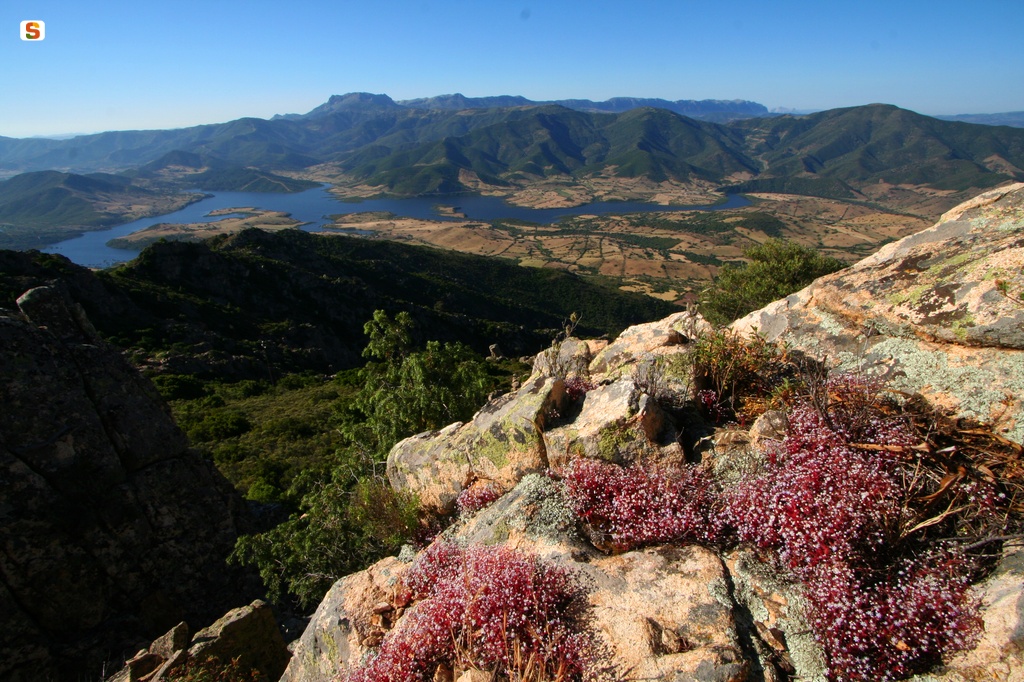
Man has protected it, making it green again and usable. A story of great respect for nature characterizes the regional park of the Oasis of Tepilora, which is, in reality,‘very young’ (established in 2014), but which had a long gestation period. Above all, it has great natural and historical-cultural value: almost eight thousand hectares of unspoilt forests, trails, springs, rivers and ‘dunes’ in the territory of Bitti, Lodè, Posada and Torpè.
Between 1980 and 1986, the two main areas, Tepilora and Crastazza, were reforested, using conifers for the process. The entire perimeter was equipped with infrastructures and services and the new vegetation supplemented the spontaneous Mediterranean vegetation. In the reforestation, numerous species found refuge: the wild boar, the Sardinian hare, the fox and some types of fallow deer and mouflon.
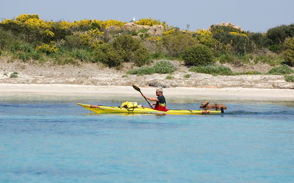
The park extends from the woods of Tepilora as far as the mouth of the Posadarivulet, an element connecting mountain and sea. Its delta with meanders, bends and fossilized outlets, is the result of thousands of years of evolution. Reed beds, tamarisks and bullrushes ensure the optimal nesting conditions for cormorants, egrets, herons, flamingos, black-winged stilts and even the western swamphen. The Posada branches off into two directions: one of them connects to the Longupond, the ideal context for kayak excursions.
Mount Tepilora is the distinctive element of the park: a triangular rocky peak that stands out behind the wooded areas of Crastazza and the forest of Sos Littos, protected since 1914. The golden eagle characterizes the wild nature of the area. Excursions continue on to Montalbo, with a dense network of trails running through the greenery, while the white lunar desert dominates the summit; you can reach the artificial lake of Maccheronis, which is ideal for bike rides along the modern cycle lanes; lastly, there is the forest of Usinavà, featuring rocks that have been shaped over time by the weather, taking on forms from the animal world.
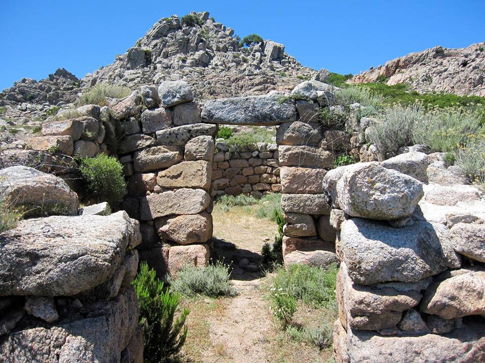
Sanctuary of Sos Nurattolos
Quiet and barren granite hills shaped over centuries by the wind and rain, valleys full of oak trees that cut the horizon, and streams that come together into pools and ponds. That is the gorgeous scenario of punta Senalonga, a promontory that dominates the high plain of Buddusò, home to a splendid example of a Nuragic sanctuary, the sos Nurattolos. This most remarkable archaeological treasure, located in the Alà dei Sardi region, is dedicated to water worship and was discovered in the second half of the XX century. It dates to between 1600 and 900 BC. To get to it you have to pass through the little ‘granite’ town on the border between Gallura and the Nuoro region. After parking your car, walk along a trail of steps and pebbles that leads up into the lush vegetation and to the summit at Senalonga, a thousand metre peak where the beauty of nature gives way to the precious prehistoric remains. The signs of the passage of Nuragic man are at the top: a sacred well inside an irregular courtyard where a circular hut, most likely used for rites and rituals, covers the well of the perennial spring that allowed pilgrims to seek purification. You can continue along the sacred trail after a dip to explore an ‘a megaron’ temple surrounded by a spiral enclosure. The building is made up of two concentric circular rooms. It is a characteristic and mysterious place which probably held animals soon to be sacrificed or where oracles were consulted. The rituals were perhaps aimed at a divinity that dispensed life from the bowels of the earth. The Nuragic peoples turned to this divinity to plead for health and fertility. A bit further on you will see another large hut, circular and with an entrance area and room. It seems to have been a public space, a meeting hut typical of many Nuragic villages. Pilgrims will have stopped here to consult with the priests about matters that concerned him.
From the sos Nurattolos hilltop you can enjoy a vast panorama and head down into the valley where there is the Boddò nuraghe and a Nuragic village known as su Pedrighinosu. A place where ancient remains blend seamlessly with nature, like the Fossu Malu falls. Not far away you’ll see the flat gravel roads of Alà, where every year they do test runs for the Rally d’Italia Sardegna, a leg of the WRC.
Monte Limbara
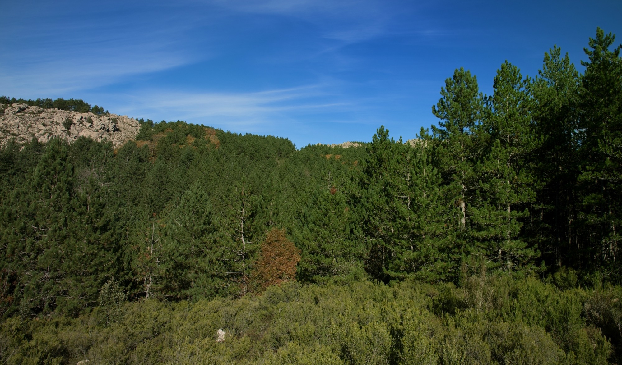
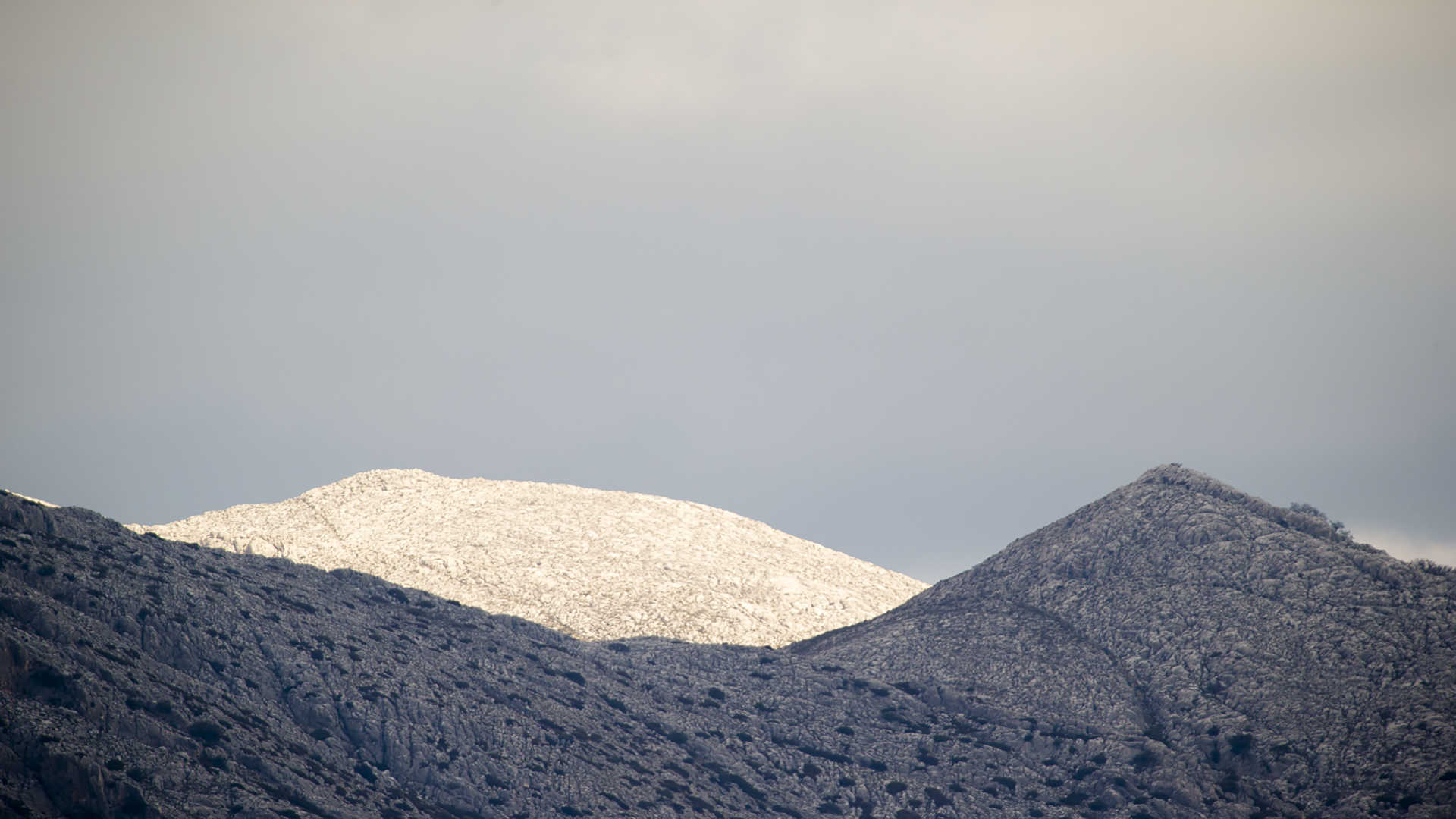
Over thousands of years, water and wind have eroded its granite rocks, giving them bizarre and spectacular shapes, making them seem almost suspended, whitened by the snow in the winter and shining with every shade of green throughout the rest of the year. Monte Limbara stands majestically in the northeast of the Island, and was already given the nickname of limes Balares by the Ancient Romans, because it marked the border between Gallura, inhabited by the Corsicans, and Monteacuto and the eastern part of Logudoro, inhabited by the ‘Romanized’ Balares people. The territory of the massif is situated in four municipalities: the northern and northwestern slopes are in Tempio Pausania, the eastern slope is in Calangianus, the southern slope is in Berchidda and the southwestern slope is part of Oschiri.
The green mantle varies according to altitude: bushes prevail on the peaks, while at medium-low altitude the mountain range is covered in shrubs of Mediterranean scrub: strawberry tree, heather, phillyrea and mastic grow in the moist soils, while cistus, dwarf juniper and broom grow in the more arid soils. Despite fire damage, the holm oak is still dominant in some places and, in the valleys, is associated with maple, holly, ash and yew trees (rare on the Island). In other areas, instead of the ‘old’ holm oak and cork tree woods, conifers have been planted. You will also notice also the quaking aspen and, along the watercourses, oleanders, black alders and willows. Rare plants are hiding in the undergrowth, such as Limbara ribes, Corsican viola, and royal fern - three of the territory’s 56 endemic species - and it is also the home of mammals such as the wild boar, the weasel, the hare, the marten, the fox and two reintroduced species, the fallow deer and the mouflon, symbols of Sardinian wildlife. The golden eagle, the ‘sovereign’ of the Limbara skies, flies over the peaks, along with the northern goshawk, the peregrine falcon, the buzzard and the Eurasian sparrowhawk. Among the amphibians, there is the European mountain salamander and the painted frog.
Much of the territory is managed by the regional agency Forestas, which has divided it into two forest sites and has set up various hiking trails there, with names that evoke the particular features of the mountain, some of which can be covered by mountain bike. The nine kilometres of the ‘tafoni’ itinerary leads to the discovery of granite rocks eroded by weather; the ‘link’ through the woods and artificial ponds, populated by aquatic birds and fish; ‘animals and plants’ leads to the fence where mouflons and fallow deer live; the ‘southern side’ leads from the peaks into the southern valleys. The ‘summit’ trail is 12 kilometres long and crosses the Pavari garden - with species of exotic plants – and reaches Punta Balistreri, the highest peak of the Limbara (1362 metres), which was named after a fugitive from Tempio Pausania who took refuge there in the 17th century: he was never found and was protected by the mountains and by a community that supported him. The Summit was first a communications base for NATO and then for the Italian Air Force. Nearby, there is a small church, Chiesetta della Madonna della Neve. Other summits at high altitudes are Berritta, Bandiera and Giugantinu. ‘The way of the waters’ is the 30 km trail that reaches the countless sources of excellent quality low mineral content water dotted over the slopes of the massif. 29 water sources and fountains have been counted and are all made of granite, blending perfectly with the environment and surrounded by greenery. Various specific itineraries with refreshment and picnic areas make it possible to visit them. All around, the views will leave you breathless: from the valleys around the Coghinas lake to the northwestern coast.
The mountain is part of the history of climbing: the first climbs on the Island took place here (1921). There are numerous classic climbing itineraries, known as clean (meaning that the rock is left unaltered) even to a height of over 200 metres. The climb at Monti Longu, also known as Torre Littaghjesu stands out. It is one of the most beautiful granite peaks on the Island. Every year the Limbara hosts a musical event of international fame, Time in jazz: the music rings out between the rocks and woods, a picturesque setting for rhythmic expressions. The Semida (path) ecomuseum of art and nature is located on its slopes: visitors are accompanied on a journey of discovery of works of art set in the natural oasis, while down in the valley, on the outskirts of Berchidda, the land of Vermentino wine, you will find the wine museum as well as the regional wine shop: the ethnographic-oenological journey illustrates the cultural aspects of wine production in Sardinia.
Monte Albo
Travelling along the Strada Statale 131 trunk road from Nuoro to Olbia, you will be captivated by its white majesty and its precipices. Monte Albo, which gets its name from the light colour of the limestone rocks, has an elongated ridge, of about twenty kilometres, that dominates the Baronìe sub-region. The massif, situated mainly in the territory of Lula and Siniscola and partly in that of Galtellì, Irgoli, Loculi and Lodè, is so rich in vertical gorges and caves, vertical walls and deep ravines, that it deserves the name of 'Sardinian dolomite'. The caves have often been used as places of refuge. In that of Bona Fraule, perhaps a place of worship in times gone by, iron daggers and swords were found. Many of the peaks of the limestone bastion are over a thousand metres high: the summits are Punta Turuddò and Punta Catirina, where the cave of Janna Manna opens up and is 200 metres long. The 'twin' peaks face each other and each is 1127 metres high. Between them, there is the ponor of Tumba e' Narrai.
The mountain has well-marked hiking trails: along the crags and passes you will see beautiful scenery. There are not many wooded corners and there is Mediterranean scrub, as well as endemic species everywhere. Not surprisingly, the Botanical Society has listed Monte Albo as a place of national interest. The rugged territory is densely populated: you can come across wild boar and mouflons on the rocks or martens and wild cats climbing up the centuries-old pine trees. On the snow-covered peaks, the golden eagle, the goshawk, the common raven and the red-billed chough fly overhead. In the northern part, as you climb, rocks appear where the vegetation becomes more sparse. It will look like a 'moon' landscape to you, especially the very white Punta Sos Aspros. Granite outcrops appear all around, as well as little basalt plateaus, known as gollei.
Man has inhabited this mountain at least since the Neolithic age, as is demonstrated by Domu de Janas of Mannu 'e Gruris. Numerous Nuragic evidence exists on the peaks, like Littu Ertiches. Dating back to the Roman age, there is, in particular, a bronze statue of the god Asclepius. Along the trails, you will also notice signs left more recently by man, particularly the pinnettos made of stone and wood, which were shepherds' dwellings for centuries.

Isuledda
An isolated paradise for a dream holiday. 50 metres of sand, formed by the mouth of the River Liscia, connects the mainland to Isuledda, also known as Isola dei Gabbiani, a name that has become common more recently, due to the presence of a camping with the same name. The peninsular, surrounded by crystal clear sea in tones of blue and turquoise and overlooked by the green vegetation, covers 18 hectares within the territory of Palau. In what is also a small sanctuary for marine mammals, you'll also find disabled services, campsite and caravan parking, a large car park, boat and beach equipment for hire, bars and restaurants.
The coast is suitable for families, young people, couples and singles, as well as active or sporty tourists. On one side there is the Spiaggia dell'Arenaria, and on the other the Porto Puddu beach (or Porto Pollo). The two beaches are fan-shaped, surrounded by dunes up to 20 metres high that run directly into the sea. The shore has cream coloured sand, while the water is shallow and the sea bed slopes gently, making it safe for children to play in and perfect for diving and snorkelling.
The thermal conditions guarantee a gentle breeze all year round, without strong gusts, while the position ensures perfect exposure to north-westerly winds. For this reason, Isuledda has become the symbol of Sardinia for windsurfers, kite surfers and fun-boarders, both amateur and professional. It attracts champions from all over the world, who can choose between the western beach upwind, or the eastern one downwind. Or between Porto Pollo and the nearby Barrabisa.
The panorama of Cavalli island will open before you, with the islands of the Maddalena archipelago in the distance: Spargi, Spargiotto and Budelli. During your stay in Palau, don't miss the chance to enjoy other coastal paradises such as Cala Trana, Porto Faro and Porto Rafael and admire natural monuments such as the Roccia dell’Orso.

Lodè
In the Middle Ages, the southernmost border of the Gallura Giudicato, which is now the border between the provinces of Nuoro and Sassari, this town spreads out at the food of Mount Calvario, surrounded by the Mount Albo chain and the granite forms of nearby villages. Lodè is a mountain town in Alta Baronia with 1700 inhabitants; it is part of the Borghi Autentici d'Italia circuit, and its fertile land is watered by springs and the riu Mannu, which forms the sos Golleos waterfall. The agricultural and pastoral town has stone houses with wooden balconies, "interrupted" streets, narrow alleyways and arches, laid out around medieval churches: the parish church of Sant'Antonio Abate who is celebrated with bonfires in mi-January, the churches of su Rimediu and the Vergine d'Itria. The rural church of San Giovanni Battista is particularly characteristic, with celebrations held in late June with a palio horse race in honour of the saint. The carnival is very popular, with traditional local masks (sas mascheras nettas and su Maimone) and evocative Holy Week rites. During the celebrations you can taste the local gourmet specialities. Starting with several types of bread: calistros, coccone, simula, cozzulasa (with ricotta or pieces of lard) and cocconeddu chin s’ovu, at Easter. Recipes include sa manicatura with pork or mutton, potatoes, cabbage, chick peas and onion, and su pane vratau with layers of "braised" carasau, sauce, pecorino cheese and egg. Typical local pastries are amarettos with almond paste, aranzata with almonds and orange peel, and orugliettas with honey and puff pastry.
Part of the Tepilora park falls into Lodè territory, one of the most florid areas of the island, with nearly 8000 hectares of uncontaminated forest (recognised by UNESCO in 2017). It includes the plateau and woodland of Sant'Anna - with a suggestive sanctuary dedicated to the saint, part of the Usinavà forest, dotted with rocks modelled in various forms, and Mount Albo, an impressive range of light coloured limestone mountains, with ravines, crevasses, caves and peaks reaching over 1000 metres and the pure white peak of sos Aspros, a nature reserve populated by mouflons and royal eagles. The park extends from the woods of Tepilora as far as the mouth of the Posada rivulet, an element connecting mountain and sea. Herons, black-winged stilts and flamingos nest in the delta, and it is the ideal setting for kayaking. You will find well-marked paths, once used by charcoal burners, with prehistoric sites and pinnettos, ancient shepherds' huts. The paths running up to Punta Cupetti are ideal for trekking. The earliest traces of human settlement at Lodè date back to the Neolithic, with some domus de Janas, known locally as calas 'e sos naneddos (dwarves' caves). The most important Bronze Age finding is the sa Mela nuraghe on Mount Prana, where you will also see the foundations of the ancient villages of sos Lothos and Thilameddu.
Bados
Bados lies in the Bados area, in the commune of Olbia. The beach has light-coloured fine sand verging on grey and a number of rocky outcrops. The long beach, which is situated just before the commune of Olbia’s beach, stretches for around 300 metres and part of the beach is given over to a bathing establishment. Its shallow waters make it safe for children.
Isola Piana - Isola dei Cavalli
Transparent waters with infinite shades of blue, emerald green and turquoise appear before your eyes. If you want to experience a true natural paradise, you can disembark in heavenly places and swim in the sea where you will find the rare beauty of the islands of Piana and Cavalli, located in the marine area of Tavolara - Punta Coda Cavallo. On the small island of Cavalli, which you can get to via sea following the indications to the park, you will find a beach of light, fine, firm sand, surrounded by lush Mediterranean scrub. All around, the sea is crystal clear and its waters are shallow. A little way out, rocks stand out of the water, signalling the route for boats. In the distance, off the shore of Porto San Paolo and to the east of its 'little sister', you will notice larger Isola Piana. Here, there are various little beaches of fine sand, which is a greyish colour with hints of pink and ochre. On the horizon, you will see in the shallow waters, smooth rocks with tinges of pink and yellow, typical of the Gallura coast.
As well as the two little islands, you can use private boats or organized tours to visit the whole protected area stretching from Capo Ceraso to Isola Ruia, to the south of Capo Coda Cavallo: 76 kilometres of coast in the territories of Loiri Porto San Paolo, Olbia and San Teodoro and 15 thousand hectares of sea. You can admire the impressive granite island of Tavolara and the red porphyry rocks of Molara. Touching strips of land covered in Mediterranean Scrub, you will come across the islands of Porri, Topi, Drago and the little island of Rosso. Between one stop and another, during navigation, you can dive into the crystal clear waters and explore the marvellous seabed. You can do some breathtaking diving, like living in a documentary at Punta del Papa, in the shallows of Punta Arresto and in that to the north-east of the rock of Molarotto. You will find yourself in places rich in varieties of fish and marked by the passage of whales and dolphins, and where it is common to find the remains of ships and boats from any age, among which the mysterious shipwreck of Molara that lies at a depth of approximately 40 metres. This is a 19th century motorsailer, 70 metres long and with a tonnage of over 2 thousand tonnes (at the time already a beautiful 'antique'), on its way to Marseilles from Syria. It was sunk by an English submarine stationed in that part of the Tyrrhenian sea, perhaps during the Second World War.

San Pietro
The scenery is simply amazing, thanks to the chromatic contrast between the clearest of sand and the double extension of blue, of the river and the sea. The San Pietro beach is an expansive and extensive stretch of soft and golden sand, which starts from La Ciaccia to the west and reaches the east at the mouth of the Coghinas, passing by the church and the village of San Pietro a Mare, about two kilometres from the town of Valledoria. The beach is surrounded by dunes covered with Mediterranean Scrub, plunging into a crystal-clear sea of emerald green and blue, with a seabed that quickly deepens, being ideal for snorkelling and scuba diving. It is one of the favourite stretches of the Gulf of Asinara for water sports enthusiasts, especially windsurfers who come here from all over Europe. There are bars, restaurants, accommodation and shops, as well as a large parking area close to the beach.
San Pietro a Mare, one of the five hamlets that comprise Valledoria, is a natural oasis that occupies close to half of seven kilometres or so of coastline of the famous tourist hub. The coastline alternates sand of medium-large golden grains with fine white granules, as is the case of the Baia delle Mimose, and reaching as far as the ports of the Isola Rossa, in the territory of Trinità d'Agultu. The only interruption is the Coghinas outlet to the sea. Behind the coast are endless green landscapes of pine and eucalyptus woods and fields of cultivated gardens, with a variety of artichoke. On the background are soft reliefs. There is also an abundance of water - before flowing into the gulf, the Coghinas forms a lake area covering more than 50 hectares, inhabited by herons, ducks, mallards and, in the reeds along the banks, by Eurasian coots, common moorhens and water rails. Sea bass and mullet swim in brackish waters. A strip of land is ideal for horseback riding, hiking, kayaking and fishing. The fecundity, easy access from the sea and the navigability of the river contributed to the fortunes of the late ancient and medieval city of Ampurias, which was one of the first Episcopal Sees in northern Sardinia, maintaining its authority until 1503.