
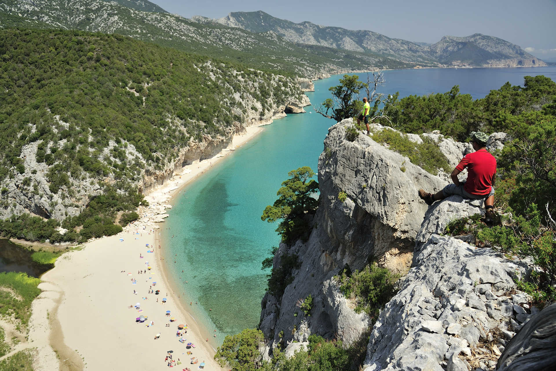
Cala Luna
One of the wonders of the Gulf of Orosei, as well as the symbol of the eastern coast of Sardinia. Cala Luna is located half way between the territories of Baunei and Dorgali and is characterized by the mouth of the Codula di Luna torrent. Sheer rock faces protect and frame the cove, dotted with shady, spacious natural caves that offer shelter from the sun in the hottest months. The golden beach in the centre of the cove is washed by theclear blue, sea.
It is particularly popular with recreational underwater fishing enthusiasts or people who simply want to take a dip in its waters. It is equipped with a bar, a place for dining/refreshments and has shallow waters that makes it easy for children to play in the sea. The beach can be reached via sea, by boat, such as the boats departing from the nearest tourist ports (Cala Gonone, Santa Maria Navarrese and Arbatax). For trekking enthusiasts, the beach can be reached via a difficult trail (suitable for real experts), leaving from Cala Fiuli (Dorgali) or from Baunei. Because of its unusual beauty and wild charm, it was chosen as the setting for the film entitled 'Swept Away' by Lina Wertmuller, with Mariangela Melato and Giancarlo Giannini, an Italian cinema cult movie. It was also the setting for the remake of the film, starring the superstar, Madonna.
All around the bay, are the mountains of the Gulf of Gennargentu NationalPark, with their inaccessible peaks, the land whitened by pure white stones scattered all over the territory and large green valleys offering picturesque trekking trails. Holm oak, strawberry tree and oak woods create a picture-postcard landscape throughout the year, especially when spring and autumn bring with them a kaleidoscope of colours. Further south, along the gulf, in the territory of Baunei, you will find other havens with their unspoilt nature and crystal clear waters: the coves of Biriola, Sisine, Mariolu and Goloritzè,other corners of paradise that will remain in your memory for a long time and all of which can be reached by boat or via exciting trekking trails.
Oasis of su Barone
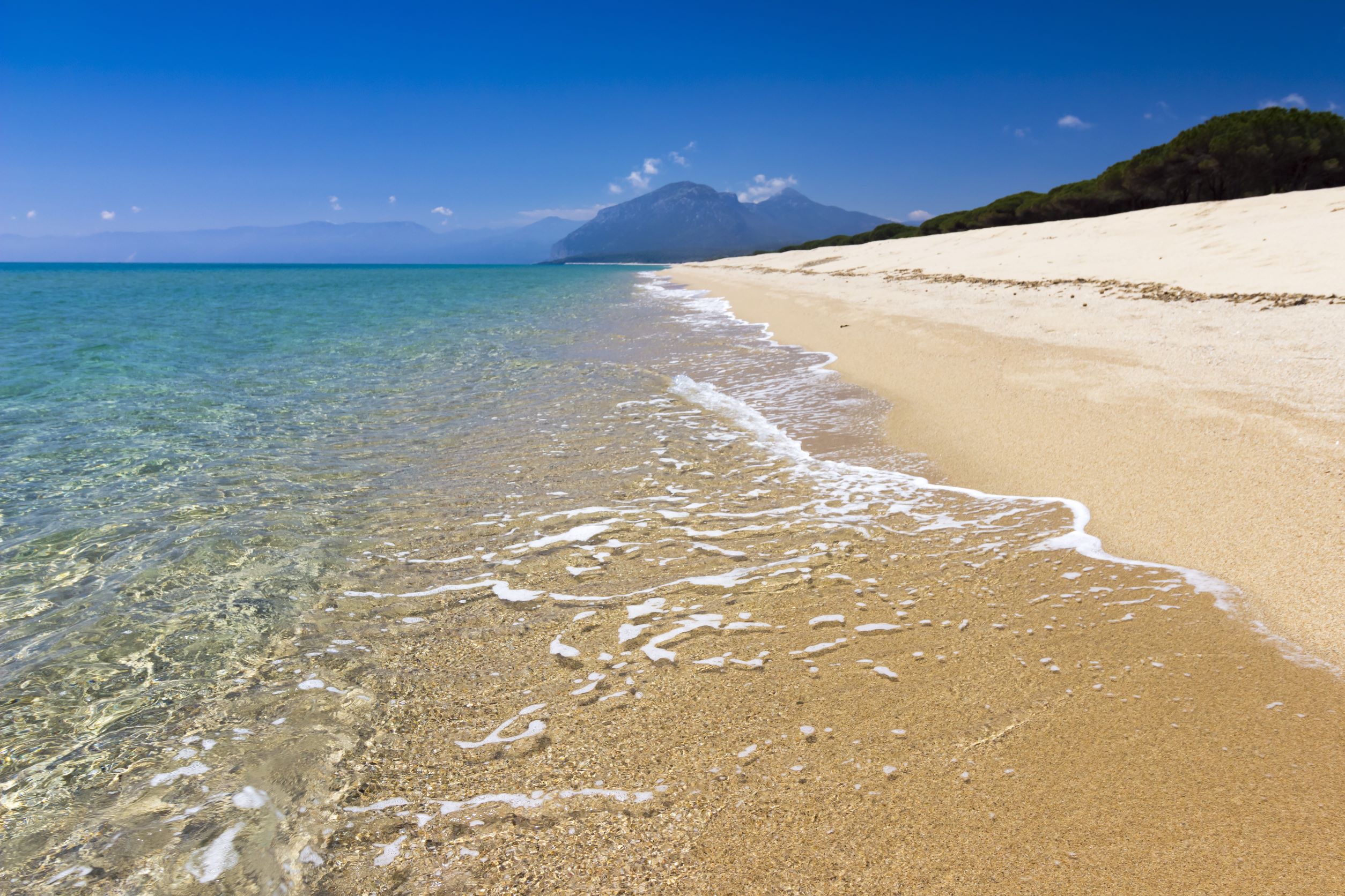
A large sandy expanse of about four kilometres plunges into the glistening sea, with a pine forest running alongside its entire length, close to the sand dunes, separating it from a lagoon area, which is inhabited by rare water birds. The oasis of su Barone, which has recently become the ‘place of the heart’ of FAI - Fondo per l’ambiente italiano (Italian National Trust), extends south of the Marina di Orosei and is one of the longest stretches of the Orosei coastal territory. The beach is part of a large and fascinating territorial compendium, with plant and animal life biodiversity protected as a Site of Community Importance (SCI), which includes the su Petrosu pond behind the sand dunes, and passes through the mouth of the river Cedrino, reaching the neighbouring beach of Osalla. In the large unspoiled oasis, you can book excursions on horseback or you can walk or ride a mountain bike along the marked trails. You can explore the other coves of the gulf on a charter or by renting a rubber dinghy.
The beach has golden, granitic but soft sand with medium grains mixed with shells. The shining sea is transparent, with shimmering shades of blue and emerald green, while the seabed is sandy and the water is deep close to the shore, ideal for wakeboard, windsurfing and kitesurfing enthusiasts, who favour this beach because it is very exposed to the winds. It is also easy to reach, just a few minutes from the town, along ‘Via del mare’ in the direction of the Marina. Two and a half kilometres along the road, you will come to the car park, which is located inside a dense pine forest, perfect for picnics and for some solace in the hottest hours of the day. After walking past a pier, you will come to the long, wide beach that offers ample space to anyone and is a true paradise for those who love relaxing, even in August.
Su Barone is suitable for people who want to enjoy the free beach, although there is no lack of services, along with a beach establishment where you can rent sun loungers and umbrellas, as well as bar-kiosks. It is also popular with families, thanks to an adventure park in the pine forest, which blends harmoniously with the surrounding environment and where children and teenagers can play safely. Behind the pine forest, there is a lake area generated by the Cedrino, including the pond of su Petrosu - Avalè. Grey herons are at home here, along with cormorants, coots, seagulls, moorhens and egrets, as well as others that are here periodically, such as ducks, black-winged stilts and pink flamingos. The salt waters are a nursery for various species of fish (eels, sand steenbras, flathead mullet, gilthead bream, sole, sea bass) and mussels and molluscs are farmed there.
Stazione of art
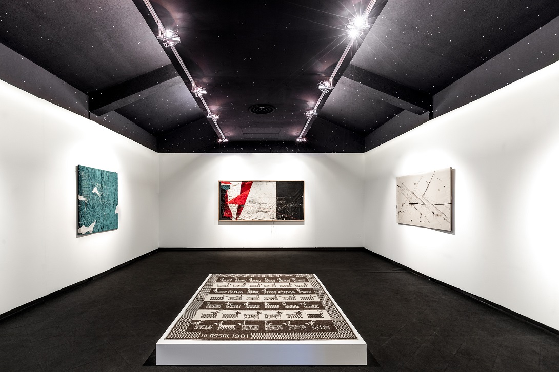
There is a splendid exhibition in the former railway station of Ulassai, a mountain municipality in the province of Ogliastra, where the genius of Maria Lai was born. This is an atypical museum that overlooks a valley surrounded by limestone Buttes, not far from the village, where a large collection (150 works) by the great artist who died in 2013 is kept: ceramics, sewn books, frames, canvasses and terracotta pieces donated to the village by its most illustrious daughter, who drew inspiration from her origins and created an infinity of forms that made her famous throughout the world. Created in 2006, dedicated to her and renamed Station of Art, the museum occupies three renovated buildings, where trains climbed up along the Gairo-Jerzu line until 1956. It is now the point of arrival of the creative journey of an artist and her place of birth, which began with 'Legarsi alla montagna' (1981), when the surrounding mountains and houses of Uassai were united with a sky blue ribbon tens of kilometres long. This and later events make Ulassai an open air museum.
The works are displayed alternately on a thematic basis. The itinerary starts from the building in which the waiting room and the house of the station master were located: on the ground floor, on white walls, the bright colours of the velvets of Astral Geographies stand out, along with the jeans canvas that describes the universe of Earth and Sky and the needles and hanging threads, inserted into the canvasses, inviting a reinterpretation of infinity. The upper floors are dedicated to personalities who had an influence on Maria Lai: Giuseppe Dessì, Salvatore Cambosu and Arturo Martini. You will be fascinated by the sewn book that tells the tale of the distracted god and of the janas who taught the Nuragic women to spin fabrics, the terracotta of Maria Pietra, the Sculpture that breathes and the everyday Stones. The former train depot welcomes you, on the ground floor, with an invitation to the table, symbol of culture as a food for the soul and the mind. On the first floor, in the In sa mat' e s'olia, there is an endlessly tangled brass thread, inspired by Garçia Lorca. In the square, you will find Intertwined Tales, a tribute to Antonio Gramsci.
You can combine the visit to the Station of Art with one to the centre of Ulassai, where you can admire sculptures by Lai and other artists, as well as a trip to the caves of Su Marmuri, which are among the most extensive in Europe, where stalactites and stalagmites are still growing constantly.
Porto Frailis
An enchanting little arch-shaped cove south of capo Bellavista, with fine silvery-gold coloured sand, set between smooth, almost flat granite rocks, on which the shimmering blue transparent waters break, with a play of light created by the sun. Porto Frailis is a beautiful little beach – about 200 metres of sandy shore - just about one kilometre from Arbatax, the port of Tortolì, quiet, protected from the winds and watched over by the tower of San Gemiliano. The crystal-clear sea, the sustainability and adequate services all around have often earned it the Blue Flag recognition by FEE (Foundation for Environmental Education).
The sandy seabed, with some pebbly stretches, gently slopes towards the open sea and, along with the Mediterranean greenery that covers the surrounding promontories, it contributes to the peaceful, relaxing feeling of this little corner of paradise in Ogliastra. There is no shortage of fun for lovers of water sports, including windsurfing and canoeing. On the beach, you can rent beach equipment, pedaloes and jet skis. Nearby, you will find accommodation, including well-equipped hotels and campsites, as well as restaurants and nightclubs.
Porto Frailis is one of the many jewels on the Tortolì coast. The closest beach, on the opposite side of Capo Bellavista, is Cala Moresca, practically inside the town of Arbatax and protected by the famous Rocce Rosse. It too is composed of red porphyry rocks, mixed with granite ones, forming a cluster of homogeneous colours. It owes its name to the raids of Saracen pirates (is morus). Just outside this little town in the Ogliastra area, there is a series of splendid beaches, starting from Lido di Orrì, sixteen kilometres of coastline made up of inlets and small deserted beaches, including Cala Ginepro. Then there is the beach of san Gemiliano. After that, you will find the soft white sand, smooth rocks and shades of emerald green of Cea, over a kilometre long, three quarters of which is in the territory of Tortolì and a quarter in that of Barisardo. There are two sea stacks emerging 300 metres from the shore, twenty metres high: is Scoglius Arrubius, the symbol of Cea, can be reached by swimming or by pedalo.

Isolotto d'Ogliastra
Ancient Arabian coins were found here, as well as a box with a manuscript. According to an ancient legend, the Saracen pirates hid treasure here. In reality, throughout the second half of the 19th century, the little island was a treasure in itself, in the sense that it was a crucial place for sailing and a valid shelter for sailors and fishermen when they were surprised by the stormy sea.
It is commonly called the Isolotto d'Ogliastra (Islet of Ogliastra) and is, in reality, a little archipelago with three main large rocks made of pink granite and red porphyry, as well as various other little rocks just above the water, in front of the beach of Lotzorai, the territory to which it belongs. The largest islet stretches for over 10 hectares and is just over one kilometre from the coast. You will be able to visit it by canoe or pedalo when the sea is calm, or by boat, either in a private boat or on a guided tour by boat, leaving from Tortolì - Arbatax or from Santa Maria Navarrese. These are tourist ports from which you can also set off to discover the famous coves of Ogliastra (Cala Biriola, Cala Goloritzè, Cala Mariolu and Cala Sisine).
Although it is not much more than a rock on the maps, for all nature lovers it is a paradise with a transparent, crystal clear sea, a destination for yachtspeople, who can find shelter in the harbour. In the numerous little coves of the islet, you will see rocks that have become natural sculptures, shaped by the wind and the waves. On the summit, approximately 50 metres high, a statue of the Virgin Mary of Ogliastra has been placed and is the work of sculptor Pinuccio Sciola. From that moment, the islet also became a destination for religious worshippers and pilgrims: the festival of the Virgin Mary, queen of peace, is celebrated here at the end of July.
The hinterland is covered by lush Mediterranean vegetation with its unmistakable fragrances. It is populated by various marine birds: shearwaters, shags, yellow-legged gulls and Audouin's gulls. Its waters, which are deep blue and have a rocky seabed, are the ideal destination for snorkelling enthusiasts. After a day by the sea, on the beach of Lotzorai and the islet, the historical and archaeological tour begins: don't miss your chance to visit the Castello della Medusa (Castle of the Jellyfish), built during the Middle Ages over the ruins of a more ancient Punic building, various domus de Janas, dug out of the rock in the area of Funde ‘e Monti and the not-to-be-missed nuraghe Orzudeni.

Cala Osalla
A spectacular and comfortable holiday destination that looks out onto the northern part of the Gulf of Orosei. Osalla is a delightful cove with a little, unspoilt beach, set in greenery, in the territory of Dorgali, as well as a large beach next to the territory of Orosei, situated at the mouth of the Cedrino river, which forms a pond behind it that is frequented by numerous aquatic birds. They are separated by a little promontory that does not differentiate them very much: both are magnificent, except that the waters in the territory of Orosei are immediately deep, with a shoal 30 metres from the water's edge.
The cove of Osalla is separated from the ‘Spiaggione’ (big beach) of the same name by a rocky spur, which is easy to reach on foot, where a little mooring harbour has been created for tourist boats and fishermen's boats. The sand is quite fine and the seabed is shallow, making it suitable for families and a place in which children can play, but also for snorkelling enthusiasts.
The beach of Osalla is a long (almost five kilometres) stretch of fine, golden sand, protected and delimited by dark reefs, that offers a solitary and unusual appeal. Next to it, there is a lovely pine forest, ideal for relaxing in the afternoon, while the Osala rivulet flows parallel to the beach and can be crossed via small bridges. Its waters are transparent and iridescent blue in colour, because of the play of light created by the reflection of the sun on the seabed. Another play of colour comes from the green of the dense, enchanting Mediterranean scrub that surrounds it. The seabed is a little deeper and is the destination of surfers and divers.
In the area of the coves, there is ample parking, accommodation and places for dining/refreshments, as well as beach equipment rental services. Osalla is easy to get to from Dorgali, passing by the famous grotto of Ispinigoli, which undoubtedly deserves a visitbefore taking a dip, and they are approximately four kilometres from the sea. From Orosei, however, you move southwards, passing through Su Petrosu.

Ziu Martine
White limestone walls frame its sides, creating an unusual contrast of colours with the dark basaltic rocks that emerge. On the shore, the light sand is mixed with smooth black pebbles, in front of an emerald green sea. Ziu Martine is the beach of pleasant contrasts, just over three kilometres from Cala Gonone, a Dorgali fishing village of. Whether travelling by car or on foot: the scenic Viale del Bue Marino offers beautiful views of the Gulf of Orosei. From the road, there is a dirt path through the scrub – where green junipers, myrtles and mastics grow - leading you to a short flight of steps, at the end of which the enchanting beach will appear before your eyes.
The beach stretches for about 300 metres, half of which are occupied by rocky outcrops. The water is crystal clear with a pebbly seabed and it is no coincidence that Ziu Martine is one of the most popular destinations in the gulf for diving and snorkelling, also thanks to the rich and varied marine wildlife that populates the numerous underwater caves hidden among the cliffs. Never excessively crowded, it’s the right place for you if you want to enjoy the sea with total relaxation, but it also offers plenty of options for adventurous experiences: in addition to swimming, sport fishing and diving, you can reach it by sea in a kayak. The jagged rocky ridge protects the beach behind it and, as well as sheltering it from the northwesterly and westerly winds, it is a favourite rock face for free climbing enthusiasts and professionals.
Ziu Martine falls within the National Park of the Gulf of Orosei and Gennargentu, a protected area that extends for 74 thousand hectares and contains numerous natural treasures. Along the coastal stretch as far as Baunei, there are ravines, like the famous Grotte del Bue Marino (Sea Oxen Caves), and wild coves. Cala Fuili is the last beach that can be reached from the scenic road coming from the village of Ziu Martine - and is characterised by shallow waters and extraordinarily transparent waters. Cala Luna has been repeatedly chosen as a film set and, along with Cala Biriola, Cala Mariolu and Cala Goloritzé, it is part of the ‘pearls’ of the Gulf, which can be reached via trekking trails or more easily from the sea. They are characterised by rugged, rocky surroundings and almost unreal colours and crystal clear waters, impossible to forget. Among the attractions in the park’s inland area, the karstic spring of su Gologone is a must, as well as the canyon of su Gorropu, the natural monuments of Perda ‘e Liana, Pedra Longa and su Texile, the Nuragic village of Tiscali and the elevations and forests of the Gennargentu.
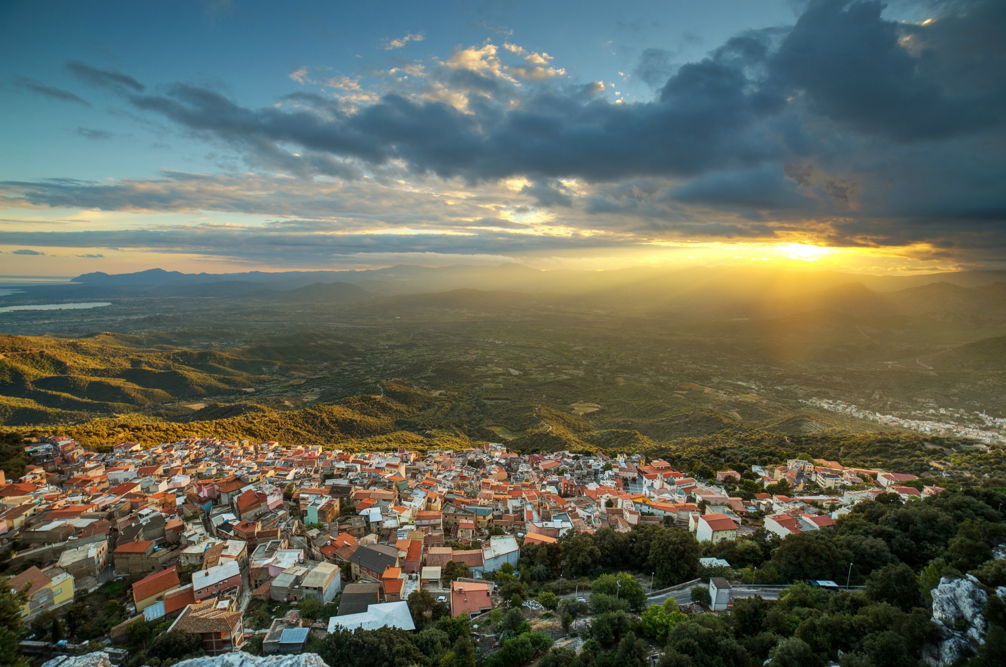
Baunei
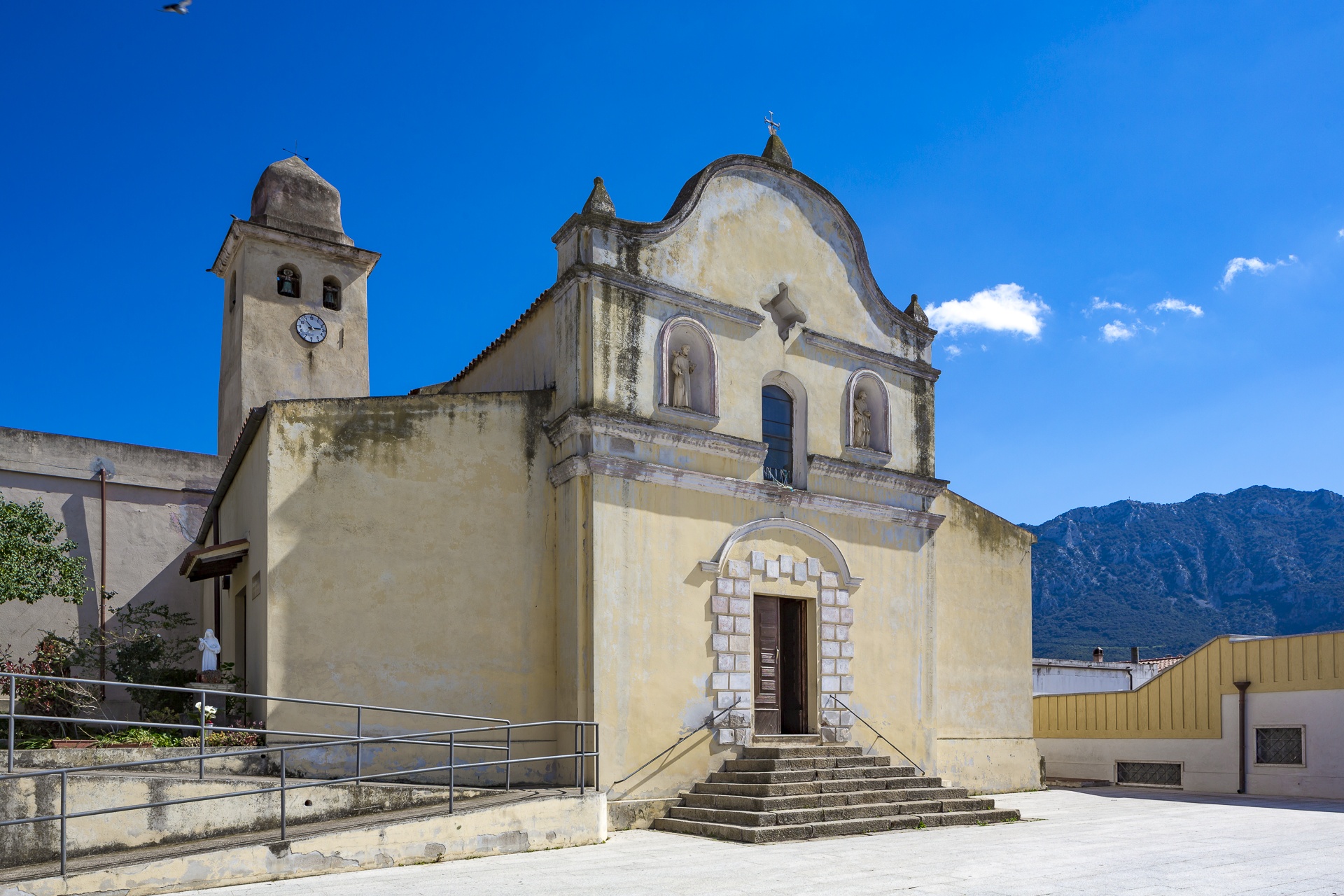
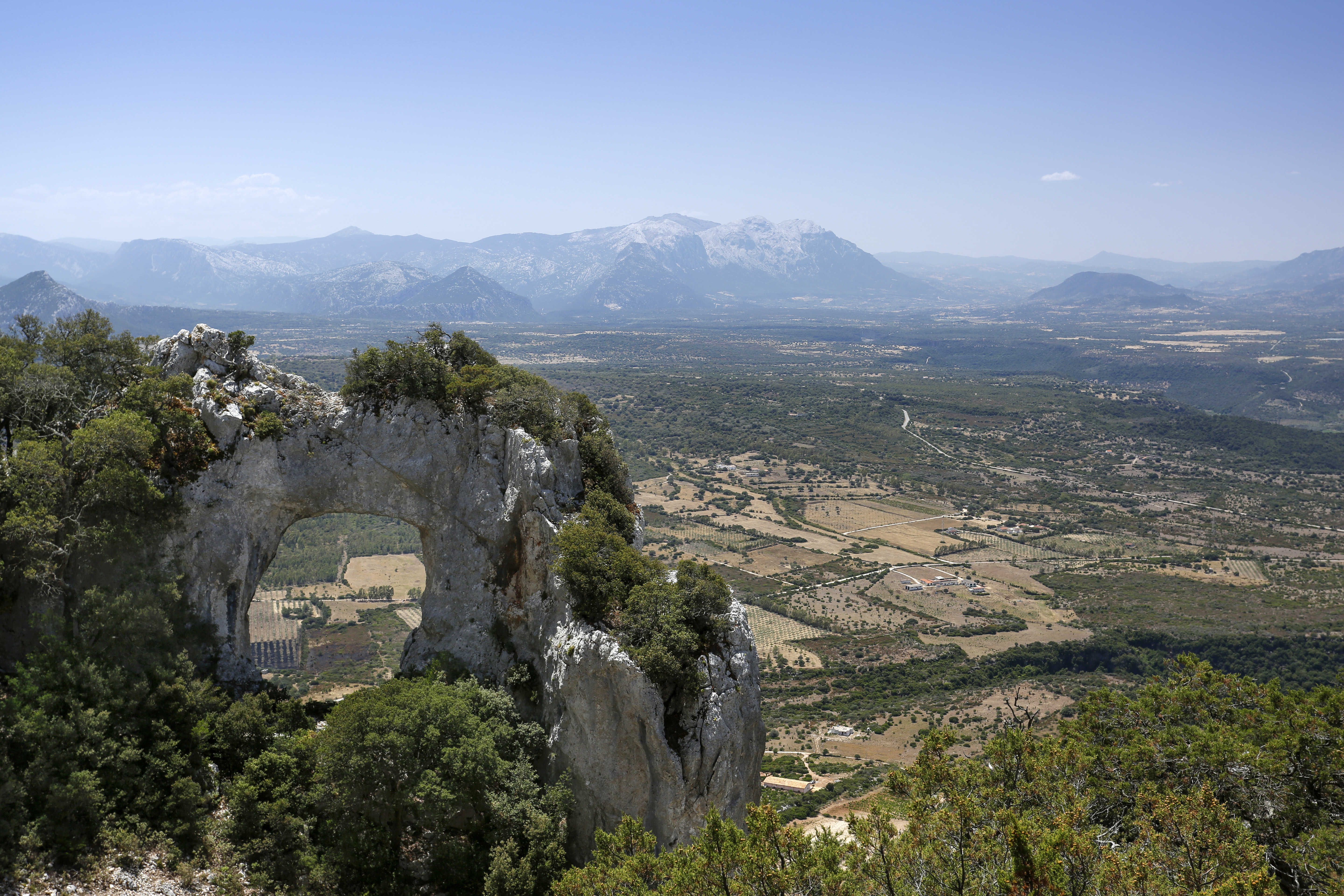
A village “clinging to a sheer slope on the limestone ridge of Monte Santo - as the historian Vittorio Angius wrote - isolated in the isolated Ogliastra”. The panoramic position overlooking the valley below, makes the folk tale about its founding more credible: a goatherd created Baunei on the rocky elevation, at an altitude of almost 500 metres, to escape from the Arabs who were trying to invade in 1015. In the centre of the ‘steep’ village, which now has a population of three thousand 600 inhabitants, the Nicola di Bari parish church stands out, with its seventeenth century structure that was renovated in the 20th century. The Supramonte mountain range of Baunei, the home of hiking, extends around the village, with trekking trails that stretch from the mountains to the sea and its vertical rock faces are a rock climbing paradise. In particular, a gully leads to the natural monument, Pedra Longa, a pointed pinnacle 128 metres high, overlooking the sea. Eight kilometres of spectacular hairpin bends take you from the village to the heart of the big, silent Golgo plateau, covered with a dark, basaltic lava flow standing out against the whitish colour of the surrounding limestone rocks. From up there, at an altitude of 630 metres, you will enjoy a breathtaking view that stretches from Gennargentu to the Gulf of Orosei. Here, a launching pad has been set up for paragliding. The plateau is famous for su Sterru, another natural monument, the deepest single span karst chasm in Europe. The chasm (270 metres deep) is dense with mysterious legends: it was said to have been a snake’s lair, the threat of which was thwarted by the construction of the nearby Church of San Pietro, celebrated at the end of June, along with the feast of goat meat.
Limestone cliffs and bastions overlooking the deep waters with iridescent colours, broken here and there by pebbled coves and crossed by codule and canyons that reach the sea forming soft white sandy beaches. These are the distinctive features of the Baunei coastline, which extends for 40 kilometres along the southern part of the gulf, one of the wildest and most evocative stretches in the Mediterranean. The district of Santa Maria Navarrese is located on the coast, facing the islet of Ogliastra. A legend links the coastal district to a Spanish princess, who had been driven out or who had fled from Navarra: in 1052, the young woman took refuge from a storm in a bay, where, in the shade of some olive trees thousands of years old, she had a little white church built, to express her thanks for being safe from danger. Around it, an enchanting little village arose by the sea and today it is one of the most popular tourist centres along the eastern coast. From its modern port, you can get to the beaches that symbolize Ogliastra. The transparent, turquoise waters of Cala Goloritzè, a national monument, flow from underwater springs, between marble rocks shaped by time and lush vegetation. A majestic pinnacle stands above it and it is the home of climbing enthusiasts. You can also get to Cala Biriola along a long trekking trail: it opens up at the end of a holm oak and juniper forest. If you choose to use a boat or a dinghy, before you get there, take a dip in the Piscine di Venere. Cala Mariolu and its ‘little sister’ Cala dei Gabbiani are protected by a 500-metre cliff and are striking as a result of their blue, emerald green and azure waters and round pink and white pebbles, mixed with sand, that resemble snowflakes. Cala Sisine appears at the end of an ancient riverbed covered in centuries-old trees: this is one of the most beautiful sea resorts and has a unique mountain view. Lastly, Cala Luna is like the setting for a film – halfway between the territory of Dorgali – with its limestone craters, it looks as if the sea is inside an ampoule. The Supramonte also conceals an underground world, marked by the patient work of the water, with deep tunnels and unusual stalactites and stalagmites, looking out onto the sea. These are places where time stood still 800,000 years ago, like Grotta del Fico and another miracle of nature, Grotta del Miracolo. Inside it, the reason for its name becomes clear. The beautiful natural heritage is the habitat of rare species and an open-air archaeological museum. At Cala Luna, in the su Marinaiu cave, traces of the first settlements dating back to the Eneolithic period have been found. The most significant evidence is of the Nuragic civilization, especially in the plateaus of Margine and Golgo, where famous bronzes were discovered and are on display at the Archaeological Museum of Cagliari.
Irgoli
Nestled in the Cedrino valley, surrounded by a landscape of gently rolling verdant hills cut through by streams and brooks, with a height of 860 m above sea level at the granite summit of monte Senes. Irgoli counts over 2,000 inhabitants and is known for its fine cured meats and quality cheese, for its craftsmanship with wood, iron and ceramics. The streets of town are decorated with wall paintings, murales, that tell of rural life and passion for music. Since 1986, every August they hold the festival dell’organetto (accordion festival), an international ethnic music event, and all year round a collection of some 120 bellow instruments are on display. The little parish church of San Nicola has, since 1500, housed a reliquary containing a thorn from the crown of Jesus. It is around this relic that Easter Week celebrations revolve. Several of the country churches were built on Nuragic Era remains: Sant’Antioco over a nuraghe, and the XIII century Santu Miali over a giant tomb, whose great stone slab was put to use as the main altar.
Part of Monte Albo, known as the Sardinian Dolomites for its steep white walls, gorges and grottoes – which served as prehistoric dwellings - belongs to Irgoli. Hiking trails lead to the top through woods that thin out all the way to the white peak, sos Aspros. The mountain is a fauna oasis and home to the European mouflon, as well as a hunting ground for the Royal Eagle. Along the trail you’ll come across sos pinnettos, circular stone and wood huts used by shepherds. Don’t miss the chance to walk in the centuries-old oak woods of Talachè. Nearby, on the slope of Mt Senes, is the Janna ‘e Pruna complex that dates to the late Bronze and early Iron Age (XII-IX century BCE). You’ll see a temple with a sub-rectangular atrium and circular cell, perhaps originally covered by a fake dome. Around it is a temenos (sacred enclosure) which is itself surrounded by a stone wall. 200 metres further on, at 500 m above sea level, is a sacred spring that dates to the same era, s’Untana ‘e su Zigante, an architectural gem built on a basalt blocks, a temple of water worship. The green mantle of Senes also includes the su Notante nuraghe and springs, dating to the Late Bronze Age (XII-X BCE). A portion of the façade (a facing used on the rocks) and the catchment well, complete with entrance, roof and basin still exist. There is even a stretch of a sturdy terracing wall. In nearby Ortola are the remains of the Tutturu nuraghe, rocks in natural, human and animal shapes, like sa Conca ‘e Caddu (horse head), and traces from the late Neolithic: domu de Janas at Conca ‘e mortu, a skull-shaped granite structure with two connecting rooms. The votive offerings of Janna ‘e Pruna and su Notante, utensils, vases, bricks, fusion forms, fusaroles, loom weights, necklaces, brooches and bracelets, a pintadera, a little basalt model of a nuraghe and items that came from other sites around Irgoli are all on display at the Antiquarium, in what used to be city hall.
Galtellì
Along the shores of the Cedrino river, Galtellì sits on a spectacular high plain at the feet of Tuttavista, on top of which stands a majestic bronze statue of Christ, the destination of pilgrimages who follow a path that climbs up the side of the mountain. The statue is a reproduction of the miraculous wooden cross that is housed in the church of the santissimo Crocifisso (Holy Cruxifix), built in Gothic style in the XVI century to replace the XIV century church of Santa Maria delle Torri that was too small to accommodate all the faithful flocking to Christ. Pilgrims from all over Europe come here. The history of the town, a bishopric until 1495, is marked by religious devotion. You will walk along paved streets lined with stone houses, home to a population (2,500 inhabitants) that shares a powerful and heartfelt religious devotion: there are five churches in a single square kilometre. Next to the Santissimo Crocifisso you’ll find the medieval Church of santa Croce, and less than 100 metres further along are the churches of the Beata Vergine Assunta and of San Francesco, both from the XVII century.
Inside the cemetery walls is the complex of what was once the Cathedral of San Pietro, home to a cycle of frescoes from the XIII century depicting scenes from the Old and New Testament. There are three church-related buildings: a high bell tower, the unfinished late XI century cathedral and the Romanesque church of San Pietro, enlarged after work on the other church had been abandoned. The town becomes lively especially during Holy Week, with heart wrenching chants and centuries old liturgies. The festivities surrounding the Holy Cross in early May, when devotion expresses itself through folklore and shows, and the bonfires in celebration of Sant’Antonio Abate on 17 January are not to be missed.
Galtellì has been awarded the Touring Club Italiano’s orange flag rating for excellence. The streets of the old town centre, its traditions and sensations inspired the author Grazia Deledda when she set her book Canne al Vento in Galte. The connection the town feels with the Nobel Prize author is underscored by the Deleddiano Literary Park, an itinerary along the places she mentions in her book. Aside from being a spiritual guide, it was once a centre of power as symbolized by the castello di Pontes, a fortress built in the late XI century and eventually conquered by the Aragonese. The XVIII century Casa Marras house was once an aristocratic residence that has now been transformed into an ethnographic museum featuring some 1800 objects and represents the collective memory of this town. You can also visit the Malicas park, an oasis of green that surrounds an early XX century castle, and some stone domus de Janas chambers, proof of man’s presence here as far back as the Neolithic Era. The various nuraghe date to the 2nd millennium BCE and include su Gardu. From culture to nature: Tuttavista hill is a popular hiking zone and separates the town from the sea. It has sheer walls equipped for rock climbing. From the top you will see the golfo di Orosei and, when ascending, the Preta Istampata, a boulder with a huge hole, a window over a valley covered in woods.