
Montarbu
One of the most evocative Sardinian forests, Montarbu occupies 2800 hectares of territory, a small part of which is in Ussassai and most of which is in Seui, to the east of the town located ten kilometres away. The state-owned forest stands out on the slopes of Monte Arbu and Tonneri. To the north, the Flumendosa river separates it from Gennargentu. In the centre, there is a plateau, at a height of approximately one thousand metres, with vertical walls and valleys furrowed by streams, among which you will be impressed by the rivulet of Rio Ermoliosu, with its colours and numerous springs that sometimes form waterfalls in the greenery, like that of Serra Middai. The summit is Punta Margiani Pubusa: it is at an altitude of over 1300 metres and offers spectacular views. Descending from the peak, after having come across the spectacular 'ponor' of Su Stampu and Su Turrunu, you will encounter S'arcu and Pirastu Trottu from which you will reach the limestone 'butte' of Perda Liana, a unique natural monument.
The coolest slopes are dominated by holm oaks. You will see some monumental ones: the largest is S'Ilixi 'e Canali. Evergreen shrubs and conifers grow near the summits, as well as examples of yew and holly. Other trees there include maple, hornbeam, ash, alder, poplar, willow and a few chestnut and beech trees. Further down, there is a strip of Mediterranean scrub: strawberry trees, heather, juniper and mastic. The lush vegetation will enshroud you with its fragrances while you take a relaxing stroll, accompanied by the sound of the rushing water of the streams. Around the trails, deer, wild boars, weasels, dormice, martens, squirrels and foxes dwell. The forest has been repopulated with fallow deer and mouflons. The golden eagle, the goshawk, the cinereous vulture, the peregrine falcon, the griffon vulture, the kite, the buzzard and the Eurasian sparrowhawk fly overhead. Not surprisingly, it has been a wildlife oasis since 1980.
In an ideal location for trekking and bicycle excursions, you can go on organized visits and lunches and stay in bungalows and campsites. Inside the complex, there is a museum of flora and fauna, where you can also admire archaeological finds: these come from the site of S'Orgioloniga, in which there is a sacred font, and also from nuraghi, among which Analù. You will also be able to visit Montarbu in an alternative way, on board the Trenino Verde tourist train.
Cala Biriola
In the territory of Baunei, halfway between other wonderful havens on the Ogliastra coast, like Cala Goloritzé and Cala Luna, and near Grotta del Fico and Cala Sisine, liesCala Biriola. This delightful little beach of round, white pebbles, protected by the limestone cliffs along an area of over two kilometres, appears at the end of the charming thicket of the same name, consisting of centuries-old holm oaks, junipers clinging to the rocks and Mediterranean scrub. It is framed by a rocky arch, which is level with the water, with the waves breaking against it and completing the unforgettable tableau vivant. The extremely transparent water, which is full of fish, make it suitable for scuba diving or swimming with a mask and snorkel.
You will reach Cala Biriola via a long and challenging trekking trail through the mountains of Supramonte, setting off from the Golgo of Baunei, with several uphill climbing stretches that require the assistance of expert guides, adequate equipment and an abundant water supply. The trail runs along the cliff, offering thrilling views of the sea below. Here, shepherds and coal merchants, the protagonists of the main activities of the past, left behind numerous traces: ladders, log footbridges, iron runners to facilitate the passage of people and animals to the sea and the loading of coal onto the barges. Otherwise you can get there on a private boat or by using those departing from the ports of Arbatax, Cala Gonone and Santa Maria Navarrese. If you opt for a boat or a dinghy, just before your arrival, you will not be able to resist diving into the Piscine di Venere, a body of water with bright colours that change from turquoise to emerald green and from sky-blue to deep blue. These are real natural pools.

Rio 'e Forru e Pirincanes
In the heart of the Gennargentu park, in the most authentic and green part of Sardinia, the most inaccessible and wild treasures of Arzana stand out: two natural jewels that plunge into the bowels of the earth - the Pirincanes gorge and the Rio 'e Forru waterfall. The impressive granite rock with its pinkish hue was excavated over the millennia by the torrent, which descends from the aquifers of the mountain and runs through a valley where it has left its mark over time. The Pirincanes gorge is around 700 high, in the foothills of the BrunciCuxinadorgiu, and forms open air pools of crystal clear water known as the "giants' cauldrons". They are surrounded by waterfalls, which foam and fill the surroundings with natural noise, crashing from fall to fall, the highest of which is 15 metres. Here native species, almost extinct in the other Sardinian torrents, flourish, such as the Sardinian trout and the Sardinian newt, with its distinctive green and brown camouflage.
The eastern slope of the Gennargentu massif, in the territory of Arzana and of Villagrande Strisaili, offers unusual landscapes such as the village of Villanova Strisaili, which stretches along the banks of Lake Flumendosa, among the fairy-tale frame of the mountains. You can see these scenes along itineraries with breath-taking panoramas over dramatic rockfaces, woods, Mediterranean brush, junipers and broom, rare animals such as mouflons and royal eagles, and the crashing of water that overcomes all obstacles. A path leads up to the waterfalls towards Monte Oreddu, continuing after about an hour's walk to Arcusu Stampu and Bruncu Margiani Iola. From here it leads to the point where the Rio 'e Forru has excavated the Pirincanes gorge. You can admire them from above, on a natural balcony. You'll need a love of trekking, good equipment - perhaps including a dinghy - and supplies of food and water: the trip is recommended during the summer months, not in the periods when the torrent is at its fullest.
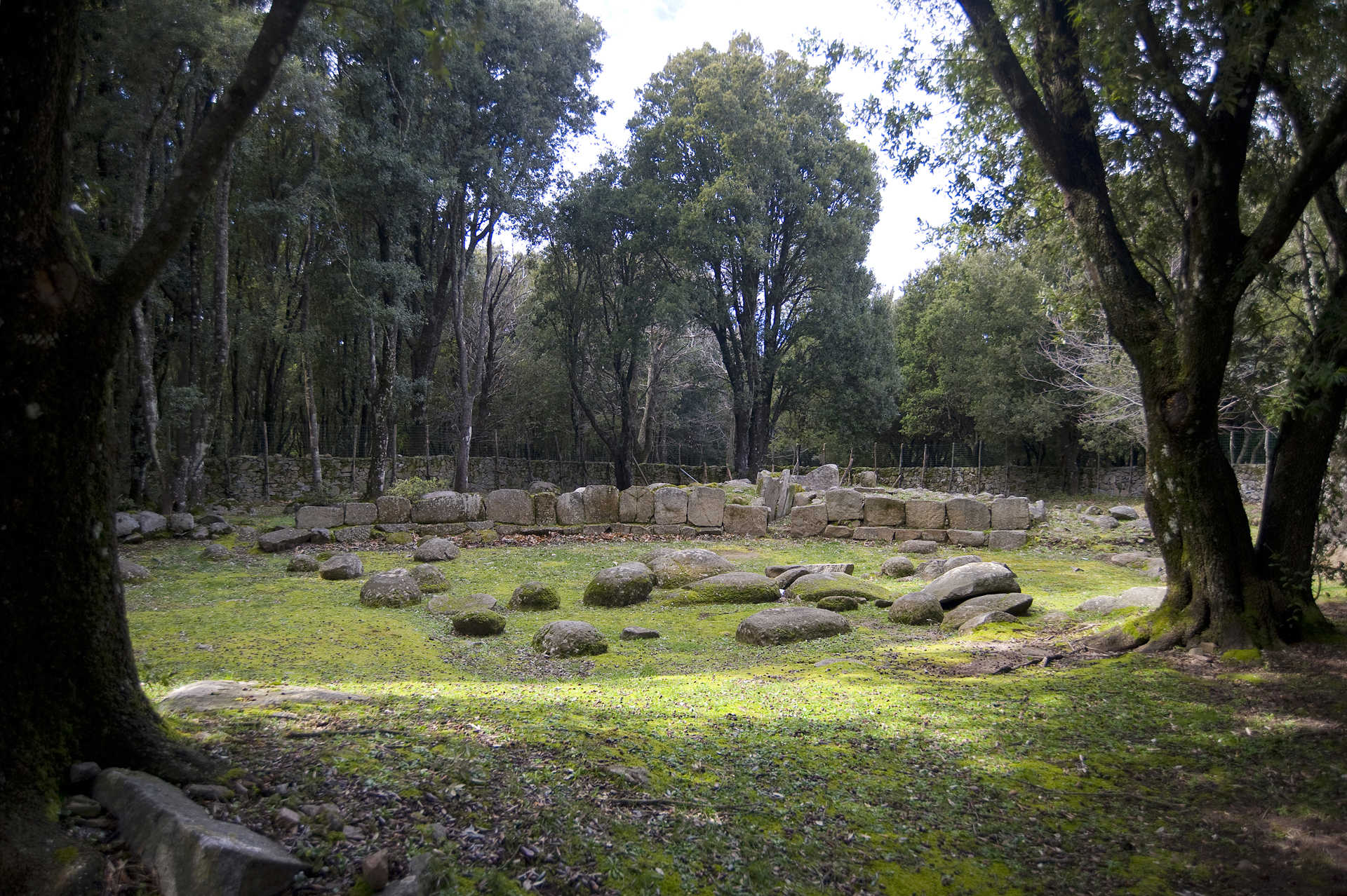
S'Arcu 'e Is Forros
A people who lived in symbiosis with nature, who expressed their spirituality venerating water, who constantly improved their skills in crafting stone and metals. Between Ogliastra and Barbagia, in the domain of Villagrande Strisaili, the riu Pira ‘e Onni valley is home to an intricate and fascinating archaeological complex many of whose characteristics can be ascribed to the Nuragic civilisation. It is called s’Arcu 'e is Forros, a symbol of the evolution of cultural characteristics from the Bronze to the Iron ages, and of relationships with civilisations far beyond Sardinia.
It’s a village/sanctuary built over a previous settlement of huts on a plot of land bordered by two streams. The sacred and residential areas include three temples, two areas with huts and, not far away, a three-lobed nuraghe.
The main temple, megaron-style, is 17 metres long, made of granite and schist, and has four rooms. Around it is a temenos, that is, a sacred enclosure with benches carved into the base of the perimeter wall that were likely used as seats for the faithful or as a depository for their offerings. The stone plinth along the inner walls was probably used for the same purpose. Along the western side is a narrow channel that leads to a small rectangular opening, probably used for the runoff of ritual water. The second temple is very similar, including the temenos, only smaller. It had an altar made of square blocks of different colours and materials, basalt and trachyte, neither of which is local and therefore most likely imported for the purpose. Two high relief protomes of rams decorated the frontal conches, while higher up another four conches, carved to resemble Nuragic towers, supported the sacred fire. Most of the altar has been removed and is now housed at the Archaeology Museum of Nuoro.
The residential and artisanal parts of the complex were comprised of two areas, groupings of buildings set around a circular courtyard with a fire pit at the centre. In the larger of these two “neighbourhoods,” aside from the houses, were also kilns to melt lead and recover metal from the votive offerings. The two circular structures you’ll find near the first temple were probably also ovens, small towers with openings at the base. These structures, to which we must add a third temple with a hearth, are what make s’Arcu 'e is Forros the most important Nuragic metal working centre found in Sardinia up until now. They bear witness to the intimate connection between sacredness and technology: the metal was used to make votive offerings that were then kept in the temple. But not all of the items found in the area were locally produced. Many priceless finds – metal and other – came from Etruria, Greece and the Near East, proof of the intensity of contact and trade with other Mediterranean peoples.
Serra Orrios
It stands on the plateau of Gollei, in the territory of Dorgali, about ten kilometres from the town, surrounded by rugged hills, millennial olive trees and Mediterranean vegetation. Serra Orrios is one of the best preserved nuragic complexes: here, you can journey through time to a village-sanctuary, built entirely of basalt blocks, representing a purposefully designed proto-urban settlement in terms of size and architectural structure.
You can take a careful look at the well-preserved civil and cultural buildings of the nuragic age. The village consists of a hundred circular huts, built with a base of rows of stones and originally covered with branches. They are simple, or divided into different rooms - also to keep the animals, typical of a society dedicated to agriculture and breeding - overlooking a single courtyard with a well. Niches or closets have been created in the walls. The floors are in stone slabs, cobblestones or simple beaten earth. At the centre was a circular hearth, bordered by stones. Clay, and perhaps cork, was used to waterproof the buildings. The houses are grouped into three blocks, connected by small streets and squares. 'Hut 49' stands out, isolated, and may have been the 'meeting hut', characterized by a curvilinear layout and equipped with a bench-seat and an entrance vestibule.
The village-sanctuary, as well as two megalithic tombs, has two sacred areas, each with a megaron temple, a cult building typical of the Mycenaean civilization, which presupposes influences from the Aegean. The two small temples, perhaps dedicated to the water cult, have a rectangular layout equipped with a fence, each with an antechamber and a longitudinal cell, bordered by a bench-seat. One of the two areas is set apart from the town by a large circular enclosure; the other, with a well-preserved temple, is located inside the village, separated by a rectangular sacred enclosure.
The millenary life of the village of Serra Orrios began in the late Bronze Age (16th century BC) and ended in the Iron Age (9th to 6th century BC), and was centred around a market place and religious activities. Its most intense period of settlement was between the recent and final Bronze Age, as shown by numerous ceramic artefacts - cylindrical collared rings, bowls and decorated jugs - found in the excavations and preserved in the archaeological museum of Dorgali. These are now on display in the room dedicated to the nuragic civilization, together with frame weights, spindles and spools that demonstrate spinning and weaving activities, and clay stoves, drawers, smoothing stones, pestles, mills and casting matrices that testify an intense productive activity. Metal items found also include chisels, foundry springs, daggers, axes and ornaments (pins, bracelets, earrings, etc.).
From Serra Orrios you can easily reach other interesting nuragic settlements: the nearest are the Oveni and Purgatoriu nuraghes and the Giants' tombs of Biristeddi. The territory of Dorgali, one of the largest of the island (225 square kilometres), inhabited since the Paleolithic, is dotted with more than 200 Bronze Age sites: 45 nuraghes, one hundred settlements and about forty Giants' tombs, among which the most famous is s'Ena e Thomes, six kilometres from Serra Orrios, and a symbol of the nuragic age with its almost four metre-high stele. Among the villages it is impossible not to visit Tiscali, half in the territory of Oliena, which was a pre-nuragic site and later settled by indigenous communities (civitates Barbarie) open to traffic with the Italian peninsula. Regarding the 'towers', the Arvu and Mannu nuraghes stand out, overlooking Cala Fuili, and are both examples of reuse in Roman times. Around the Mannu nuraghe a Roman settlement spread out over two hectares, remaining active until the late imperial age. Some of the most significant pre-nuragic remains, dating back to the Neolithic, include 55 domus de Janas, among which those of Marras, Pirischè and Campu Marinu, as well as the dolmen of Motorra.
Archaeological park of Seleni wood
On the granite plateau of Selene, a thousand meters above sea level in the deepest part of Ogliastra, the land of longevity, in the midst of a dense wood of holm oaks mixed with chestnuts, oaks, poplars and Mediterranean scrub, is a striking emblem of Nuragic civilisation. The archaeological complex, dating back to a period between the middle and late Bronze Age, is located about six kilometres from the town of Lanusei, in a beautiful environmental setting to visit on foot or by bike, travelling along picturesque paths. The site consists of the Nuraghe Gennacili, surrounded by an agglomeration of around 200 huts and defensive walls and two Tombs of Giants, about half a kilometre from a residential area and from two sacred springs.
Of the Nuraghe, built on a rocky outcrop that sometimes takes on the role of masonry, only the base remains. The sepulchres, constructed in local granite, have a ‘canonical’ layout: an apsidal body, covered corridor and architectural elevation that opens in a hemicycle (exedra). Of Tomb I, the smallest and with a centred stele, the profile can be made out, delimited by a residual row of stone blocks. The semi-circular exedra, fitted with a seat-bench, consists of orthostats worked into the exposed face. Immediately after the entrance, a small corridor separates the ritual and sepulchral areas. The funerary chamber, originally featuring a stele-door, is of a tunnel type, about seven metres long, built with orthostatic slabs installed edge-out, inclined inwards. The finds date back to the 15th century BC. Tomb II, located 80 metres from Tomb I (and the ‘youngest’ by about a century), is 'in rows' and stands on a slight rocky relief. The profile of the layout can be seen, extending 12 metres in length and five in width. The exedra consists of square rows of stones arranged in a structured way, whilst the corridor is composed of finely-worked blocks of granite, projecting inwards as of the third row. Here, the ritual of incubation was practiced. Latin writings reveal that the Nuragic people slept near the tombs of loved ones to meet them in their sleep. Excavations have revealed a block of truncated pyramid shape bearing three holes - this was the ashlar that once crowned the top of the exedra, where three small baetylus were inserted, symbols of the propitiatory fertility divinity. The finds of the Tomb relate to the recent and late Bronze Age (14th-12th BC) - a number of small bronzes can be admired in the National Archaeological Museum of Cagliari. Near the park of the beautiful Seleni forest (in Ogliastra), equipped with picnic areas, you can also visit the astronomical observatory on Monte Armidda.
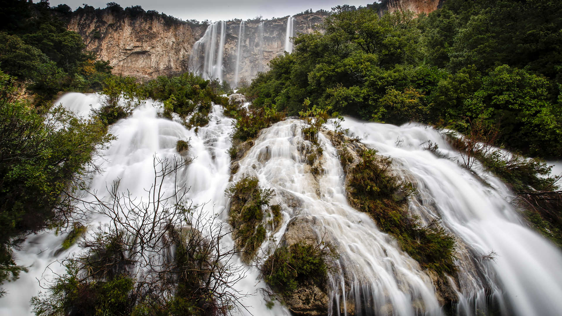
Lequarci e Lecorci
Smooth, vertical walls, covered by holm oaks and filled with Mediterranean fragrances, rise to reach heights of a thousand metres. The Buttes or 'Tacchi' (literally meaning Heels) owe their name to their pointed shape, like the heel of a shoe and characterize the inland landscape of Ogliastra, particularly that of Ulassai. It is a territory rich in underground waters: from the limestone elevations with gushing springs and streams that, during periods of floods, are the origin of evocative waterfalls. Those of Lecorci, half a kilometre from the inhabited area, emerge at the foot of ataccu, not far beneath the cave of su Marmuri, the largest on the Island. The path of the waters continues on downstream until it reaches, after three kilometres, the waters of Lequarci, the other waterfalls of Ulassai, the most impressive in Sardinia.
The waters of the river of the same name, coming from the plateau of Baulassa and Martalaussai, descend down various rivulets from a limestone amphitheatre-style cliff, making a jump of nearly a hundred metres, with a width that reaches 70 metres. Then, they flow, gushing, for another height difference of 75 metres before spilling out into a myriad of little lakes. They are seven kilometres from the village, in the locality of Santa Barbara, where a there is a monumental forest. In the vicinity, you can also visit a church that has Byzantine-Romanesque architecture.
On your nature itinerary, a green canyon awaits you and is several tens of kilometres long, accompanied by the flowing water. You can go up the Rio Lequarci rivulet, to reach the top of the waterfall, surrounded by lush vegetation. Otherwise, there are dozens of other trails that you can take, between the karst rocks. Ulassai, located at a height of over 700 metres, is surrounded by a dolomitic landscape and it is a haven for trekkers and free climbers: thanks to 200 roads that have been marked out and are piton-equipped. The caves are one of its distinctive features: as well as the famous Su Marmuri - nearly a kilometre long - don't miss those of Is Lianas. All around, you will find endless signs of the prehistoric era: the megalithic village of Seddorrulu (3rd millennium BC) and numerous nuraghi, among which Trucculu, Ibbe de su Accili and Pranu (2nd-1st millennium BC) that are perfectly preserved. The village of Ulassai is a treasure chest of culture and traditions and was the birthplace of the 20th century artist Maria Lai: just outside the village, there is the Stazione dell'Arte museum, honouring her multi-faceted genius.

Sos Dorroles
Its beach is orange and pink in colour, the result of the spectacular wall of limestone scree around it - there are no other cases like this on the Island - and the surface layer of pink grains from sand replenishment. The sea that opens up before the beach is crystal clear, reflecting shades of turquoise and emerald green, while Mediterranean greenery covers the rocky ‘belt’, adding a further touch of colour to the landscape. Sos Dorroles is an ‘unusual’ beach on the coast of Cala Gonone, a coastal village in the municipality of Dorgali that stands out almost in the centre of the Gulf of Orosei. The seabed at the cove slopes gently out to sea and is particularly popular with underwater fishing and snorkelling enthusiasts thanks to its transparent waters and rich fish fauna.
The southernmost stretch of the beach is equipped to welcome our four-legged friends. This is the dog beach of s’Abba meica (medical water), a name that goes back to the presence of a spring, centuries before, that was believed to have healing properties. To the north, sos Dorroles blends seamlessly into the beach of Palmasera, the largest ‘Gononese’ stretch of seaside, which stands out for its numerous services - refreshment areas and beach equipment rentals - but the coastal characteristics are similar: the sand has reddish-pink grains mixed with pebbles and stones, with a transparent sea reflecting shades of green and turquoise.
Sos Dorroles is located about a kilometre from Cala Gonone. You can reach it by making a detour along the scenic Viale Bue Marino, which leads from the town to the coves south of the village along the coast. After three kilometres, you will find the beach of Ziu Martine, surrounded by white limestone walls and bushes of Mediterranean scrub and characterised by dark basalt rocks emerging from the water and black pebbles mixed with the light sand. At the end of the road, a flight of steps inside a thicket will lead you to the enchanting Cala Fuili. The white sand contrasts with rocks emerging from the water and a shimmering green and blue sea. The rock faces surrounding the two wild coves are a destination for free climbing enthusiasts.
In the surrounding area you can also go on a journey back in time, to the Nuragic age, visiting the single-tower nuraghe Mannu, built with large vulcanite and basalt rocks on the top of a promontory, 200 metres above the sea and a ‘lookout’ over the entire gulf.
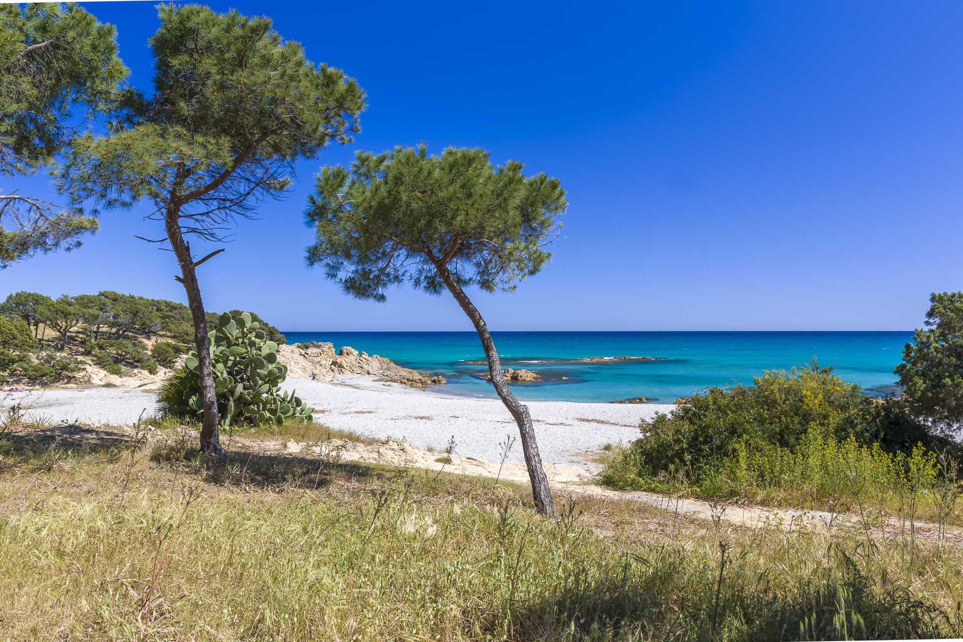
Cala Liberotto
The Orosei Gulf is an endless source of awe. In every little bay, in every beach, you will find yourself wanting to dive in a triumph of nature and beauty. As in Cala Liberotto, about 14 kilometres from the centre of Orosei: an emerald bay with a bottom of thick golden sand, embraced by light rocks. Not far from the shore, three large rocks, easy to access thanks to the shallow bottom, rise from the water to add an exotic touch to the bay. Behind, the sos Alinos pond, surrounded by reeds and agaves, the perfect shelter for the water birds that have chosen this area to make their nests. In the surrounding Mediterranean vegetation, the summer reds and rounded shapes of prickly pears appear, together with dwarf palm trees and myrtle bushes that fill the beaches with delicious scents.
The particular shape of this bay makes it a rich place for trekking paths. Prior to reaching the elevation that separates it from Cala Ginepro, another Orosei wonder made of sandy dunes pockmarked with Mediterranean scrubs and a sea of ever-changing colours, you must face a relaxing walk of a few hundred metres along a beach lined with a thick pine grove. You can get as far as the small and lovely beaches of sas Linnas Siccas and sa Curcurica.
Cala Liberotto, also buffered by the wind, in the summer months is the ideal destination for lovers of underwater fishing, while in the winter it provides surfers with plenty of excitement. It is accessible to disabled people, has a parking area, restaurants and rental of beach equipment. Around the beach you can find restaurants, hotels and camping areas. The whole area is as beautiful during the day as it is magical at night, with its intense nightlife. The vast coastal territory of Orosei is spectacular and offers others gems as well: to the south, the wide and long beach of su Petrosu, with golden sand and wild charm, and la Marina, with more than five kilometres of beautiful sand, whose segments are named su Barone, Isporoddai and Osalla. To the north, Fuile ‘e Mare, beloved by aficionados of water sports and scuba diving, and Mattanosa, with its white and pink sand, lined with Mediterranean scrubs and gently deepening bottom. Finally, in the border with the territory of Siniscola, you will find the protected oasis of Bidderosa, a natural paradise with very few rivals, not only in Sardinia.
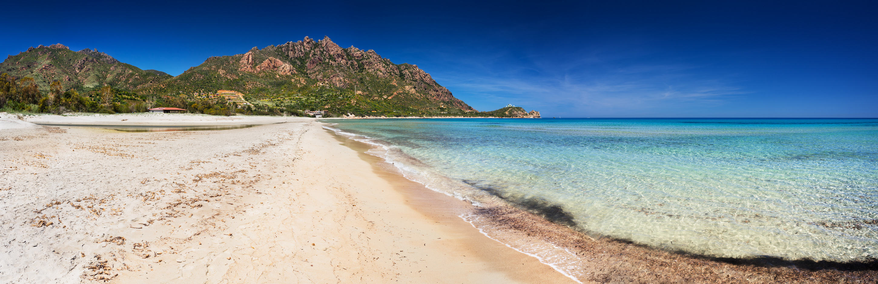
Marina di Tertenia
Extremely fine and soft sand is lapped by clear and iridescent blue waters, with contrasts of light created by the reflections of the sun. Between Monte Ferru, rich in woods and trails, and Quirra lies the Marina di Tertenia, about ten kilometres from the main centre of southern Ogliastra. It extends for twelve kilometres, consisting of beautiful sandy beaches, interspersed with rocky coasts, amongst which are the highlights of Foxi Manna (‘big outlet’) and Melisenda known as Foxi Murdegu, both offering many services such as bathing equipment and boat rental, camping sites and hotels, bars and restaurants, and ample parking including for motor homes. It lies near the coastal hills adorned with lush Mediterranean scrub.
The two coastal ‘jewels’ of Tertenia are separated by a promontory surmounted by the Torre di San Giovanni Sarrala, built in the early-18th century to sight enemies, later transformed into a bunker during World War II. Below the Torre is an access way to a small beach named Sarrala, with pebbles and a sprinkling of light-coloured sand. Here stood the original village of the same name, deriving from the Roman city of Saralapis. Between the end of the 19th and the beginning of the 20th century, the area was involved in the extraction of minerals transported to the port of Santoru, in the southernmost part of the Marina.
Foxi Murdegu is located just after the beach of Coccorrocci (Gairo Sant’Elena), with an extent of 1.7 kilometres and a mix of light-coloured sand and pebbles. Its waters are transparent and iridescent blue. Mediterranean greenery surrounds the beach. To the north is the stretch of grey and pink pebbles and coarse-grained sand of Foxi de Lioni. To the south, it is separated by the isolated beach of su Prettu. Foxi Manna, at the foot of the beautiful Monte Cartucceddu, is shorter, being around a kilometre of soft, fine sand that is white in colour. This paradise of uncontaminated charm with a shallow seabed is bordered by rocks, ideal for snorkelling and underwater fishing. The water is clear, blue and turquoise. The beach is never crowded thanks to its extension, even in high season. The bay is dominated by the Nuraghe Aleri, the main of around 80 Nuraghi di Tertenia (in addition to approximately thirty Tombs of Giants, about twenty Nuragic villages and a sacred well). The three other Tertenia beaches are Abba Urci, with pink and grey pebbles that plunge into the transparent and sparkling waters, Tesonis, also known as the Sferracavallo beach, and Barisoni, both with coarse golden sand and pebbles. Besides the beaches, Tertenia has a myriad of natural attractions, especially the holm oak forests of Crabiolu, Fustiragili and Bingionniga set amongst fascinating landscapes between the sea and mountains (Monte Ferru, Monte Arbu and the Taccu Mannu). In the surrounds are the picturesque setting of the Rio Quirra and its tributaries, alongside fields planted with vineyards of Cannonau.