
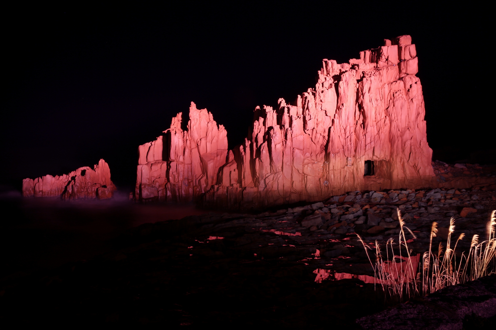
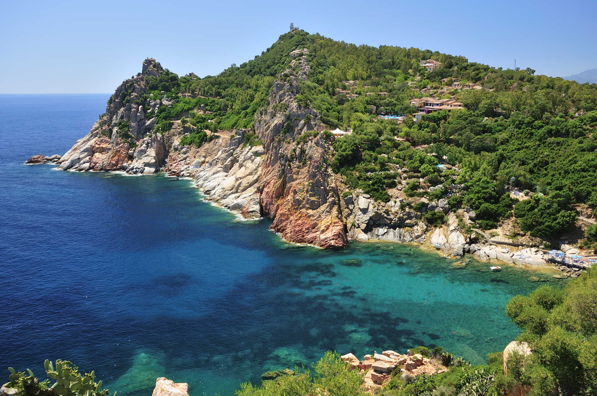
Rocce Rosse
A breath taking view named after the extraordinary particularity of the porphyry cliffs that rise from the sea. The Red Rocks Bay opens to the east of the Arbatax port, a tourist neighbourhood of Tortolì, with a background of white rocks and tall red granite boulders that give this place a unique and fascinating look. Their reflection give the water an ever changing colour around emerald green. This is where the final scene of cult film by Lina Wertmüller, Swept Away (1974), was shot. The overall combination is unique in the world, although other red porphyry cliffs dot the Ogliastra coast, such as is Scoglius Arrubius, two stacks twenty metres tall, symbol of the magnificent Cea beach, a few kilometres to the south.
The porphyry boulders are a great attraction for experienced divers. Open sea faces the “red” little beach. Around the beach you will find all the services you need: plenty of parking space (for campers as well), hotels, cafés, restaurants and nightclubs – local nightlife is particularly animated. Behind the Red Rocks lies stupendous Cala Moresca, named after the Saracen pirates (is morus) who pillaged the coast in the 8th century. The beach has a clear flatbed, granite rocks, golden sand and lush vegetation around the cove. Only a few kilometres away, other unmissable beaches: Lido di Orrì, sixteen kilometres of coast made up of little coves and deserted beaches, including splendid Cala Ginepro, beautiful San Gemiliano, and the previously mentioned tropical paradise that is Cea, more than one kilometre long, part of the territories of Tortoli and Barisardo.
Arbatax, a tourist and commercial port on the eastern coast, probably owes its name to the Arabic word meaning “fourteen”, referring to the fourteenth lookout tower that stands nearby. The place is the unusual and unique scenario of a fascinating and traditional yearly event, the Rocce Rosse Blues festival, a display for internationally famous musicians.
Capo Comino
A coastal paradise that will leave you breathless. The beach of Capo Comino, in the territory of Siniscola, in Baronìa, has fine white sand forming gigantic white dunes, dotted with junipers, typical Mediterranean plants and rocks scattered over the sandy shore. The sea stands out, due to its unusual shade of light blue. The waters are extremely transparent and fit perfectly with the green vegetation and with the island of Ruja, a red porphyry skerry that you can swim to or reach on foot. To the south, where the area becomes rocky, there is a lighthouse, situated near the promontory that gives its name to the area.
The locality has ample parking and places for dining/refreshments. In addition, it is the ideal destination for surfers and it is very popular with underwater fishing enthusiasts. Behind the beach, there is the wetland area of the ponds of Salina Manna and Salinedda, the home of rich lake wildlife. This natural setting was the ideal location for films made by several film directors, like Lina Wertmüller, who filmed several scenes of the film 'Swept Away' (1974) here, as well as Carroll Ballard ('Black Stallion', 1979) and Guy Ritchie ('Swept Away', 2001).
You can easily get to the beach by passing through the tourist village of La Caletta, where, as well as its well-equipped port, you can also enjoy another wonder of the Siniscola coast.
The depths, in front of Capo Comino, a few hundred yards from the shore, are a haven for diving enthusiasts: here, you will find the remains of a Roman fleet from the period of the Emperor Nero, which sank during a storm. In the same abysses, there is also the wreckage of a ship named Commandante Bafile (from 1942), as well as a small French aircraft (from 1963).
Santa Maria Navarrese
By the time you get to Santa Maria Navarrese, you will have been enchanted by the romantic streets near the coast bordered by turquoise water, with benches that invite contemplation and white sails silhouetted out in the sea.
The church of Santa Maria of Navarra, dating from the eleventh century, and the Spanish tower, built in the seventeenth century to guard the coast, represent the historical memory of the town. Under the shade of pine trees and dominated by the tower, the terrace overlooking the gulf offers a view of the marina to be enchanted by. The legend attributes the name of the ancient church to the princess of Navarra who ordered its construction to express her gratitude to the Virgin Mary.
As for the most beautiful places in the vicinity, we recommend Cala Sisine Beach, the pearl of the Gulf of Orosei, with large grains of sand and two imposing rocky outcrops on either side, and also the shallow waters of Cala Mariolu, Cala Follo, Cala Goloritzè, with turquoise waters and super white sand, and Cala Luna, considered to be one of the most beautiful Mediterranean beaches.
The Mediterranean brush, gathered in a thick wood of oak, juniper and pine tree, looks over the cliffs to the bold brushstrokes of the sea. Mouflons, Eleonora's falcons, golden eagles and seagulls chose this place that is still wild and rugged to breed.
Nearby is the incomparable beauty of the wild Baunei landscape: limestone ramparts rising steeply from the sea, sea expanses of indescribable splendor and waters as green as fresh sprouts and as blue as the sky make of this resort a must see destination.

Su Sirboni
Un paesaggio incantato: il rumore della risacca, la brezza che espande i profumi mediterranei, le tonalità del mare, un luogo di rara bellezza quasi mai affollato. Selvaggia e suadente, isolata ma accogliente, tra rocce frastagliate, con pinnacoli che sembrano torri, ecco sbucare un po’ inaspettata, la spiaggia di su Sirboni. È una lingua di sabbia bianca e finissima, incastonata in una insenatura nascosta tra porfidi rossi, punteggiata dai bungalow di un vecchio resort, abbandonato da decenni e inglobato ormai nella natura del luogo. Il suo nome significa ‘il cinghiale’ ma è nota anche come Cala Francese: splende sulla costa del sud dell’Ogliastra, nel territorio di Gairo sant’Elena. La raggiungerai uscendo dalla ‘vecchia’ statale 125 a Cardedu e dal paese procederai per otto chilometri, prima verso la marina di Cardedu, poi per Perd’e Pera.
Su Sirboni va cercata e desiderata. Dal parcheggio sulla strada prenderai un sentiero di circa 300 metri. La porta d’ingresso è un varco ricavato nella folta vegetazione. Pochi scalini, poi giù fino agli scogli. Ti aspettano 15 minuti di camminata - immancabili scatti fotografici compresi - tra scisti e corbezzoli, rocce ruvide e spigolose, massi tondi e lisci. La meta è un arco lungo 200 metri di sabbia chiara, soffice e morbida come il borotalco, ‘inatteso’ in un tratto di litorale quasi tutto ciottoloso. Alle sue spalle piccole dune e verde mediterraneo impreziosiscono la baia. Il fondale è basso per decine di metri, l’acqua limpidissima e brillante di colore azzurro e turchese, ideale per snorkeling e pesca subacquea.
Una perla tanto splendente quanto selvaggia, che sarebbe probabilmente la spiaggia più bella di una qualsiasi altra regione italiana, eppure è poco nota. Troverai poco affollamento persino in alta stagione, forse perche la relativa fatica dell’itinerario arrivarci scoraggia un po’. Niente stabilimenti balneari, niente noleggio lettini, bar, solo lo ‘scheletro’ del resort abbandonato. Allora meglio portarsi tutto il necessario, per bere, mangiare ed esplorare, incluse maschera, pinne e scarpette da scoglio. Ed è consigliabile restarci sino al tramonto, quando la luce del sole dipinge di mille sfumature di rosso le rocce circostanti, una magia nella magia che ti lascerà un ricordo ancor più speciale e la voglia di tornarci appena possibile.
Insieme a su Sirboni, la marina di Gairo offre un altro spettacolo, diverso ma altrettanto suggestivo, Coccorrocci: quattro chilometri di sassolini porfirici, tondi, lisci e lucenti, modellati dal tempo. Ci vivono le chiocciole marine, che danno nome alla spiaggia, la più grande nell’Isola tra quelle interamente in ciottoli. Il contesto è suggestivo: le pietroline scure si combinano con le tonalità azzurre del mare, mentre attorno incombono rocce di porfido rosso e i ginepri incorniciano di verde e inebriano di profumi la spiaggia. Il luogo è ideale per il trekking: venti minuti a piedi dalla spiaggia troverai le piscine naturali alimentate dalla sorgente su Accu ‘e axina Nella marina si segnala anche la spiaggia di Lispedda, detta ‘la spiaggetta’, divisa in due da scogli e con ghiaia e ciottoli. Dal mare il territorio di Gairo arriva sino al Gennargentu. Altri paesaggi da non perdere sono la grotta Taquisara, nel monte Ferru, e l’imponente Perda ‘e Liana, la vetta dei tacchi d’Ogliastra (1300 metri), monumento naturale ‘protetto’, popolato da mufloni e sorvolato dal gipeto.
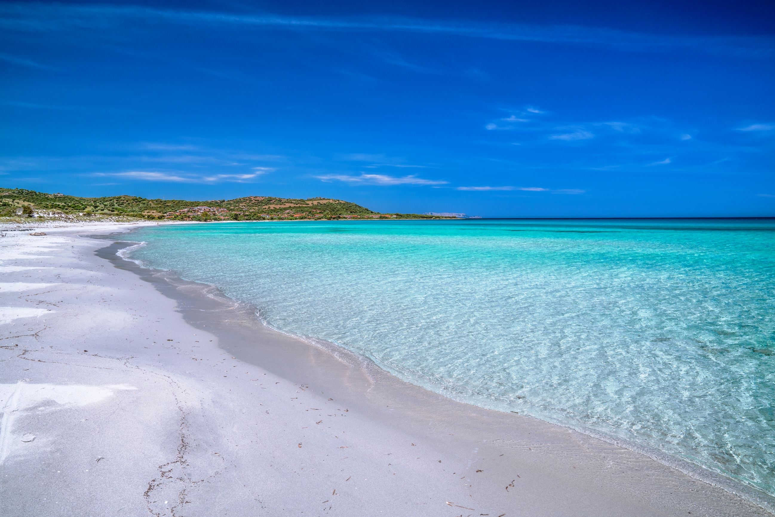
Cala Ginepro - Tortolì
A true gem of Ogliastra. Within theLido of Orrì, in the coastal territory of Tortolì, you will find Cala Ginepro, which gets its name from the small juniper forest situated by the coast. The cove is famous for its transparent waters and its beach with fine sand and pebbles, smoothed by the erosive action of the sea. The green vegetation, the pure white sand, the deep blue sea and the pink granite rocks are the colours that nature has chosen for its palette, painting this wonderful scenario: you can lose yourself in this natural beauty while relaxing completely.
The low, rounded rocks act as a border to several areas of the beach, making it look like an outdoor swimming pool. The shallow waters also makes it suitable for children's games. Long walks and sunsets filled with poetry make the cove one of the most poetic on the eastern coast, accompanied by the intense evening fragrance of the junipers.
The beach is equipped with ample parking, places for dining/refreshments and beach umbrella, sunbed and pedalo rentals. This windswept area is the ideal destination for surfers and it is very popular with those who like to do some underwater fishing or snorkelling. It is easy to get to along scenic trunk road no. 125. While on holiday in Tortolì, you will have a chance to visit the Orrì coastline, 16 kilometres of wonderful, hidden little coves.A little further south, don't miss your chance to stretch out on the soft white sand of Cea, another gem situated along the Ogliastra coast. While in the village of Arbatax, protected by the Rocce Rosse(Red Rocks), you will find an 'urban' paradise called CalaMoresca.
Cala Moresca - Tortolì
Practically a small urban paradise. Cala Moresca is located within the town of Arbatax, neighbourhood of Tortolì, almost protected by Rocce Rosse (Red Rocks) and beneath the promontory of Bellavista. The bay consists of splendid red porphyry rocks, mixed with granitic rocks, forming an ensemble of homogeneous colours. The beach has a deep and clear bottom of gravel sand and rocks. Thick vegetation colours the bay Mediterranean green.
To get to the beach, follow a convenient path among rocks and trees, with cement steps, accessible to children as well, as long as everyone is careful. The shallow waters are perfect for children and less experienced swimmers. Aficionados of underwater fishing and snorkelling love this beach, as its bottom is brimming with starfish and coloured fish. There is a parking area, and it is possible to rent umbrellas, beach chairs, paddleboats, boats and scuba diving activities. Cala Moresca is not open to the wind, and its very calm sea is perfect for intense days of relaxation. However, several centuries ago it was disputed land and far from calm: in fact, it is named after is morus, Moor pirates that raided the entire coast in the 8th century.
Only a few kilometres away, you will find other unmissable beaches. Starting with Lido di Orri, sixteen kilometres of coast with little bays and deserted beaches, including the splendid Cala Ginepro. Then there is San Gemiliano beach. And then you will find the soft white sand, the smooth rocks and the emerald hues of Cea, more than one kilometre long, three quarters of which belong to Tortolì and one quarter to Barisardo. Three hundred metres from the beach, two sea stacks twenty metres high: is Scoglius Arrubius, the symbol of Cea, accessible to swimmers or in a paddleboat. In the Barisardo territory, do not miss the Torre di Barì beach.
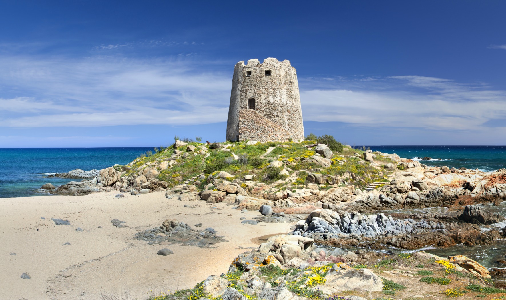
Torre di Barì
Four and a half kilometres from the centre of Barisardo, this beach is 8 kilometres long and one hundred metres wide. The Torre di Barì beach is split in two by the rocky promontory on which the Spanish watchtower is located. Built in 1572 to defend the territory from Saracen pirates, the fort overlooks the sea and the shore. The northern part of the beach, characterised by golden thick-grained sand and demarcated by a scented pine grove at the feet of the basaltic plateau called Teccu, is traditionally called mari de is ominis (the men’s sea). It is separated from the southern part, characterised by thin white sand and small pebbles, called mari de is feminas. This separation dates back to the post-war years, when the two parts of the beach were attended by men and women, separately.
The southern part extends all the way to a small granitic plateau that marks the boundary with sa Marina Tramalitza, another splendid “Barì” beach, never crowded, of light sand that dives into the crystalline sea, with green hues. Beyond there is the shore of Perda ‘e Pera, in the Cardedu territory.
The waters of Torre di Barì are azure and clear, thanks to oceanic posidonia and its filtering action. The seabed is shallow but deepens rapidly, becoming rocky around the tower and therefore perfect for snorkelling and underwater fishing. The beach has all the necessary facilities, access to disabled people, rental of umbrellas and beach chairs, in addition to plenty of parking space and a diving centre. Exposed to Gregale and Sirocco, it is the perfect destination for surfers and kite surfers. Around the beach, you will find hotels, residences, camping sites, cafés, restaurants and clubs.
To the north of the town, do not miss the paradise that is Cea: over one kilometre of soft white sand, with shallow waters, smooth rocks and emerald hues in the water. One-fourth of it is part of the Barisardo territory, while the remaining three quarters belong to Tortolì. Three hundred metres from the coast, in the centre of the shore, two rocky stacks of red porphyry stand out, twenty metres high: is Scoglius Arrubius, the symbol of this beach.
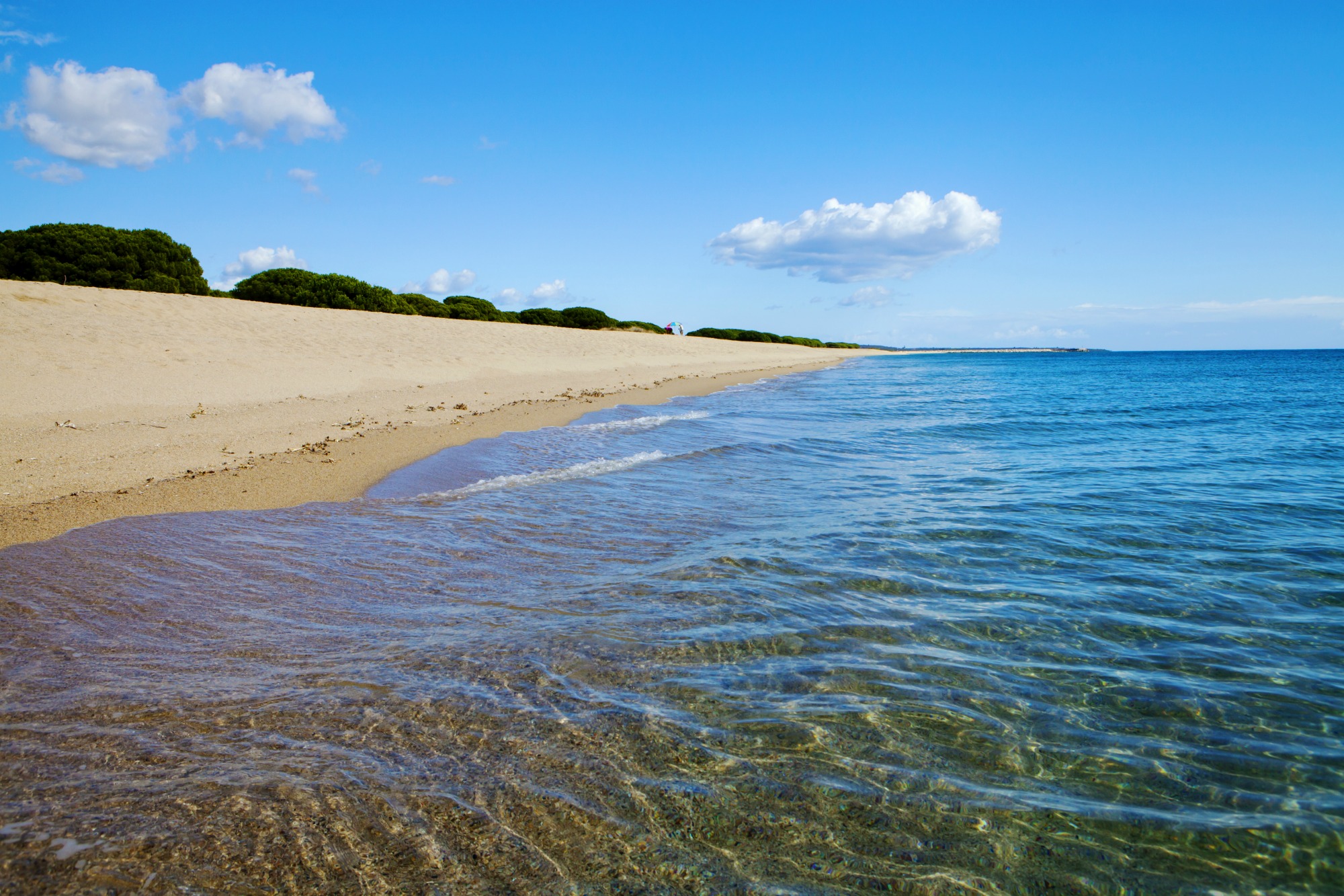
Marina di Orosei
Two kilometres of fine, light sand mixed with shells and gravel. La Marina di Orosei, which you can comfortably reach from the town, has transparent waters whose hues of blue change constantly as the sun reflects on the bottom, which deepens suddenly. Often hit by the wind, this is the perfect destination for surfers.
The beach boasts all amenities and services: it is accessible to disabled people, visitors can rent beach equipment and paddleboats, there is plenty of parking space available (for campers as well), hotels, bars and restaurants. Behind the marina, the abundant vegetation, typical of the Mediterranean scrub, frames the pond and the mouth of the Cedrino river. Much loved by underwater fishermen and scuba divers: about two miles from the beach lies one of the island’s most fascinating and best preserved wrecks, the KT, a German landing craft about 70 metres long that sunk in 1943 after being hit by the English submarine patrolling the gulf at the time.
The Orosei coast offers many other pearls: the small bay of sas Linnas Siccas, within the splendid Cala Liberotto; Cala Ginepro, with fine white sand mixed with smooth pebbles that massage your feet as you walk along the shoreline of an azure and turquoise sea. And sa Curcurica, the best beach for children for its shallow waters that gently deepen as you swim away from the beach and behind which a thick pine grove offers shelter during the warmest ours. The wonderful Oasi di Bidderosa, Orosei’s most beautiful and famous beach, a protected natural park. And, finally, the Osalla beach, halfway to the Dorgali territory, famous for its waters that are perfect for diving (thanks to a famous “draught”). In addition, do not miss the occasion to take a boat and visit the coves of the forty kilometres of the gulf, paradises where nature is unblemished and wild: cale Fuili, Luna, Sisine, Biriola, Mariolu and Goloritzè.

Porto Santoru
Porto Santoru is in among the many pebbly beaches along the low, rocky coast in the municipality of Lanusei. It is located to the south of Barisoni and to the north of Caletta Pagliuzze Dorate, and has a jetty and the ruins of abandoned buildings which were once used to load the minerals extracted more inland. It shares the natural beauty of the beaches which border it, given by the colour of the crystalline sea and the wild aspect of the rocky coastline.
Cala dei Gabbiani
“Still little known, obscured by the fame of the nearby Cala Mariolu, it bears the same characteristics: crystal-clear water in shades of green and blue, a cliff polished by time and a lido of white pebbles.” This is why in 2017, Cala dei Gabbiani was chosen by the experts of Skyscanner, a famous holiday web portal, as the second most beautiful beach in Italy. The classification values less-known creeks, ‘hidden pearls’, just like this corner of paradise in the southern part of the Orosei Gulf, within the Baunei territory. It can be reached by sea, like the other ‘pearls’ of the Ogliastra coast, via private boat or on one departing from the marinas of Cala Gonone, Arbatax and Santa Maria Navarrese, or by trekking along a difficult and challenging path (3-4 hours’ walk), recommended for the more experienced and accompanied by guides, starting from the Golgo plateau through the Ispuligidenie forest.
The flat spur of the Ispuligi peak slopes down gently. Until 1953, it was the docking point for merchants who loaded the coal produced by the furisteris (coalmen) – separating the enchanting and pristine Cala dei Gabbiani from the more famous Cala Mariolu, which represents the natural continuation to the south and with which it shares the same scenic impact. Until the end of the 20th century, this stretch of coastline was jointly referred to as Ispulige de nie, or ‘snow fleas’, in reference to the pebbles smoothed by the waves that characterise this area, being flattened and round, coloured cream, white and pink, similar to sugared almonds, all mixed with the white sand and other larger pebbles. These are so-called ‘landslide’ beaches, originating from material falling from the rocks. It is not by chance that the name of the beach is recent, as it derives from the hundreds of seagulls that find refuge here at dusk before flying off in the early hours of the day. From its waters of a thousand shades of blue created by a play of sunlight, emerge scenic bright white rocks. The seabed is certainly worthy of seeing up-close on a dive.
The cove is around 250 metres long, in some points being over ten metres wide and enclosed to the north and south by the mountain overlooking the sea. Behind them, 500-metre-high rock faces rise up, illuminated by the sun and dotted with lush vegetation. The cliffs withdraw to leave room for a wide escarpment covered by dense forest framed by the ridge of the limestone mountain of Serra e’ Lattone. To the north, beyond Cala Mariolu, you can visit Cala Sisine and, halfway between the territories of Baunei and Dorgali, Cala Luna. To the south, the coast continues to a sheer drop to the sea of about one kilometre, before reaching Cala Biriola, Cala Goloritzé and the small beach “La Sorgente”. In the distance, you will see Capo Monte Santo, bordering the gulfs of Orosei and Arbatax, near the picturesque Grotta del Fico. Another gift of nature is seeing the spectacle of flights by of birds such as the peregrine falcon, Eleonora’s falcon, European shag and golden eagle.