
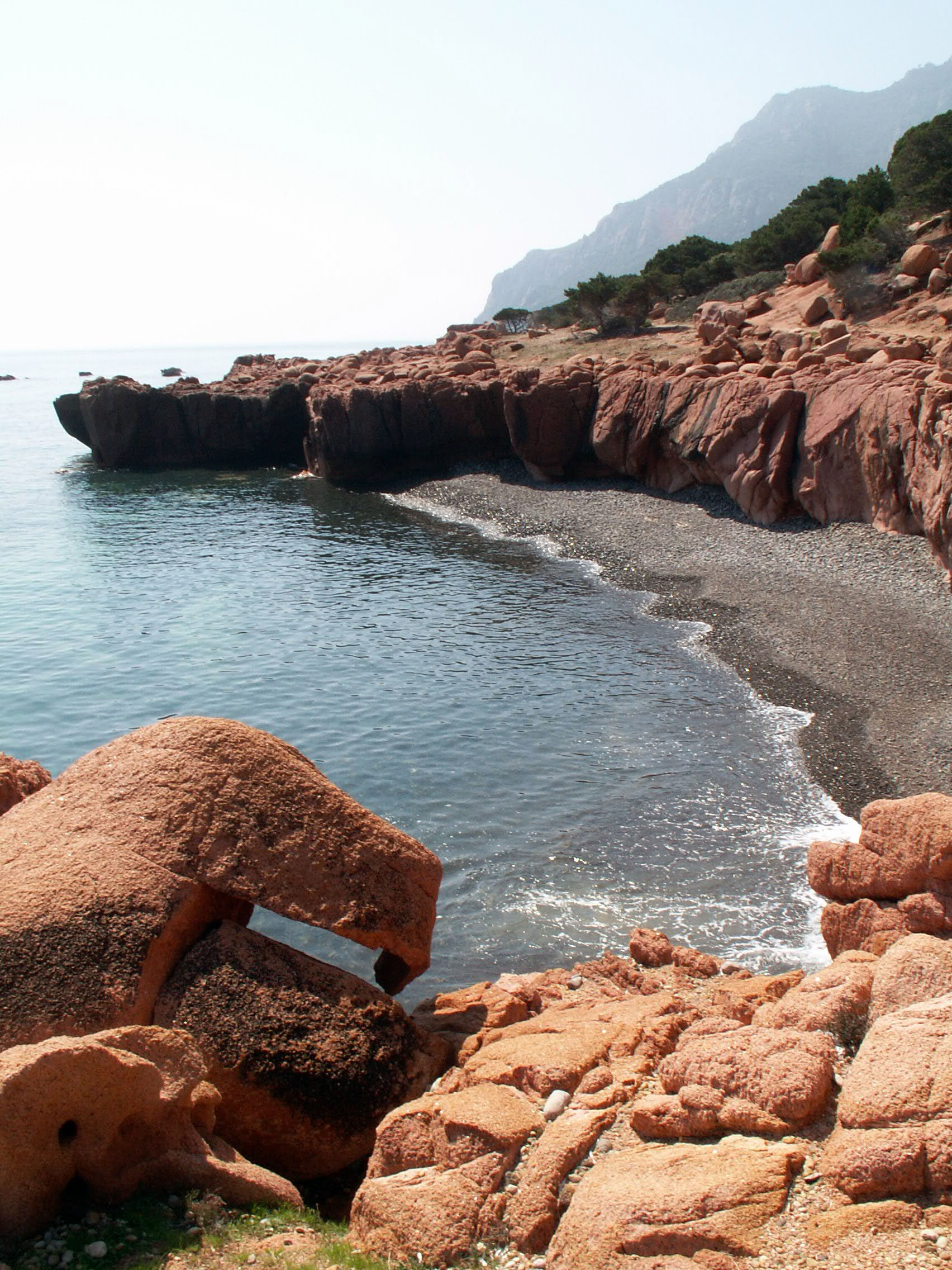
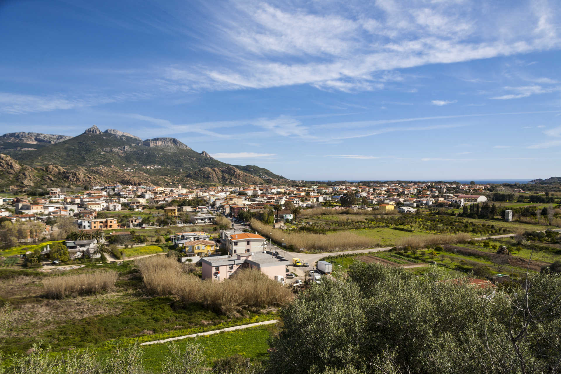
Coccorrocci
As many as four kilometres of pebbles shaped by time, the habitat of is coccorroccius, sea snails. The Coccorrocci beach, a pearl of Marina di Gairo, is named after these little animals, and is characterised by a very beautiful natural landscape. Mounts Ferru and Cartucceddu loom over the coast with their red porphyry rocks and juniper trees frame the beach with green and fill it with inebriating scents. The volcanic pebbles range from white to pink, from grey to greenish, and gradually fade as they disappear into the crystalline sea. Thanks to the clear water, you can admire the sea bottom, rich with marine flora and fauna. The shoreline is perfect for long, relaxing walks.
Coccorrocci, one of the most famous beaches of Ogliastra, is equipped with hotels. To the north, it confines with Marina di Cardedu, with the splendid Perdepera island in particular, and to the south with Marina di Tertenia, divided by a promontory you can cross in a long trekking session all the way to enchanting Foxi Manna beach. Along the Gairo coast, do not miss another little gem that looks like heaven: the su Sirboni beach (“the wild boar”), also called Cala Francese. Ultra-fine and white sand that dives into the clear azure sea with shallow bottom for many metres, lined with thick green vegetation. Never crowded, this beach has a wild, uncontaminated charm.
For lovers of active tourism, the beach is perfect for trekking, photography, bird watching, Nordic walking and orienteering. Not far from the beach – only a twenty-minute walk – you can enjoy the natural pools fed by the water from the su Accu ‘e axina spring, from Mount Ferru: red porphyry rocks emerge among the lush vegetation, embracing majestic water bodies where you can bathe as you like.
Castle of Pontes
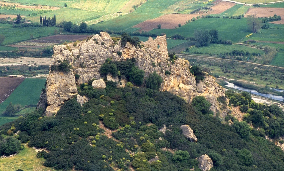
“Ghosts of the ancient Barons came down from the Castle ruins above Galte”. This is how Grazia Deledda made the ruins of the castle of Pontes eternally famous, in the pages of her masterpiece ‘Canna al Vento’. Today, it is an integral part of the Grazia Deledda Literary Park, an itinerary that includes the places mentioned by the Nobel prize-winning writer. From the 11th century, the fortress, built on a hill at the foot of Mount Tuttavista, which dominates the plain of the Cedrino river, performed a strategic function in protecting the connections between the eastern coast and the hinterland. At that time, Galtellì was an important religious and political centre of the Gallura Giudicato and in the 14th century it was attacked and conquered by the Aragonese Crown.
The castle was inhabited until the 15th century before being abandoned: its last owner was Baron Guiso, around whom there are numerous legends: his ghost would roam the ruins at night, unlike his family, who were forced to wander the underground areas. On one occasion, the Baron’s ghost is said to have met a poor farmer carrying wood. The baron asked him for some wood with which to heat his family and the farmer, despite the hardship he was suffering, agreed without accepting anything in return. From that day on, the farmer became rich. After having supplied the spirits of the castle with wood for the entire winter, he received sacks full of gold in exchange.
You can visit the castle at the end of a path surrounded by mastic trees, where you will notice ancient lime furnaces. The building was inserted onto a previous Roman fortification and incorporated limestone spikes, taking advantage of the shape of the rocky outcrop. It was surrounded by a secondary defence wall at the base and several vestments still exist. There are reports of two towers that were still visible at the end of the 19th century, while today you will be able to identify the remains of one of them in a corner position. A flight of steps will take you to the upper level, where there are traces of an oven and an underground cistern. From up there, you can admire a captivating view of the Cedrino valley as it stretches towards the Gulf of Orosei, following the course of the river. Next to it stands the imposing profile of Mount Tuttavista, the height of which exceeds 800 metres above sea level. During the ascent, you will find sa Preta istampata, a rocky wall on which atmospheric agents have opened a large and unusual circular hole, creating a natural ‘window’ to the valley.
In the village of Galtellì, which is part of the regional circuit of pilgrim destinations, you can visit the complex of the former cathedral of San Pietro, containing a cycle of medieval frescoes, and Casa Marras, an eighteenth-century noble residence in which there is an ethnographic museum.
Foxi Murdegu
The coastline of southern Ogliastra, with Monte Ferru standing over it, is a continual discovery of coves and wide beaches, where the colours of nature, between sea, sand and rocks, look like they were painted by an artist. One of the many ‘pearls’ extends south of the promontory on which the Tower of San Giovanni Sarrala stands: it is a strip of fine, light sand, called Foxi Murdegu, also known as Melisenda. It’s easy to get to: take the panoramic state road SS 125 as far as the crossroads – which is well-signposted – towards the Marina of Tertenia and, from here, proceed in the direction of the locality of Barisoni for about ten kilometres. A detour to the left will take you to the beach after another three kilometres. An inebriating landscape awaits you. The sea is surprisingly transparent, with a shimmering blue colour, thanks to the play of light created by the sun reflecting on the seabed, while the surrounding vegetation frames the landscape ‘painting’ with greenery.
The beach has a few pebbles, while the waters are shallow and the seabed is sandy, gently sloping out towards the open sea, making it suitable for children. The northern stretch of the beach is called dog beach and it is equipped for you to take your four-legged friends there. The entire coastline is constantly windblown, making it a great destination for lovers of sailing sports. The most sheltered side is the one closest to the promontory, which features a predominantly rocky seabed, so it is less frequented and therefore even more suitable for enjoying the sun in peace.
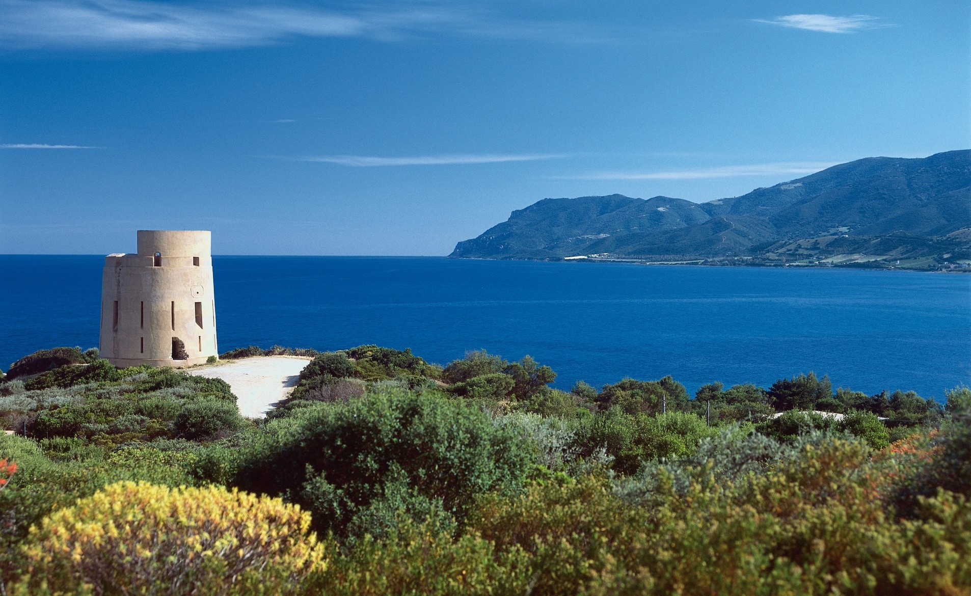
However, as well as relaxing, you can also visit the tower on the promontory, which can easily be reached by car. According to tradition, the ancient village of Tertenia emerged here, but was abandoned because of pirate incursions. The fortified building was presumably constructed at the beginning of the 18th century to watch over the stretch of coast between Capo San Lorenzo and the Tower of Barì. It was the fort that showed heroic resistance against the attack of Barbary pirate ships in 1812, and it then became a bunker during the Second World War. Towards the end of the 20th century, restoration work recovered its original appearance. You can see the ‘casemate’, a vaulted room on the first floor, the place-of-arms and a terrace on the upper level, with crenellated embrasures on the sea side.
Five kilometres north of Foxi Murdegu, you will find the other splendid beach of the Marina di Tertenia, namely Foxi Manna, bordered by rocks and also surrounded by vegetation. Its seabed is entirely sandy, with a sea reflecting shades of turquoise and green. Behind it, stands the imposing nuraghe Aleri, the best preserved nuraghe in the Tertenia area. Less than three kilometres from the Tower of San Giovanni Sarrala, you will find the nuraghe Nastasi, with its central tower surrounded by a bastion with four other towers.

Palmasera
The air is filled with the scent of oleanders, while the sunlight reflects on the reddish grains of shingle and on the emerald green surface of the sea, creating captivating plays of light. This setting is the Palmasera beach, the broadest coastline of Cala Gonone, a marine hamlet of Dorgali. The shingle is mixed with fine, light sand, adding a further touch of colour, while a few rocks emerge several metres from the shore, punctuating the open landscape to the right on the southern side of the Gulf of Orosei and towards the tourist port of Cala Gonone to the left. There are numerous services on the beach: parking, access for disabled people, refreshment areas, beach umbrella, deckchair and boat rentals. The shallow waters and gently sloping seabed makes it suitable for children.
You can set off on an excursion from the port - by boat or dinghy - to explore the wonders of the gulf, visiting the Grotte del Bue Marino (Sea Oxen Caves) and the Grotta del Fico, as well as some heavenly coves: Cala Luna, Cala Sisine, Cala Biriala, Cala Mariolu and Cala Goloritzè. There is also a ‘taxi’ service, which allows you to get to a particular beach of the gulf directly or return to Cala Gonone by sea after some intense trekking.
The beach is the natural continuation of Sos Dorroles, which extends towards the south: the sand has the same features but what makes this stretch special is the wall of calcareous detritus behind it and around it, with an unusual orange colour. Beyond the northern limit of Palmasera, groups of rocks alternate with sandy stretches as far as the port. Next to it, you will find the Central beach: it is surrounded by vegetation and dominated from above by an Art Nouveau villa dating back to the 1920s, considered the ‘historic’ beach of Cala Gonone. The beach has light sand with medium-large grains and pebbles and the reflection of the sun’s rays creates captivating colour effects.
Following the scenic Viale Bue Marino road to the south, you can admire the other two jewels of the Cala Gonone coast: three kilometres from the town, there is the beach of Ziu Martine, featuring the beautiful contrasting colours of the white limestone cliffs and the dark basalt rocks emerging from the crystal clear sea; while, at the end of the road, a few steps will allow you to admire the small, wild Cala Fuili with its white sand mixed with stones and a sea reflecting shades of turquoise and green. After a visit to the beaches, you can ‘dive’ into the underwater world of the Gulf of Orosei and other Mediterranean marine environments by visiting the acquarium of Cala Gonone, the largest structure of its kind in Sardinia. Twenty-four tanks for a journey filled with fun, discovery and environmental protection.
Municipal antiquarium - Irgoli
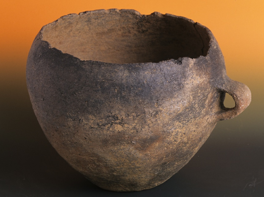
A tale that spans millenniums, from prehistoric times to the Middle Ages, touching on sacred and daily themes. You will follow this journey via the fascinating objects on display at the Antiquarium of Irgoli, located in the old municipal building. The museum is home to items discovered almost exclusively in the area around the town, and include relics from the Nuragic sanctuary made up of the temple of Janna ‘e Pruna and from the sacred well known as su Notante.
The exhibit is spread over two floors and includes informational panels, maps and iconographic reproductions. You’ll see objects used in both manual and production activities like axes, blades, millstones and mortars, as well as spindle whorls and spools for weaving, jars and fragments thereof that bear witness to the development of ceramic production over the centuries. Of particular interest is a pintadera, a type of stamp used for the preparation of decorated breads. You'll also see tools used for processing milk, like boiling pots and curd strainers. Glass paste necklaces, brooches and bronze bracelets are, on the other hand, an example of the jewellery worn at the time. The votive offerings and funerary objects, especially bethels and notched ashlars, came from a sacred area on Mount Senes. There is also a special area where you can admire evidence of petroglyphs that have been uncovered over time.
The museum organises workshops and fun educational activities for children in which they can pretend to be archaeologists and learn about the ancient techniques used to work clay and bread. A visit to the museum should also include the exploration of the Nuragic Janna ‘e Pruna temple and the sacred su Notante well. The complex sits in a lovely natural environment at 600 metres above sea level with views over verdant valleys, and from which you can catch a glimpse of the peaks of both Gennargentu and Supramonte. The temple itself was made of granite blocks with a rectangular atrium and a circular cell. It is fenced in by a temenos, or sacred protective wall. Outside is another walled-in structure, with yet another wall that encircles all of the buildings of the sanctuary. Downhill you’ll find the sacred well, built with basalt, of which only part of the façade around the well remains. Water still gushes into a rectangular basin inside a roofed area with a trapezoidal entrance.

Cala Sisine
It is perhaps less well-known thanother coves in the Gulf of Orosei - Luna, Goloritzè and Mariolu - but it will nevertheless make your holiday a dream, thanks to the blue sea and a seabed of round, white pebbles. Cala Sisine is located at the end of a codula, which is a gully, once a riverbed and now the mouth of a small torrent, which originates on the plateau of Golgo,in the Supramontedi Baunei area.
Approximately 200 metres wide, it looks out onto the cliffs of Serra Ovra that stand over 500 metres high and overlook the sea. It is bordered, almost enshrouded, by rocky crags, while the gorge is covered by the greenery of centuries-old carob trees and holm oaks. Quite ironically, although it is one of the most beautiful seaside localities of all, it has a unique mountainous appearance. The waters are a shimmering turquoise colour due to the play of sunlight reflected upon it. The seabed consists of light grains of limestone sand and rounded stones, the ideal setting if you want to take your mask and do some snorkelling.
To the south, there is a spectacular cove, fifty metres high and a trampoline for the bravest and most expert divers. You can get to the cove in private boats or using services departing from the ports of Arbatax,Cala Gonone and Santa Maria Navarrese. It can also be reached on foot, but with greater difficulty, along marked-out trekking trails. If you want a little refreshment after your walk, there are bars and places for dining/refreshments.
In ancient times, it was known as Portu ‘e Sisine, a landing place for cargos of coal. In fact, to the north there is still a building constructed by the carbon merchants. Tools have been found in the area,revealing the presence of humans here about 4000 years ago. In past centuries, stopping here was a must, after having crossed the terrible monti insani, meaning insane mountains (which is where the name Monte Santo comes from), as Cicero defined them. The oldest inhabitants tell us that, to the south of the beach, during the Second World War, a submarine stopped in a sheltered area known as Su Stuggiu (the hiding place). During your trip along the gulf, in the Baunei territory, don't miss an opportunity to stretch out on the (more) famous and equally charming coves of Biriola, Goloritzèand Mariolu.

Lido di Orrì
A picture-postcard location, an enchanting triumph of contrasting colours and fragrances. The Lido di Orrì is considered one of the most beautiful and characteristic beaches of the island's east coast and is certainly the largest and longest - nine kilometres of small coves embraced by granite cliffs that each lead to sumptuous beaches that are almost never crowded. This is the splendid calling card of Tortolì, the main town of Ogliastra, whose residential area lies around four kilometres away. Its coastline is the most awarded in Sardinia, having been granted 'bandiere blu' (blue flags) by Legambiente. The beach of Orrì is formed of white and golden sand that is very fine and soft, such as to almost be impalpable. The water is shallow for the first 300 meters or so from the shore, before the foundation gently slopes to allow less experienced swimmers to immerse themselves without worries, also being ideal for children to play. The transparent and crystalline waters take on iridescent hues, from emerald green to turquoise, with a play of light created by the sun reflected on the seabed.
For those who love to go for long swims or explore the seabed, Orrì invites you into its blue water, rich with marine wildlife, perfect for recreational fishing and diving enthusiasts. Emerging close to the shore are smooth, rounded grey rocks that render the landscape truly striking. This wind-swept area is very popular with surfers whilst the beach is backdropped by a shaded area perfect for relaxation in a pine forest.
The main beach of Orrì, known as the ‘Spiaggia Grande’ ('Big Beach'), is an expanse of around 3.5 kilometres of fine white sand, with ample parking nearly that is also suitable for campers. Numerous services are offered including rental of beach equipment, pedal boats, canoes and jet skis, along with various dining options and kiosks, plus games for children. This is the beach of the campsite. There are also hotels nearby. During summer evenings, the flanking street is enlivened by stalls, clubs, music and entertainment. Further south, you will find two other stretches of beach, Foxilioni and 'Golfetto', where the sand is interspersed with granite outcrops. It is surrounded by a frame of fragrant Mediterranean scrub. One of the jewels within Lido di Orrì is Cala Ginepro, whose name hails from a grove of junipers that extends to the beach. The green of the vegetation creates a beautiful chromatic contrast with the blue waters, the fine white sand mixed with smooth pebbles, and the rose of the granite rocks in the surrounds.
Next to the Orrì coast lies another wonder of Ogliastra, being Cea, a kilometre of fine white sand, with a shallow seabed and blue sea, before which arise two red sea stacks, is Scoglius Arrubius, which can be reached by swimming or skating, forming a palette of colours that has to be seen. Taking a stroll is a sensory experience in itself - the feel of the silky sand, the scents of the Mediterranean, the sounds and colours of the sea. Then there is the red porphyry alongside the Tortolì port of Arbatax, with the Rocce Rosse ('Red Rocks') being a must-see, as a spectacular natural monument that 'shields' the beach town of Cala Moresca. A little further south are the blue hues of Porto Frailis. Much darker are the basalt rocks of Punta su Mastixi that forge coves dotted with little grottos. From here, the view extends from Capo Sferracavallo to the south right up until Capo Monte Santo to the north. The seabed unfurls with a succession of stone steps leading to the sand.
Tortolì is the gateway to Ogliastra, the land of longevity, offering access to a multifaceted territory. In addition to the tropical beaches, you will find forests, fertile plains, ponds and cultivated hills. After diving into the sea, you can savour an immersion into the culture, traditions and archaeology, especially within the site of s’Ortali ‘e su Monti, a representation of Sardinia's prehistory. To conclude, stop in the restaurants to savour local delicacies, from culurgiones to roast meats, accompanied by cannonau wine.

Washhouse of Ulassai
The creative flair of great artists, including two of the most important names on the Sardinian cultural scene, made available to transform a place of ‘public utility’ into a work of art. It is no coincidence that the first artist who wanted to bring new life to the Ulassai washhouse was the most illustrious personality born in the village: Maria Lai, in collaboration with her fellow villagers. Later, Costantino Nivola, Guido Strazza and Luigi Veronesi also intervened to transform the old space, used by women to wash wool, into a ‘mini-museum’. Maria Lai’s work dominates the interior of the building: it is a ceiling-mounted frame, created in 1982. A series of ropes are intertwined and tied to iron tubes, forming a traditional frame. At the back, the colours of the ceiling walls
stand out – black, grey and red – while in the lateral part, tree trunks were embedded in the wall.
The building, commissioned and built between 1903 and 1905, has a parallelepiped shape and is encircled by a protruding ledge. On the main façade you will see three arched openings - two entrances and a central window -, with granite ledges. Inside, there are two rows of tubs, separated by a low wall. Above, you will notice a series of pipes, over which there are tiles, all made of bronze. The flow of water on the tiles makes an almost ‘musical’, melodic sound. The installation, a 1987 work designed by Costantino Nivola, is called ‘the fountain of sound’. Each short side located outside contains a fountain, framed by an arch. On the west side, there is the ‘fountain of wheat’, a work dated 1989 by Guido Strazza, who is also the creator of the paving in the square. The fountain has a mosaic of white marble and black and white granite tiles as a background, forming lines similar to ears of wheat. Five years earlier, on the opposite side, Luigi Veronesi created the ‘fountain of the spring’: also a mosaic, created with granite tesserae, pink and white marble and sea stones, producing coloured crescent shapes.
The Sa Tappara circular hiking trail starts at the washhouse and is just over two kilometres long and filled with natural and cultural elements. You can admire the Rio Pardu valley, the village of Osini and the eastern coast, passing close to a wildlife protection oasis. To deepen your knowledge of the cultural heritage of Ulassai, which is inextricably linked to Maria Lai, just walk around the village. As well as the Station of Art Museum, created in the former train station, you will also find works and interventions by the famous artist in the Parish Church of Sant’Antioco, in the ‘Casa delle Inquietudini’ (House of Unrest) and in the ‘Scarpata’ (Escarpment), near the cave of Su Marmuri, in the ‘Strada del Rito’ (Road of Ritual) towards the country church of Santa Barbara and at the entrance to the town, where ‘Le Capre Cucite’ (The Sewn Goats) are displayed on a wall.
Lotzorai
Set between two rivers at the centre of a natural amphitheatre created by Monte Oro, Lotzorai is a farming town-tourist destination in the north-eastern part of Ogliastra and boasts more than 2,000 inhabitants. The town’s layout is typical of rural communities: large houses with spacious courtyards. The narrow streets of the old town centre crisscross over one another and offer some lovely settings. Around town are vegetable patches, olive groves, vineyards and orchards with citrus fruit, while along the seven kilometre long shoreline are hotels and restaurants frequented by sea and nature enthusiasts, by rock climbers, hikers and cyclists. The coastline starts at the little tourist resort of Tancau and leads to the peaches of Pollu, Lido delle Rose, Iscrixedda and Isula Manna.
Facing the town’s beach, about a mile east of the coast, is the little Island of Ogliastra. It is actually a small archipelago of three pink granite and red porphyry islands typical of the seascape here. The largest island is covered in vegetation and the habitat of cormorants, royal and Corsican seagulls. Once a haven for boats in bad weather, it is now a destination for pleasure craft. You can visit it in a canoe or reach it by peddle-boat when the sea is calm, or on boats that sail from Arbatax or Santa Maria Navarrese. At the top, some 50 metres high, stands a statue of the Madonna dell’Ogliastra, a work by sculptor Pinuccio Sciola, a favourite of the many faithful who, at the end of July, celebrate the feast of the Madonna of Peace with a procession of boats. Inland from the coast are marshlands and lagoons: the Pramaera River park, the Pollu and the Paùle di Iscrixedda pond right on the southern border between Lotzorai and Tortolì.
The village’s origins date to the Middle Ages and it belonged to the curatorio of Ogliastra, in the jurisdiction of Càlari. The castello della Medusa dates to that era. It sits on the top of a hill at the entrance to town, perhaps built in the XII century on the remains of a far older Phoenician-Punic construction. The origins of the fortress remain a mystery, but man’s presence in the area dates to prehistoric times, as proven by the necropolis with the about twenty stone domus de Janas di Funde ‘e Monti chambers (2700-1800 BCE) hewn into the rock. The many domus chambers cut into the granite at su Tancau-sa Murta, the pre-nuragic remains found in the su Padentinu woods and, above all, the Orzudeni nuraghe are all fascinating. The town’s most important church is in the old centre, the Parish Church of Sant’Elena, who is celebrated in late August.
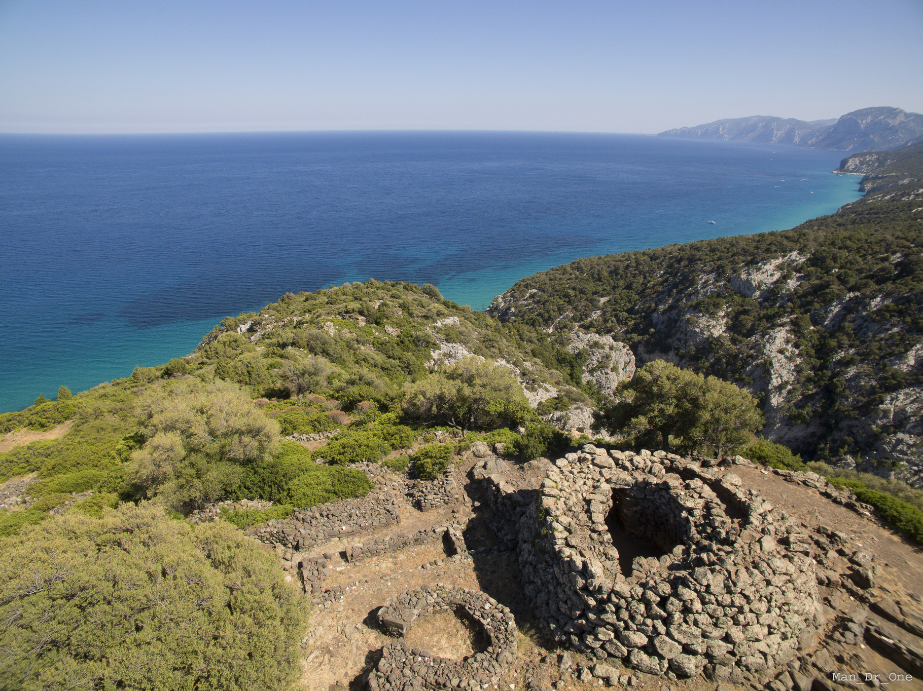
Nuraghe Mannu - Dorgali
The Nuragic civilization developed both inland and on the coast. The archaeological legacies of Dorgali bear witness to how considerably frequented and culturally lively the Sardinian coasts were during the Protohistoric period. The symbol is the complex of the nuraghe Mannu, perched on the top of a promontory, 200 metres above the sea, with its dizzying basalt rock face that descends to the codula of Fuili, a short distance from the Grotte del Bue Marino (Sea Oxen Grottoes) and Cala Luna. The dominant and scenic location was strategic and the view extends across the entire Gulf of Orosei. A path leads up from Cala Fuili close to the archaeological area. It may have been plotted by the Nuragic people in order to reach a nearby landing place. Arriving by car, the diversion leading to the Mannu is at the fourth kilometre along the road that leads to the village of Cala Gonone. From the junction, the nuraghe is two kilometres away and the last 800 metres need to be covered on foot.
The area of the Mannu is made up of a single-tower nuraghe in the centre of a settlement that was first Nuragic and then Roman, stretching for more than two hectares. The tholos tower (false dome) is built with irregular rows of large vulcanite boulders and basalt. It is currently almost five metres high, with a thirteen-metre diameter at the base. The architraved entrance leads into a covered flat arch corridor, which leads first to a stairwell - of which twelve steps remain - and then to a room almost entirely obstructed by a collapse. In the external walls you will notice four niches, probably guard posts, which functioned for sightings and defence of the dozens of huts around the nuraghe. The name Mannu (large) can be attributed to the extensive settlement more than to the monument. The huts near the tower are round and were built with unpolished stones; as you move away, they become rectangular. On the edge of the ravine, the village is protected by a wall that is integrated into the rock. About a hundred metres from the complex lies another settlement, one of the largest of Nuragic Sardinia, su Nuragheddu, with more than 200 huts of various shapes and sizes, not yet excavated.
In the end stages of the Nuragic age, the area was frequented by Phoenicians, Punic people and then by cives of ancient Rome during the Republican and Imperial age. The coexistence of different cultures is evident: the Mannu is the ideal context for studying the final evolution of the Nuragic civilisation and the Romanisation of Barbagia. Roman buildings were constructed over the Nuragic huts, both those for civil use and also warehouses with silos, millstones and storage jars. Each building is made up of two communicating rooms. The walls were built from reused or semi-finished ashlars and the roofs were made of roof tiles and curved tiles supported by a wooden truss.
Antonio Taramelli (1927) was the first person to explore the area. From 1994 to date, a remarkable quantity of ceramic and stone fragments for everyday use have emerged from a long series of excavations - pots, pans, cups, whorls, loom weights, pestles and millstones -, ranging from the Middle Bronze Age to the Iron Age (16th-9th century BC). A stele was also found, implying that there was a Tomb of Giants nearby. Fragments of bricks and ceramics provide proof of the Roman era, while urns from the Late Roman Empire, African terra sigillata with Christian symbols and 4th-6th-century roof tiles are evidence of the site’s Late Antiquity and Byzantine phase: continuity that confirms its strategic placement along the coastal trade routes. A selection of artefacts, from the Protohistoric period to the Early Middle Ages, is on display at the Archaeological Museum of Dorgali.
Mannu and Nuragheddu are two of the countless prehistoric sites in the Dorgali territory. La necropolis of Conca ‘e Janas is one of the most ancient legacies, while other domus de Janas are Pirischè and Isportana. Slightly more recent is the dolmen of Motorra, one of the best-known on the Island. The complex nuraghi that stand out are Purgatoriu and Oveni, located 500 metres from the sanctuary-village, and Serra Orrios, which has one hundred huts, a meeting room, and two megaron temples, making it one of the main Nuragic settlements. The single tower of Gulunie also functioned as a lookout post, close to Cala Osalla. Other Nuragic villages are the 130 huts of the nuraghe Arvu and the most famous of all, that of mount Tiscali. The ultimate Tomb of Giants is s’Ena ‘e Thomes and dates back to the Early Bronze Age.