
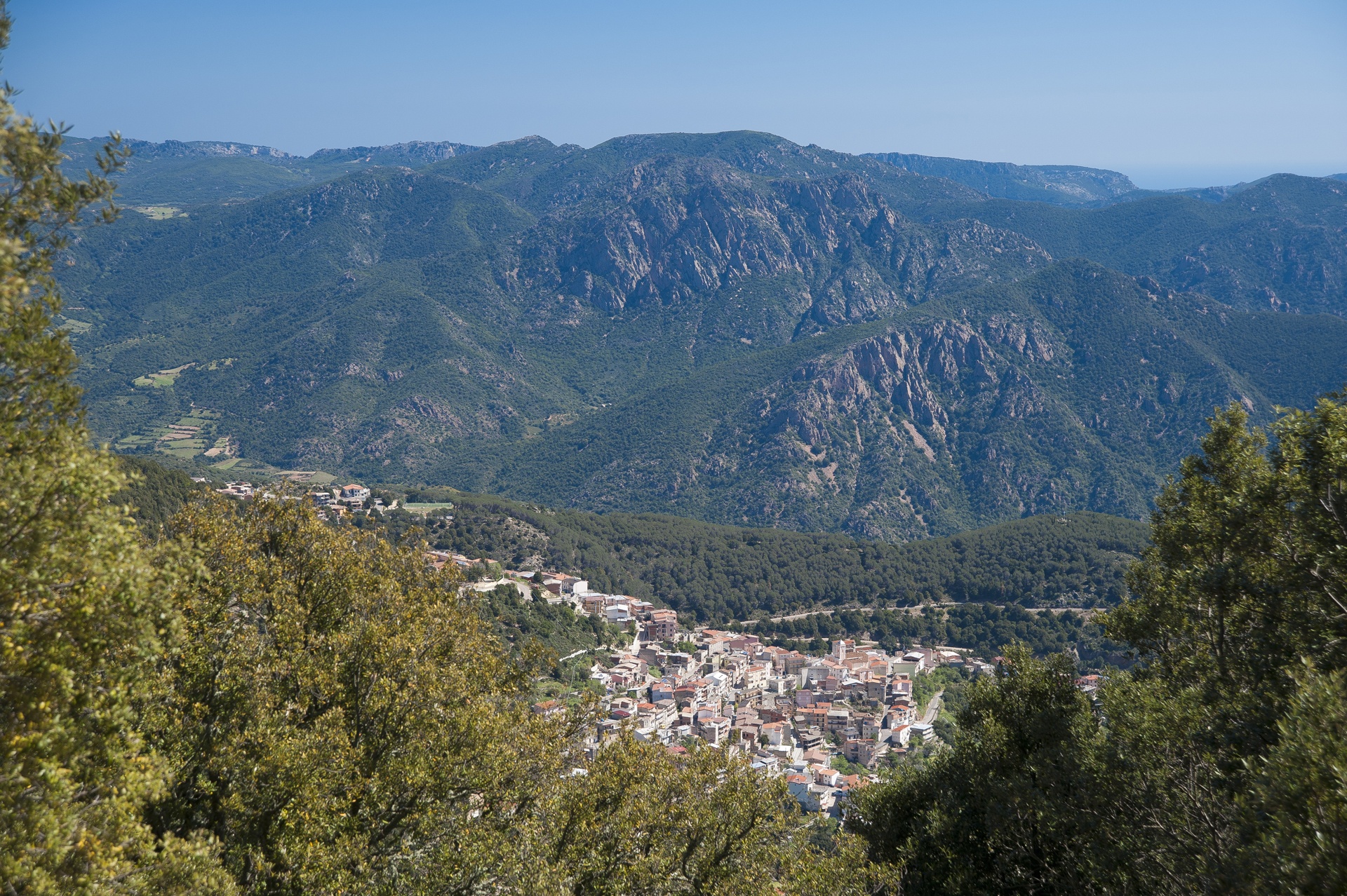
Talana
It is perched at an elevation of 700 metres. Surrounded by woods, it boats a view that spans from Gennargentu to the north-west, to the coast of Tortolì-Arbatax, 25 kilometres to the south-east. Talana is a town of just over 1000 inhabitants in the heart of the Ogliastra territory, the land of centenarians and ‘aging well’, thanks in part to an unpolluted environment, healthy lifestyle and good food. Uncontaminated nature and infinite scenic views are the town’s attractions: it is an ideal place for hiking along marked trails through thick woods and craggy steep, rocky slopes cut by hidden ravines eroded by water, where the more daring visitors can go canyoning through rapids and small waterfalls. Masses of pink granite extending almost 800 meters up the slopes of Mount Mundugia, with its curious trapezoidal shape and impressive gradient, are worth a look.
The town name has Pre-Roman origins, tracing to Thalna (or Thalana), an Etruscan divinity, or to Tàlara (later Tàlana), used to refer to ‘mountainous areas’. A typical mountain town, it perches on some hillocks truncating the steep ridges below the Forest of Funtana ‘e Filigi, which re-emerge further down and continue to the Valley of Coa ‘e Serra. Talana has retained its original layout: narrow, winding alleys linked by frequent stairways and lined with multi-storey houses, some built using grey granite. The network of streets converges at the Parish of Santa Marta. Constructed in early 19th century, it houses 16th century wooden statues. The church is the site of two festivals: the one in late July is called Santa Marta Piccola (little Saint Marta), and the one in early September, Santa Marta Manna (big Saint Marta). In late September, the town celebrates Saint Michele. The church dedicated to him is now gone, but there is a social-cultural centre bearing his name. On the first Sunday in May, a statue of Saint Efisio is carried in a procession to the small country church dedicated to him.
Tradition recipes are based on culurgiones, roasted meat and cheeses. Excellent products arrive from olive groves, vineyards and pastures: olive oil, cannonau and prosciutto, which visitors have the opportunity to taste at the Regional Show/Market of Prosciutto, held in late July/early August. To learn about local crafts, there is the Arti Antiga exhibition. Set up at the house museum in Via Cavour, it includes textile, wrought iron and pottery items, which explore ancient uses and traditions. The area’s wealth of springs and fountains - Gillaoro, s’Orgoese, Sa Carrera and Funtana ‘e Idda in the town alone – has drawn people as far back as Pre-Nuragic times, as seen from the Domus de Janas of Silla Caccari. The area was densely populated during the Nuragic Era: 70 settlements have been found, often on rocky protrusions. The best examples are the village of Praidas at an elevation of over 100 metres and nuraghes of Bau ‘e Tanca and the well-preserved and mysterious s’Arcu ‘e s’Apiargiu (o Lotzorei).
Dorgali
The history, manufacturing arts, the sea, the wild mountains and fragrant woods of the Supramonte will take you to a magical and legendary world. In Dorgali, you will visit an enviable natural patrimony of 225 square kilometres, one of the most extensive municipal territories in Sardinia.
Walking through its distinctive streets, you will see houses made of dark volcanic rock and workshops, where filigree jewellery, pottery and carpet weaving will allow you to discover the village's artisan calling. You can visit the churches of San Lussurio, Madonna d'Itria and the parish church of Santa Caterina. You will travel back in time while in the archaeological museum, which contains artefacts from the Nuragic age (also those of the nearby site of Serra Òrrios) and from the Punic and Roman periods. A few kilometres from the residential area, you can take a trip to the Lanaittu valley and to the legendary Village of Tiscali.
Not far outside the village, in the opposite direction, after passing through a short tunnel, you will see the splendid sightof the Gulf of Orosei, like a real gateway between mountain and sea. Here, you will see true gems like Cala Gonone, Cala Cartoe, Ziu Martine and Cala Osalla, all beaches with golden sand. By boat, or a strenuous hike, you can reach Cala Luna, which borders on Baunei, one of the Mediterranean’s most enchanting beaches. Graced with a beach of almost powdery sand and surrounded by blooming oleander trees it was the setting for the Lina Wertmüller cult film Swept Away. Further inland is the Codula di Luna, a deep gorge of steep walls and ancient juniper trees that have always acted as guardians of the beauty of this place.
Dorgali is famous for the Bue Marino Grottoes, a spectacular 'forest' of stalactites and stalagmites in which there is an underwater saltwater lake and where, during the Cala Gonone Jazz event, one of the most spectacular concerts taking place in Sardinia is celebrated every year. On the subject of marine discoveries, don't miss a chance to visit the Aquarium of Cala Gonone: 25 pools with numerous rare species, particularly loved by children and youngsters.
Cala Fuili
This wonder is worthy of a film and, in fact, appears on the set of ‘Swept Away’ (1974) with Mariangela Melato and Giancarlo Giannini. It is the last cove that can be reached by car or by bike from the renowned tourist location of Cala Gonone, because the road ends at the point in which a descent towards the beach begins. The small, unspoilt, panoramic Cala Fuili, in the territory of Dorgali, not far from the Grotte del Bue Marino, will amaze you with its shallow, incredibly transparent waters and sea with colours ranging from green to turquoise.
Once you have gone down the steps carved out of the rock and crossed a dense wood of shrubs of Mediterranean scrub, the beach, with its white sand mixed with pebbles and rocks emerging from the sea, appears before you.
Your walk will be rewarded by the scenery: the contrast between the green vegetation and the blue sea contributes to the fairy-tale setting of this little cove, along with the rock faces that attract numerous climbing enthusiasts every year. It is very popular with trekking and canyoning lovers –it can also be reached via the evocative internal trail of Codula Fuili - as well as with diving and snorkelling enthusiasts.
Further south, along the Gulf of Orosei, you will find other havens with unspoilt nature and crystal clear waters: Cala Luna and, in the territory of Baunei, Cala Biriola, Cala Sisine, Cala Mariolu and Cala Goloritzè, which will offer you landscapes that warm the heart.
If you are interested in the civilizations of the past, in this area you will be able to go on a journey back in time and visit nuraghi, menhir, dolmen and domus de Janas, or you can delve into the evocative atmosphere of the Nuragic villageof Tiscali. You can also visit the Grotta di Ispinigoli, featuring a 38-metre stalagmitic column, the highest in Europe.

Ilbono
At an altitude of 400 metres above sea level on the southern slopes of the Gennargentu massif, Ilbono is surrounded by a rolling landscape, where the porphyritic rocks of Monte Tarè stand out. Grains, legumes, orchards, vineyards and olive groves are cultivated here, irrigated by the streams that run through fertile hills. Ilbono is a town with over 2,000 inhabitants. In the Ogliastra province, it lies along the ‘road of longevity’ stretching from Lanusei to Tortolì. Since 2005, Ilbono has been an oil city, holding the Sagra di Olio e Olive (oil and olive festival each March that is not to be missed. Another leading sector is artistic craftsmanship. In Funtana de Idda, the main piazza, the narrow and winding historic streets of the village converge. Here stands the parish church of San Giovanni Battista, built in the 17th century on the site of a building that was perhaps Romanesque, whilst the Chiesa di San Cristoforo (the patron saint of which is celebrated at the end of September) was erected between the 17th and 18th centuries. In the countryside, rise up the small churches named after San Rocco and San Pietro, where finds from Roman times have been discovered. The most beloved festival is in honour of the Madonna delle Grazie at the beginning of July. Legend has it that a chest with the statue of the Madonna washed up on the beautiful beach of Cea and was transported to the village. Much beloved are also the rituals of Settimana Santa (Holy Week). Throughout the celebrations, the Ilbono women show off their traditional dress.
The name Ilbono derives from silvone or sirbone (wild boar), due to their abundance during Antiquity. The territory also preserves human remains from the Neolithic period (end of the 4th millennium BC), such as the documented Domus de Janas in various locations, including Tèxere, where seven menhirs were also found, and especially in the archaeological site of Scerì where, in addition to two hypogeal tombs excavated in two boulders (of a monocellular type), a Nuragic complex is maintained, perfectly integrated with the natural context and in a strategic position. On a granite tower stands a Nuragic complex in blocks of granite, consisting of a main tower with a circular layout (almost five metres high) and an added body (48 metres long and 36 metres wide), with an attic below. A village lies in an area that is not as steep. Discovered in some of the huts are materials that provide evidence from the Mid- and Late-Bronze period, from the 15th to the 12th century BC. The Nuragic remains are to be found all throughout the Ilbono territory, one of the highest-density areas of Ogliastra, with a dozen being single-story with megalithic dividers and walls. Some towers have Nuraghi Teddizzò and Mont'e Forru (replete with village). Some have Tombs of Giants nearby, with two in Pèrda Carcina. Indicating the area’s Romanisation are the remnants of an inhabited area, a necropolis and a road in Piranserì and a settlement in Alinusolu. Two military discharge papers were also found: from 79-81 and 127 AD, issued by the emperors Domitian and Trajan.
Arzana
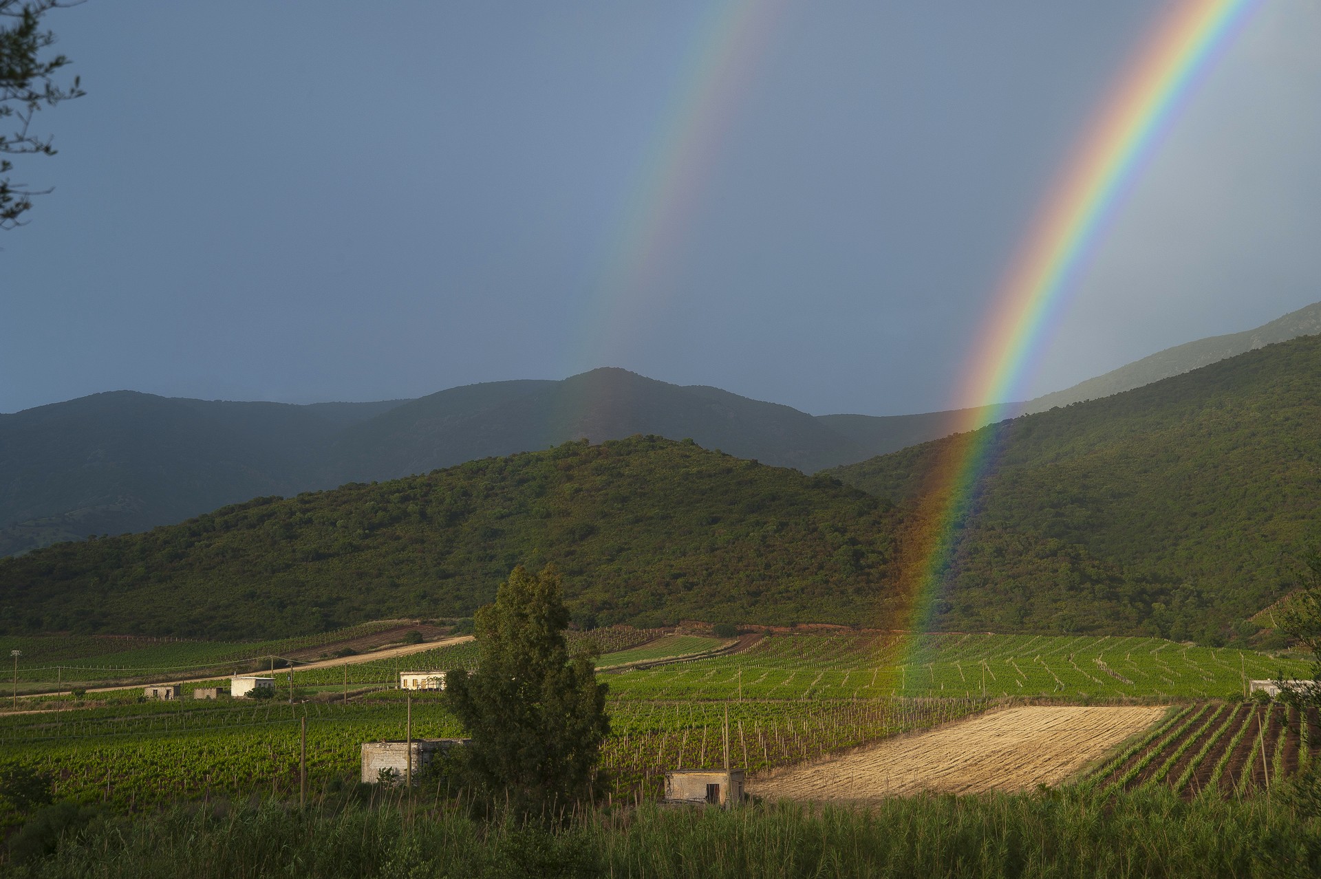
Arzana lies in the heart of Ogliastra, with lush forests and crystal clear springs, at the foot of Mount Idolo, on the slope of the Gennargentu massif, looking out to sea. On clear days, from this part of the massif that, with Punta La Marmora, touches the highest peak on the Island (1834 metres), you can see very distant Sardinian territories. It is an area rich in watercourses that sometimes turn into waterfalls and transparent little lakes: the spring of Funtana Orrubia is not to be missed and nor are the Pirincanis waterfall that flows in a narrow and evocative gorge. In the Flumendosa valleys, stretches of very ancient forests still remain, like the Tedderieddu forest, in particular, where you will find some of the oldest yew trees in Europe, as well as junipers, broom, alders, cistus and holm oaks and where mouflons, wild boar and deer live undisturbed.
The territory of Arzana was frequented starting from the Nuragic age. Bearing witness to this are the Domus de Janas necropolis of Perdixi, the Nuragic complexes of Unturgiadore, Sa 'e Cortocce, Sa Tanca and the village of Ruinas, while in the same area of Tedderieddu, in the village of Silisé and inside the village, at Su Baingiu - where thermal baths were found - ruins from the Roman era were discovered. In the Giudicale period, the village was first under Calari and was then incorporated into the kingdom of Gallura. Lastly, it became part of the Catalan-Aragonese kingdom. Among the religious buildings, the parish church of San Giovanni Battista, rebuilt in the mid-nineteenth century, stands out. Inside it, you will see a medieval cross from Silisé and a seventeenth-century monstrance.
Arzana is one of the symbolic municipalities in the Ogliastra Blue Zone, meaning that it is one of the six areas in the world with the highest percentage of centenarians and elderly people in good health, a unique circumstance studied by the Istituto di Genetica Molecolare (Institute of Molecular Genetics) of the CNR (National Research Council). Longevity, one of the qualifying dimensions of the extraordinary quality of life in Sardinia, is based on the co-existence of genetic heritage, environmental and social well-being and the quality of food. In fact, like the other Ogliastra villages, this one stands out for its delicacies, starting with culurgionis, tasty cheese ravioli that you can enjoy with tomato sauce. In the autumn, during the mushroom season, Arzana gives the best of itself: every year, in November, the Feast of the Golden Porcino Mushroom takes place. You can enjoy this unique experience, reaching the village on the Trenino Verde, a tourist railway line that runs from Cagliari to Arbatax through landscapes of indescribable beauty.
Osini
A town with two lives. The modern-day town of Osini is located a kilometer north of the original one after a flood devastated it in 1951. Old Osini came about in the Middle Ages and was first under the giudicato of Calari, then ruled by Gallura, followed by the Aragonese and Spaniard, but is now a ghost town with empty houses and the XVII church of Santa Susanna. It comes back to life only two days a year in August, when the saint is celebrated. Although modern Osini has only 800 inhabitants, it is graced with artwork done by such Sardinian artists as Maria Lai, Costantino Nivola and Pinuccio Sciola, and blessed by a beautiful mountainous setting of gorges, ravines, steep cliffs and valleys clad in verdant Mediterranean vegetation: there is a woods of oak trees, there are olive groves and vineyards that grow the grapes to make fine cannonau wine.
When you get to the top of the Taccu of Osini, a high plains at an altitude of about a thousand metres, the view you’ll enjoy is over the town itself and all of the Ogliastra, including the lovely Scala di San Giorgio. This gorge is a natural monument set in Sardinia’s most forbidding wilderness: a dauntingly narrow passage between two steep, dolomitic and calcareous walls. The sanctuary in honour of the patron saint, who is celebrated every year on 24 April, was set in this very opening. Legend has it that St. George, bishop of Suelli, read a prayer at the feet of the high plains, which he would have had to either climb over or skirt around, after which, miraculously, a passageway opened in the rock face.
After a short walk, at an altitude of about a thousand metres, you’ll find the Serbissi nuraghe in very good condition. It was inhabited from the Early Bronze Age to the Late Bronze Age (XVII-X century BCE). and is now an archaeological park where thousands of years of history and natural beauty blend seamlessly: the buildings, a rare example of a nuragic complex on high ground, stand out over a panorama of calcareous cliffs with steep walls, on which they sit by means of an unusual technique of terracing. The structure, one of the most important of the Nuragic civilization to have reached us, is made up of complex nuraghes with four towers, a village, cave, two giant tombs and, not far away, two single tower nuraghes, Sanu and Orrottu.
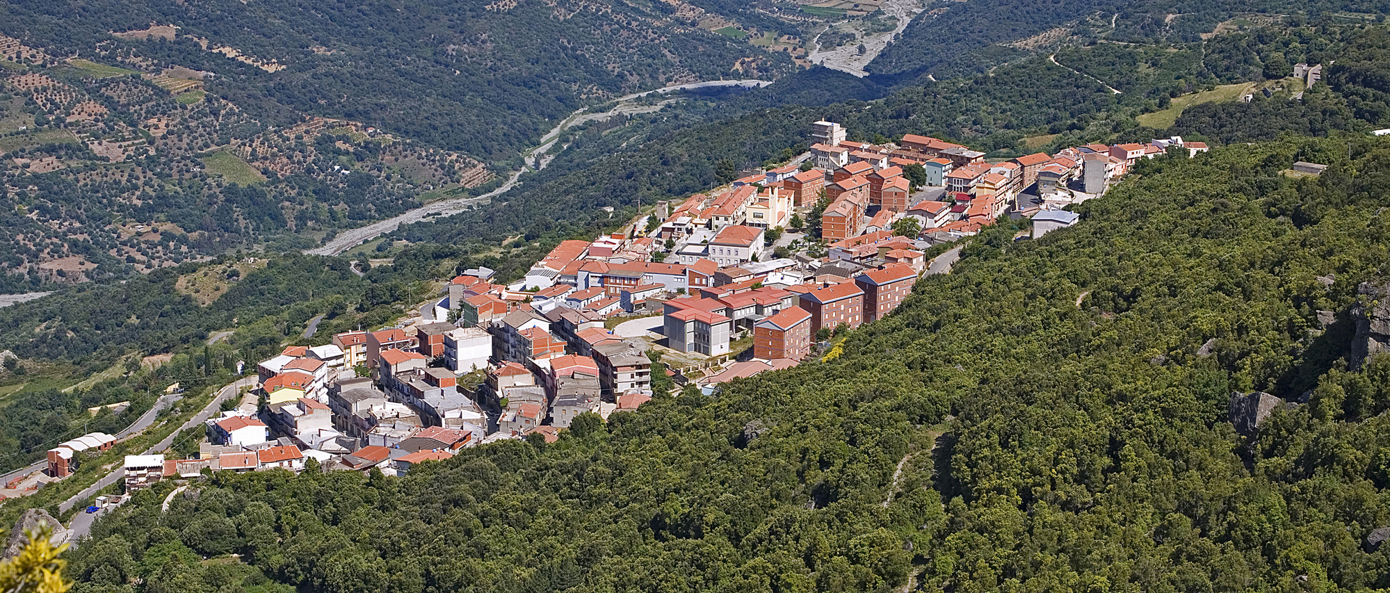
Elini
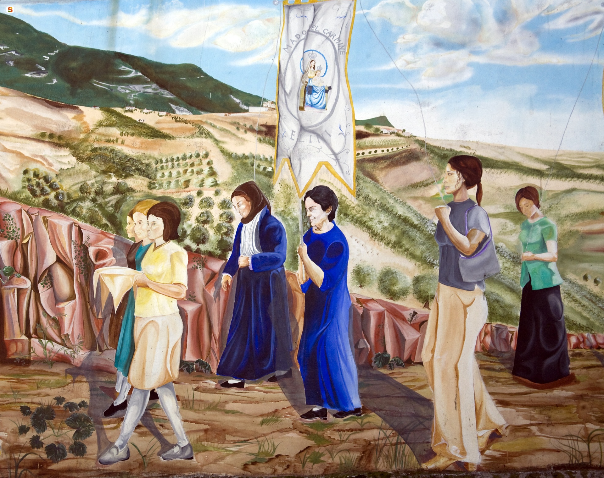
Halfway along the road, between the blue Ogliastra sea and the rugged Gennargentu mountains, the smallest village in the Ogliastra region is perched at a height of almost 500 metres. Elini, which has about 600 inhabitants, extends along a valley covered in centuries-old olive trees, protected from the predominant northwesterly Mistral wind in these lands by the tall mountains. Its territory is filled with numerous springs, which make the area very fertile: olive trees, vineyards and orchards grow here, and there are also holm oaks and downy oaks. The most evocative means of transport to reach this place is the train: accompanied by the soft sound of the wheels on the tracks, you will travel through enchanted landscapes, between limestone 'buttes' surrounded by the lush nature. Once you reach the centre of the village, you will descend into the old station, built in the nineteenth century from granite blocks. In the old town centre the parish church of San Gavino Martire is worth visiting. It was built in the 20th century on sixteenth-century foundations. In the upper part of the village, you can enjoy a spectacular landscape and you can walk between holm oaks and continuous springs: the Parco Carmine park is located here and is a must during your visit. Inside it, you will also find the ruins of two Nuraghi and, above all, you can admire the beautiful sanctuary of Madonna del Monte Carmelo, dating back to the 17th century. According to the canon Flavio Cocco, the origin of the little village is linked to the park. Here, in Antiquity, a Roman military garrison apparently installed itself here. The Elini people venerate the warrior saint Gavino, celebrated solemnly every year on 18 May, and this points to the military origin of the place. The most heartfelt festivity, however, is in July, with celebrations and processions taking place for three days.
Marina di Cardedu
Eight kilometres of beaches, one of the longest on the Island, where stretches of light sand alternate with brighter-coloured pebbly sections. The Marina di Cardedu is a very long coastline in southern Ogliastra, protected by an expanse of eucalyptus trees behind it, overlooking the clear sea reflecting shades of blue and emerald green. Thanks to its considerable size, the coast is never too crowded, not even in high season, while its position means is exposed to the sirocco winds, making it a destination for surfers. The sea quickly becomes deeper and is ideal for diving and snorkelling. The surrounding landscape is wild and captivating, with the hills of Monte Ferru standing out in the background, covered with Mediterranean scrub and sloping towards the sea with spectacular cliffs.
To the north of the Marina di Cardedu lies the beach of Foddini with sand that has golden reflections and an unusual lake next to it. Even further north, without interruption, the coast of Barisardo begins. To the south, beyond the main beach of the marina, is Museddu, where the sand is just as light but a little coarser. The blue reflections of the sea and the greenery that surrounds the coast create an enchanting colour effect. The wide beach allows for relaxing walks and horse riding. The deep waters are frequented by underwater fishing enthusiasts. Continuing further south lies the beach of Perd’e Pera: here, red porphyry rocks start to decorate the landscape, the sand is white and fine and the sea offers shades of blue and emerald green. Behind it, the eucalyptus pine forest provides shelter during the hottest hours. On the beach, you will find all the services you need, bathing establishments, refreshment areas and small boat hire.
The reddish cliffs become clearly dominant on the border of the Marina di Gairo, with wild stretches and breathtaking coves: the last stretch of Cardedu is la spiaggetta, with its dark pebbles and rocky outcrops; then come the charms of Gairo Sant'Elena, Su Sirboni and Coccorocci. The first, at the end of a path nestled in the scrub, will offer you soft, light sand and a turquoise sea with shallow waters. The second is a triumph of colours: multi-coloured pebbles, deep blue water, red porphyry rocks and lush junipers.
Tertenia
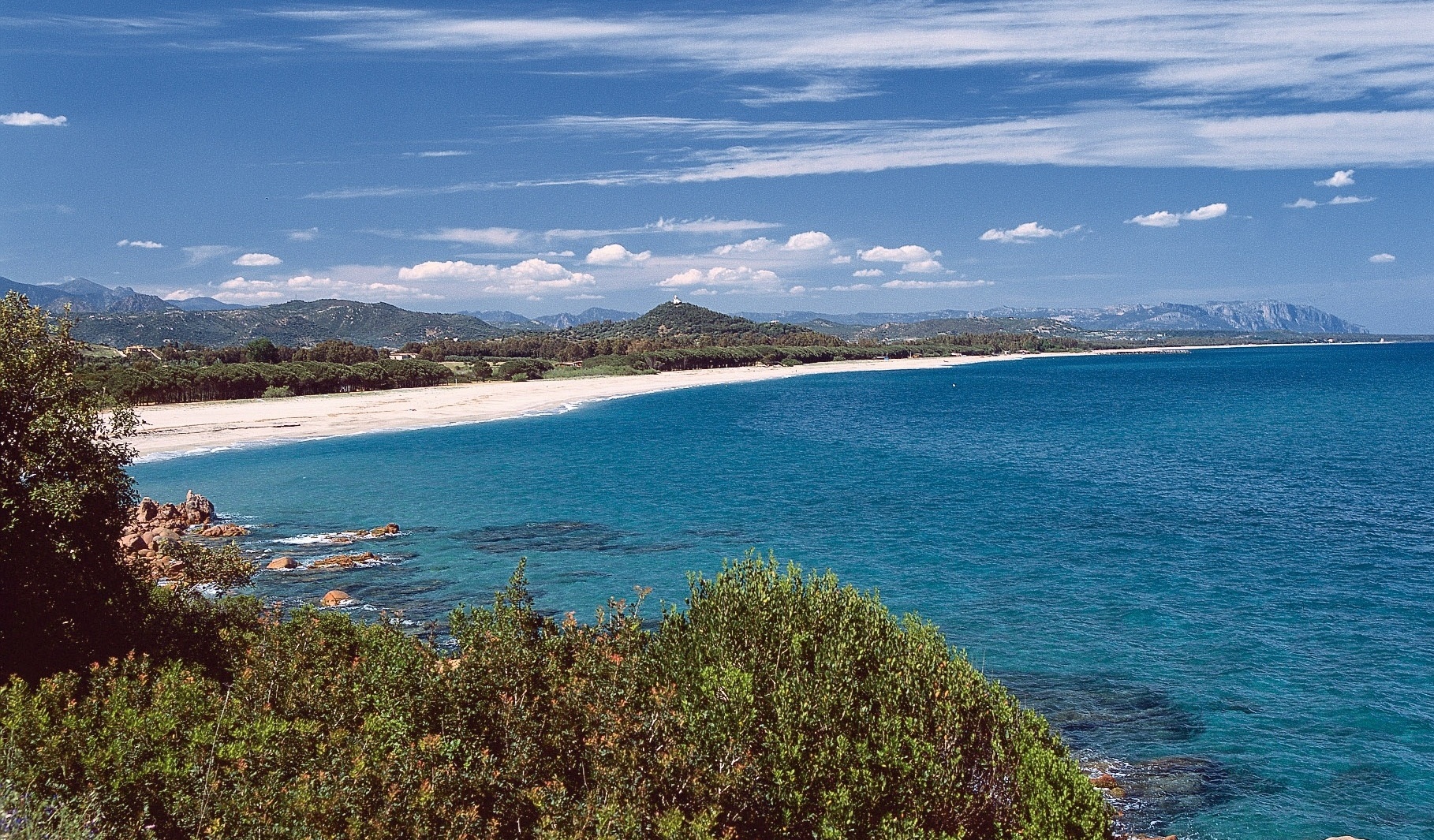
Fascinating landscapes of the sea and the mountains. A hundred kilometres from both Cagliari and Nuoro, Tertenia is a village with an agricultural and pastoral tradition in the southern part of Ogliastra, populated by almost four thousand inhabitants. It stands in a valley, surrounded by the complex of Monte Ferru, rich in forests and trails, from the Taccu mannu and from Mount Arbu. The scenery is striking: the waters of the Rio Quirra torrent, which crosses through the residential area, and its tributaries, vineyards and holm oak forests of Crabiolu, Fustiragili and Bingionniga, create colour variations ranging from blue to green. In the background, the limestone towers of Tacchi d'Ogliastra add even more charm. The coastline stretches for twelve kilometres. The long Marina di Tertenia consists of enchanting beaches of soft, light sand, interspersed with rocky shorelines: Foxi Manna, Foxi de Murdegu and S Abba de Is Marronis. Their waters are transparent and iridescent blue.
Next to the coast, there are plains and hills with lush Mediterranean scrub: cistus, strawberry tree, mastic and heather. Overlooking Foxi Murdegu, there is the tower of San Giovanni di Sarrala (16th century). According to tradition, the village first emerged here, by the sea, and it then moved higher up, in order to defend itself from the Saracen incursions and, in the end, it settled in an 'intermediate' site. Confirming this, is the fact that Sarrala comes from the Roman town of Saralapis, which may have been located here. Between the end of the 19th and the beginning of the 20th century, the area was involved in the extraction activity of minerals transported and loaded in the port of Santoru, in the southernmost part of the Marina.
The first traces of a settlement in the territory of Tertenia date back to the Late and Final Neolithic periods (4th-3rd millennium BC), in the grottoes at the foot of Mount Giulea and the Domus de Janas necropolises in the localities of Magalàu and Santa Lugia. In the Bronze Age, the village was densely populated: almost 80 Nuraghi - among which the Aleri Nuraghe stands out - about thirty Tombs of Giants, about twenty Nuragic villages and a sacred well. From archaeology to art: in the village, there is the Albino Manca Museum, dedicated to the very successful artistic experience (in Italy and in the United States) of the painter and sculptor who was born and died in Tertenia (1898-1976). Among the religious buildings worth visiting, there is the parish church of the Beata Vergine Assunta and the church of Santa Teresa d'Avita (17th century). In Bidda 'e Susu there is the Byzantine church of Santa Sofia, in honour of whom the most heartfelt festivity is celebrated (beginning of September). There is a costume parade in honour of San Pietro Apostolo, while in August there is a feast of typical local produce, in which you can enjoy roast and boiled sheep, cheese and local wines.
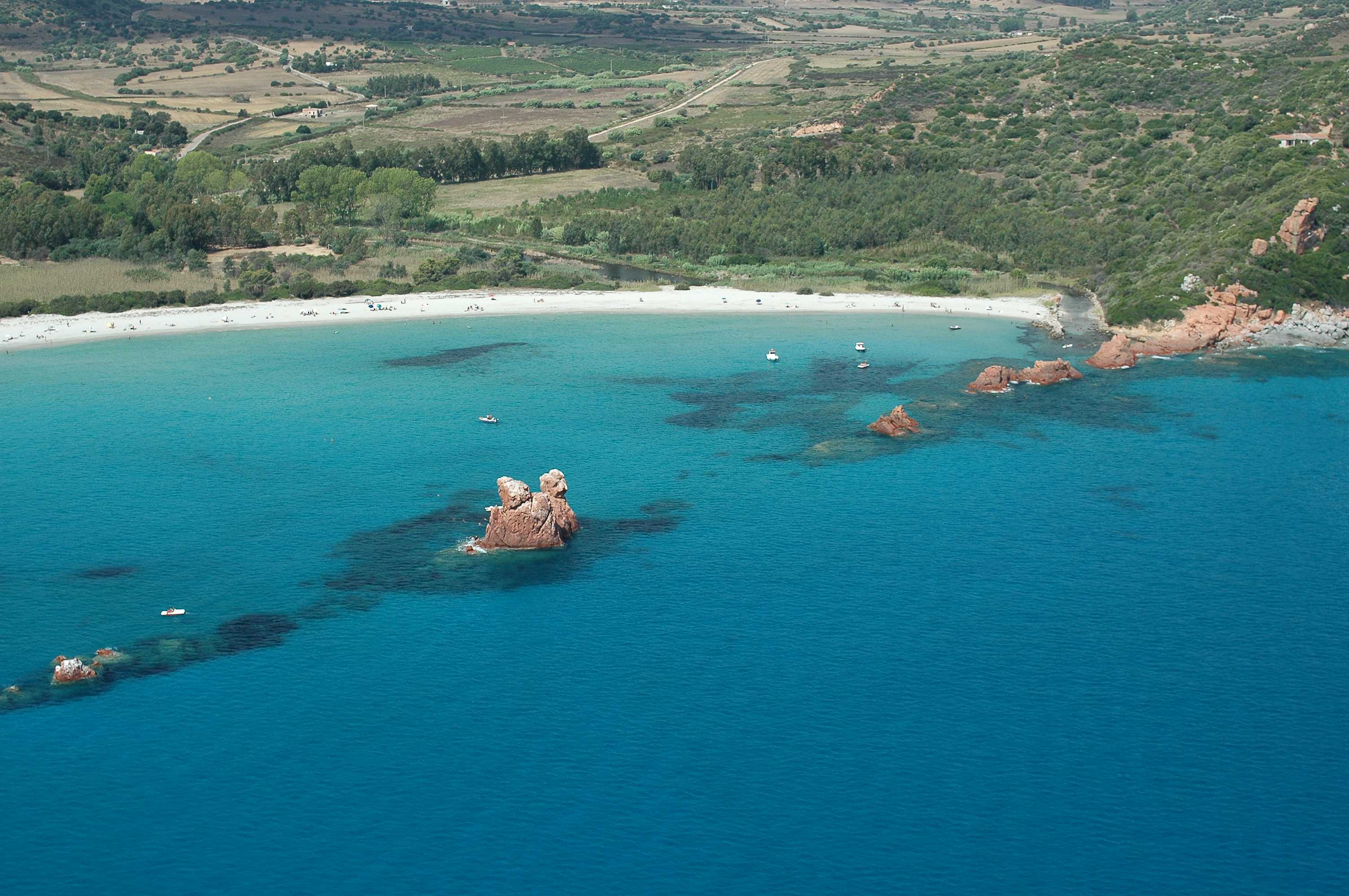
Cea
Soft, white, weightless sand, shallow waters, smooth rocks and the sunlight highlighting the emerald green nuances of the sea. The beach of Cea is more than a kilometre long. Three quarters of it belong to the territory of Tortolì, a town just a few kilometres along the coastline of Orrì, and the other quarter is on theBarisardo coast, which is about seven kilometres away. To the south, it is delimited by a row of rocks, Punta Niedda, while a little further on, there is the volcanic rock of the Plateau of Teccu. Walking here is a sensory experience: the sand is silky to the touch, the scent of the junipers and Mediterranean scrub, the sounds of the sea and its colours all make it a memorable part of your holiday.
From the nearby hill, a ridge of red porphyryends as a beach. In the same direction, 300 metres from the shore, in the centre of the coast, two twenty-metre high sea stacks appear: Is Scoglius Arrubius, which lights up at sunset in a spellbinding show of colours. They are the symbol of Cea, and you can swim to them or reach them on a pedalo.
The beach has places for dining/refreshments, ample parking and equipment rental. There are also services for the disabled and walkways that lead to the water. A little way beyond the beach, a small cove with rocks and stones makes it possible for pleasure boats to dock there. Behind it, there is dense vegetation and next to it there are little ponds, linked to the sea during high tide, where you can fish for grey mullet.
Heading north, in the territory of Tortolì, you will find another picture-postcard location, Lido di Orrì, 16 kilometres of coastline consisting of little coves and small deserted beaches, among which the splendid Cala Ginepro. Then, in the territory of Barisardo, you can visitthe beach of Torre di Barì, symbol of the municipality located in the Ogliastra area. On the subject of red granite, near Arbatax, which is a district and port of Tortolì, don't miss a chance to admire the beach of the Rocce Rosse(Red Rocks), which act 'as a shield' to another dreamlike area, the 'city' beach of Cala Moresca.