

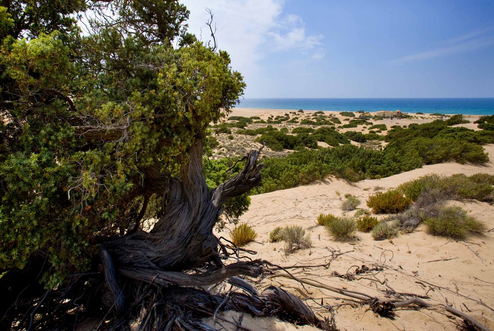
Putzu Idu
A narrow and curved strip with very fine grains of quartz, almost two kilometres long, separates the turquoise sea from the Sa Salina Manna pond. It is the splendid beach of Putzu Idu, called 'Cala Saline' and sheltered from the northwesterly mistral wind, which extends to the north of the magnificent S'Arena Scoada and extends as far as the beach of Mandriola. The quartz sand is soft and white. The waters offer evocative shades of green and blue that vary according to the light. The seabed is sandy and the waters are shallow for tens of metres.
Putzu Idu is located at the northernmost extremity of the marine area of the Sinis peninsula, just below Capo Mannu, in the territory of San Vero Milis, which is about twenty kilometres away. On the beach, you will have places for dining and refreshments at your disposal, as well as beach equipment rentals and the opportunity to go on trips to the island of Mal di Ventre, located alone in the southeastern area of the promontory. In the tourist centre behind it, all necessary services are available. As in the whole of the Sinis area, there are often waves, making it very attractive to kitesurfing and windsurfing enthusiasts. Behind the beach and the residential area, there is Sa Salina Manna, a pond and the habitat of protected flora and fauna, including the greater flamingo in the springtime.
Going back along the cape, you will come across the beach of Mandriola, that closes the curvature created by the bay of Putzu Idu: It is a small sandy shore with soft, light sand and crystal clear water. Continuing on towards the tower of Capo Mannu, known as Sa Mora (mid-17th century), you will meet another two splendid little coves: Sa Figu and Dei Tedeschi. The first is a small stretch of amber-coloured sand, set in between the rocks and a popular destination with numerous surfers. The other gets its name from a dock that served as a refuelling place for German submarines during the Second World War. Today, it is famous for scuba diving. On the other side of Capo Mannu, don't miss your chance to see Sa Mesa Longa and Su Pallosu, another two gems of the Sinis peninsula.
Marina di Arbus
A large expanse of fine golden sand, two kilometres long, delimited by a cliff dotted with Mediterranean greenery, which you can reach via a downhill path, dug out of the reddish rock, demarcating the sandy shore. Marina di Arbus, is a symbol of the Costa Verde and it is about 25 kilometres from the town of Arbus. The water is crystal clear and blue, but its colours are often iridescent due to the refraction of the light on the seabed, which slopes gently, making it safe for children to play there.
The melody of colours, made up of the blue of the sea and the deep green of the broom, strawberry trees, myrtle and juniper, which cover the dunes behind it, often lead to it being referred to as the 'Caribbean in Sardinia'. The windswept beach is a popular destination for surfing enthusiasts and also for those who enjoy underwater fishing or snorkelling.
The Costa Verde sea is spectacular and wild. The sand dunes are a characteristic of the whole territory of Arbus, which has three pearls symbolizing Sardinia: Torre dei Corsari, a haven shaped by the wind, Piscinas, a sandy desert washed by the emerald green sea, and the 'talking' beach of Scivu (due to the sound made by the sand when you walk upon it). Other wonders of Arbus are Funtanazza and Portu Maga. At the southernmost limits of the Costa Verde, you will find the spectacular Capo Pecora, a popular destination for scuba divers and fishermen. On the northern border of the Arbus coast lie the two kilometres of Sabbie d'Oro (Golden Sands) of Pistis. While, just behind the shoreline, you can travel back in time, into the industrial archaeology represented by the evocative mines and mining villages of Ingurtosu and Montevecchio.

Portu Maga
A captivating setting will appear before your eyes: a combination of the deep blue colour of the sea, the golden sand, the multi-coloured rocks and the green ‘carpet’ of Mediterranean scrub covering the hills in the background. You will reach Portu Maga, a tourist village in Arbus that emerged in the 1990s, as you travel along the coastal road from Piscinas towards Marina di Arbus, two of the most gleaming ‘pearls’ of the Costa Verde. It stands on a hillside overlooking the sea: from here, you can gaze freely at the spectacular views and sunsets. Its coastline stretches for three kilometres, with a large, relaxing beach, where short stretches of the sandy part are interrupted by flat rocks.
The warm, medium-grained golden sand is washed by the crystal clear water with its beautiful colours becoming more intense on calm days, thanks to the reflection of the sun on the shallow water and the sandy seabed. A few rocks emerge here and there, in an environment full of life, with fish, molluscs and marine flora, ideal for lovers of diving and recreational fishing. An unusual feature is the abundance of the famous Bolma rugosa shells, with their mother-of-pearl sheen, known as the ‘eyes of Saint Lucia’. The beach offers a large car park, plenty of refreshment areas, bathing equipment and boat rentals (canoes, pedaloes and rubber dinghies). In the surrounding village you will find accommodation facilities, holiday homes, a few restaurants, a shopping area and services, especially for families with children.
You will feel the wild and slightly retro charm typical of the area: along with Torre dei Corsari, another paradise shaped by the wind, further north you’ll find Portu Maga, the only tourist village on the Arbus coast. It is right in the centre of the splendid Costa Verde, almost 50 kilometres of long, wide beaches, true deserts with sand dunes - Torre dei Corsari, Piscinas and the ‘talking’ beach of Scivu -, interrupted by rocky coves and sheer cliffs overlooking the sea. The spectacular, wild sea is rarely calm, making it daunting and sometimes hostile. At the extreme tips of the coast, you’ll find Capo Pecora to the south, a popular destination for divers and fishermen, and other dunes to the north, the Golden Sands of Pistis. The wonders closest to Portu Maga are the beautiful Funtanazza, an innovative tourist resort, and Marina di Arbus, a large expanse of fine, golden sand, two kilometres long, surrounded by Mediterranean vegetation and junipers.
To get to Portu Maga, you can also take the provincial road SP 68 and, before diving into the sea, treat yourself to a look at the abandoned sites and uninhabited mining villages of Montevecchio (in Guspini) and Ingurtosu (Arbus), captivating examples of industrial archaeology.
Castello di Medusa
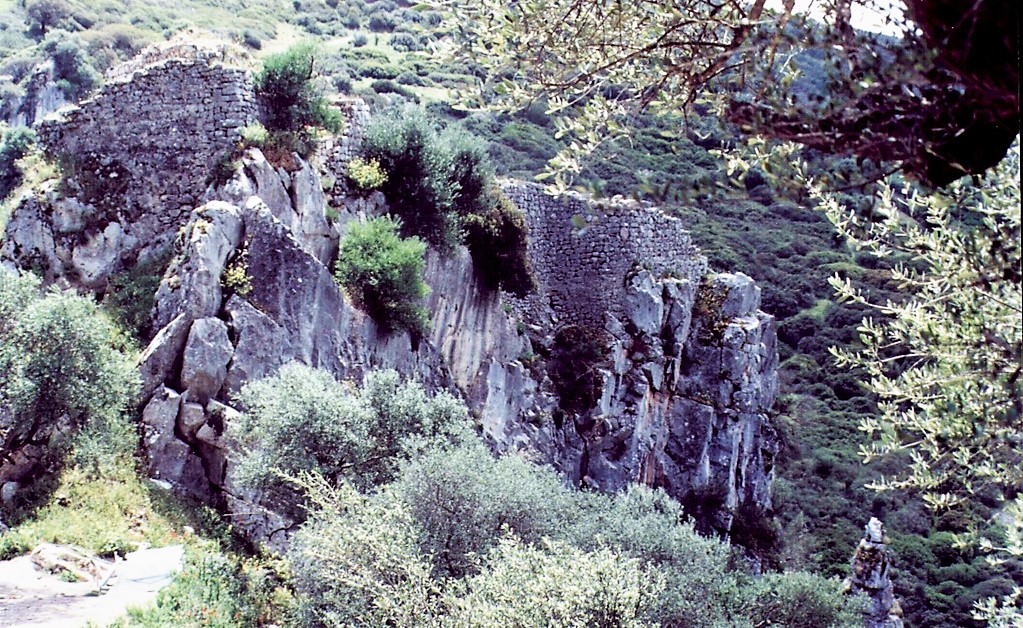
Distant and almost inaccessible, the castle of Medusa has left few traces in history, almost as if it never existed. In contrast, it is the subject of infinite imaginative legends. This mysterious rock, surrounded by solitary hills, ravines and crevasses is set in an impervious landscape where falcons nest, riven by mountain torrents and ancient woodland, domus de Janas and nuraghes. It clings to the hillside of sa Conca 'e su Casteddu, on the edge of the rocky ravine formed by the riu Araxisi river with its limestone cliffs covered in greenery and ridden with caves. The location falls under the territory of Samugheo, an equal distance from the "carpet town" and Asuni, in the heart of Mandrolisai. It is an "anomalous" castle, built at the bottom of the valley, almost hidden, placed to control the traffic from the "Romanised" plains near Forum Traiani to the hills of Barbaria, inhabited by rebel populations.
Once the only road to the Barbagia region passed beneath the fortress, which can now be accessed by a narrow, asphalt road that brings you within 500 metres. From there, continue on foot (or in a jeep) along paths through the woodland that run right up to the castle, It was built during the "Lower Empire" (4th-5th century AD) as a Byzantine castrum, and was later modified twice, in the 6th and the 7th-8th century. The rectangular layout, western battlements and two towers, one with a cistern, date back to the first construction phase. The eastern battlements were built between the 10th and 11th century, when it became a frontier castle between two jurisdictions. The walls, which are now overgrown ruins, originally enclosed an area of around 540 square metres. The castle is first mentioned in a document from 1189, which talks of a castrum Asonis transferred to Genoa by the Judge of Arborea; in 1389, it was restored by Judge Eleonora. The name "Medusa" arrived only after 1480, and it was also known as "di Giorgia". Medusa was an ancient Sardinian pagan goddess. Spano talks about her "home" in the archaeological Bullettino (1860), describing it as home to ghosts and demons, with walls two metres thick, a tower saved from treasure hunters, and caves and rooms dug out of the rock. In legend, it is an enchanted place full of treasure, built by Phorco, who came from Africa to proclaim himself King of Sardinia. When he died (253 AD), his daughter, Princess Medusa, reigned for 28 years: she was an intelligent, warrior-like woman who was the most beautiful on the island, as well as being a jana who could work magic. She died in battle, killed by Perseus, and left the castle and its treasure to the devil, protected by the souls of those who had guarded it, who would transform anyone arriving into blocks of stone. The castle's treasure frequently features in the stories about it, such as an episode that is midway between history and fantasy form the mid-19th century: an Asuni bandit named Perseu (coincidence!), sentenced to seven years in prison in Genoa, told that when evading capture he had hidden in the castle, and found himself in an amazing room full of jewellery, weapons and valuables. He was granted permission to return and find the treasure in exchange for a pardon. Once in Sardinia, no room or treasure was found; nonetheless, locals continue to believe it exists, closed in chests and protected by lethal magheddas flies. In other late-Medieval "chronicles", Medusa is confused with other popular figures such as Maria Cantada and Luxia Arrabiosa.
Paulilatino
Surrounded by cork oaks, Mediterranean shrubs, olive groves and vineyards, and irrigated by springs, it sits in the south of the basaltic plateau of Abbasanta. Paulilatino, the biggest town of Guilcer in the Medieval period, has 2300 inhabitants, offers uncontaminated scenery and is famous for its prehistoric sites: Domus de Janas, dolmen, menhir and as many as 110 Nuragic sites. The most important of these is the Temple of Santa Cristiana (12-8th century BC), the best preserved and fascinating example of Nuragic holy architecture. It stands in a park with hundred-year-old olive trees that takes its name from the 11th century country Church of Santa Cristina. The Well Temple, surrounded by a fence shaped like a lock, has a vestibule and staircase covered by architraves and a chamber with a tholos vault. Water enters the pool through a year-round spring. Outside the fence, there is a meeting shed and a dozen or so other buildings, possibly housing for priests and market stalls. Two hundred metres away, stands the Santa Cristina Nuraghe, six meters high and thirteen wide. Sheds occupied from Nuragic age to the Medieval lean against the structure. Other must-see nuraghes include Battizzonis with a keep, bastion and three towers, and Lugherras. Built between the middle and the end of the Bronze age, it has a central tower surrounded by a three-lobed bastion, which is surrounded in its turn by an external wall with four towers. Nearby, there is a Giant’s Tomb with rare four-cornered stele. During the Punic-Roman period, a temple dedicated to Demeter and Kore was built on the summit of the nuraghe. Excavations brought to light various votive oil lamps (lugherras), for which the site was named. The most important Giant’s Tombs are those of Goronna. One of these, at 25 metres long, is among the biggest of the island. The “block-type” Mura Cuada Tomb is also interesting.
Paulilatino’s main income is from shepherding, which produces excellent cheeses: caciotta, sweet paulese and musinau (a type of sheep milk cheese). Ancient knowledge possessed by the locals is related to weaving and bread baking, for normal days (su coccoi de tzicchi) and for the holidays (su lazzaru). You can learn about local traditions at the Ethnographic Museum hosted at the Atzori mansion: the life of a community of shepherds and farmers is portrayed through old furniture and work tools. During the Roman era, to which the tombs of Muriscoa and the ruins of Putzu ‘e Turru have been attributed, the village was called Paulis Lactea. The name derives from a nearby bog, drained in 1827, which in the spring formed a milky film, latina in Lugodorese. Low, black basalt houses with ‘Aragonian’ doorways and wrought iron balconies, give the town a fairy-tale feel. The main square is called Su Pangulieri, meaning market stalls or the place were outlaws were punished. Here stands Su Cantaru Mannu, a large fountain fed by the Sa Bubulica spring. Many other springs powered mills until mid-20th century. In the town centre stands the 16th century Parish of San Teodoro built in the Catalan Gothic style with a façade embellished by a rose window and a bell tower with an onion dome. Other religious buildings include the 17th century churches of Anime and of Santa Maria Maddalena, in honour of which the most popular celebration is held in late July, the 16th century cemetery Church of San Sebastiano and the Church of Nostra Signora d’Itria, whose feast day is celebrated after the Pentecost with a procession in traditional dress and sacred songs, is goccius.

Mogoro
Mogoro is synonymous with the art of textiles and woodworking, crafts renowned the world over and with roots set deep in history. In the mid-XIX century, the sound of 600 looms acted as a rhythmic backdrop to daily life, and still today it is a tradition kept very much alive. The rural town is in the upper Marmilla and boasts 4,500 inhabitants. It is known for its rugs, tapestries, traditional dress, wedding chest covers, is fanigas (for on top of the chests), is cannacas (ox collars), chairs and trunks, and for the fine wine made by the local cooperative. Every summer since 1961, visitors from all over Europe flock to the Sardinian Artistic Crafts Fair.
The town sits on an plain on the southern slope of Monte Arci, 35 km south of Oristano. A region steeped in history, it was the Mediterranean seat of obsidian processing in prehistoric times. The fertile land, the harvests and milling of grain have given the local bread and baked goods (civrasciu, coccoi, malloreddus and fregola), as well as sweets (pan’e saba, pabassini and pardulas), a distinct technique and character. Artisanal workshops alternate along the streets with basalt homes graced with lime window frames and wooden doors. In the centre is the church of San Bernardino da Siena, a late Romanesque building with baroque touches. It has a single nave with frescoes depicting the life of St. Bernardino and is home to a relic of the 1604 miracle of the Eucharist. The Romanesque-Gothic church of the Carmine was built in the early XVI century and belonged to the Carmelite monastery until 1855. In a medieval village destroyed by the Saracens in the XV century is the church of Santa Maria Carcaxia. Although it has been rebuilt various times (the last renovation was in 1921) it seems to have been originally constructed in the year 1000. Its walls are of white stone and basalt and it is surrounded by vineyards and olive groves. The ancient church of Sant’Antioco was built with the same materials on a nearby hilltop and can be reached along panoramic stairs. You can enjoy cultural-archaeological excursions surrounded by nature. The oldest of the area’s remains date to the Palaeolithic Age. The vases from the Ozieri culture date to the late Neolithic Age and were found at various sites. The pre-Nuragic settlement of Puisteris contained material from the Bonu Ighinu culture. There are 27 nuraghe, 13 single-tower ones, like su Gunventu, and 14 complex ones, as well as the Cuccurada archaeological site (open to the public) featuring a multi-lobed nuraghe built over an earlier corridor version, a protective wall from the Copper Age (2400-2100 BCE) and a megalithic structure of uncertain purpose. Its floor plan is what makes this nuraghe unique. The four towers of the bastion are connected by a wall that encircles a pentagonal courtyard where the remains of huts were identified. The digs uncovered relics that date from the Late Bronze Age to the early Iron Age, reused in the Middle Ages.
Oristano
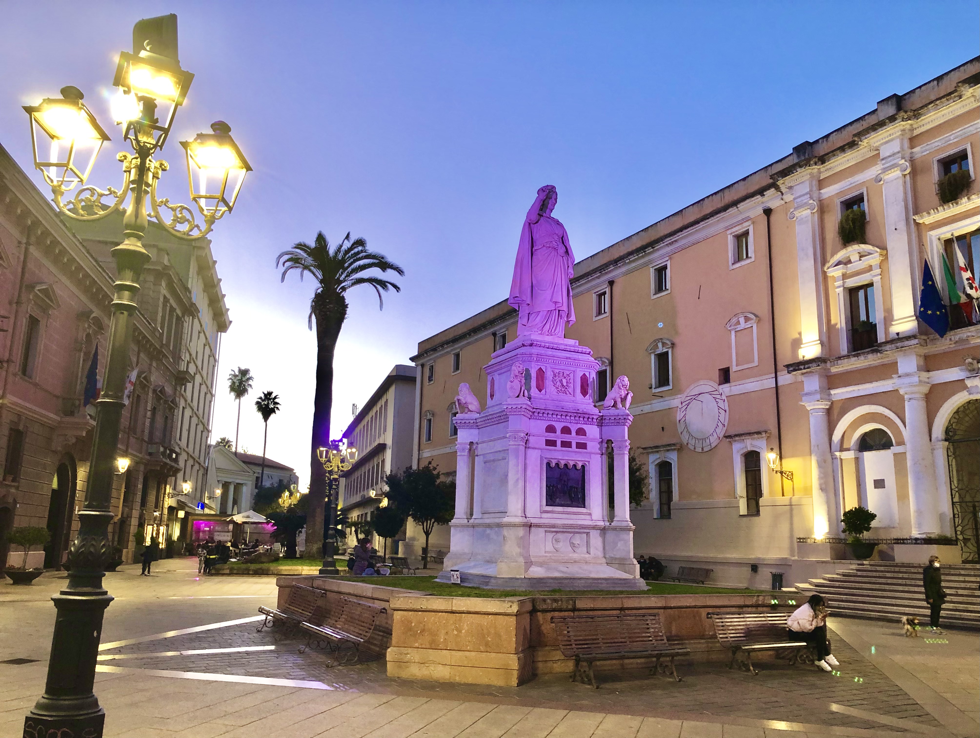
An event that is eagerly awaited all year long: all of Oristano's charm comes out on the occasion of the equestrian joust of sa Sartiglia, symbol of the of the city's traditions: Sunday and Shrove Tuesday of the Carnival period attracts visitors from every part of the world. The ceremonials of the event evoke the glorious past linked to the corporations. The town's history is relived during the festivity, along with the taste of the almond cakes and the typical local Vernaccia wine.
The role of Oristano has been that of a protagonist in Sardinia's history: from the 11th century, the town centre started to be embellished with palaces, fortifications, towers and religious buildings. In the spotlight, there is the majestic Tower of Saint Christopher - also know and the Tower of Mariano - and the Monument of the Giudicessa Eleonora (1881), who promoted the Carta de Logu, one of the first codes of law written in Europe. Also worthy of a visit is the Antiquarium Arborense museum, located inside Palazzo Parpaglia, where you will admire artefacts from the excavations of Tharros, and the churches of San Francesco, in Neoclassical style, Santa Chiara, a rare example of Gothic style on the Island, and the cathedral of Santa Maria Assunta (built in 1130).
After a day of admiring the monuments and lunch consisting of malloreddus with sausage and, for dessert, mustazzolus, a walk in Torregrande, Oristano's beach par excellence, is perfect. In the bordering territories, you will find the splendid beaches of the marine area of the Sinis peninsula, with grains of quartz (Mari Ermi, Is Arutas and Maimoni) and fine sand (san Giovanni), the limestone promontories and the beautiful beaches near Putzu Idu and, further north, the evocatiive natural monument of s’Archittu.
The territory around Oristano is characterized by numerous lagoons, among which those of Cabras and Santa Giusta, the habitat of numerous rare bird species. The wetlands represent one of the area's resources: the fishing industry, along with the confectionery industry, wine-growing sectors and excellent artisan ceramics, wood and wrought iron, all represent not only the basis of the local economy, but are also attractions for visitors.
Marrubiu
Its name apparently comes from a plant, typical in the Campidano area, once used as for medicinal purposes. Marrubiu, a village with almost five thousand inhabitants, is located fifteen kilometres from Oristano in one of the most fertile areas on the Island: it has been a centre of agricultural production for centuries and one of the most spectacular carnival events in Sardinia is celebrated here: Su Marrulleri. The village emerged from the village of Zuradili in the 11th century, the inhabitants of which moved to Marrubiu at the end of the 14th century. Legend has it that they had left behind a little statue of the Virgin Mary in the village. For this reason, still today, a procession of knights and traditional floats travels from the parish church of Vergine di Monserrato, every year at the beginning of May, accompanying the simulacrum into the church of Santa Maria di Zuradili, reconstructed in the first few decades of the 20th century. The little rural church is located on the slopes of the Mount Arci Park, which is partly in the territory of Marrubiu.
The history of the village is inescapably linked to the mountain's 'black gold': deep inside the mountain lies the largest deposit of obsidian in the Sardinia. The massif, with its green ‘coat’ of cork oaks, downy oaks and Mediterranean scrub and covered in lava flow, has three peaks, which were originally three volcanic ducts and bring to mind the image of a tripod. The forests are populated by mammals, among which deer and fallow deer, and also birds, like the northern goshawk, the Eurasian sparrowhawk and the peregrine falcon. Inside the park, deposits of obsidian can be found in the localities of Tzipaneas, Murus and Mount Sparau. From the 6th millennium BC, this rare mineral, used to build weapons and tools, was an attraction for various ancient peoples in the Mediterranean, who came to Sardinia to get a supply of it. Later traces of human presence date back to the Nuragic period. You can visit the Ruinas Nuraghe and, in the northeastern part of the village, the complex of Sa Domu 'e S'Orku, a Nuraghe (buried) surrounded by a village of circular huts. Behind it, there is the Spignau Protonuraghe, a corridor structure dating back to the Early Bronze Age. The first historical evidence is from the Late Punic and Roman Republic periods, mostly rural farms, like that of Muru is Bangius, where the famous residential building of Praetorium de Muru Is Bangius was constructed in the Imperial age, during the 2nd century AD, and restructured in the 3rd-4th centuries AD, it contains thermal baths with mosaics and is clad with marble, as well as a villa decorated with painted plasterwork. It is unique in Sardinia: the term praetorium appears in an inscription and it indicates that the complex was the temporary headquarters of the governor during his travels from Karalis to northern Sardinia.
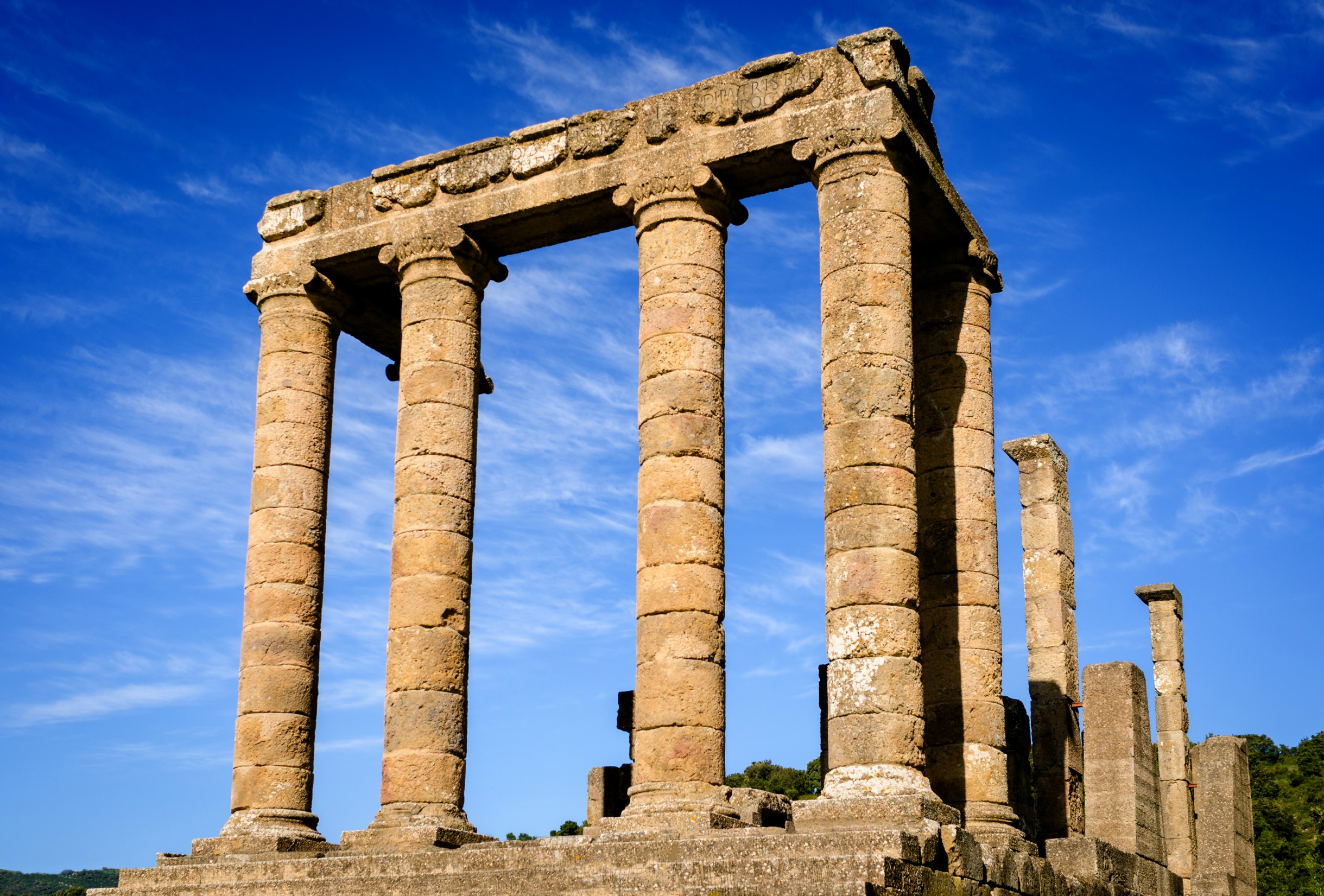
Temple of Antas
An access flight of steps and a podium adorned by elegant columns delimits the votive areas, in a context of perfect alignment. These ruins of the Temple of Antas are substantial and have reached the present day surrounded by nature, taking on the appearance of a silent Avalon in the springtime. The sanctuary was built from local limestone and is located in an evocative valley, in the Fluminimaggiore territory, dominated by Mount Conca s'Omu. In the springtime, the surrounding sacred area, which was built in a later period, is carpeted by a meadow covered in white daisies.
After having lived through the Carthaginian (around 500 BC) and Punic-Hellenistic (300 BC) periods, during which time it became very important, as is evident in the architectural elements and numerous votive offerings, the temple reached its maximum splendour during the Roman era: a first Augustan period and a second (3rd century AD) period, during which time the inscription to Emperor Caracalla was made on the pediment.
Of the steps, three levels (partially reconstructed) still remain, although there were numerous others originally; the sacrificial altar was on the fourth level, based on Roman canons. The temple is divided into pronaos with four columns - with a smooth shaft, Attican bases and Ionic capitals - on the façade and on one of the sides; an 11-metre deep cells and a floor covered with white mosaic; and an adyton with two almost-square rooms equipped with cisterns.
The temple was created (9th century BC) as a Nuragic sanctuary. Several shaft tombs bear witness to the use of the area as a burial place. In one of them, a bronze statue was recovered and portrayed a nude male divinity holding a spear with his left hand, probably the Sardus Pater or the Punic god, Sid, warrior and hunter, a representation of the local divinity Babai.

San Giovanni Cave
Its uniqueness is an inner road, entirely lit up, that runs along its sinuous length, making it a unique case in Italy and a rarity in the world. The San Giovanni grotto, commanded by Mount Acqua (540 m) on the east and by Punta San Michele (900 m) on the west, is located in the territory of Domusnovas, in the Iglesiente, three kilometres from the town. It opens at the end of a road that leads to the feet of the mountain. It is named after a chapel dedicated to the saint, which used to be protected by the grotto up to the 1800’s. It was later destroyed to make room for the road, used to transport material from the sa Duchessa mine.
Formed after the caving in of a huge calcareous mass, the grotto is divided in two levels. The fossil branch, called Bobore, is 850 metres long and is crossed by the San Giovanni river during the rainy seasons. It extends all the way to the Oridda Valley, and is characterised by wide halls peppered with stalactites, stalagmites and calcareous tubs, the greatest of which is located near the northern exit. The other branch, su Stampu de Pireddu, still active and the subject of many studies, is characterised by an itinerary 2 km long that runs among tunnels big and small, accessible only to experienced explorers.
The grotto has been used as shelter since pre-history, and has blessed scientists with many an archaeological finding, mostly bowls and containers. In its northern and southern parts, dominated by the Perd’e Cerbu range, there is a wide wall, the remains of cyclopean masonry that was still standing up until the 19th century, evidence of an ancient fortress. The rocky walls of both the northern and southern entrances, together with several crags of the Oridda Valley, lush with holm oaks and oaks, are the destination of climbers who come from all over Europe, all year round.
Along the road from the town to the southern entrance, after the former paper mill, you will see an old restored mill. After visiting the grotto, you can get to the little church of San Giovanni, rebuilt after the demolition of the chapel inside the grotto. It is located in a valley covered with centuries-old olive trees.
Proceeding southwards, you will find the sa Dom’e s’Orcu Nuraghe. Along another road that leads to the grotto, you will find numerous mining complexes: Barraxiutta, sa Duchessa, Tiny and Arenas, immersed in very dense forest.