

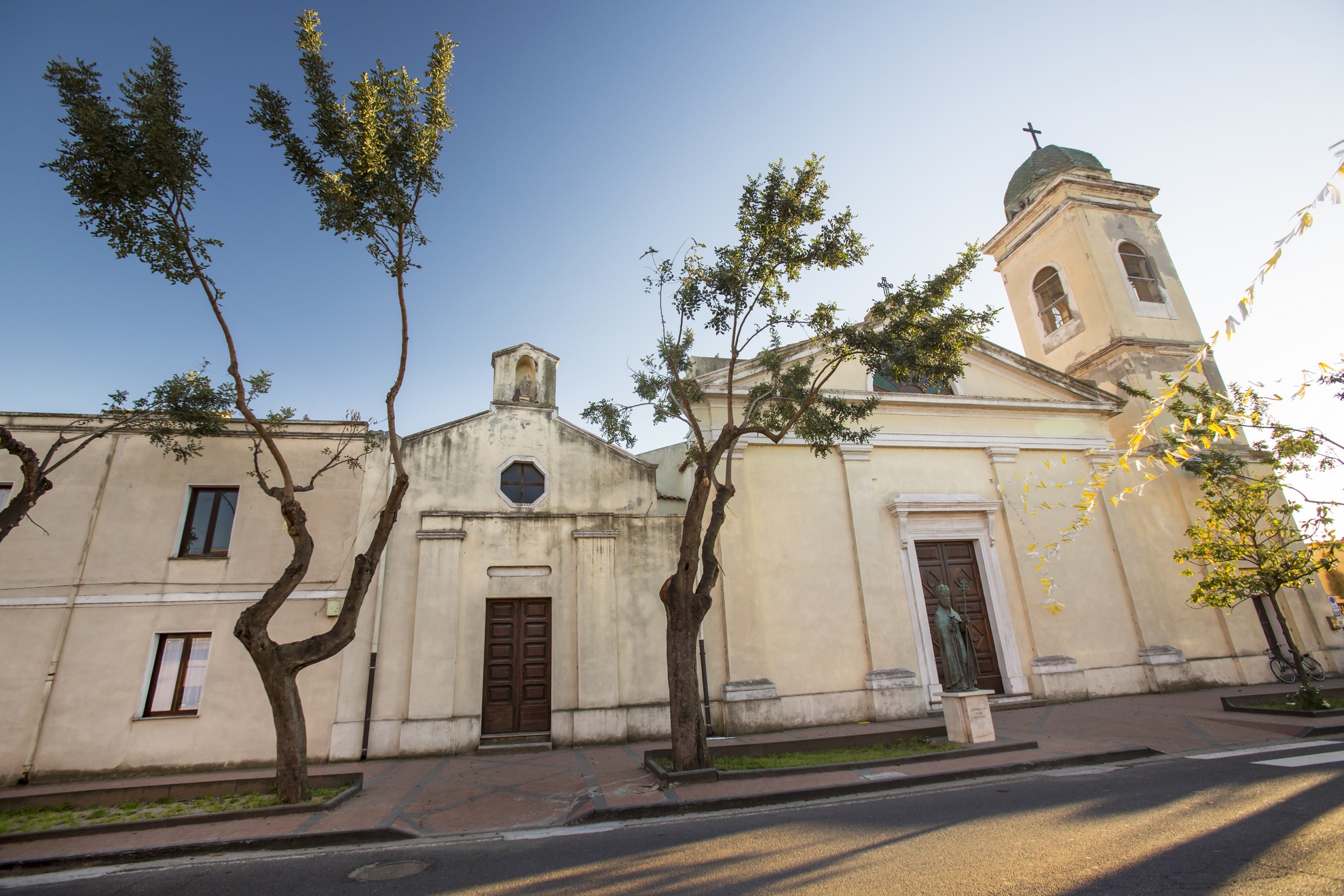
Sagama
It extends over a limestone hill overlooking the Badd’e Sagama valley dotted with colourful vegetation that contrasts with the dark basaltic stone. Sagama is an agropastoral village of 200 inhabitants in Planargia and an autonomous municipality since 1946, built within a fertile and lush area covered with woods and vineyards and peppered with springs. It is a destination for many mushroom hunters during the autumn. The town is located around the ‘treasure of Sagama’, the parish church of San Michele Arcangelo, built in 1604 based on the ‘mannerist’ model of San Giacomo di Sassari. The single-nave hall is barrel vaulted. The façade is set on three orders marked by cornices, to which a curvilinear tympanum has been added. On the left side is a three-level bell tower that is topped with a small onion dome, added at a later date. Inside the church is a precious wooden statue of the saint, 18th-century paintings, a 17th-century pulpit and wooden altars. The patron saint, to whom a small town church is also dedicated, is celebrated on 24th March and at the end of October. Also to be visited are the churches of Santa Croce, in whose piazza the Fuochi di Sant’Antonio Abate are lit, and the Vergine del Carmelo is celebrated in mid-July.
An abundance of water and rich soil have attracted settlements since prehistoric times, particularly in the Nuragic age. In the 19th century, the Sardinian historian Giovanni Spano counted a crown of nine Nuraghe structures around the town. Today, we can see the Funtanedda in the Badde Sagama valley, with a polygonal layout, the round Molineddu with single tower, near the Protonuraghe of the same name, the Pascialzos, the remains of the Nuratolu and the single-tower Muristene inside the town by the parish church, a prehistoric settlement from which the village originated. Examples of funerary architecture can also be found: the Tomb of Giants Su Crasti Covaccadu, in the locality of Terra d’Onore, and the tombs of Triganino Sa Costa-Triganinu and Fakkiganu. The era prior is depicted by an alleè couverte, on the border with Tinnura and a menhir that can be spied in Mura Pianu, known as Sa Pedra Marmurada. According to oral testimony, there were also Domus de Janas in the territory of Sagamese. From the Roman era, when the town was equipped with walls, of which you will notice the remains, are the burials in the locality of Murenda, as well as artefacts such as roof tiles, bronze fragments and coins dating back to the empire of Marcus Aurelius.
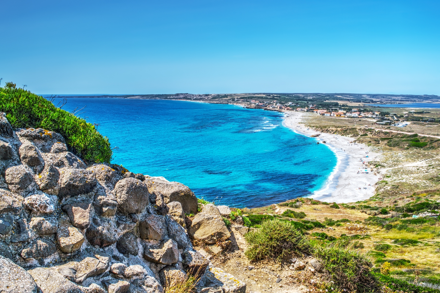
San Giovanni di Sinis
Once a fishing village, today this is a well-known seaside resort. San Giovanni, a village in Cabras to the south of the Sinis peninsula within the protected marine area, is located along the road leading to the ancient town of Tharros and, further south, the scenic Capo San Marco. The beach extends for around two kilometres, from the Phoenician-Punic (later Roman) colony to FuntanaMeiga, with a car park including space for campers. It overlooks a crystal clear sea with a seabed rich in sea life, a paradise for diving, snorkelling and underwater fishing. Constant winds also make this a destination for surfers.
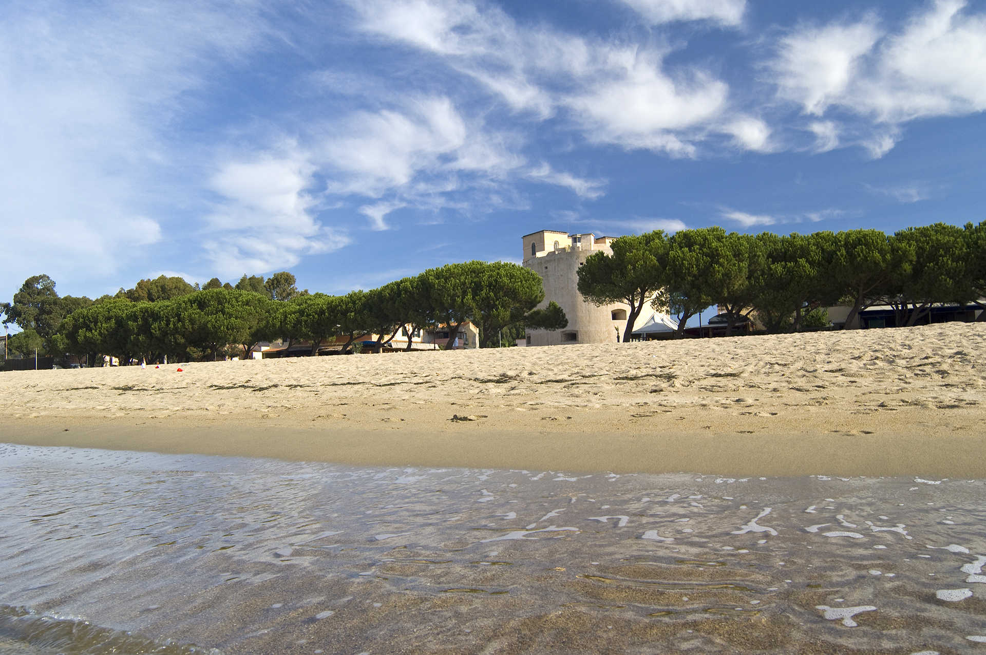
The landscape of sand dunes is interrupted by sandstone and basalt rocks as well as the suggestive Spanish tower, named for San Giovanni and built by Philip II between 1580 and 1610 to deal with pirate incursions. The tower stands 500 metres from the beach and is accessed by a slightly uphill path.
Before becoming a well-known tourist centre, San Giovanni di Sinis was a fishing village, famous for its characteristic rush huts, which were lined up along the Oristano coast right up until the second world war. Today, it is a small village with a bar, restaurants and hotels, which livens up during the summer. In the centre square you'll find a small paleo-Christian church dating back to the 5th century, originally with a Greek cross layout and later rebuilt to a Latin cross plan.
In the territory of Cabras, east of Tharros, is the beach of Mare morto, a quiet harbour for yachts, with a kilometre of rocky coast to the west. Along the 30 kilometres of protected coastline, which also includes Mal di Ventre Island, the famous beaches of super-fine quartz sand known as Is Arutas, Maimoni and Mari Ermi slope into the turquoise sea,Along the road towards Is Arutas, add a different touch to your holiday by passing through San Salvatore di Sinis, with its Wild West scenery and the location for the Corsa degli Scalzi procession. Moving on from the cliffs and sand dunes towards the centre of the island, you come across the lagunas: the Stagno di Cabras and Mistras, which are stopping points for birdwatchers. In the town, don't miss a visit to the Civico Museo Archeologico, where you can see one of the biggest archaeological finds of the late 20th century in the Mediterranean: the stone statue of the Mont'e Prama Giants, the symbol of Sardinia.

Nughedu Santa Vittoria
Perched on a ridge of volcanic rock, surrounded by Mediterranean shrubs, common and downy oaks, it overlooks a splendid panorama of Lake Omodeo, near the imposing Mount Santa Vittoria, which gave it its name along with nocetum, used in the past to describe an area rich in walnut trees. Nughedu Santa Vittoria, a small farming community of 500 inhabitants in Barigadu, on the north-eastern edge of the Province of Oristano, offers surprising natural sites: spectacular granite peaks and masses of strange shapes that stand out against the greenery, springs and rivers. The mountain is embellished by century-old holly and cork oaks of Assai forest, which is a heaven for animal life including red and fallow deer. In Alamoju, there is an Oasis of Assai Museum, housing a collection of taxidermy mammals and birds (including a golden eagle), a xylotheque, a mineral and fossil collection, and a reproduction of a forest corner.
In the centre of the oldest town in the country, a municipality since 1947, among 16th century Spanish-influenced houses, the eye is drawn to the Parish of San Giacomo (16th century) with a façade characterized by a splendid rose window and late-Mannerist gate. The cross-vaulted interior follows the Catalan Gothic tradition: the sole nave has pointed arches and barrel-vaulted chapels. Two kilometres from the town, where an ancient Benedictine Monastery (perhaps 11th century) once stood, now stands the Novenario di San Basilio Magno. The International Catalan Gothic style country church (dating to the first quarter of the 17th century), is embellished by a portico supported by columns with elegant trachyte capitals and an open gallery surrounded by fifteen muristenes, modest accommodations used by pilgrims during the novenas.
Nughedu has prehistoric origins. The necropolis of S’Angrone and of Sas Arzolas de Goi, close to town, date to the Neolithic. The latter is composed of seven Domus de Janas with a total of 18 chambers cut into the rock. Inside, you will see sculpted bull heads painted in ochre symbolizing the renewal of life. The area was also occupied more recently, as seen from the various nuraghes. The most characteristic is the protonuraghe Su Casteddu, surrounded by a grouping of sheds and a megalithic structure that is reminiscent of both dolmen and Giant’s tombs. Local cuisine also has ancient roots: visitors can try genuine, tasty dishes at festivals. The celebrations are concentrated in the summer: from the patron saint’s Feast Day in late July, to the Feast of Saint Vittoria in early August and of Saint Basilio in early September. In the summer, the town transforms into a large restaurant under the stars for the Social Eating event: the eating hall is the churchyard of the Church of San Giacomo, the cooks and servers are the town’s inhabitants directed by award-winning chefs. In autumn, visitors are received directly in the homes. Every year, Nughedu participates in the Dromos Festival of music.

Casa Aragonese
The structural elements are similar to those of the better-known ‘historic’ manor houses in Sardinia, namely the dwellings in the Campidano area with lollas, meaning ‘courtyards’. The difference consists in the fact that here, in the Aragonese House of Fordongianus, they are organised in a completely different way. The courtyard is at the back and it is not immediately accessible by going through the portal. The arcade is not ‘hidden’ by the perimeter walls: you can admire it, in front of the entrance, elegant and welcoming with its seven columns and sloping tile roof. The other big difference compared to the typical Campidano houses is the building material: like various other buildings in Fordongianus, including the Churches of San Pietro and San Lussorio, the ‘Aragonese house’ was built from red trachyte.
Its construction dates back to the late 16th and early 17th centuries. The portico, however, was rebuilt in recent times with the anastylosis technique, reusing the original parts. The building extends lengthwise, with a series of thirteen adjacent and communicating rooms. As a matter of fact, there are two houses: Casa Sanna and Casa Madeddu, named after the last owners. The ‘front’ part, including the portico and seven rooms - three at the front and four at the back - corresponds to Casa Sanna. A corner door connects the two houses and will lead you into the spaces of Casa Madeddu, with four rooms on the ground floor and two mezzanine rooms above the front bedrooms. The house was ‘divided’ at the end of the 19th century, by walling up the corner door.
You will notice Gothic-Aragonese elements in the decorations of the furnishings both in the arcade and inside. There is a moulded arch over the entrance door, with small columns with carved capitals on the sides. The distinctive inflected arch is beautifully displayed in the small internal portals, while the frames of the niches and windows feature raised diamond tips and diamond shapes. Built-in wardrobes and seats against the windows appear in the rooms. In the courtyard, which is also accessible from a secondary entrance, you’ll find the vegetable garden and garden, the stable and an area intended for parking agricultural carts.
Today the ‘house’ is used as an exhibition space: a series of wire mesh works stands out, depicting female figures engaged in domestic work. Temporary exhibitions are periodically held here. After the visit is over, you can go to discover the other jewels in the territory of the ancient Forum Traiani: a visit to the thermal baths, probably known since prehistoric times and enhanced in Roman times, is a must. The architectural heritage includes the sixteenth-century parish church of San Pietro Apostolo and, one kilometre from the town, a medieval church dedicated to Saint Luxorius, where you can also admire the crypt with the tomb presumed to be of the martyr and the cumbessias where the pilgrims stayed.
Torregrande
Three kilometres of golden sand, running from the marina to the mouth of the River Tirso, bordered by tall palm trees and a beautiful esplanade, this is an ideal seaside area for holidays full of swimming and diving, jogging and sport, on horseback, by bicycle or in-line skates, with evenings of music and fun. Torregrande is the beach of Oristano, 10 kilometres away, and is named for the main square of the small tourist town founded by farmers and fishermen. Here you'll find the Spanish tower of the same name, the largest in Sardinia, built between 1542 and 1572. This is a lively area full of bars and clubs, concerts and shows, restaurants and festivals, exhibitions and markets.
If you're a horse lover, the nearby riding schools offer horseriding on the beach, stupendous at sunset, while the clear sea rich in marine flora and fauna make for diving like in a documentary. The beach has received the Legambiente Blue Flag several times, and hosts the coastal marine environment institution of the Italian National Research Council (CNR).
The long stretch of sand has all mod cons: disabled access, ample car parking, suitable for campervans, kiosques and beach equipment, children's play areas, sailing and diving schools. Along the beach you can play beach volley or beach tennis, hire pedal-boats, boats and windsurfing equipment. The sea is nearly always calm, although the seabed quickly gets deep: it's family friendly, but keep an eye on small children. The modern Torregrande marina is Oristano's tourist port, in the centre of the gulf, the starting point for trips from the picturesque Capo San Maro to the Sinis marine area, passing some magnificent beaches on the way: San Giovanni, Maimoni, Is Arutas and Mari Ermi (in the territory of Cabras) and Putzu Idu (in the territory of San Vero Milis).
The tower is the largest one left in Sardinia by the Spanish occupation, although the centre of Oristano also has several traces of fortifications, first from the middle ages and then from the Aragon period, in particular the tower of Mariano (or San Cristoforo) in Piazza Roma, the most important remains of the town wall that surrounded the d'Arborea jurisdiction. Dating back to 1290 and 28 metres high, it was built in sandstone blocks from Tharros by master stonemasons from Pisa, commissioned by Judge Mariano II, then "retouched" by the Aragon family.

San Nicolò d'Arcidano
It lies in a flat stretch crossed by Flumini Mannu and Rio Sitzerri and enclosed by the ranges of Monte Linas and Monte Arci, a short distance from the Arborea marina and less than half an hour from the magnificent and wild beaches of the Costa Verde (Arbus). San Nicolò d’Arcidano is a town with 2,000 inhabitants, bordering the province of Oristano in southern Sardinia, whose main resources are agriculture and craftsmanship, well-represented by the Arcidano Produce event held in mid-August, exhibiting and selling agricultural and artisan products. Its viticulture is particularly renowned, thanks to the Bovale and Su Muristellu vines, from which derive esteemed wines. Inside the village is Sa Mizza de Fagoi, an ancient spring that once quenched the thirsts of shepherds and travellers.
At the highest point, along with the town’s centre, stands the parish church of San Nicolò Vescovo, the origins of which are uncertain. The last reconstruction is likely to have been around 1660, certainly before 1763, when a neoclassical façade was erected with a Greek temple front made of columns that support a triangular tympanum. The patron saint from whom the name of the town derives is celebrated in September, upon the ‘opening’ of the harvest season. Other religious festivals are held at the end of June for Sant’Isidoro, protector of the farmers, and at the end of July for Santa Margherita. Its peak, today occupied by the parish church, once held the Nuragh’e Luxia, one of the seven Nuragic structures of the Arcidanese territory. Most of them are ruins, the most important being the Peppi Tzappus, a polylobate, near to which is the Nuracciolu. Both are in the locality of Is Codinas, where traces (in the form of brick walls) of the Roman era are also evident. There were probably once villas, whilst funeral urns were found in San Pantaleo and Santa Barbara. Also from the Roman era is the stone holding the cross positioned on the road at the exit of the village, heading towards Uras. Remnants from Roman times are manifest thanks to the proximity to the ancient city of Neapolis, where a significant trade port existed since the Phoenician-Punic age. Commencing in the 15th century, it became a landing point for the raids of barbarian pirates who looted the territory and forced the abandonment of many towns, including the Architano, meaning ‘on the road of the Arci’, being that which led to where precious obsidian was extracted and sold in prehistoric times it. Under the Giudicato of Arborea, there were two villages: Architano Magno, with a church dedicated to San Nicolò, and Architano Parvo, abandoned in the second half of the 14th century. The name Arcidano was restored in the mid-17th century, when a nucleus of about 60 families from Samassi and Furtei re-established the town. The first documents attesting such date back to 1665.
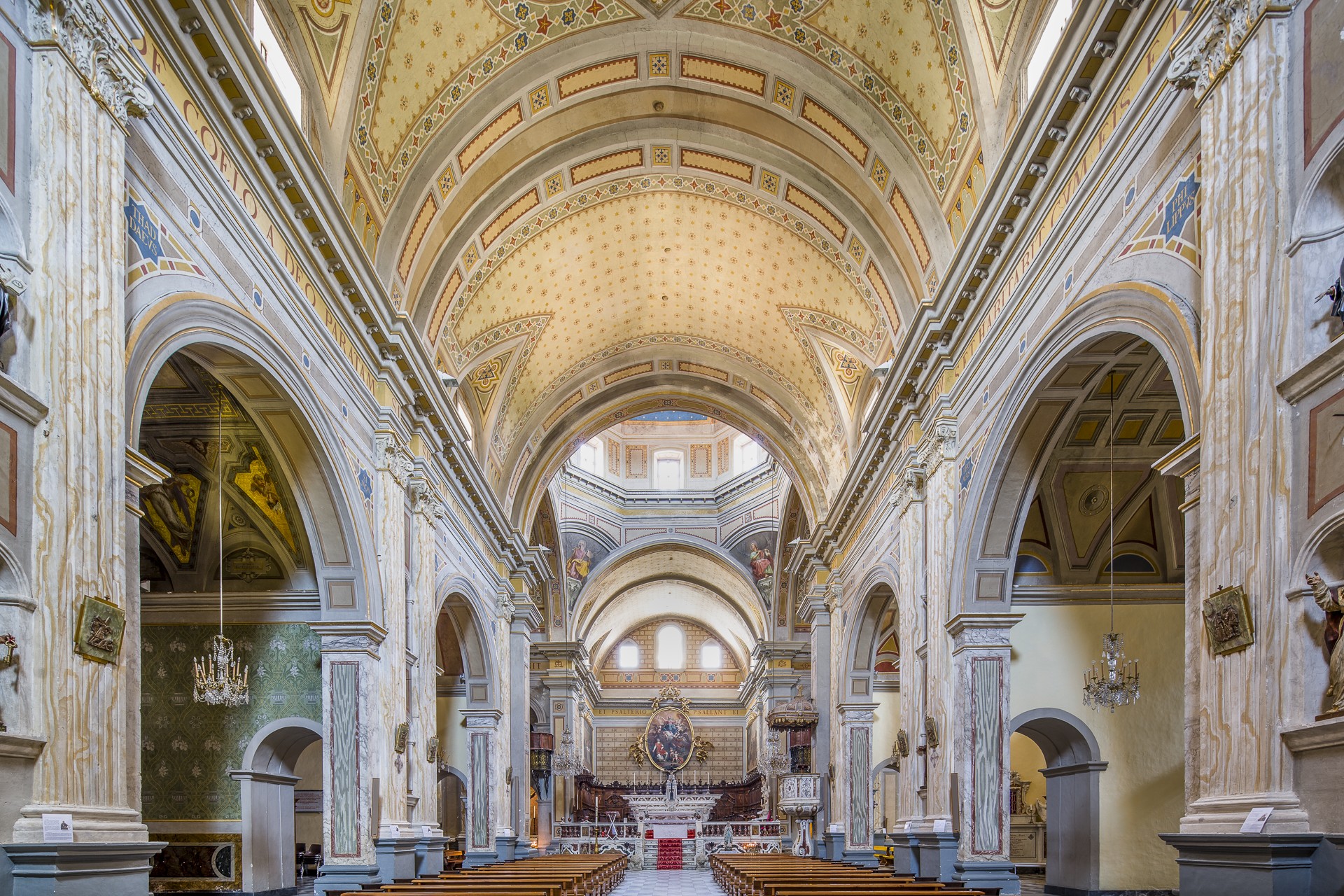
Santa Maria Assunta - Duomo di Oristano
The Santa Maria Assunta cathedral was elevated by Pius XII to the rank of minor basilica. The ‘mother’ church of the Arborea archdiocese, the Duomo di Oristano was built on a Paleo-Byzantine structure and atop 6th-7th century Byzantine tombs situated in the parvis of the church. According to tradition, the capital of the Giudicato di Arborea was transferred from Tharros to Oristano in 1070. Documentation from 1131 lists the Ecclesia Sanctae Mariae de Orestano as already being a cathedral. The 16 marble casks housed in the Tridentine Seminary, which overlooks the courtyard of the cathedral in front of the Chiesa della Santissima Trinità (18th-19th century), suggest that the original Romanesque structure of Santa Maria (11th-12th century) had three aisles, with perhaps eight columns on each side dividing the space within. In the first three decades of the 13th century, the church was ‘overhauled’ and in the mid-14th century, the transept was added with four chapels in Gothic-Italian style, including that of the Madonna del Rimedio, today amongst the very few original elements to survive.
The works also spared the archives, built in 1626 as a presbytery chapel, a project in which the late Gothic tradition and Renaissance classicism coexist harmoniously. Two ‘neoclassical chapeaux’ dating back to the 19th century in the extremity of the transept are those of San Luigi Gonzaga and San Giovanni Nepomuceno, adorned with sculptures by Andrea Galassi. The interior is heterogeneous - elegant baroque patterns alternate with neoclassical forms, through to contemporary styles. From a single wide barrel-vaulted nave, open up three chapels on each side. The apse is rectangular. The presbytery is elevated and enclosed by a marble balustrade with two lions at the base of the access staircase. Countless works of art enrich the temple - the wooden statue of the Annunciation and the marble statue of the Madonna del Rimedio (14th century), the baroque altar and the polychrome wooden altarpiece (18th century), a round canvas depicting the Assumption and two rectangular works by Marghinotti (Adoration of the Magi and The Last Supper). The cathedral’s treasures also include silverware, sacred vestments and illuminated choir books. The exterior is a superimposition of styles. On the left side stands the octagonal bell tower, topped with a small ‘onion’ dome, decorated in majolica.
Setting out from the cathedral, the historical centre can be visited, where the famous Sartiglia is staged during Carnevale. Protagonist of Sardinian events since the 11th century, Oristano was protected by walls and fortifications, such as the majestic Torre di Mariano. Prestigious buildings like the Palazzo Corrias Carta, the archiepiscopal palace and the neoclassical church of San Francesco and the gothic one of Santa Chiara are also to be admired. Not to be missed is the monument of the Giudicessa Eleonora and the Arboreal Antiquarium.
GeoMuseo MonteArci
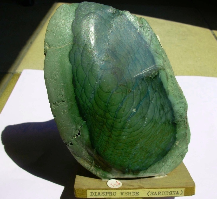
On display are thousands of minerals and fossils on which the geological evolution of the island and specifically of Marmilla is written, with a complex history spanning from around 20 million to about two million years ago. Set up in the premises of the former convent of the Capuchin Fathers, a monumental monastery from the mid-17th century - to which is attached the church of San Francesco - the Geomuseum of Monte Arci in Masullas is a one-of-a-kind in Sardinia, arising from the patient work of Vincenzo Incani in collecting and cataloguing, resulting in the mineralogical and paleontological collections. To be admired are specimens of stones with fossils of ancient marine animals, dioramas that reflect the volcanic activities and various minerals, in particular colourful jasper (rocks from the marine environment), formed during the eruptions of the 'old volcano' of Monte Arci. In the ‘sala flù’, you will be dazzled by spectacular minerals with fluorescent colours.
At the beginning of the museum itinerary, there is a brief excursus on the formation of the lands that emerged in the world resulting in the formation of the Mediterranean and Sardinia, before then moving on to the evolution of Monte Arci, originally a very active volcano that was a hub for the collection and processing of obsidian in prehistoric times and is now a gentle relief covered with greenery, which has become a regional park. Originally, the Mediterranean was the small continent of Alkapeca, which as of 23 million years ago fragmented into four small clumps: in the Sardinian tectonic plate began to form fractures, which caused a long and deep depression (rifting), from the Golfo di Cagliari to the Gulf of Asinara. The sea transformed the island into an archipelago. Through the fractures, huge quantities of basaltic magma erupted on the base. In the area of today’s Arci, an enormous submarine volcano was formed, extending over 30 kilometres. The eruptions gave rise to pillow-lava, which you can see in su Carongiu de Fanari, on the outskirts of Masullas. In addition to fossils of fish and jaspers, the museum also contains minerals of hydrothermal origin, such as quartz, chalcedony, fluorite and calcite in large crystals.
After some stagnation, eruptive activity resumed violently 5 million years ago, with the ancient reliefs covered with imposing layers of lava of various materials. The precious obsidian coming from the flows of rhyolites rendered Monte Arci the centre of the Mediterranean as early as the 6th millennium B.C. The obsidian park of Conca ‘e Cannas and the obsidian museum of nearby Pau, to be visited in combination with the Geomuseum, are dedicated to the ‘black gold of prehistory’. Before the volcano finally died out, 1 million and 800 thousand years ago, basaltic flows poured into forming the large tablelands of the Giare plateaus, typical of the current landscape of Marmilla, and in particular of Masullas, which is part of the Borghi Autentici d’Italia (Authentic Villages of Italy) thanks to urban architecture, beautiful landscapes, archaeology, traditions and delicacies.

Natural Oasis of Assai
A green lung made up of woods filled with holm and cork oak trees, interspersed with granite pinnacles, an area that once supplied coal to all of Sardinia and today preserves and protects indigenous vegetation and wildlife, as well as being home to an interesting museum. The Assai oasis extends for almost a thousand hectares between the territories of Neoneli and Nughedu Santa Vittoria. An ancient coal pit bears witness to the activity that thrived here, alongside the production of cork, until the 20th century. In 1983 the state forestry department took it over and Assai is now a permanent wildlife preservation zone. Today Sardinian deer, wild boar, fallow deer, wild cats and martens have made it their habitat. Among the birds, you may well spot some endemic Sardinian-Corsican species such as the sparrowhawk and the great spotted woodpecker, as well as rock thrush, raven and Sardinian partridge. For a few years now, even the golden eagle has returned to nest at the oasis.
You can also visit the wildlife museum housed in an ancient shelter once used by shepherds deep in the heart of the naturalistic reserve. The exhibition features stuffed specimens of the local fauna – mammals, birds and birds of prey – among which a golden eagle stands out set in a diorama that represents the forest. There is also a collection of minerals and fossils from all over the island. Outside, besides the coal pit, you can also visit a characteristic pinnettu.
The vegetation here is also extraordinary: you will admire species typical of the Mediterranean brush, such as arbutus, ivy and lentisk, as well as flowers, in particular cyclamen, hawthorn, Spanish broom, lavender and wild orchids. The woods have paths you can follow either on foot, mountain bike or on horseback, with numerous panoramic points along the way to enjoy. One of the trails goes by the vista point of Borta Melone, at almost 900 meters above sea level, then by an artificial lake, finally leading to the natural monument of sa Crabarissa, a 50-metre-high granite rock whose shape resembles that of a woman in traditional Sardinian dress. An aura of legend surrounds her: the Crabarissa – meaning a woman from Cabras – was a girl engaged to a shepherd from Austis. When the shepherd left the town of Sinis to return to his own village, she stayed behind to wait for his return. When she became aware that days had gone by since she had heard from him, she went to Austis only to discover that he had married another. On her return home, the searing pain turned her to stone.
Simaxis
It lies along the left bank of the Sant’Elena River, a tributary of the Tirso, on a segment of fertile plain long farmed for wheat and more recently for rice. Simaxis is a town of 2300 inhabitants in northern Campidano. It dates to the Medieval Period: it was the largest town of a homonymous curatoria in the Giudicato of Arborea. The original village was destroyed during the French invasion of 1637 and resettled in mid-19th century when lands that have grown marshy were drained and farming began in full once more. As testimony of its prosperity, the Day of Rice is held every November. Another agricultural symbol is the 19th century grain bank. The retro-style Carnival of Sa Coja de Tziu Damus is original. It foresees a marriage performed by an actor impersonating the mayor and the participation of townsfolk in traditional dress.
The proximity of Monte Arci Park, containing the island’s only obsidian deposit, the Prehistoric ‘black gold’ of the Mediterranean, and the fertility of the lands, supplied by numerous water sources, have always attracted settlers. Traces of two Neolithic villages (Ozieri culture) were found near the river, with findings that include representations of the Mother Goddess. The area was also densely populated in Nuragic, Phoenician/Punic and Roman eras. The Byzantine period is represented by three churches named after cults and saints from the Eastern Christian world. Two kilometres from the town, in the hamlet of San Vero Congius – a village known since 1140 as Sant’Eru of Simagis and an independent municipality until early 20th century – rise the ruins of the churches of San Nicolò di Mira and of Angelo (with a hemispherical dome), and of the ancient Parish of San Teodoro of Amasea, a military saint of the Byzantine tradition. Dated to between the 7th and 9th centuries, it has a cruciform plan with a barrel vaulted transect and a crossing topped by a dome. The church has been restored several times. In the centre of the town, the eye is drawn to the Parish of San Simmaco Papa (Pope Symmachus), consecrated in 1833. The pope is thought to have been born in Simaxis, although this assumption is based solely on the similarity between the names of the Pope and the town. The Liber Pontificalis, the only historical document to mention Symmachus, list only his pontificate period (498-514). However, in the Epistle, the saint confirms his Sardinian roots himself: he was the second Sardinian Pope after Saint Hilarius. The church was built over the site where his home was thought to have stood. The Neoclassical-inspired façade is topped with a tympanum containing a stained-glass window with a fragmented pattern. The interior consists of a single nave with three chapels per side. Saint Symmachus is celebrated in late January and mid-July, the saint’s birth and death days, respectively.