

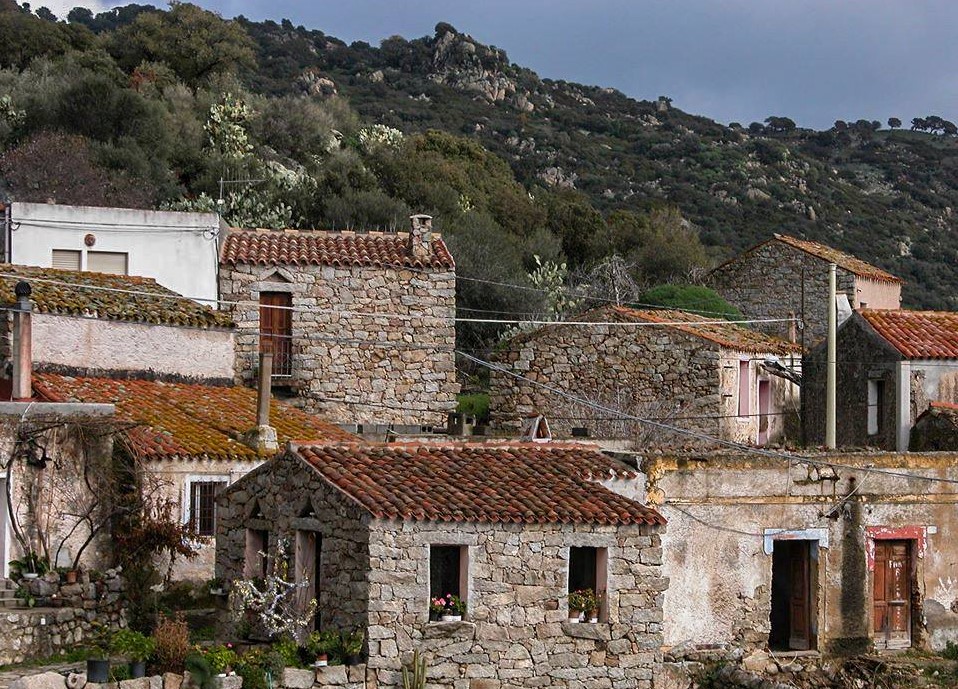
Benetutti
A town of some two thousand inhabitants in the Province of Sassari on the slopes of the Goceano high plains. The Benetutti area has magnificent views over the upper valley of the Tirso river and includes ancient forests that are home to deer and foxes, a haven for hikers and mountain bikers. Thermal springs and archaeological remains are the main attractions of a town steeped in the traditions of agriculture and craftsmanship, in winemaking, baking and the preparation of sweets enjoyed during local festivities. Weaving, working with iron and stone provide a touch of modern artistic flair.
It’s an ancient town whose outskirts are home to traces of settlements that date back to the Neolithic Age: the statue menhir of monte Mannu, dolmen (stone tombs) of monte Maone (III millennium BCE) and the domus de Janas at Luzzanas and Mandra e’ Giosso, the only one of its kind in Sardinia with two storeys. There are also remains from the Nuragic Age, like the Giant Tombs, the s’Aspru nuraghe, the largest in this area, and the Sisine, Puddighinu and Carvoneddu. And, finally, the Roman ruins: a thermal bath with marble steps on the premises of what is now the San Saturnia thermal springs establishment.
The many religious festivities and churches bear witness to the deep devotion that marks life in the town. Among the more important churches is that of sant’Elena Imperatrice, built between 1400 and 1618. The 25m high domed bell tower was added in 1670. Inside the church is a retable from 1549, a highly original expression of Sardinian Renaissance art, and a valuable wooden statue of St. Michael. The patron saint is celebrated in mid-August with the gosos, limba liturgical chant and a gathering of folk groups from all over the world. Another much beloved religious celebration is that of sa Chida Santa, Holy Week. The town and its outskirts are dotted with a myriad of churches: the churches of Santa Croce (early 1600s), San Timoteo, Santa Rosalia, San Salvatore, the Beata Vergine di Boloe, Santa Barbara and the ancient temple of San Saturnino, which dates to the XI century, built over a previous Nuragic structure. Next to the country church are the famous springs and thermal baths, famous since ancient times. The Romans built baths here and called them the Aquae Lesitanae, and their therapeutic qualities remain sought after. Ptolemy, the celebrated astronomer, mathematician, geographer and physicist, wrote about them in the 2nd century CE, and still today the San Saturnio baths ensure that Benetutti remains a centre for thermal treatment.

The Gennargentu Massif
Silver spray in the wintertime, deep green or reddish streaks in the other seasons. These are the colours of the Gennargentu massif, the Sardinian mountain par excellence. As you will be able to see from the map, or better still in person, this is a complex mountainous area including various offshoots, one of which is Supramonte, extending northwards almost as far as Nuoro, and to the south as far as the valley of Flumendosa, while from east to west they go from the Tyrrhenian sea to the Tirso river. This is where the main waterways originate and run down to the eastern coast of Sardinia.
If you are well trained and carrying the right equipment, albeit with some breathlessness and with constantly taut muscles, you can reach the highest peaks in Sardinia: Bruncu Spina and Punta La Marmora, around 1830 metres high. Here, you can relax and enjoy a 360-degree view of a largely unspoilt, wild territory, carved out of canyons and deep gorges, with its most ancient gullies and coves made of granite and schist. Looking up to the sky, you will often see the golden eagle, red kite or a griffon vulture circling, while in the clearings you might easily come across wild boars, foxes and martens.
The botanic repertoire is also precious and typical, including centuries-old downy oaks, holm oaks, taxus trees, chestnut trees, common hazels, dwarf junipers, thymus and helichrysum plants.The entire area is full of environmental microsystems,each to be visited one by one: the protected areas in the valleys and mountains of Uazzo (in the territory of Tonara and Belvì) and FuntanaCungiada (in Aritzo). The southwestern side of Gennargentu is dotted with interesting archaeological ruins, like the Nuraghe Ura 'e sola located high up at an altitude of 1330 metres, and with beautiful views, like that along the valley of Rio Aratu.
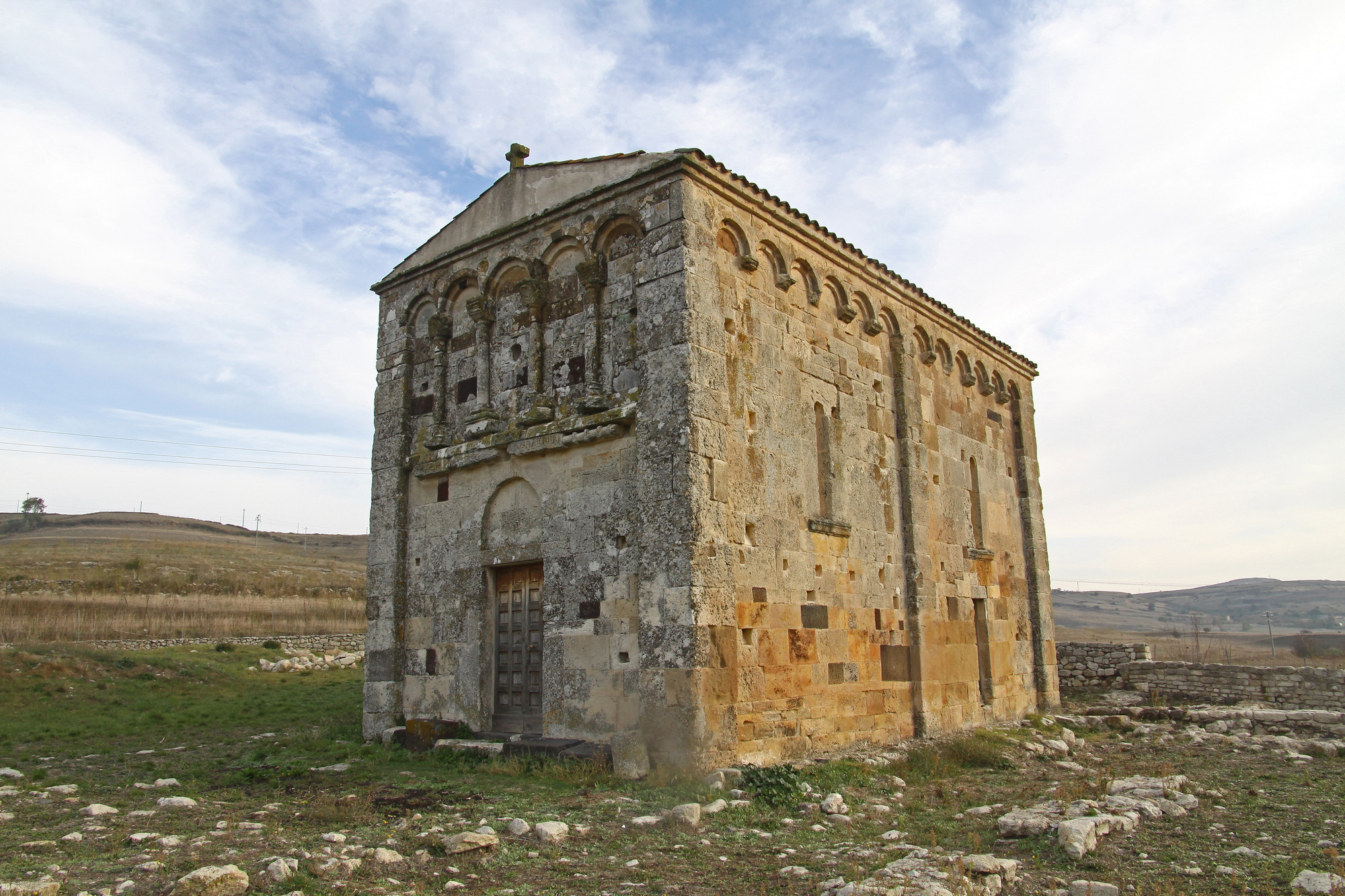
Church of San Nicola di Trullas
It is situated two and a half kilometres from the residential area, in the open countryside, on the Campeda plateau, in a portion of the vast and fertile territory of Semestene, which has revealed important archaeological evidence. The church of San Nicola di Trullas (or Truddas) stands on the ruins of an ancient site: it was originally a villa dating back to the Roman period, on which a Camaldolese monastery was established, along with a surrounding village, during the Middle Ages. It was built at the behest of the Athen family (prior to 1113) and donated to the Camaldolese monks, who added it to the monastery. The first information on it is in the condaghe of San Nicola di Trullas (12th-13th centuries).
It is one of the most interesting Romanesque buildings in Sardinia. Along with the elegance of its architectural forms, you can admire the precious frescoes that decorate its interior and that date back to the 13th century. The façade is separated into two parts by a horizontal frame: in the lower part there is the architrave portal, while in the upper part there is a series of little arches on columns, creating a false loggia. Every little column has a suspended capital on top of it, decorated by incisions or reliefs. Between one arch and the next, you will see ashlars with housings for ceramic basins. Other little arches also run along the end of the sides and the apse, which are accompanied by a central lesene. On the sides, the light penetrates through two single-light windows. Inside, the room with a single nave has two square bays that have cross-vaults and are separated by a transverse arch set on lesenes.
At the beginning of August, the festivity of Saint Nicholas takes place: a procession reaches the little rural church in order to take the statue of the saint to the village. A week later, the religious and civil celebrations begin. Once they are over, the reverse journey takes place, to return the simulacrum to the sanctuary. Among the churches, there is also the parish church of San Giorgio which deserves a visit. It dates back to the 12th century and is located in a scenic position. The medieval village of Semestene occupies a fertile valley crossed by several torrents, at the foot of the volcanic Mount Benazzosu, surrounded by other slopes. This is a territory in which there are numerous Nuraghi and you will see evidence of the Roman era: it appears that, where the village now stands, there was originally one of the seven districts of the big Roman town of Truddas.
Sarule
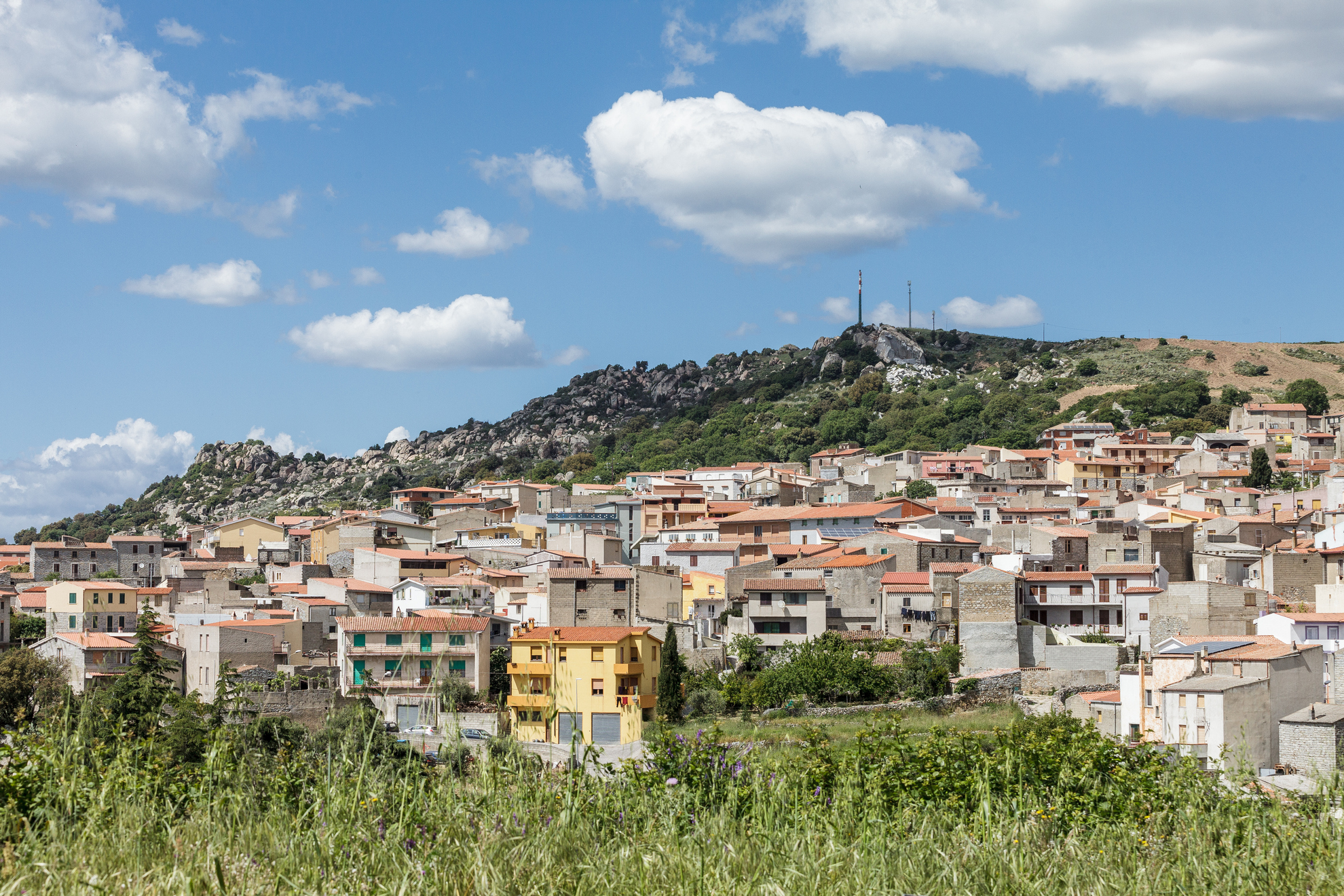
On the top of the mountain behind it, at an altitude of 1,100 metres, is Sardinia’s ‘highest’ church, Nostra Signora di Gonare. Sarule is famous for its famous Marian sanctuary and sits at an altitude of 600 metres in the heart of the Barbagia di Ollolai. It is home to 1,700 inhabitants. Surrounding town are three calcareous peaks encircled by grey granite: Gonare, Gonareddu and Punta Lotzori. On a clear day you can see the sea both to the west and the east. The town is a farming and shepherding town, they make fine cheese that is famous and exported, just like their olive oil, made from olives that grow on trees hundreds of years old that dot the landscape.
The town is renowned for its carpets. They are colourful – yellow, black, red, and brown - and stylized with geometric designs or graced with figures from the farming tradition or nature. The carpets are woven on standing looms and Sarule is especially famous for its unique burra, a rug made using a centuries-old technique handed down over generations. You’ll see examples of them in the shops in town and at the museo della tessitura Eugenio Tavolara (textile museum). You can also see examples of a burra at the museo etnografico in Nuoro.
The area around the town has been lived in since the Nuragic Era, as proven by a variety of nuraghes at Incavadu, Valeri, Neunele and Durghio. In the Late Middle Ages the town was under the control of Ospitone, an emissary sent by Pope Gregory Magno to convert the local population. Christian belief took hold and set deep roots: the church of Nostra Signora di Gonare is one of the island’s most popular pilgrimage destinations and dates to the early XVII century, although its origins remain obscured by legend. One part of the sanctuary wall and the cumbessias (accommodations for the faithful) belongs to the parish of Orani, and, in fact, the heartfelt festivities that take place early September alternate between Sarule and Orani. Celebrations begin with a novenario and gosos (devotional chanting) and feature a via crucis up the slope, followed by an equestrian joust. The Virgin is celebrated another two times during the year: on 25 March for the Annunciation, and on the last Sunday of May, coronation. The faith of the locals is felt with great passion during Holy Week rituals as well, especially during the s’Incontru ritual on Easter Sunday. Pagan influences resound during local carnival festivities and in the gattu (cat) masks donned by the locals, mentioned in the book Elias Portoblu written by the Sardinian Nobel author Grazia Deledda.

Monte Gonare
According to legend, the judge of Torres Gonario II (1110-82), after returning from a crusade to the Holy Land, was surprised by a storm and turned to the Virgin Mary, promising to build a church in her honour on the first strip of land he saw, if he survived. A peak, filled with light, was his salvation and it was here that he built the sanctuary. In reality, the little church of Nostra Signora di Gonare, now a destination for pilgrims from all over the Island, was built later on, around the beginning of the 17th century.
The name of the mountain came from Gonario, halfway between the territories of Orani and Sarule and exceeding a thousand metres, consisting of three cone-shaped peaks: Gonareddu, Punta Lotzori and Gonare, where the most captivating Marian sanctuary in Sardinia stands. Here, where you can breathe in the healthy air, the landscape stretches from the gulf of Orosei to that of Oristano.
The massif has steep limestone walls that slope down to the valley and are covered in chestnut, holm oak and downy oak forests, while smearwort, helichrysum, ferns, orchids, peonies and mountain roses colour the landscape. Rare species of bat and the tree frog live in amid the foliage.
Monte Gonare was celebrated in prose by Grazia Deledda, in poetry by Sebastiano Satta and in paintings by the artists Antonio Ballero and Mario Delitala. Various events bring the mountain to life: on 25 March, on the occasion of the Annunciation, pane 'e vintichimbe is provided to the pilgrims. The coronation is celebrated at the end of May and on 8 September the Festa Grande takes place, handled by the inhabitants of Orano during even years and by those of Saru during odd years. Preparations begin at the end of August: the inhabitants of the two villages go to the sanctuary to participate in the novena. The pilgrims reside in the cumbessias, lodgings situated around and downstream of the sanctuary. The residents reach it on foot every day along ancient trails. From the centre of the villages, they walk uphill along Sos Malavidos and Illudine to the 973 metres of the Sa Corte square. From here, a path dug out of the rock, which is steep and marked by various places of worship, leads to the church.

Sorgono
DH Lawrence was so enchanted by the town that he dedicated a chapter to it in his book "Sea and Sardinia" (1924): Sorgono is located right in the centre of the island, 700 metres above sea level on the western side of the Gennargentu, surrounded by woodlands of conifers, holm and downy oaks, chestnuts, hazelnuts and Mediterranean scrub, populated by mouflons, roe and fallow deer (in the santu Loisu nature reserve) and home to royal eagles and peregrine falcons. The town has a population of 1700 and is the hub of the Mandrolisai area, to the far south-west of the Barbagia region, a land of strongly rooted traditions and linguistic blends, where the local dialect is "di mezzo" Sardinian. The territory is marked by granite mountains sculpted by the wind and suggestive panoramas overlooking the Iscalas plateau, towards Serra Longa and the forests of Mount Littu and Uatzo, crisscrossed by trekking paths and the Trenino verde railway that starts in the town.
Around 50 natural springs in the areas rocky terrain give "healthy" spring water, in particular those of Perda ‘e Mantza and Erriu de Sauccu. The mountains alternate with soft hillsides used to grow cereals and cannonau, monica and bovale vines, used to make mandrolisai wine. At the end of October the famous wine is the protagonist, along with traditional dishes such as lampazzu soup, of the sa Innenna festival.
The town was first documented in 1180. It was a ‘signoria utile’ during the Aragonese occupation, which left traces in the architecture in the old town, made of stone-built homes in intricate alleyways. The 17th century Casa Carta and the Serra house-museum with their antique furnishings are particularly worthy of note. The art of engraving and carving is on display at the wood museum. The exhibition is set up in a building with a garden, at the centre of which stands the 17th century Funtana Lei artistic fountain. The parish church of Santa Maria Assunta is also in late Gothic style, built in the 16th cenutry and subsequently modified. The other religious buildings are outside the town: Nostra Signora d’Itria, around a kilometre away in sa Pala ‘e Cresia, San Giacomo, originally the church of the abandoned village of Spasulé, and the Santuario di San Mauro, formed of a late Gothic church and muristenes inhabited by pilgrims during the festival at the end of May, surrounded by ancient woodland on the slopes of Mount Lisai. This is one of Sardinia's religious symbols. The church dates back to 1574 and is 30 metres long and 9 wide: the grey trachyte facade features a Gothic rosette which is by far the largest on the island. Outside you will notice the tower of the Giants' tombs of Funtana Morta, a burial linked to the Talei protonuraghic era, located a few hundred metres away. The Bronze Age also left another twenty-odd nuraghes, including Orrubiu, Calamaera and Lò, along with another ten Giants' tombs and the village of Ruinacchesos. The most important archaeological attraction is the archaeological park of Biru ‘e Concas, which hosts one of the most extraordinary concentrations of standing stones in the Mediterranean, with around 200 proto-anthropomorphic, anthropomorphic and statue menhirs dating back to 3200 to 1800 BC, surrounded by a wall that may have served to close off the holy area. Wherever you walk in the park you will come across monumental stones, on their own or in pairs, triads, circles or lines. The domus de Janas at Perdonigheddu and Santu Loisu date from the same period.
Le vie dell'acqua - Tiana
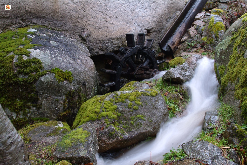
Between the 18th and mid-20th centuries, the Tiana landscape beside the waterways was dotted with mills and fulling mills, on which the town’s economy was based. Today, the only piece of evidence of all this is even more important because it is the last fulling mill active on the Island and one of very few still remaining in Europe. Along the Rio Torrei, there is a complex made up of a mill and two fulling mills - one of them, the active one, is known as sa Cracchera de Tziu Bellu – and, together, they make up the industrial archaeology museum of ‘Le vie dell'acqua’ (water routes). The water mill was used for grinding wheat, which was widely grown in the area, while the fulling mills were used for fulling the wool, i.e. beating it to obtain felting. Tiana was particularly specialised in the processing of orbace, a fabric obtained through a particular process of spinning sheep’s wool, widely used in the past to make traditional clothes.
The fulling mill is a stone building, with a wooden roof, inside which you can see the downy oak mallets. They are operated thanks to a mechanism connected to the water wheel, which is in turn activated by the flow of the adjacent torrent. The mallets strike a bumper, on which the orbace fabrics are placed - which are continuously wet with hot water - thereby becoming softer, more resistant and waterproof. The final step is dyeing, which traditionally took place using natural products: saffron, pomegranate, walnut, chestnut and grapevine.
Thanks to the fulling mills, until the mid-20th century Tiana was a point of reference for numerous Barbagia towns, whose inhabitants often bartered the service, offered by giving meat, cheese, nougat and wine in exchange, thus obtaining the necessary fabric for their typical attire. The periods of operation were mainly autumn and winter, for two reasons: during the cold seasons the flow of the river was greater and, in addition, sheep shearing took place in early summer, after which it was necessary to wash and weave the raw wool.
Sa Cracchera de Tziu Bellu ceased its activity in 1975, but it returned to operation during visits and on the occasion of events such as the stage of Autumn in Barbagia. It is an opportunity to explore the town’s surroundings, largely covered in woods, taste the typical local products, visit the churches - in particular the late Gothic parish church dedicated to Sant’Elena - and admire the archaeological heritage. The necropolis of Mancosu stands out, dating back to the Neolithic period, with its domus de Janas, that are called forreddos here, based on their shape, which resembles bread-baking ovens.
Meana Sardo
The town spreads out in a panoramic position in the foothills of Mount Sant’Elia, on the south-western edges of the Gennargentu massif. Meana Sardo is a town with a population of less than 2000 in the Barbagia di Belvì area, which is documented as far back as the 12th century. Its convivial, welcoming spirit comes out every year at the beginning of October in the Domos Antigas, an event that is part of the Autunno in Barbagia circuit. The whole town is involved: the cortes courtyards are opened along with the cellars of the ancient stone houses, decorated in Aragonese style, with local agricultural and craft products on display. Don't miss the cheese festival at the end of June (during the celebrations for San Giovanni), where you can taste pecorino and other traditional cheeses. In the centre, at the top of a flight of stairs, stands the parish Church of San Bartolomeo Apostolo, built in the late 16th century on the site of an earlier building, mentioned in a document dated 1341, of which no traces now remain. The three-nave structure combines elements of Aragonese-Gothic and Renaissance style. The portal, with its sculpted columns and bas-reliefs on the bell tower depicting folk art, is very characteristic. The patron saint is celebrated at the end of August. The Church of San Salvatore, on the other hand, may date back to the 15th century. The tiny Church of Sant’Antonio hosts the Fuochi di Sant’Antonio Abate bonfire in mid-January, accompanied by pastries and wine.
The area is characterised by arid mountains and hillsides covered in vines, and has a wealth of natural attractions, such as the Funtana Casida, Bruncu Sant’Elia and the woodlands of Ortuabis and su Melone. There are plenty of references to the sheep-farming tradition, like the is pinnazzus, ancient stone shelters. The area has been inhabited since prehistorical times, and has numerous remains from the Bronze Age. The two most important are the Maria Incantada Nuraghe and, above all, six kilometres from the town at su Planu (at more than 700 metres above sea level), the Nolza Nuraghe, studied by the "father" of Sardinian archaeology, Giovanni Lilliu. The structure, which resembles the famous su Nuraxi in Barumini, is formed of four corner towers joined by bastions and a central tower that is today 13 metres high. A (more recent) village extending for around two and a half hectares has sprung up around it. The complex was built in several phases using different materials: the keep, two perimetral towers and walls are in blocks of shale (16th-15th century BC), while the other two towers and remaining walls are in porphyry blocks (14th-13th century BC). The bastion has an interesting structure, with a balcony and traces of a fireplace in trachytic stone. The remains of the Roman domination can be seen in a spring in the Polcilis area and the tombs of s’Enna sa pira e Laldà.
Lollove
A "pall" of unease and mystery hangs over Lollove, the place that time forgot, included in the club of the most beautiful villages in Italy. It will wrap around you as you wander through steep, narrow, cobbled alleyways and grey stone houses clinging to the sides of a hill, from the top of which you can catch a panorama over the whole valley. Only a few homes remain intact and many are in ruins, with sloping, clay-tiled rooves where they remain, windows with vases of flowers and architraves over the doorways. Inside, each home has its fireplace and wood-burning oven. The atmosphere allows you to imagine how the village must have been when it was still populated, as life continued at the slow pace of nature and the hard work of the vineyard. Now, a surreal silence reigns, evoking ancient stories. The old people who remain tell how one or more "penitent" Franciscan nuns from the old convent in Via Bixio, run by the late-Gothic old parish church of Santa Maria Maddalena, were accused of carnal relations with the local shepherds. Once the scandal broke, the nuns were shamed by their sisters and forced to leave the convent. As they left, they put a curse on the village: "Lollove, you will be like the water of the sea, you will never again grow or appear to grow!". The curse came true: the village has always stayed small, although it never quite disappeared thanks to the strong will of the few inhabitants left, who dedicated themselves to agriculture. In the 20th century, the village fascinated and inspired artists and writers: Grazia Deledda set her novel "La madre" (1920) here, about the forbidden love between a young priest and a pretty girl named Agnese, picking up on the sinful and dark aura of the village.
The oldest inhabitants claim that Loy (the Aragonese name of the village up until the 19th century) was founded before and was once larger than Nuoro. They are referring to the Middle Ages, when it was the largest of the many villages in the valley between the River Cedrino and the River Sologo. It was classed as a municipality up until the mid-19th century, and is now the only village under the capital. In 1950, it had a population of more than 400; today only 26 remain. It opens to visitors and comes to life for religious festivals: for the old patron saint Maria Maddalena (late July), the current patron saint San Biagio (early February), San Luigi dei Francesi (late August) and Sant'Eufemia (mid-September): the last three are healing saints, visited by pilgrims hoping for a miracle. The village also comes to life in November, for the Vivilollove, part of the Autunno in Barbagia event, when craft skills that were once part of daily life, such as bread-making and cooking, are on display. During the rest of the year, the only sounds are far-off voices, goats, horses and cats. There is no doctor, school or post office, no shops or bars. Electricity only arrived here in the late 20th century. There is the small parish church of San Biagio, decorated by a pink trachyte rosette and doorway, but no resident priest (one travels in from the capital every Sunday). It is not a ghost town only because a few people still live here, and the atmosphere is exactly that of the rural villages in medieval central Sardinia.
Ortobene
With its impressive appearance and curious shapes, Ortobene stands at the gates of Nuoro, a few kilometres east of the city. The massif is almost a thousand metres high, dotted with peaks and towers in strange shapes that sometimes appear like humans, sometimes animals.Its 1600 hectares have been inhabited ever since prehistorical times, and offer infinite landscapes: high, granite rocks tower solemnly over valleys. Here you can go climbing, or follow marked paths through dense forests of holm oaks interspersed with downy oaks, cork trees, holly and Mediterranean brush: cistus, strawberry trees, lavender, mastic and juniper. Orchids flower in the meadows, while the forest floor close to the springs is coloured by cyclamens, ferns and various types of mushroom. The mountain is home to mammals (wild boars, weasels, hares, pine martens and foxes), birds of prey (royal eagles, goshawks, peregrine falcons, buzzards and sparrowhawks) and other birds (partridges, turtle-doves and sparrows). In the past, there were also deer, mouflons and vultures.
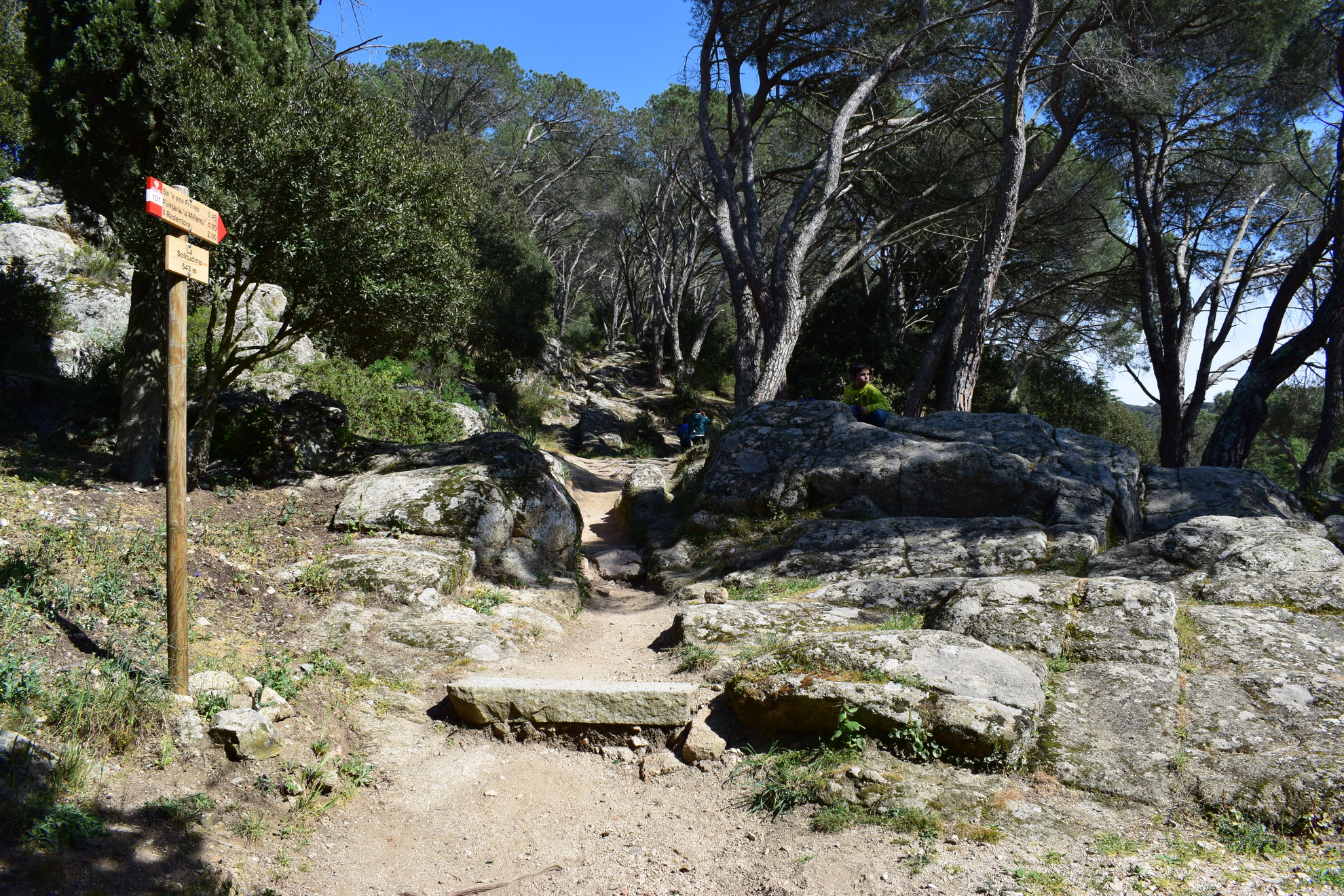
Mount Ortobene is framed by rivers to the north and south, including the River Cedrino, and valleys to the east and west, characterised by pre-Nuraghic remains such as the three domus de Janas of Maria Frunza, sasVrighines and Janna Ventosa. The ruins of the churches at saItria and santuJacu are more recent traces. The mountain peak is known as CuccuruNigheddu (955 metres), a panoramic point that looks from Mount Albo all the way to the Orune plateau.Explore deeper into the parks and visit SeddaOrtai by bicycle or skates, in the cool offered by pines and conifers, and admire a mushroom-shaped rock: sa Conca, a sheepfold carved out of an enormous rock. The park of Solotti, near the Casa Diocesana where spiritual retreats are held, is also of great interest. The park most closely associated with the mountain is at its peak: the Redentore, dominated by the statue by Vincenzo Jerace (1901), which is visited at the end of August each year by the Sagra del Redentore procession. Meanwhile, the city is a whirl of costume processions, singing and traditional dances from all Sardinian towns. As you descend, admire the valleys and mountains of Oliena, and on a clear day you can see as far as the blue gleam of the sea at Baronìa.
The mountain has always been dear to the Nuoresi, and especially to Grazia Deledda. From 1959 to 2007, the writer's ashes were held at the Chiesetta della Solitudine, the symbol of the area, built in the mid-20th century on the site of a 17th century church.