
Giara di Siddi
Seen from above it looks like an oddly inverted ‘T’ with steep high walls. But that alone is not what makes it so special: the southern end has a reddish hue and the interior is home to Nuragic and pre-Nuragic remains, including a Giants’ tomb considered the best preserved in Sardinia. The Giara di Siddi, also known as su Pranu, is one of three basalt tables of the Marmilla created between 2 to 5 million years ago by flowing lava. Over time, the weather eroded the sandstone rock while solidified layers of lava remained at a higher level to give origin to, aside from the Giara di Siddi, also those known as Serri and as sa Jara Manna (or Giara di Gesturi), the largest of the three and the habitat of the famous horses.
Su Pranu is 2½ km long and 1¼ wide with an altitude of 360 metres at its highest point. The plateau is covered in verdant Mediterranean vegetation, including several aromatic species. You will also see some cork-oak trees here. At the southern edge the wall features fissured columns, which over time have been covered by a reddish lichen. This colouration gave sa Corona Arrubia its name, located between Collinas and Lunamatrona, home of the Giovanni Pusceddu Territorial Naturalistic Museum. The views from the plateau are stunning and span from the Campidano plains to the undulating hills of Marmilla, all the way to the Gennargentu massif and, on a clear day, to the sea.
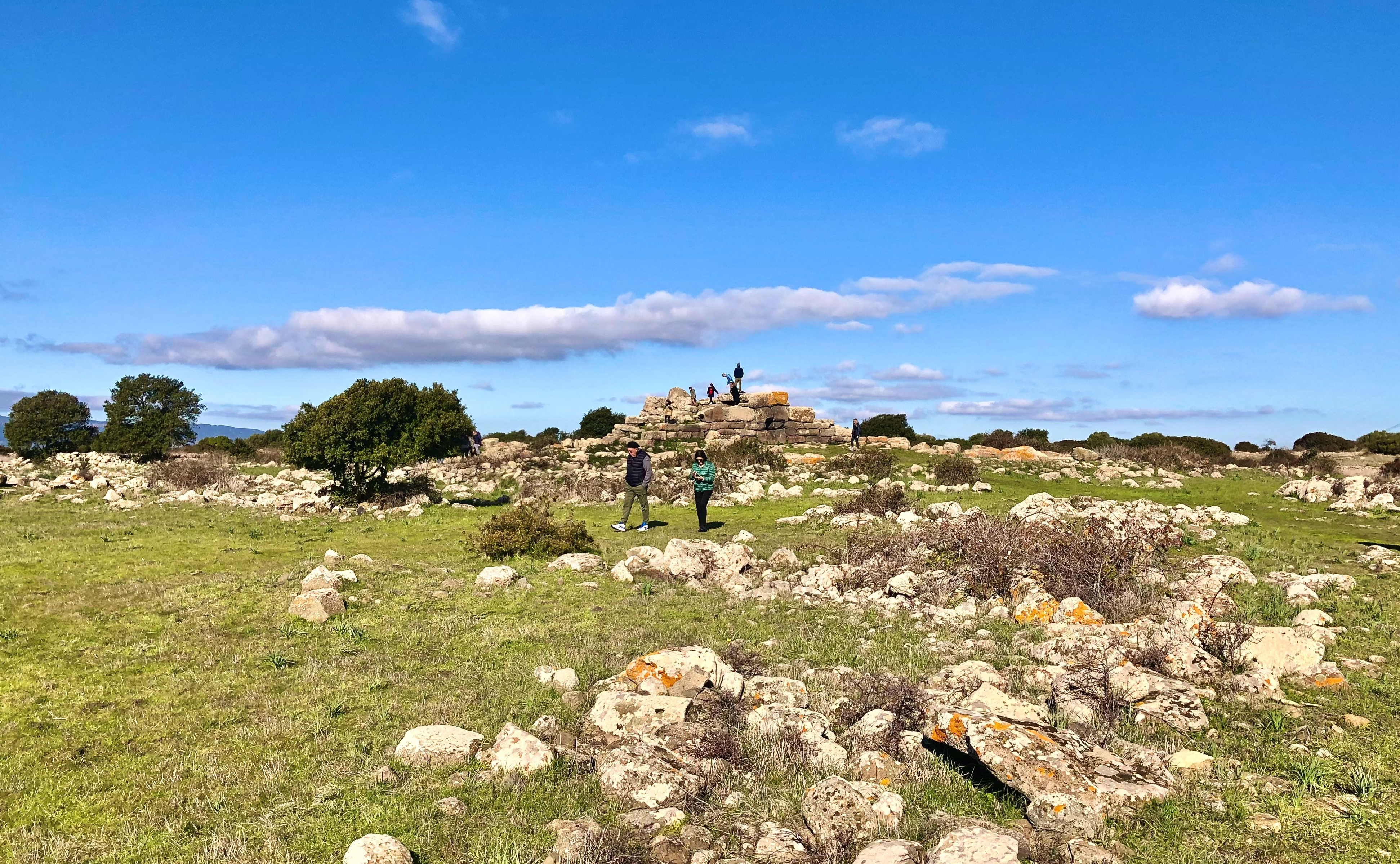
Its steep cliffs and elevation served as a natural refuge for pre-Nuragic and Nuragic populations. It thus stands to reason that the Giara di Siddi is home to some twenty nuraghes - some of which are right at the edge of the cliff - and various other archaic structures. The main landmark is sa Dom'e s'Orku, the Majestic Giants’ tomb located on the north-eastern side of the plateau. This megalithic monument, still in optimal condition, was made using row technology, laying huge blocks of dark basalt. The exedra has a diameter of 18 metres, while the body of the tomb measures 15. Not far away you will see the nuraghe and the sacred Conca ‘e sa Cresia spring. Originally built with a corridor layout, this nuraghe was then rebuilt as a complex tholos nuraghe. Inside it a crucible for melting sand into glass was found, possibly the oldest glass production site in Europe, perhaps even pre-dating ancient Egypt. On the eastern slope of the Giara is the Sa Fogaia archaeological-naturalistic park, well worth a visit. The upper part is home to the archaeological area, with a corridor nuraghe and a village where obsidian was worked, while a 'garden' extends downstream, with holm oaks, Mediterranean brush and hundreds of plant species, including aromatic and medicinal plants.
Archaeological Park of 'Monte Luna' and 'Sa Domu Nosta' Museum
A necropolis rich in grave goods, the traces of the village it depended upon and a modern museum in which artefacts from the two sites are kept all tell the story of how prosperous the Punic community that settled in the silent hills of Trexenta was and how it had a profound impact on a territory inhabited since prehistoric times that, after Punic domination, became the ‘granary of Rome’. The settlement came to be at the end of the 6th century BC. on the Santu Teru (Teodoro) high ground, two kilometres from the current municipality of Senorbì, near the confluence of two torrents, in a fertile and strategic area.
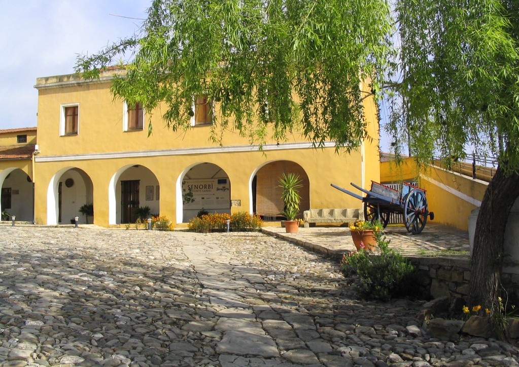
This place has been inhabited since the Late Neolithic period, as is demonstrated by fragments of decorated pottery and obsidian objects from the 4th millennium BC. The site was an outpost of Carthaginian penetration and, following the conquest of the island, it developed between the 5th and 3rd centuries BC as a thriving agricultural centre. Today, you can see the ruins of the Acropolis surrounded by a curtain wall and, on the outside, the remains of houses and other environments, such as foundry workshops perhaps. The inhabitants of Santu Teru were buried in nearby necropolises, a few dozen metres from the town, on the slopes of Monte Luna, where more than 120 tombs have been identified, mostly ‘well tombs’ with burial chambers on the sides containing one or two deceased people. On the floor of the hypogea, votive dishes have been made as well as recesses on the walls, on which you can also observe traces of murals painted in red ochre, showing geometric and linear designs. The cemetery also contains ns 'pit' tombs and simple ‘earthy’ tombs (the most ancient), 'cassone' tombs, burial recesses and enchytrismos tombs (in amphoras), for children. The shallower graves were marked with memorial stones or tumuli. The grave goods tell the story of a rich civilisation, one of well-being and progress: amphoras, jugs, plates, ointment jars, pots, lamps, coins, as well as Egyptian-inspired items and others imported from Greece and central Italy (4th-3rd century BC), which confirm the trade that took place with the central-eastern Mediterranean. In particular, the gold and silver jewellery bear witness to the splendour of the community: rings and pendants with beetles mounted in them, bracelets, necklaces, diadems, a large number of amulets made of different materials and bronze trinkets. The village was abandoned in the 3rd century BC. Later on, Monte Luna represented the most important village in Roman times. The grave goods and other artefacts from the archaeological park are on display at the sa Domu Nosta museum, located in a 19th-century ‘courtyard’ manor house of the village. The exhibition halls document the continuity of the settlements from the Late Neolithic period to the Middle Ages in the territory of Senorbì, including the Nuragic period, with artefacts coming from the impressive su Nuraxi of Sisini and the remains of the nuraghi of Simieri and mount Uda. A famous artefact found near the village is the miles cornutus, a bronze statuette portraying a warrior with very long horns on his helmet, kept at the National Archaeological Museum in Cagliari. Completing the exhibition, there is an ethnographic section. In addition to sa Domu Nosta, other ancient dwellings embellish the main town of the Trexenta region, a ‘dense’ tangle of narrow streets, within which there is the parish church of Santa Barbara, the seventeenth-century church of San Sebastiano and the church of Santa Mariedda, built at the end of the 13th century as a sanctuary of the villa of Segolay.
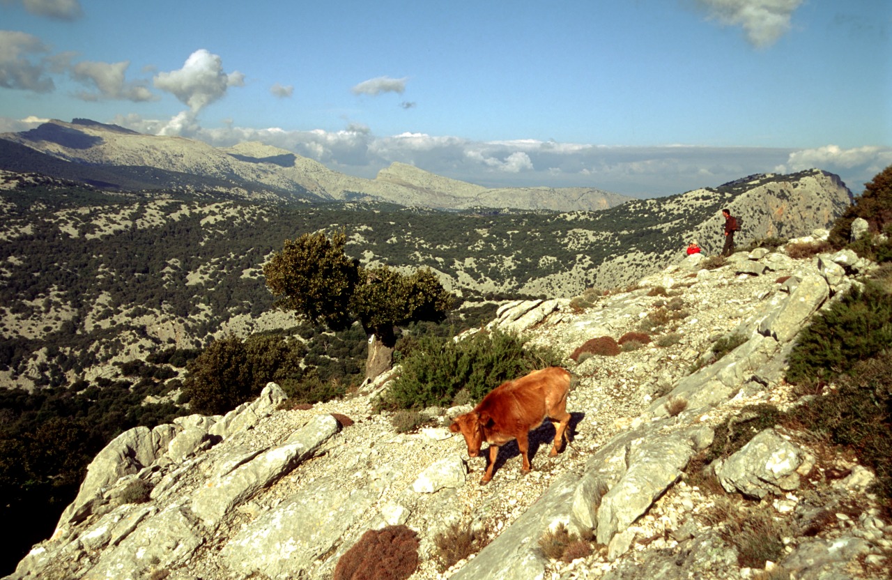
Supramonte di Urzulei
Barumini
In the centre of the Marmilla region, in the valley of the Mannu river, at the foot of the Giara, there is a special atmosphere: ever since prehistoric times, Barumini was the main centre of a very rich territory, with a population of approximately one thousand 300 inhabitants today. It is one of the most captivating places of culture on the Island. At the entrance to the residential area, there is a monumental complex that has made it world-famous: Su Nuraxi, the only archaeological site in Sardinia declared a UNESCO World Heritage Site (1997). Not only is it the most impressive (and most well-preserved) of the thirty Nuragic sites, but it is, above all, the most precious inheritance left to us by the Nuragic civilization. The archaeological excavations took place in the middle of the 20th century by Giovanni Lilliu. The cultural centre located a short distance from the nuraghe was named after 'the father' of Sardinian archaeologists and events, concerts, and archaeological and crafts exhibitions (permanent and temporary) take place here, in this incomparable setting.
Su Nuraxi, made entirely from basalt blocks, reveals two thousand years of stratification, from the 16th century BC to the 7th century AD. It is a complex nuraghe, consisting of a bastion with a central tower (18 metres tall) and four corner towers. All around it, there is a maze of 50 huts (dating back to the Final Bronze Age), wells and cisterns. Another trilobed nuraghe also bears witness to the prehistoric origins of Barumini. and is located in the centre of the village, dating back to the 16th century BC, the Nuraxi e' Cresia ('nuraghe of the church') that was unearthed during the renovation of Casa Zapata, a splendid residence of the Aragonese barons (who arrived in Sardinia in 1323), built in the mid-16th century and a rare example of renaissance-inspired Spanish civil architecture. The noble palace, along with the garden and courtyard, have been the site of a museum centre since 2006, inside which two towers from the Nuragic monument are kept and can be viewed from above, thanks to suspended walkways and transparent floors. In the archaeological section of the museum (managed by the Fondazione Barumini Sistema Culture) there are 180 artefacts on show, found in the nearby Nuraxi. The other sections, set up in the rural courtyard, are historical-archival and ethnographic, where the regional museum of the Launeddas, traditional three-piped musical instruments, is also located.
Barumini was also inhabited in the period that followed, as is evident in the traces of walls from the Roman era. In the Middle Ages it was annexed to the Giudicato of Arborea: there are still beautiful examples of religious architecture in its old town centre: the ancient Pisan church of San Nicola and the 13th century church of San Giovanni. The basalt plateaus of the nearby Giara, the home of the famous little horses with a mysterious origin, is the best place for trekking and bicycle tours: you will be able to observe them as the gallop around the centuries-old cork oaks, downy oaks, holm oaks, Mediterranean scrub and little temporary lakes of Is Paulis.
Coacuaddus
Its name means 'ponytail' and derives from the sinuosity of the coast with its numerous inlets. Coacuaddus is a long beach of white, coarse-grained sand, divided into two parts by a large rock and bordered by limestone cliffs. It is one of the pearls of the Island of Sant’Antioco, which will enchant you with the clarity and colours of the sea: the bay, thanks to the green hills that surround it, has turquoise and green hued waters. The sandy bottom remains shallow for several meters, making swimming easy and safe even for small children. You will have various services available, including ample parking and dining options.
From the sand towards the sea, the view opens onto the beautiful dunes of Porto Pino (in the territories of Teulada and Sant'Anna Arresi). Close to the rocks, the rich underwater life and the transparency of the water make for great snorkelling and scuba diving, and attract underwater fishing enthusiasts. The fields around let the scents Mediterranean plants waft gently over the beach. They are a destination for lovers of unspoiled nature, thanks to the proximity of the pool of Santa Caterina, where black-winged stilts and flamingos nest.
The beach is one of the pearls of the coastline of Sant'Antioco, where there are high cliffs of dark trachyte to the south and sandy shores to the north, including the beautiful Maladroxia. Do not miss the cliffs of is Praneddas (or arco 'dei Baci'), where you can stand on a terrace, 200 meters above the sea, to admire the whitewashed rocks of Cala Sapone and Cala Grotta and Cala della Signora. Capo Sperone is the farthest point to the south, with iridescent blue sea and expanses of pink peonies. Opposite lie the islets of Vacca and Toro, natural havens inhabited by rare birds. Portixeddu is the nearest beach to the village of Sant'Antioco, and is made of pebbles, like the nearby and larger Turri beach. Coacuaddus, on the other hand, is located about ten kilometres from the town, and is the main centre of the largest island of the Sulcis archipelago. The town is characterised by colourful houses, amazing restaurants and a tourist port, which give it a strong seafaring identity. Once it was known as Sulky, a Phoenician colony born in 770 BC, which later passed under Carthaginian rule and became a flourishing Roman city with the name of Sulci. Don't miss a visit to the sanctuary of Sant'Antioco Martire, patron saint of Sardinia, and to the Ferruccio Barreca archaeological museum which contains Phoenician-Punic finds.
Poetto di Quartu Sant'Elena
The stretch of the Poetto beach belonging to the town of Quartu Sant'Elena, in itself several kilometres long, runs from its eastern end at Foxi westward where it joins the Poetto of Cagliari. It is a wide band of fine white sand, which continues into the seabed. It is backed by a row of palm trees and other plant life, some patches of which also extend onto the beach. On account of its environmental value, clean and transparent waters and range of facilities and services, the beach has been awarded the blue flag.
The Poetto of Quartu Sant'Elena is in the locality of the same name, in the Municipality of Quartu Sant'Elena, and is also easily reached from Cagliari.

Mining Museum
The museum is located in Iglesias, in the basement of the "Asproni" Mining School, a fine Art Deco building. The school, whose opening ceremony was held on 13 December 1911, was built on the initiative of mining engineer Giorgio Asproni, who generously provided a 100,000 lire loan. The visit starts in the central hall and continues along the corridors which display the ore-carrying equipment, the explosives and the tools and machinery used for cutting and drilling the rock face.
The collection, which documents and illustrates the world of mining in Sardinia, includes a rare gallery of period photographs, minerals, and scale plastic models tracing the history of mining. Next comes a reconstructed small mechanical workshop and the visit to a flotation plant for ore processing. The centrepiece of the collection is the 2GH 'Montevecchio' excavator. It is also possible to visit the practice mine tunnel - restored and safety-tested - dug by the school's students themselves, starting from 1934, using various techniques. The different sections of the tunnel extend for about 300 m, partly beneath the school, partly in the grounds around it.
During WWII, the school basement area was used as an air raid shelter, infirmary and operating theatre, directly connected to the old Santa Barbara hospital.
The purpose of the museum is mainly to transmit to the new generations the memory of a past activity which was key in promoting civil and social advancement in this area. It is our duty to preserve this historical heritage, especially to recognise the role of the uncountable miners whose hard toil gave rise to a strong mining culture on the island.
The mining museum promotes appreciation, knowledge and protection of an immense cultural and historical heritage, created over more than two hundred years of mining history all across Sardinia. It includes reconstructions of life and work in the mine, displays of restored original equipment and machinery, and scale plastic models used by the school's students. It charts the key scientific human and cultural mining heritage that shaped the Iglesiente district.
Address: via Roma, 47 - 09016 Iglesias Phone +39 0781 350037 - +39 347 8333257 Managing Agency: Associazione Periti Industriali Minerari e Minerari Geotecnici
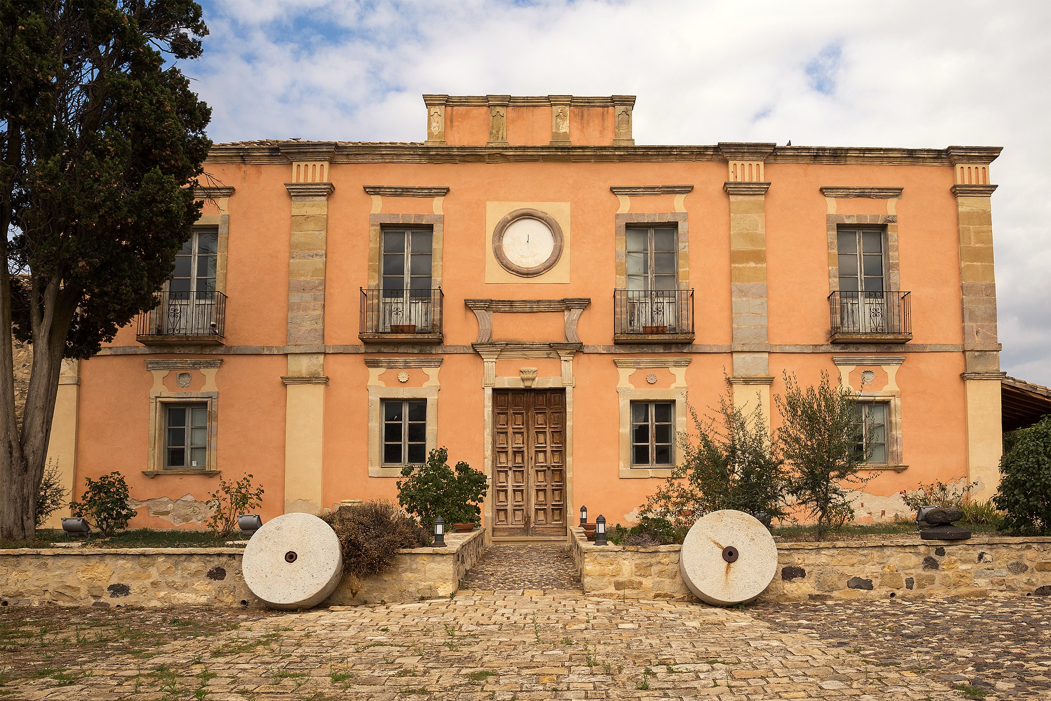
Villa Asquer
The prestigious 19th-century residential architecture preserves the memory of the family who not only constructed the house but established its agricultural activity and lived within. Villa Asquer, which was first a business hub and then a residence from 1920 to the end of the 20th century, belonged to the noble family of Ligurian origin. It is located in the historic centre of Tuili, a village in the Marmilla area at the foot of the Parco della Giara - part of which lies within its territory - within a splendid setting amidst cork trees, holm oaks, Mediterranean scrub, centuries-old olive trees, marshes, Giara horses and prehistoric sites.
The Asquer family became nobility following the marriage between Giovanna and Pietro Ripoll, the first Count of Tuili (1775). The villa was built in the mid-19th century using prestigious neoclassical forms attributed to the mastery of architect Gaetano Cima. The building was the fulcrum of the family headed at the time by the marquis and doctor Gavino Asquer, who managed the farm using innovative entrepreneurial methods.
The structure extends over six thousand square metres. At its centre is the main house, split over two levels. The ground floor contained the administration and servant rooms, whilst the first floor held the noble residence. The façade of the villa has large pilasters and a circular frame in the centre. In the large central courtyard, to the rear and sides, are the loggias, warehouses, olive groves, sheds and stables, once used for rural activities and now utilised for exhibitions and events. A must-see is the ‘Sala dello Scialle’, with its walls embellished with paintings centred on the embroideries of the shawls from Tuili, and the ‘Sala dei Cesti’, with authentic furnishings from the family’s legacy.
In the 1980s, the villa was purchased and restored by the municipality. Today, it is a cultural hub housing two cultural landmarks of the area: the olive and olive oil museum and the Sardinian musical instruments museum. The first, set up on the ground floor, illustrates the olive-growing tradition through images, stories and agricultural tools of the time, including a 19th-century oil mill and machinery from the second half of the 20th century. The museum honouring the musical tradition is on the first floor. An entire wall is dedicated to the rich collection of launeddas, an archaic wind instrument made with reed. Its sounds are diffused within the room with live melodies. Reed was also used to create the benas, sulitus and pipaiolus. One space is dedicated to percussion - tumbarinos, afuente, taulitas and matracas - with phonographs, gramophones, turntables and accordions.
The Villa Asquer complex extends over an entire block, overlooking the piazza of the parish church of San Pietro Apostolo, from which it is separated by a stone arch. The church, consecrated in 1489, has a single nave with three chapels on each side, with the third on the left being embellished with a starry vault with hanging gems, the only legacy of the original Gothic-Catalan layout. The façade concludes with a double crowning topped with an ‘Admiral’s hat’ form. The interior houses 19th-century marble decor and various works of art, including the altarpiece by the maestro Castelsardo, a 16th-century work considered the masterpiece of Sardinian Renaissance painting. In the historical centre, dominated by ‘courtyard’ houses characterised by portals from the end of the 19th century, another elegant neoclassical building stands out: Villa Pitzalis. One great cultural attraction is the ‘Sardegna in miniatura’ (Sardinia in miniature) park, where you can stroll amongst Nuraghe and dinosaurs on a reduced scale.

Capitana
Its sandy shore is divided between two coves. The first is smaller and crescent-shaped and the second is longer, stretching towards a rocky promontory. It is narrow, due to the continuous erosion caused by the sea, and runs for almost two kilometres alongside the locality of the same name, in the territory of Quartu sant’Elena, town with the third largest number of inhabitants on the Island. The beach of Capitana characterises a wide stretch of the Cagliari-Villasimius scenic route and appears with its bright colours at the end of a straight road, just before entering a landscape where the little villas give way to the greenery of the poplars, tamarisks and eucalyptus trees and also to small elevations covered in Mediterranean scrub and spectacular rocky cliffs.
You will have access to the beach via various detours from the SP 17 provincial road and you will find a strip of fine white sand that quickly makes way for the water’s edge, where shallow waters and a sandy seabed gently slope towards the open sea. The sea is transparent near the shore and the various shades of blue get darker as you look further out to sea, gradually becoming a deep blue. When the northwesterly mistral and southeasterly scirocco winds blow, Capitana becomes an irresistible attraction for surfers and also for kitesurfing and windsurfing enthusiasts, for whom there is no lack of schools and equipment rental services. To the west of the beach, there is a well-equipped marina that has two docks and was awarded the Blue Flag in 2020 as a tourist port. In this area, the seabed near the rocks becomes pebbly and, thanks to the transparent sea, snorkelling allows you to observe the abundance of marine animals.
There are plenty of services nearby, such as bar-restaurants, pizzerias, hotels, campsites and sports fields. Proceeding eastwards, there is a small beach of pebbles and rocky outcrops near the promotory: this is Baia Azzurra, ideal for relaxing, as it is cosy and private, thanks to the rocky stretches surrounding it. There is a handy wooden walkway, where you can sunbathe and enjoy the view. On the left, at the foot of the rocky spur, there is a part of the coast called the ‘cove of the pools’. You will be surprised by the transparency of the water, with its turquoise hues, where white rocks smoothed by the waves emerge.
You can also explore the historical and archaeological traces left in the area, by visiting the Carlo Baldi military battery, a fortification dating back to the 1930s, and the nuraghe Diana, a trilobate building from the middle of the 2nd millennium BC. According to popular legend, the Nuragic fortress guards a fabulous treasure: the booty accumulated by a pirate and his beloved, ‘La Capitana’, who waited in vain for his return, scanning the sea from these shores, and honoured by the local people with the name of the place.

Armungia museums system
A series of places narrate the history and culture of the Gerrei. Armungia is a 'open-air' museum that includes the ethnographic museum of sa Domu de is Ainas, the blacksmith's workshop, the mineralogical museum, the Emilio and Joyce Lussu history museum and the Armungia nuraghe dating back to the 5th-4th century BC, which rises majestically in the centre of the village - an almost unique case of Nuragic architecture within an inhabited area - and which can be accessed from the ethnographic museum. The nuraghe, which gives its name to the village that developed around it, is the starting point in the itinerary of the museum system: walking the stone streets of the village you will discover all the cultural sites, each with its particular historical, artistic and archaeological value, all 'mirrors' of the local identity.
Sa Domu de is Ainas, 'the home of work tools', uses a heritage of about 600 pieces to reconstruct the agro-pastoral culture of the communities of Sarrabus-Gerrei. The location is the 19th century town hall: the exhibition is divided into several rooms with illustrative panels, documents and images of the era, in addition to the case minime, three small stone houses that host the multimedia archives. The first two rooms display traditional clothes and jewels, and the tools of traditional female activities, especially weaving on the loom and bread making. The "agriculture room" is characterised by a large wooden solar calendar, which illustrates in Sardinian the phases of agricultural work; the "territory" room illustrates the life of the community, including cheese making. The "crafts room" is dedicated to the blacksmith's activities. The section refers to the Blacksmith’s forge, on ferreri, which you can visit in the museum itinerary through the streets of the historic centre: it is a small building of the early 19th century, and has been a craft workshop since 1928. On the ground floor you will find the shoeing frame, forge and courtyard with the sandstone wheels; on the first floor the work is recalled in its symbolic values with testimonies and vintage photos and the story of the Piedmontese family Vellini, who once owned the home.
The pride of the museum itinerary is the exhibition dedicated to Emilio Lussu and his companion Joyce Salvadori, which traces the personal and political experience of two key figures in Italian 20th century democracy. You can admire it in the casa del segretario, an imposing manor house built between the late 19th and early 20th centuries. The "photo room" traces the biographical events: childhood at Armungia - to which Emilio remained very attached, the Great War, the foundation of the Sardinian Action Party, the anti-fascist struggle, and the political experience of rebuilding Italy. The "multimedia room" offers films, period interviews and historical documents - in particular a manuscript letter to Piero Gobetti, in 1924; the "books" room is dedicated to Lussu's literary works. Other spaces host permanent exhibitions, including "Joyce Lussu: the path of a woman in the history of the 20th century".