
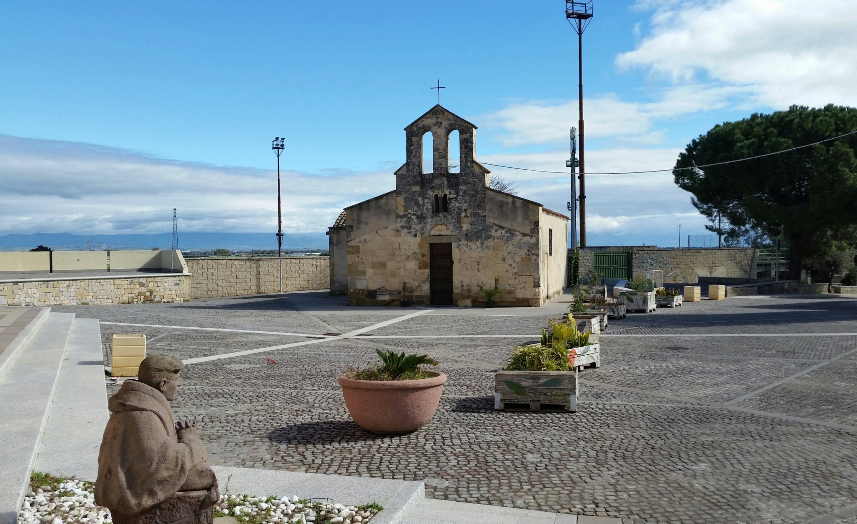
Decimoputzu
Set in the southern part of the Campidano plains, the town enjoys a very fertile soil crossed by several rivers, in particular the Rio Mannu. Decimoputzu is a town with a population of around 4500, and the name is first mentioned in the Middle Ages in the form of Decimopozzo or Decimo Pupussi when the territory was part of the Curatoria di Gippi within the Giudicato di Cagliari, and later the Reign of Sardinia, during the Aragonese-Spanish dominion. The town centre has two main churches: the parish church of Nostra Signora delle Grazie and the church of San Giorgio. The church of San Basilio is in the countryside outside the town. The surrounding land is characterised by greenhouses and vast fields of artichokes.
Its territory has been inhabited since the Neolithic. The most important nuragic sites are the nuraghes of Casteddu de Fanaris and Mount Idda, near which is a storage place where bronze items were found, including several swords. The ivory head of a Mycenaean soldier statue also dates to nuragic times, confirming trade with the Aegean civilisation, and found in the Mitza Purdia area. However, the most important finding is also the oldest, dating from the late Neolithic (3000 BC): the domu de Janas at sant'Iroxi, also known as the Warriors' Tomb, where 19 sword blades and arsenical copper, dating to the oldest nuragic phase (the Bonnanaro Culture, 1600 BC). The site, which was found by chance in 1987, was used for around 1500 years as a village and inhabited again in Roman times. It owes its name to the high number of skeletons (more than 200) laid in 13 chronological layers, and the rich warrior funeral goods found in the domu. These are now held at the National Archaeological Museum in Cagliari.
Decimomannu
To the west of Cagliari, after Assemini and on the edge of the State Road 130 leading to Iglesias, along a bend in the Riu Mannu, stands Decimomannu. A large town with over eight thousand inhabitants, it has always been a strategic outpost. Hence it was not by chance that the Via Caralis – Sulcis (Sant’Antioco) passed through Decimum in Roman times. Even the toponym is clearly of Roman origins, meaning ‘ten miles from Cagliari’. The first settlements in its territory are from the Neolithic period. A Nuragic village and a necropolis where bronze Punic coins were found bear witness to subsequent eras. According to the historian Casula, the 215 BC battle between the Romans and Sardinian-Punic people occurred near Decimo, during the Second Punic War. It was concluded with an overwhelming Roman victory, whose domination left several legacies, the most relevant being a bridge over the Riu Mannu in Bingia Manna, dated between the end of the 1st century BC and the beginning of the 1st century AD. Built in square limestone blocks, it is presmed to have consisted in thirteen arches. Today, three can be seen, along with the remains of other bases. Alongside are the ruins of a stone wall, an embankment for flooding. According to the Spano canon, “the bridge of Decimo was much nicer than that of Porto Torres”, with those of Sant’Antioco and Gavoi being the only Sardinian constructions still standing. Remains of another minor bridge are in the area of Su Meriagu. Other Roman remnants are those of the aqueduct, evidence of the first public water supply. In the Middle Ages, the village passed to the Giudicato of Cagliari, with many of the Giudicato residing there. From the Aragonese period, there is the sarcophagus of Violante Carroz, daughter of Giacomo, viceroy of Sardinia, held safe in the village cemetery.
The most important religious building is the parish church of Sant’Antonio Abate in Gothic-Catalan style, dating back to the 16th century. With a single nave, there are three chapels on each side, a cross vaulting on the right side and barrel vaulting covering the left. Access to the presbytery is via a majestic arch with a starry vault. Of great importance are the Gothic capitals and the baptismal font. The façade is embellished with a Gothic portal, a rose window and – as of 1922 – a triangular tympanum. To the left stands the high bell tower.
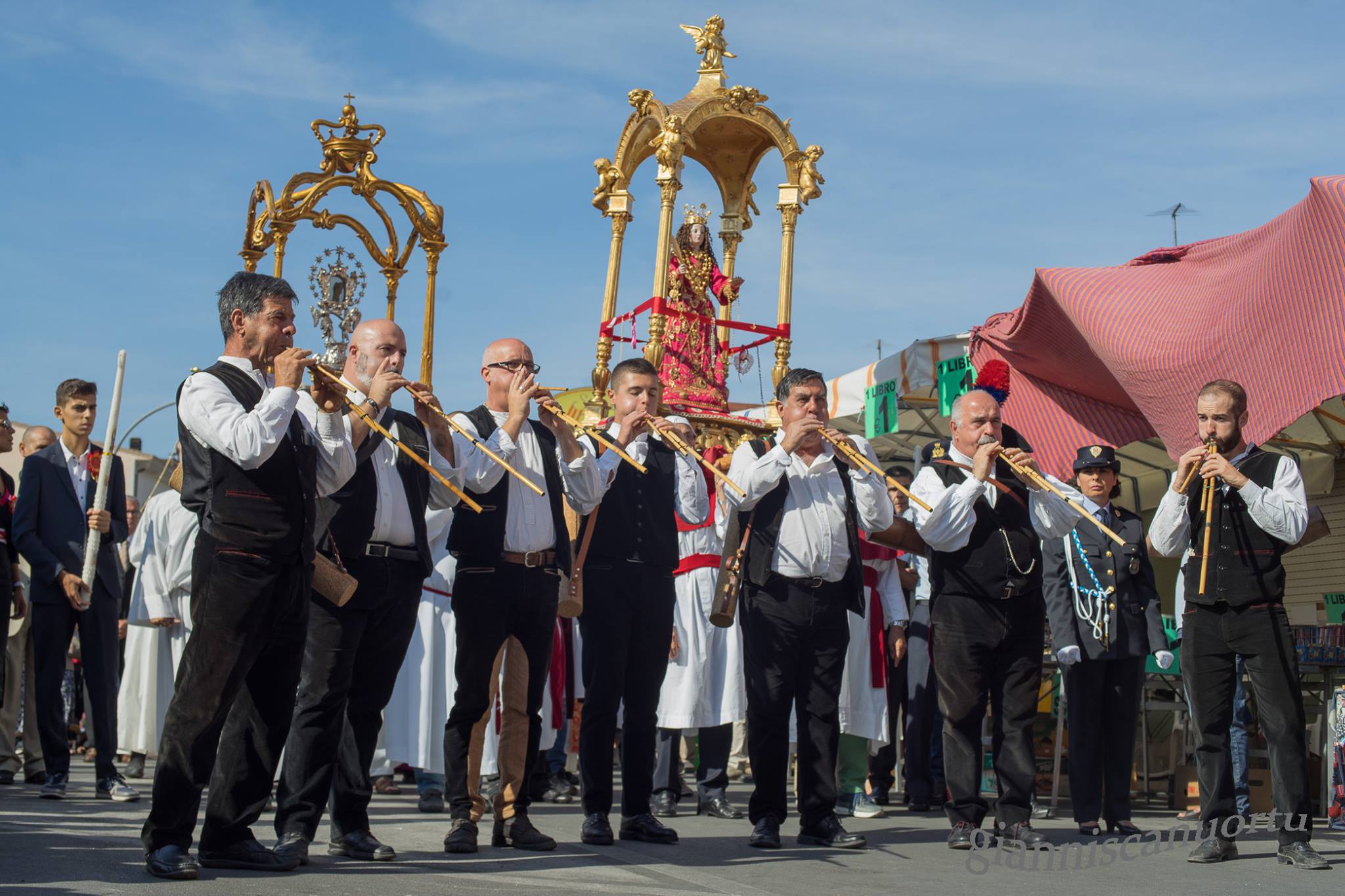
Sant’Arega (Santa Greca) has been recognised and venerated for 1700 years in Decimo and throughout Sardinia. According to tradition, the plaque, considered to be authentic (4th or 5th century), preserves a relic found in 1633. She died a martyr at twenty years of age, perhaps during the persecutions of Diocletian and Maximian (304 AD). There is information on a church dedicated to her in 1500, built on an older one (perhaps from the 13th century). In 1777, a new church was constructed at the southwest entrance of Decimo, with an altar and a pulpit in polychrome marble. It has undergone various changes and a complete restoration. The church remains isolated throughout the year, coming to life for a week in early October on the occasion of the feast in her honour that attracts thousands of people from all over the island.
Basilica di Santa Croce
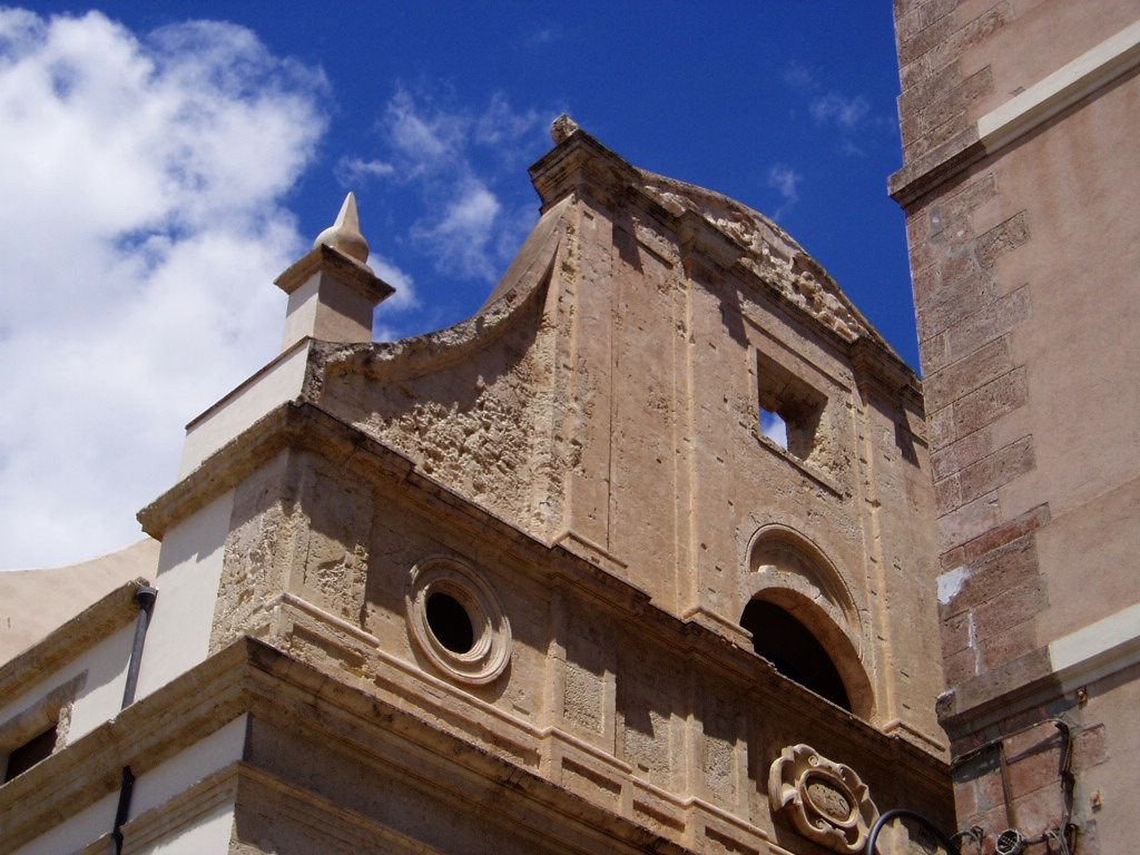
This temple is a symbol of the religious and socio-cultural integration of the Castello, the fulcrum of Cagliari, from the 13th and 19th centuries. The Basilica di Santa Croce can be explored whilst strolling through the heart of the city, upon entering into the medieval quarter from the Saint Remy bastion. After crossing the Torre dell’Elefante and going along the Santa Croce bastion in the direction of the Ghetto degli Ebrei, a stretch of a small piazza can be spied, preceded by a few steps and enclosed by the houses of the former Jewish quarter. Here, one faces the monumental façade of the basilica, which was reopened for worship in 2007 after decades of restoration. It is difficult to photograph the entire slender façade, given that one can only take a limited number of steps backward within the churchyard. The feeling of majesty increases once inside, with a single nave that is barrel vaulted and decorated with faux ceiling coffers by Ludovico Crespi.
There are three chapels on each side, also barrel-vaulted, decorated with baroque altars in polychrome marble, with sculptures and paintings from the 17th and 18th centuries. The presbytery is enriched by a high altar, guarded over by a wooden Crucified Christ, and closed by a semi-circular apse, on which Antonio frescoed the Saints Mauritius and Lazarus (1842). The façade is divided into two levels, with the lower one opening the portal, surmounted by a curved tympanum, and the upper one being distinguished by pilasters and bordered by two obelisks. Another peculiarity is the two bell towers. One is parallel to the façade, the other is near the presbytery, with a square-barrelled tower and an oriental dome. The history of the church, originally having been a synagogue, is intrinsically linked to the village, once the Giudaria of Cagliari, which reached its maximum expansion under Aragonese rule, before Ferdinand II banished from the territories of the Crown any Jewish and Muslim people who did not convert to Christianity (1492). The synagogue became a Catholic church and was granted to an archconfraternity, whose noble members were committed to comforting those condemned to death. In 1564, Archbishop Parragues, in order to promote cultural growth in the city, called upon the Jesuits, who were granted the church and adjacent houses, which became the College of the Company of Jesus. Thanks to the legacy left to them by the noblewoman Anna Brondo, the building was expanded and radically transformed. An inscription on the façade shows that the works were completed in 1661. At the end of the 18th century, Pope Clement XIV suppressed the Jesuits and the complex passed to the State. Finally, at the beginning of the 19th century, King Vittorio Emanuele I promoted the church to the rank of Masterful Basilica and entrusted it to the knightly order of the Saints Mauritius and Lazarus, to whom it still belongs. Throughout the centuries, the former college rather became the Monte di Pietà, a printing house, a Court, Court of Appeal, Faculty of Literature and, today, of Architecture.
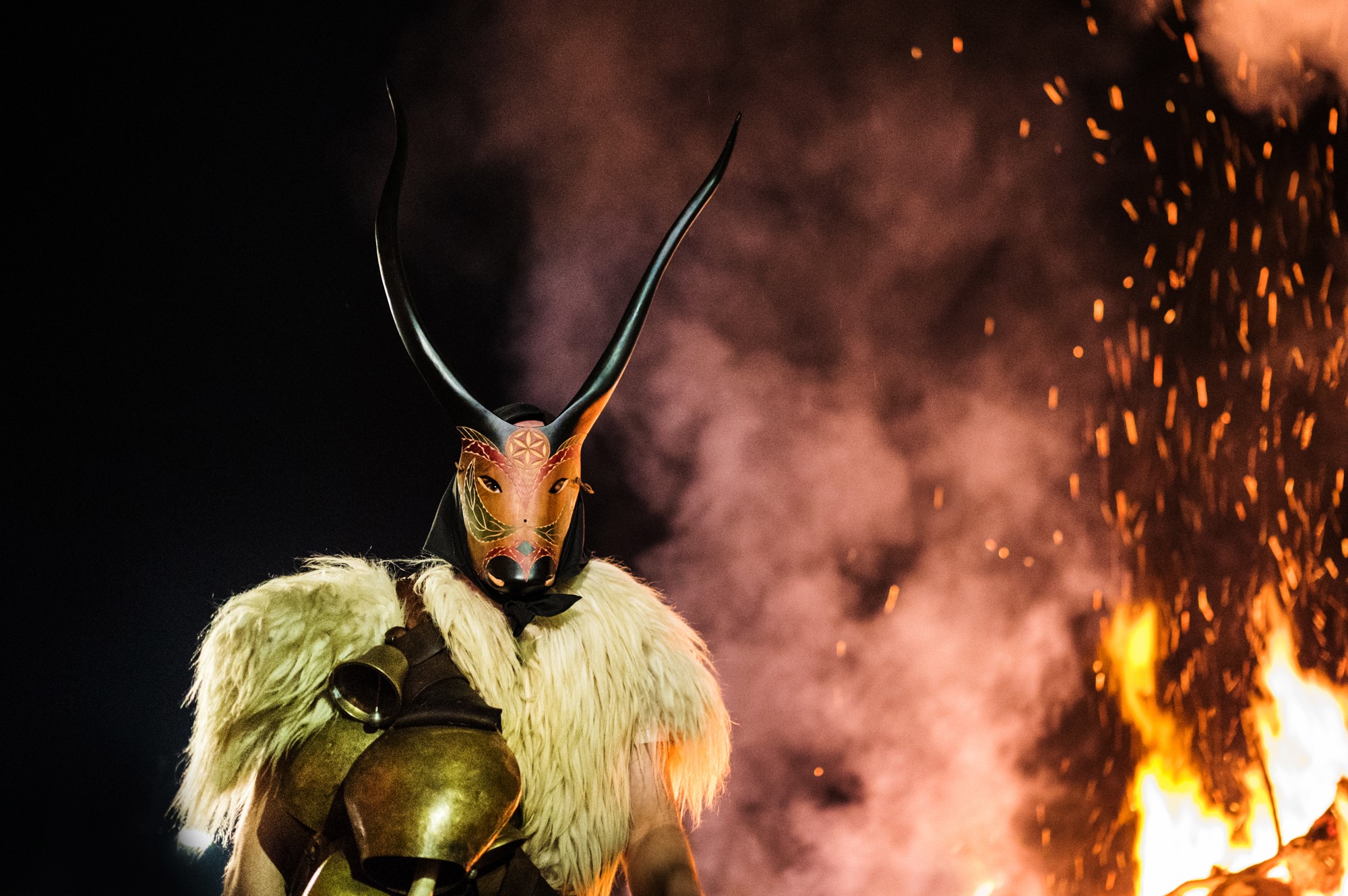
The mysterious beauty of Carnival in Sardinia
With the lighting of the spectacular bonfires in honour of Sant’Antonio Abate, an ancient, solemn rite performed in many of the island’s towns, Sardinia reawakens its spirit and enthusiasm during Carnival. Su Karrasecare has many different sides to it and each community celebrates it with its own traditions, vocations and spirit. January 17 marks the beginning when the bonfires of Sant’Antonio are lit, and Ash Wednesday marks the end, with the beautiful, heartfelt celebrations in Ovodda. They are the first events of the year to enliven winter with ages-old rituals. Sacred and profane, passion and identity, exciting rhythms and magnificent settings like the one at Gavoi, where the tumbarinos (drummers) play. In every town, from the North to the South, you can enjoy typical carnival delicacies like fava beans and lard, pistiddu and coccone, zeppole (doughnuts) and fine wine.

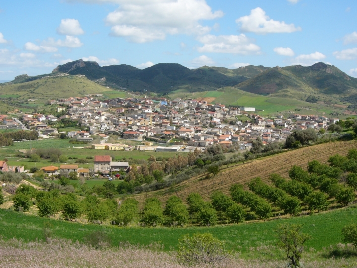
Nuraminis
It extends on a plain dotted with moderate, isolated limestone hills inhabited since prehistoric times. Nuraminis is a town of 2600 inhabitants in southern Sardinia with a tradition of cereal farming, which is reaffirmed by Cereal Festivals in mid-June and by hand sowing in December. Its territory is characterised by rare geological features, destinations for climbing enthusiasts, which can be reached via mountain bike or horse trails. The most notable of these are the lava domes of Mount Leonaxi, the fossils of Genna Siustas and Mount Murroni and the limestone cuesta of Coa Marfine, known as the limestones of Villa Greca. A natural monument that stands out from the surrounding landscape is a kilometre-long rocky ridge, the remains of an ancient coral reef. These geological features also contain archaeological sites. From the top of Matta Murroni, you can admire megalithic walls and by cuesta peak, the ruins of Sa Corona, a proto-nuraghe dating to 3000 BC, a unique example of prehistoric architecture. At the foot of Leonaxi, there is a multi-layered site (‘courtyard’ nuraghe or fortified complex), with walls constructed using a series of different techniques. Santa Maria is another such ‘multi-layered’ site. Inhabited from 3000 BC to the Early Middle Ages, it consists of the ruins of a village, a burial ground, a holy well and a church. In Genna Siutas, stands Funtana ‘e Siutas composed of four large slabs with a hole for drawing water, and a staircase for accessing the pool. Just 500 metres away, there is the Serra Cannigas complex. A corridor nuraghe associated with a tholos and a fortified structure that takes advantage of the rockface on which it is set to form an artificial terrace. On the eastern slope, traces of sheds can be seen. Artefacts found here show that the area has been inhabited for thousands of years. Small vases, fusaroles and copper ornaments now on display at the National Archaeological Museum in Cagliari were found inside two shaft tombs located in the same hill. On another hill there is a Nuragic complex called Nuraxi and an adjacent village. Sa Grutta is a Neolithic site. It is a large cave that opens onto smaller chambers resembling a Domus de Janas.
The Parish of San Pietro Apostolo has great architectural value. It was built in the Catalan Gothic style that was later altered, with the bell tower (thirty metres high) and the starred vaulted ceiling in the apse remaining unaltered. The niches and Byzantine age marble fragments have historical interest. The chancel and the lateral chapels hold wooden and marble altars, statues and paintings, including an altarpiece depicting the Mysteries of the Rosary (17th century). The Church of San Vito Martire, in Villagreca, is just as charming. Built in the 9th century, it is a rare example of Byzantine architecture on the island. It was reconstructed in the 18th century in the Catalan style. It houses the 16th century “sorrowful crucifix” from Flanders and two 18th century altars, one wooden and one marble. In the countryside, there is a small Romanesque Church of San Lussorio Martire that may have been built in the 12th century by Vittorini monks.
San Nicolò Gerrei
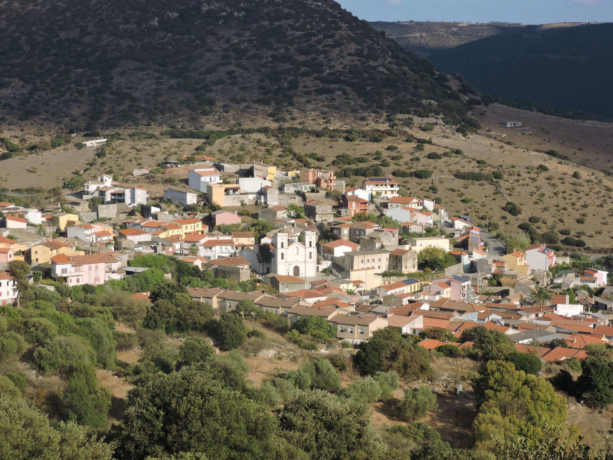
San Nicolò Gerrei reaches 370 metres in altitude, in an area rich in plateaus, south of the river Flumendosa. Populated by 800 inhabitants, San Nicolò Gerrei is the main town in the territory from which derives its name, inhabited since the Neolithic period and with traces of well-established settlements in Carthaginian and Roman times. Farming and mining are the main sources of income, along with the cultivation of grains and vines. The name of the village also comes from the patron saint, Nicola, celebrated twice a year, in mid-May and early December. The existence of the current inhabited area is attested by documentary sources from the 13th century, it being referred to as Padule (or Pauli), names which remained in use until 1863. It derives from the Latin palus, with the inhabited area arising in a basin subject to stagnation and containing numerous springs.
Until the mid-16th century, Gerrei was covered with forests and called Galilla, in the ancient site of the Galillenses who in 69 AD - as evidenced by the large bronze inscription Esterzili tablet - were forced to withdraw from these territories. Considered to have descended from the pre-Nuragic and Nuragic peoples, from which derive the megalithic circle of Mnt’Ixi, the Nuragic Monti Taccu and Su Nuraxi, the great sacred hut of Forreddus and three sacred springs, including the well-preserved Su Musuleu. Noted 19th-century archaeologists speak of Su Putzu de Santu Lacci, a well temple about four kilometres from the town. Behind it gushed a spring of water collected in a well, perhaps once a sanctuary facing towards the ‘healing’ divinity. In 1861, a relic was discovered in its ruins that bought fame to San Nicolò - a bronze column base with trilingual inscription (Latin, Greek and Punic) from mid-2nd century BC. Originally, it was perhaps a crowned cylindrical altar. The three texts are a votive dedication - by a certain Cleon rendered thanks to the god Eshmun (correspondent to the Greek Asclepius and Latin Esculapio) for restored health. The presence of ruins and fragments of ceramics at Santu Iacci ranging from the Nuragic to the Roman age and Punic coins proves that the spring was in continuous use. Today, there are no traces of the temple. Whilst other important artefacts remain from the Roman era, including a treasure of almost 400 coins minted from between 117 and 251 AD, many Roman finds were brought to the Peninsula by the Savoy in the 19th century. One example is an ornately-sculpted Pentelic marble sarcophagus - Apollo the Citharist is represented, accompanied by Athena and surrounded by the nine Muses - amongst the most beautiful to have ever been found in Sardinia. It was first brought to Genoa, then, at the request of Carlo Felice, transferred to a castle in Piedmont. In 1915, the canonical Francesco Lecca made mention of another sarcophagus. The necropolis from which they came would have been discovered in 1932 in Bingia Manna.
Segariu
Its name derives from s’ega ‘e riu, meaning the ‘marshy river valley’, or from segau de s’arriu, meaning ‘cut in two by the river’, because of the town’s location in a valley crossed by two tributaries of Flumini Mannu. Segariu is a town of 1200 inhabitants close to the border between the Marmilla and Trexenta historical regions with characteristics of both: the rolling hills covered pine groves and Mediterranean shrubs of Marmilla, and the rugged hills interspersed with cultivated, fertile, flat stretches of Trexenta. The town is known for traditional kaolinite and limestone shaping, with clay bricks and roof tiles being produced. In the centre of town, the Museum of Clay, a testimony to the importance of this tradition, is dedicated to salvaging this craft, which has defined the town for centuries. The exhibition is an accurate reconstruction of a local roof tile workshop. Here, visitors can observe and participate in workshops lead by clay working masters. The Perdas e Minas exhibition also focuses on this activity, atypical with respect to the surrounding Campidano farming reality, with period photographs, working tools and accurate reconstructions of production processes. Another demonstration of this tradition is the Tebajus event in July, which in addition to activities linked to the local production of fired roof tiles, includes craft shows and an exhibition of typical products.
The area has been inhabited since the Bronze Age as seen from the Franghe Morus Nuraghe and the four-lobed Nuraghe of Sant’Antonio, a nearby symbol of Segariu. Built using limestone and marl blocks, it has one central tower and four external towers oriented along the four cardinal points. The area immediately to the east of the nuraghe and its interior have produced artefacts of a large and interesting Late Punic settlement. A Giant’s Tomb was likely located nearby, just as the small country church dedicated to the same saint built between the 12th and 14th centuries in Late Romanesque style over a well temple most probably coeval with the Nuragic settlement. It is one of the many Sardinian expressions of continuity between different cultures and religions. The celebration in honour of Saint Antonio is held in early September, where in addition to religious events, a tasting of typical local products and dishes is held. A 17th century Parish of San Giorgio Martire stands in the town’s centre. It has a presbytery topped with star vault typical of the Catalan Gothic style. The Feast Day of the church’s patron saint is celebrated in late April with religious rituals and music shows.

Setzu
‘‘Sitting’ at the foot of the Giara, a basaltic plateau that is home to an unparalleled natural oasis, Setzu is a small agro-pastoral village of about 150 inhabitants, the smallest in southern Sardinia and one of the smallest in the number of residents of the entire island. Its main income comes from farming and shepherding. It is known for its meats, cheeses, wine, mushrooms and snails: the foundations of local culinary specialties, which visitors can taste in mid-August, at the festivals of the Fregola and of Su Pani Indorau. The town name means ‘old’ (from su becciu, su belzu/elzu or s’etzu). The oldest of the nearby towns, it was part of the Giudicato of Arborea in the Medieval Period.
The town’s territory covers an area of about 250 hectares on the south-west slope of the Giara, as well as the rolling hills of the Marmilla. The town’s symbol is a unique species of wild horse: the Giara horse. They can be observed close up as they gallop through forests of cork, downy and holm oaks, wild olives and Mediterranean shrubs. The area is perfect for horseback riding and biking.
The town centre has retained its traditional look with stone Campidanese homes, characterised by arched doorways and internal courtyards (lollas). The buildings are arranged around the Parish of San Leonardo, built in the 13th century in Romanesque style. Fallen into ruin, it was rebuilt in the 17th century with obvious Baroque details. Next to the church, stands a bell tower with a square cross section: evidence of the original Romanesque structure. The church’s patron saint is celebrated in early November. The town’s other church is the Church of San Cristoforo. Setzu has close ties to tradition: the community’s most anticipated event is the Feast of Sant’Ignazio da Laconi in late August. The town’s cultural heritage includes the ex-grain bank and the Filo di Memoria multimedia museum, set up in 2011 in a converted historical residence in the heart of the town. It talks about prehistoric archaeology and the history of the town, using tools that include fables, across three rooms. The exhibition route leads visitors in a ‘live encounter’ with the Mother Goddess and Janas in a virtual voyage from 5000 to 3000 BC, a period during which the area was populated, as seen from the Domus de Janas, Domu ‘e s’Orcu and Grutta sa Perda. The remains of Nuragic towers testify to human presence during the Bronze Age. Numerous Roman ceramic items were also found near s’Uraxi Nuraghe. At Corte Muros, sections of walls and roofing dating to the same period were unearthed. While at Nuraxi ‘e Setzu, the ruins of a Roman Imperial village were found.
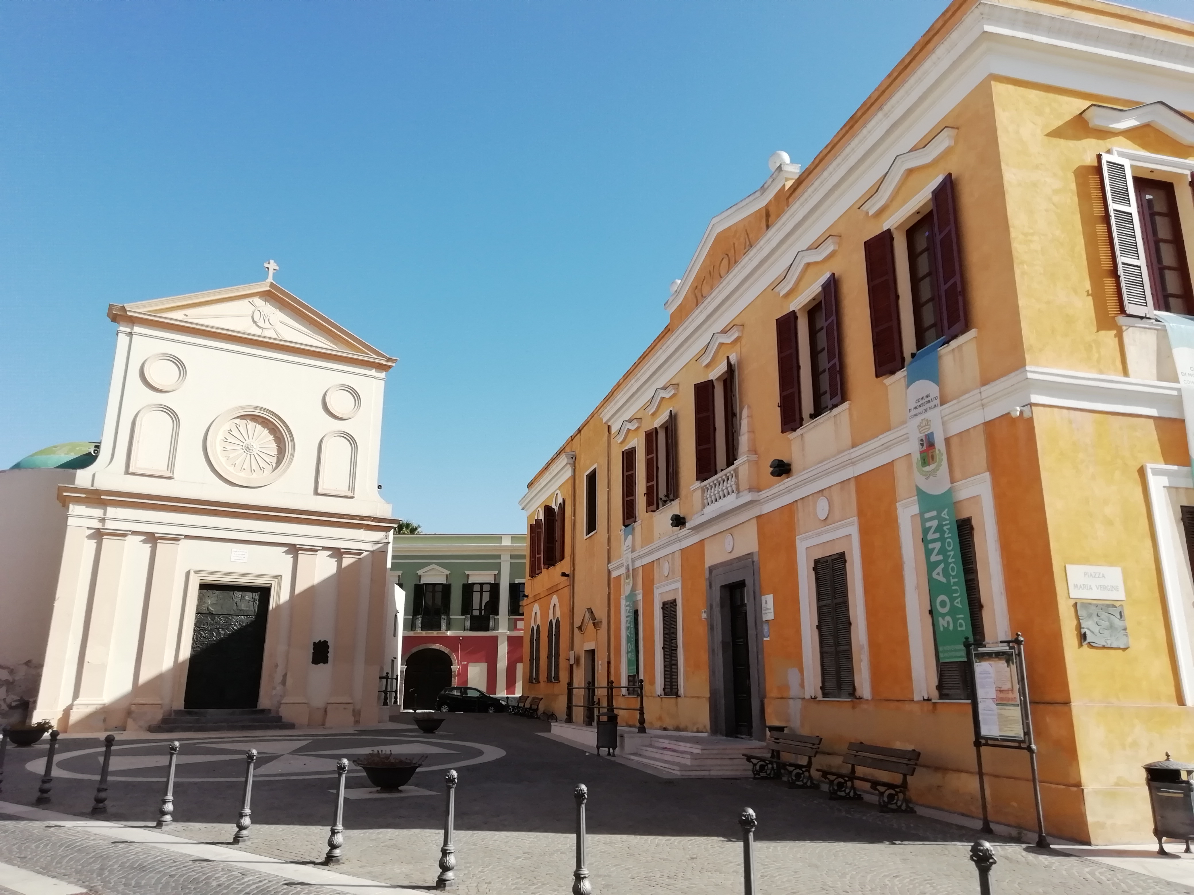
Monserrato
Monserrato lies in the southernmost part of the Campidano province, near the Molentargius-Saline Regional Park, within the metropolitan city of Cagliari. Monserrato is a city with 20,000 inhabitants, whose inhabited area, through the municipality of Pirri, is seamlessly joined with that of the capital, from which it became independent via a referendum in 1991. In Sardinian, it is known as Pauli (swamp), already the name in medieval times. It then became Paùli Pirri. In 1881, the name changed to Paùli Monserrato. Just seven years later, via royal decree, this became Monserrato, deriving from the Madonna of Montserrat.
The old town is characterised by narrow streets overlooked by typical Campidanese houses in Ladiri (mud-brick), with Spanish loggias and wooden portals. The winemaking tradition lives on, as is testified by Sagra della vendemmia (Grape Harvest Festival) at the end of September. Its communal winery is the oldest in Sardinia (1924), with nuragus, monica, moscato and nasco wines produced here. From the end of the 20th century, construction was remarkable, with new and modern neighbourhoods being built. Along the road to Sestu, the Cittadella Universitaria was built, being a vast complex connected to the city by the Ponte Strallato (bridge) on the state road 554, the only one on the island. Inside the citadel is the Museo Sardo di Antropologia ed Etnografia (Sardinian museum of anthropology and ethnography). The other main exhibition is the Museo delle Ferrovie della Sardegna, dedicated to the construction and operation of historic stations and railway lines, with an area in which old-time steam locomotives and vintage carriages are kept. There is also the Trenino Verde, a tourist service that departs from Monserrato and heads to Mandas and Isili.
To be admired in the heart of the city is the parish church of Sant’Ambrogio (whose patron saint is celebrated on 7th December), in late Gothic-Catalan architecture, built between the late-15th and early-16th centuries. Whilst there was originally one nave, today the interior has three, with the central one being wide and tall, composed of pillars that unite in ogival arches. The side aisles are barrel-covered with six chapels on each side. On the high altar in gilded wood and polychrome marble (1705), scenes of peasant life and Christian symbols are carved in bas relief. The baptismal font is the work of Catalan craftsmen of the 15th century. Particular and unique in Sardinia is the conformation of the diagonal buttresses of the façade. The earliest information on the Church of Santa Maria de Pauli dates back to the 12th century. Its Greek cross layout is surmounted by a 19th-century dome. It is only open in September to celebrate the Virgin of Montserrat, just prior to the harvest rituals. Within are housed works by artist Gianni Argiolas, including the ‘Painting of the Procession’. Another illustrious local is painter Cesare Cabras (1886-1968), whose works are on display inside the town hall. A stand-out amongst the Monserrato traditions is the luxurious traditional women’s clothing.
Furtei
Furtei stretches along the western side of a hill between Medio Campidano and Marmilla. A small town with 1,600 inhabitants, it lies around 40 kilometres from Cagliari and has an economy based on agricultural activities. It was an important town during Medieval times. The territory includes a high concentration of Nuragic remnants, with the ruins of five Nuraghe structures. A short distance from the town is the village of Nuraxi, documented since the 17th century. Now almost entirely uninhabited, here once stood the ancient parish church, the town church of San Biagio, dating back to the 13th century. A tradition event taking place on Palm Sunday sees the mayor deliver La Palma della Passione to the parish priest, who carries it in a procession. This ritual is a symbolic act in memory of the peace established between Furtei and Nuraxi (1605) through the intercession of Baron Santjust, who gave a palm branch to the families in each of the two villages.
Today, the parish church is the Chiesa di Santa Barbara, with the saint’s feast day celebrated at the beginning of December. Inside there is a painting depicting the Crucifixion of Jesus, an act that is ‘relived’ during Holy Week, on the Friday prior to Easter. The parish church, former parish church and churches of Santa Maria della Natività, of San Narciso (from the 13th century), of San Sebastiano and of the Sacra Famiglia come to life on the occasion of the sacred rituals, from the Friday of the Passion prior to Palm Sunday, with Sa Pintadura De Sa Prama, through to the Easter ritual De Su Incontru, followed by the processions of Our Lady of Sorrows and Palms, for the preparation of Christ and for Su Scravamentu (the deposition of the body of Christ). In addition to these holy events, there are also many religious festivals, including the bonfires of San Sebastiano (19th January), the celebrations of Sant’Isidoro, protector of farmers (mid-May), of San Biagio at the end of August, with the evocative procession of the return of the saint, and of San Narciso (end of October), with the intonation of the rosary with alternating choirs and the invocation of Is Coggius, all in the Sardinian Campidanese dialect. The main festival is held in the second week of September for the birth of the Virgin.