
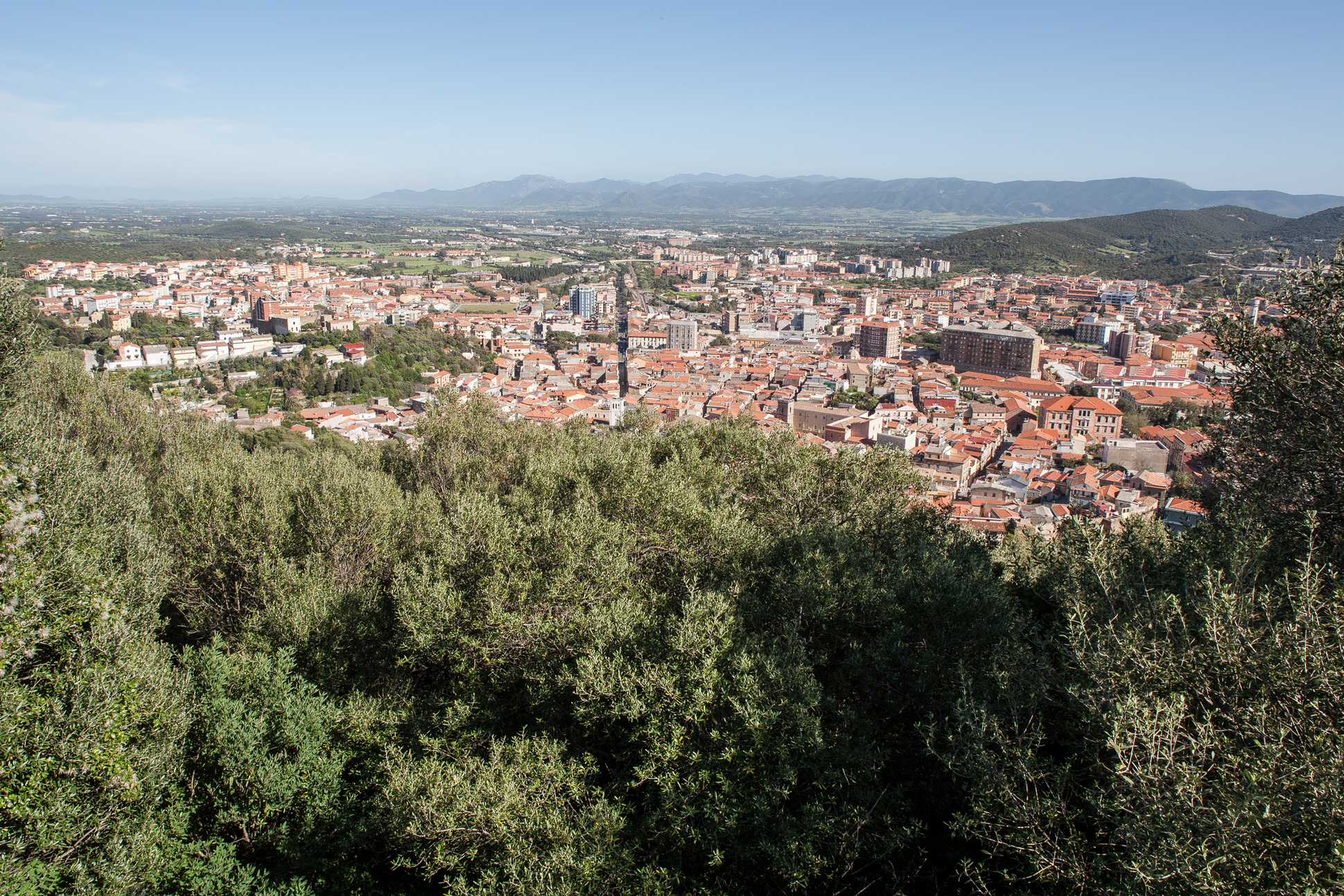
Iglesias
Its name derives from Iglesiente, the territory that was the protagonist of the Sardinian mining past, of which this town was central. It is populated by 27 thousand inhabitants, as well as being the bishop’s seat and heir of the ancient diocese of Sulcis. In Spanish, ‘Iglesias’ means ‘churches’. Not by chance - in a place with a glorious past, especially during the Catalan-Aragonese domination (when it was a royal city), the celebration of the rituals of Holy Week take on forms and colours of Spanish tradition. The Processioni dei Misteri (Processions of the Mysteries) on Holy Tuesday and Friday are the most evocative expressions. Amongst the churches, the Cathedral of Santa Chiara (14th century), the Madonna delle Grazie, the Chiesa del Collegio, the Jesuit ‘temple’, and San Francesco, one of Sardinia’s most intact and significant examples of Gothic architecture and which houses a retable from 1560, are all worth a visit.
Also noteworthy are the ruins of San Salvatore, one of the few Byzantine cruciform buildings (9th-11th century). The mining route of Santa Barbara sets out from Iglesias, with 24 stops over 400 kilometres, to be covered on foot or by mountain bike on a discovery of the history and devotion of the Sulcis. Another tradition to be experienced is the medieval historical procession held in mid-August, featuring musicians, flag-throwers and people in medieval costume in the historic parades of the area.
For over a century, since well before the mid-20th century, the mines have been the main source of income for the Iglesias locals. Today, they form the heritage of industrial archaeology in the Geominerario di Sardegna park, recognised by UNESCO. The Museum of Mining Art, housed in the ‘Asproni’ institute, an Art Nouveau building from the early-20th century, and the Museum of Machines retrace their respective evolution through a collection of minerals, plastics, reconstructions of mining environments and displays of original machinery. To explore the mines ‘from within’, there are guided tours in the fascinating Monteponi, one of the most important extraction plants in Italy, in Nebida, amongst the wells, tunnels, piers and miners’ houses (inhabited by 3,000 people in 1910 and today a ghost village), including the Lamarmora washery (1897), in Masua and Porto Flavia, futuristic and revolutionary work that allowed for the direct boarding of minerals, a dock suspended in the middle of a rocky wall, from which a 600-metre tunnel was suspended above the sea. Alongside the wonders of the Iglesias coast are the long Porto Paglia, the stacks of Masua and Pan di Zucchero, a 132-metre high natural monument forged by time, the beach of Porto Flavia and the Canal Grande di Nebida, a valley where one-hundred-metre walls drop vertiginously, guarding over a stretch of blue and emerald-green sea. The steep coast with enchanting coves is ideal for photo shoots. After the sea, the delights of the local cuisine are to be explored, including tuna, potato and mint ravioli, and sweets made with almonds that are all beautiful to look at and pleasing to the palate.
San Pantaleo
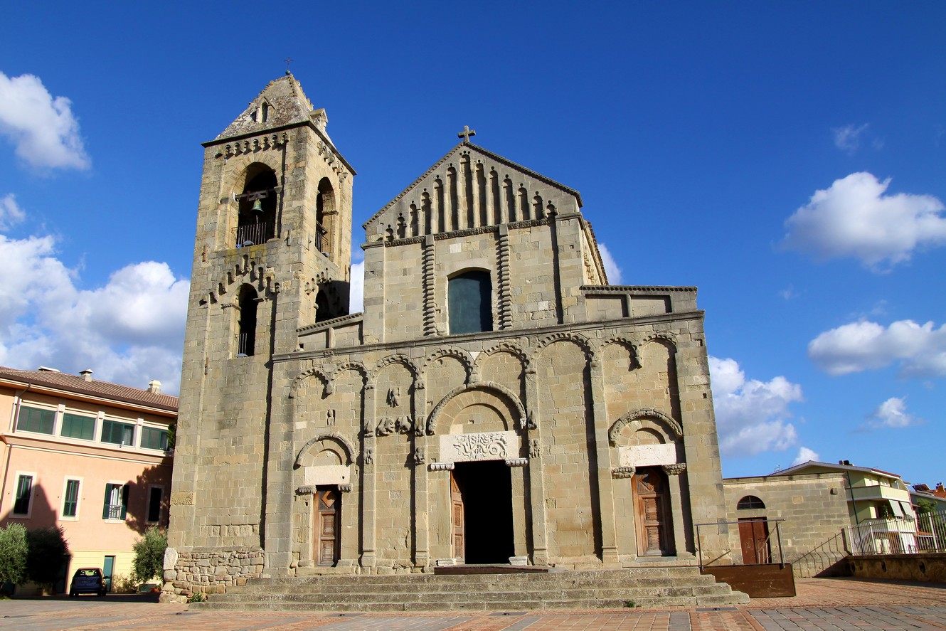
Shapes and decorations are intact and form a harmonious combination of various influences and building phases. The church of San Pantaleo, patron of Dolianova, a town situated in the historical territory of Parteolla, to few tens of kilometres from Cagliari, is unique in the Romanesque medieval panorama of Sardinia, constructed between the beginning of the 12th century and 1289, the year of its consecration, as is documented in the epigraphs of the portal and a painting in the apse. It was built in what is now the historical centre of the village, which has always been a place of early Christian worship, as is confirmed by a 5th-6th century baptismal font, kept in the presbytery, and the remains of a 10th century church pertaining to the Early Middle Ages. The temple, a cathedral of the diocese of Dòlia up until its suppression (1503), will strike you not only for its architectural majesty, but also for its sculptures and paintings.
The former cathedral was built in sandstone, based on Romanesque features, with Gothic details dating back to the latest reconstruction. The layout with three naves, the cross-shaped pillars and several parts of the masonry date back to 1170. Externally, you can admire the façade and the bell tower adorned with pilasters and little arches and accented by geometric decorations and mythological patterns. Before crossing the entrance, over which there is a Roman marble on which snakes are engraved, on the left side you will notice a sarcophagus mounted on columns and over which there is an arch. Then you can lose yourself in the internal exuberance: large arches open up in the walls, supported my massive pillars with 'Romanesque' capitals, sculpted with scenes from the New Testament and "Gothic" images with crochet-style leaves.
In the main body, there are medieval frescoes: that with the Tree of Life, a painting made up of three circles, with Christ on the cross depicted in the central one and saints and prophets in the other two, a Saint Francis giving a blessing and the famous Retable of San Pataleo, dating back to the end of the 15th century. The work is made up of six pictures: in the centre, the saint, who was a doctor, carries out miracles and an unusual and precious Madonna of the Book. In the four lateral ones, there are scenes of the martyrdom, which took place in 305. The celebrations in honour of the patron saint take place in two periods of the year: two weeks after Easter and at the end of July, with sacred ceremonies and cultural events. The origin of Dolianova is linked to the former cathedral, which emerged at the beginning of the 20th century by the unification of the ancient villages of San Pantaleo and Sicci San Biagio. Its countryside, renowned for the Vermentino wine-producing vineyards, have been inhabited since prehistoric times, to which the settlements like Sa Dom'e S'orcu and Mitza Salamu bear witness.

Nuraghe is Paras
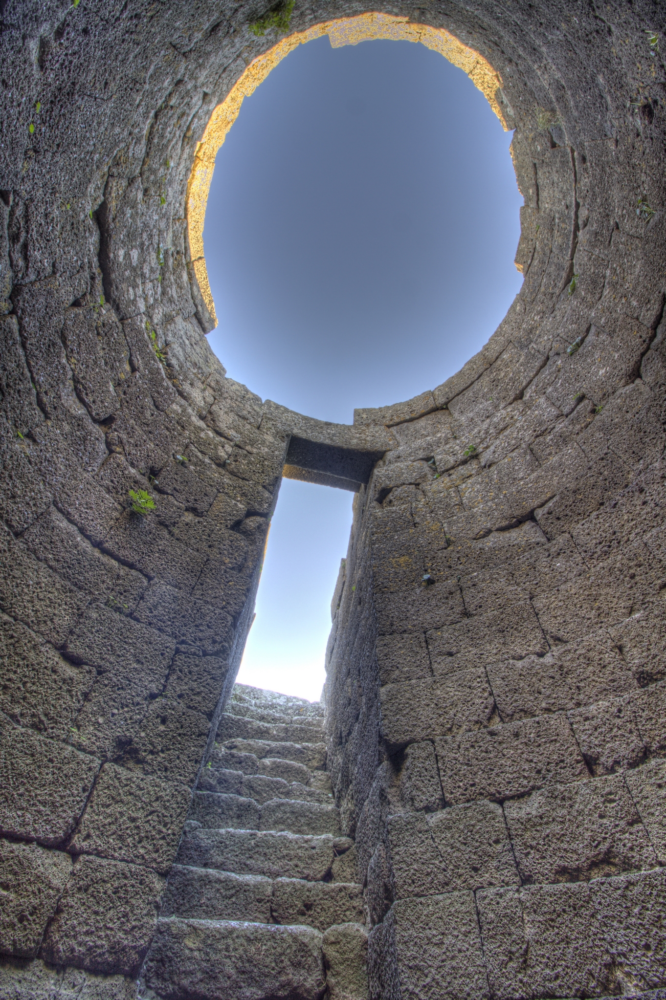
"The largest and most harmonious of the Sardinian tholos, which closely resembles the breadth of those magnificent and splendid Peloponnesian acheas of the mid-2nd millennium BC". The 'father' of nuragic archaeology Giovanni Lilliu praised the singularity and elegance of the 'false dome' vault of the central tower of the nuraghe is Paras. The prehistoric fortress and the surrounding village stand on a limestone hill in a dominant position on the immediate northern outskirts of Isili. The name means 'the friars', because the land where it stands belonged to the Piarists from the 17th century, who built a monastery here. It used to be called su Idili, like the town where it is located.
The monument, built with blocks of marly limestone (white and brown) arranged in horizontal rows, consists of a central tower surrounded by three secondary towers, connected by curtain walls. It has a long and varied history, with three main phases: in the Middle Bronze Age (15th-14th BC) it was built as a single-tower nuraghe; in the Recent Bronze Age (13th-12th BC) it became a 'tancato' nuraghe (Sardinian term for courtyard), with the addition of a tower and a corridor to connect them; in the Final-Recent Bronze Age (12th-11th BC) it became a trilobate nuraghe, with the addition of two more towers and a thirty-metre-long, two-metre-thick wall around it, also with towers, which protected a village of huts. The whole area was later inhabited in Roman (2nd-3rd AD) and Byzantine (6th-7th) times: traces of Roman and early medieval huts have been found, together with ceramic finds and a bronze buckle depicting a man between two Latin crosses.
The main circular tower is almost thirteen metres high and consists of two superimposed floors. The lower one is preserved and can be visited. The inner chamber has 37 rows of stone for a height of almost twelve metres: the tallest and most harmonious in Nuragic Sardinia and second only to the Tomb of Agamemnon (at the time). It is accessed through a monumental corridor and has special features: a raised rectangular entrance, a steep chamber staircase leading to the first floor and, in the centre, a deep and finely crafted well. And above all the perfect and majestic tholos roof. The hallway also gives access to the open-air, half-moon courtyard (17 square metres), overlooked by the entrances to the three angular secondary towers (one of which can be visited) which, connected by rectilinear curtain walls, form a thrilobe bastion. On the right wall of the corridor there is a small room with a very steep staircase, which led to the top of the 'second' tower and curtain walls.
In addition to is Paras, there are around 50 nuragic sites in the Isili territory: the Asusa park, with a nuraghe of the same name, is worth a visit. There are also pre-Nuragic remains and Roman settlements (Bidda beccia, the village of Biora and the bridge over the riu Brabaciera). The area is also home to Lake San Sebastiano, an open-air park where you can go hiking, fishing, canoeing, biking and climbing.

Santadi
It is located on a fertile plain, divided by the Mannu river into two urban centres. Santadi is a village in Lower Sulcis with three thousand 500 inhabitants and a strong wine-making tradition which has reached international heights thanks to Carignano wine. The cheeses and delicious typical local breads baked in wood-burning ovens are also excellent: civraxiu, su coccoi, bread with Ricotta cheese and gerda (pork fat). The pastries vary according to the festivities: macaroons, gueffus and pardulas. The honey and olive oil are also excellent. The upper part of the village extends around the parish church of San Nicolò, dating back to the 15th century and rebuilt in the nineteenth century. In the centre, you will discover Sulcis customs in the house-museum of Sa Domu Antiga. Also worthy of a visit are the Book Museum and the Doll Museum. The event par excellence, at the beginning of August, is the Matrimonio Mauritano (Mauritanian Wedding), with a ceremony based on ancient rural traditions. Decorated floats pulled by oxen accompany the bride and groom wearing traditional dress, followed by a wedding procession with folk groups from all over the Island. At the end of the ceremony, auspicious rituals are celebrated.
The Santadi woodlands are part of the Gutturu Mannu park, where one of the largest green areas in Italy lies (35 thousand hectares): holm oaks, cork oaks, yew trees, holly and Mediterranean scrub, ideal for trekking. In the district of Pantaleo, a village once linked to mining activities, you can walk through a forest with centuries-old trees. The Sardinian deer and the fallow deer live here and are protected. In this setting of lush vegetation, there are natural caves. Unique in the world are the Is Zuddas grottos, a splendid underground setting created by the incessant action of water over 600 million years. They open up in the limestone depths of Mount Meana and stretch for 1650 metres, about one third of which can be visited. The evocative rooms stand out due to their size and variety of concretions: stalactites and stalagmites, flowstones and aragonite. Other caves to examine are those of the Campanaccio (Cowbell), of the Capra (Goat) and, above all, Su Benatzu (or Pirosu, named after its discoverer), inside which a Nuragic temple was discovered. On the back wall, a stalagmite acts as an altar. At its feet, there is a well, where two thousand metal objects were found (daggers, swords, bracelets, rings, necklaces, domestic tools and ex-voto offerings). You can admire them in the village's archaeological museum, along with other sites in Lower Sulcis, the major one of Santadi being Pani Loriga. It has stratifications from the 4th millennium BC to the 8th century AD: here, there is a civil and military Phoenician-Punic settlement (7th century BC), with necropolises, built on an impressive Nuraghe and on various Domus de Janas. It continued to be frequented during the Roman and Byzantine periods. There is endless evidence of the Nuragic age: the Tomb of Giants of Barrancu Mannu stands out. It dates back to the 14th century BC and was built with large pinkish-yellow granite blocks.
Sanctuary of Santa Vittoria
Protected by a precipice to the south and a rocky wall to the north, the sanctuary of Santa Vittoria stretches for three hectares, among various relics from the past, in the Giara di Serri. It is an evocative place where you will observe the evolution of the Nuragic civilization in the Bronze Age and until the beginning of the Iron Age, from the corridor nuraghe (1500 BC), followed by the 'classic' nuraghe (14th to 12th centuries BC), until the area became (11th-9th centuries BC) the symbol of cultural religiosity and a cultural and commercial crossroads of all the Sardinian peoples and not only: Etruscan, Phoenicial and Cypriot objects, found in the excavations, are confirmation of exchanges that took place with distant peoples.
Four groups of buildings can be identified. The first is the sacred area, consisting of the shaft temple dedicated to the water cult: it is the main building with carefully finished basalt blocks. A paved entrance hall, with a counter-seat and altar, and a flight of steps leading to the well. Nearby, there is the 'hypaethral' temple with two altars, that could be reached via a 'sacred way'. From here, a passage will lead you to the 'priest's hut', while, in the north you will find that 'of the chief' with an atrium, seats and a room. Another architectural nucleus is the 'celebrations enclosure', a social-commercial area, for celebrations, business and a place for 'strangers' to stay, where you will recognize porticoes, rooms with benches and seats, a collective kitchen, a 'smelters enclosure' and 'the market', or nine rooms with seats and slabs for wares.
A third group of buildings consists of the huts, among which that 'of the double baetylus' - from the sacred artefact found inside - and of the houses of the 'fireplace' and of the 'guardian'. Lastly, you will find a fourth complex, in which the 'enclosure of the tortures' and the 'Curia' with approximately 50 seats: here, it is possible that the heads of the various Nuragic peoples of central Sardinia gathered in a federal assembly. The excavations unearthed artefacts made by the Nuragic artisans: models of nuraghi-altars, taurine protomes, fragments of arms, bracelets, rings, axes, ceramic objects and, above all, bronze statuettes (votive offerings) with human and animal forms and means of transport. The 'federal' sanctuary was also in use in the Punic-Roman era. The sacredness continued on into the Byzantine era: the Church of Santa Maria della Vittoria was built and it was later rebuilt in the 11th-12th century: this is the Christian sanctuary that gave a name to the archaeological area.

Goni
Goni is surrounded by oaks and holm oaks in the valley of the river Flumendosa, in the middle of two mountain slopes. Goni is a village with 500 inhabitants, in whose unspoiled territory are important prehistoric sites, especially the archaeological park of Pranu Mutteddu, nicknamed the ‘Italian Stonehenge’ (albeit it older than the English ‘original’). It is the ideal destination to explore the nature, archaeology and geology of the Gerrei area. Just 500 metres from the town, in the locality of Peinconi, is a site preserving a Graptolite, a rare fossil from the Palaeozoic era. Goni is a town replete with centuries-old craft traditions, in particular those of cork and weaving.
A few kilometres from the village, amidst a cork tree wood, is one of the most extensive archaeological areas extending across 200,000 square metres. Evoking prehistoric Sardinia, it consists of the Pranu Mutteddu and Nuraxeddu sepulctures, linked to a small cluster of huts nearby, and by the Domus de Janas of Genna Accas, exceptionally surrounded by megalithic circles (concentric rings of stones, sometimes with the paraments having terraced steps), such as those of the Dolmen of the Allée Couverte di Baccoi variety. In the tombs, the funeral chamber is accessed via a corridor formed by slabs covered with lintels. The internal chambers are circular or elongated, depending on how many sepultures they hosted, with there being no lack of individual chambers. The covers were tabular or pseudo-domed. The grandiose Tomb II features an entrance, an antechamber and a funeral chamber unearthed in two rocky blocks. Excavations have discovered pots, arrowheads in obsidian and various objects that date the complex to the end of the Neolithic era (3200-2800 BC) with ‘infiltrations’ up to 2600 BC. Above or near the necropolis are large groups of menhirs, mysterious sandstone blocks with elongated shapes. In all, there are about 60 of the proto-anthropomorphic type, being the highest known concentration. They are distributed in pairs or small groups, sometimes over burial architecture. One alignment consists of twenty perdas fittas, oriented according to the projectory of the sun. Later remnants, dating back to the Bronze Age, include the Nuraghe Goni, on top of a plateau overlooking the town, from where a splendid glimpse of Lake Mulargia can be admired. The building in limestone blocks is a circular mono-tower, being ten metres in diameter and eight metres in height. The tholos room is intact, being circular with three niches arranged in a cross pattern. At the end of March, the enthralling Giornata di Primavera (Spring Day) takes place in the archaeological park. The most cherished festival in the town is celebrated in late July, with the Sagra Patronale di San Giacomo Maggiore, a feast dedicated to the patron saint and including a solemn procession through the streets of the town.
Sanluri
Sanluri lies on the Medio Campidano plain, bathed by the Flumini Mannu, with an ancient castle nearby. This town has less than 9,000 inhabitants. Its historic centre is within the medieval walls, whilst the road system fans out beyond the fortifications. In ancient documents, it appears as Sellori, a reference to the richness in grains that has always characterised these lands, it being the shortened version of Logu De Su Lori (wheat territory). The current name is an alteration honouring the former patron saint, San Lorenzo. The ‘true’ history of the village began in the Middle Ages, thanks to the fertility of the territory and its strategic position. From the 1300s, it became a fortified town on the border between the Giudicati of Cagliari and of Arborea. The original village was built around the castle, the only one in Sardinia that is still habitable, being that of Eleonora d’Arborea, although it is uncertain if the ‘Giudicessa’ herself ever stayed there.
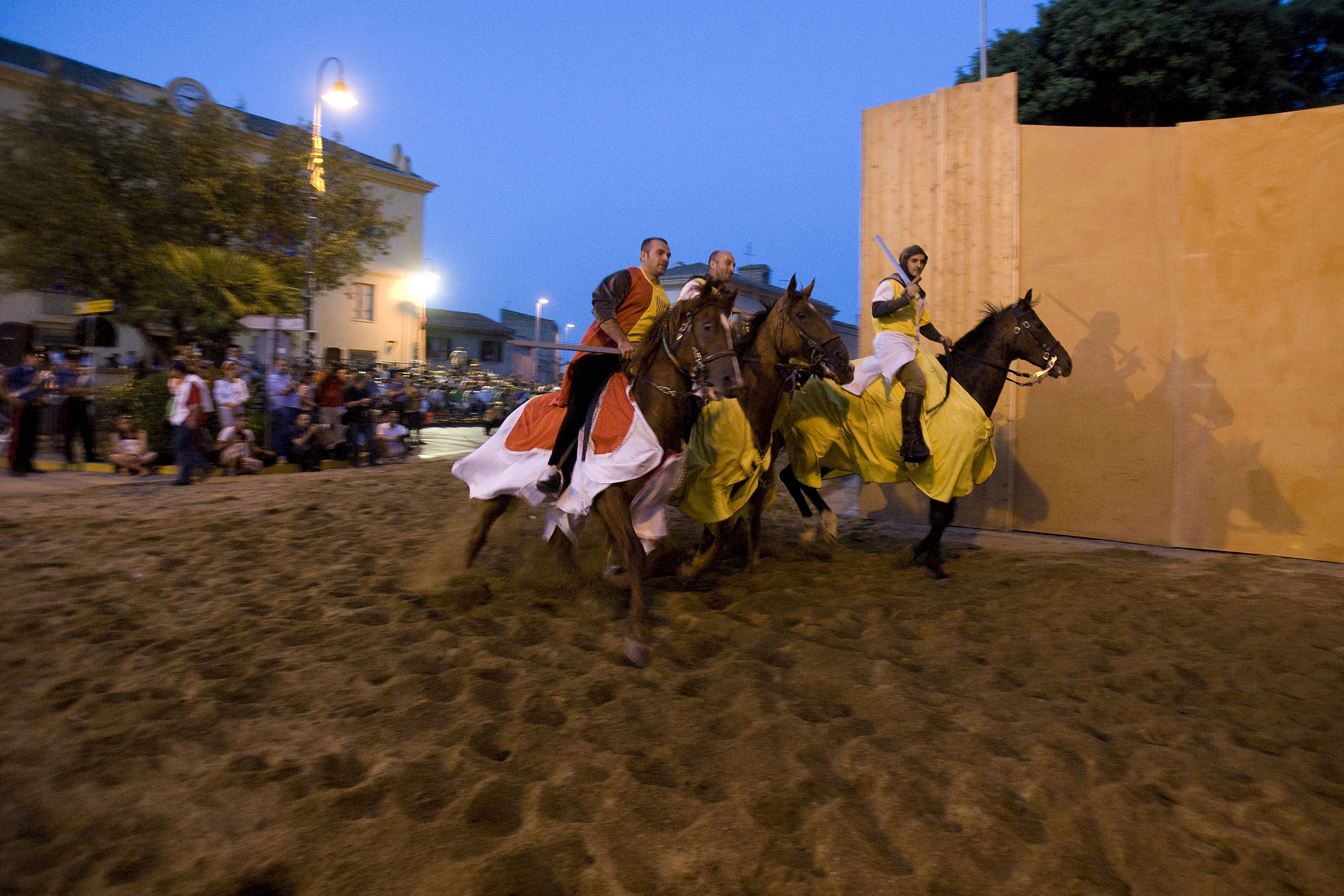
The structure, with four towers connected by massive walls, was built between the 12th and 14th centuries. Upon taking possession in 1409, Peter IV of Aragon had it fortified, just 27 days before it became the scene of a bloody and decisive battle between the Spanish Army and the Sardinian Giudicato. Every two years at the end of June, there is a historical re-enactment of the event. Subsequently in Sa Battalla, the Spaniards finally conquered the fortified residence, before then undertaking its expansion. Since 1920, after having passed to the hands of various feudal lords, it has been the property of the Villasanta. In 1927, General Nino Villasanta restored the fortress, where the Museo Duca d’Aosta was then established. Here, sensations of medieval and renaissance life can be experienced in the general’s studio, in the Gondi rooms, in the rooms dedicated to hunting rooms, in the Queen’s quarters, in the Napoleonic drawing room and in the living room militias. Two museum rooms preserve relics and documents from the world wars and East African Campaign, whilst a third room safeguards a collection of 400 wax works and a fourth is dedicated to the feudal district. In the Franciscan convent is the Museo Etnografico dei Cappuccini (Ethnographic Museum), also rich in points of interest. The iconic religious building is the parish church of Nostra Signora delle Grazie, built at the end of the 18th century atop a pre-existing church from the 14th century, once a cathedral. It houses the medieval altarpiece of Sant’Anna by the Maestro di Sanluri. Amongst the other places of worship are the medieval churches of San Pietro and San Rocco, the first parish church of San Lorenzo featuring a wooden ceiling with the heads of lions and dragons, and that of San Martino, the doors of which are opened for the festival held on 11th November. Then, at the end of September, there is the Festa del Borgo which reinvokes the historical atmosphere of the town. As for food and wine traditions, Sanluri is famous for its Civraxu, an exquisite bread made from durum wheat flour.
Samassi
Crossed by the river Mannu, Samassi is one of the most productive agricultural areas of the Medio Campidano thanks to the fertility of its land. Samassi is a town of 5,000 inhabitants that, since its very origins (with evidence dating back to the year 119), has been dedicated to the cultivation of grains, vines, fruit, vegetables and, above all, violet artichokes. Ever since 1987, the artichoke festival has taken place each December, along with an agricultural-food fair and market, during which you can taste local gastronomic specialties. Throughout the event, the traditional Campidanese houses are opened, originally belonging to peasant families, built in Ladiri (mud bricks). On a hill in the historic centre stands a jewel in Romanesque architecture, the quaint Chiesa di San Geminiano, arising on the site of a Byzantine building of the 10th century, with some of its marble pilasters reused in the Romanesque layout. It was likely then rebuilt in the 13th century in vulcanite from the Serrenti quarries. Santu Millanu is celebrated in mid-September with the Sa Festa Manna, being the most heartfelt and once the only feast day of the agrarian calendar. The main church is the Gothic-Aragonese parish Chiesa della Beata Vergine di Monserrato, constructed with blocks of tufa at the end of the 16th century. The patron saint is celebrated on 8th September. Other interesting churches are in honour of Santa Margherita di Antiochia, of Byzantine worship celebrated at the end of July, and of San Giuseppe Patriarca, erected in 1652. At the end of May in the Oasi di Sant’Isidoro there is a farmers’ festival with a procession of decorated ox carts and tractors. Symbolic buildings are the elementary schools, with Samassi being amongst the first Municipalities to establish public schools (1824). In a land connected to traditions and festivals, the Carnevale Samassese holds a prominent place, combining allegorical wagons and sweet delights since the mid-20th century. The carnival opens with the Fuochi di Sant’Antonio Abate in mid-January. From mid-June to mid-September each weekend, there is the Estate Samassese event featuring shows, concerts and food festivals. The Festa Europea della Musica (European Music Festival) is also held in June, open to established musicians and emerging groups alike. The local musical soul is represented by the band ‘Stanislao Silesu’.
The first settlements in the territory date back to the late Neolithic period (3500 BC). Remnants were found in the locality of Palatziu, whilst Palamuras was the site of a pre-Nuragic settlement. The discovery at Sa Mandara of two idols depicting the mother goddess, exhibited at the National Archaeological Museum of Cagliari, was of great resonance. In the remnants of a Nuraghe in Stani a copper dagger and a sandstone Nuragic tower have been found. The remains of villages and burial grounds in the same prehistoric location and in others testify to the ‘Romanisation’ – Samassi was one of the main rural communities of the Campidano in the Roman era. The most unusual archaeological monument has come to light on the hill of San Gemiliano: a Vandal necropolis of tombs with barrel-vaulted chambers, an almost unique architectural example on the island, which confirms the passing of the Vandal tribe in the mid-5th century.

Castello di Marmilla and Museo MudA
A stronghold of the defensive border ‘belt’ of the Giudicato of Arborea, together with the Castello di Monreale in Sardara and the Arcuentu of Guspini, it played a fundamental role in the war against the Crown of Aragon. It is also said that Giudice Mariano IV stayed there and subsequently (perhaps) his daughter, the mythical Giudice Eleanor of Arborea, co-authors of the Sardinian legal code, Carta de Logu. The castle of Marmilla is a military fortress dating back to the times of the Giudicato, whose ruins rise in the territory of Las Plassas atop a hill that is 270 metres in height, perfectly conical and with a rounded shape, from which derives the name of Marmilla (as in, ‘mammillary’), a rich ‘land of wheat’. The castle was mentioned for the first time in a document dating back to 1172, the year in which it was ceded by the Giudicato of Arborea to the Republic of Genoa. Its origins date back even earlier, within the first half of the 12th century. It was the protagonist of the Middle Ages on the island, marked by protracted disputes. Following sa Batalla di Sanluri (the Battle of Sanluri in 1409), it became part of the Aragonese dominions, maintaining its defensive function for a century. Some rooms of the Castle, still in use during the feudal age, were then utilised as a prison until the 19th century.
The fortress, built on a rocky base ‘levelled out’ with blocks of squared sandstone, has an irregular hexagonal format, utilising all of the space at the top of the hill (550 square metres). It has undergone several renovations, the most significant operation dating back to Giudice Mariano II (late 13th century). In 2001, it was the subject of a consolidation project. To be admired today is the almost-intact main tower and walls, both perimetric and internal, and a large cistern dug into the rock, which together with one beyond the wall, ensured the supply of water. There is also a marked articulation of the rooms - garrison quarters, warehouses, grain stores, arms courtyard and guard area. During the excavations, parts of the architectural furnishings, ceramics of fine workmanship (from the 13th to 16th century), the remains of a millstone, fragments of weapons, glass and food were found.
These finds are exhibited in the museum of Castello MudA, housed in a 19th-century Campidanese residence in Las Plassas. Through a multimedia tour lasting an hour and a half, concluding with a tale about Mariano IV’s visit to the castle, the museum tells of the daily life of the garrisons in the castle and medieval life in Sardinia in general. Explanatory displays also show clothing, kitchen, tools and agricultural-pastoral products. Part of the museum is dedicated to the oldest visitors of the territory - of great interest is a Latin epigraph from the 1st century AD, in which the local people of the Uneritani dedicated a temple to Jupiter Optimis Maximus.
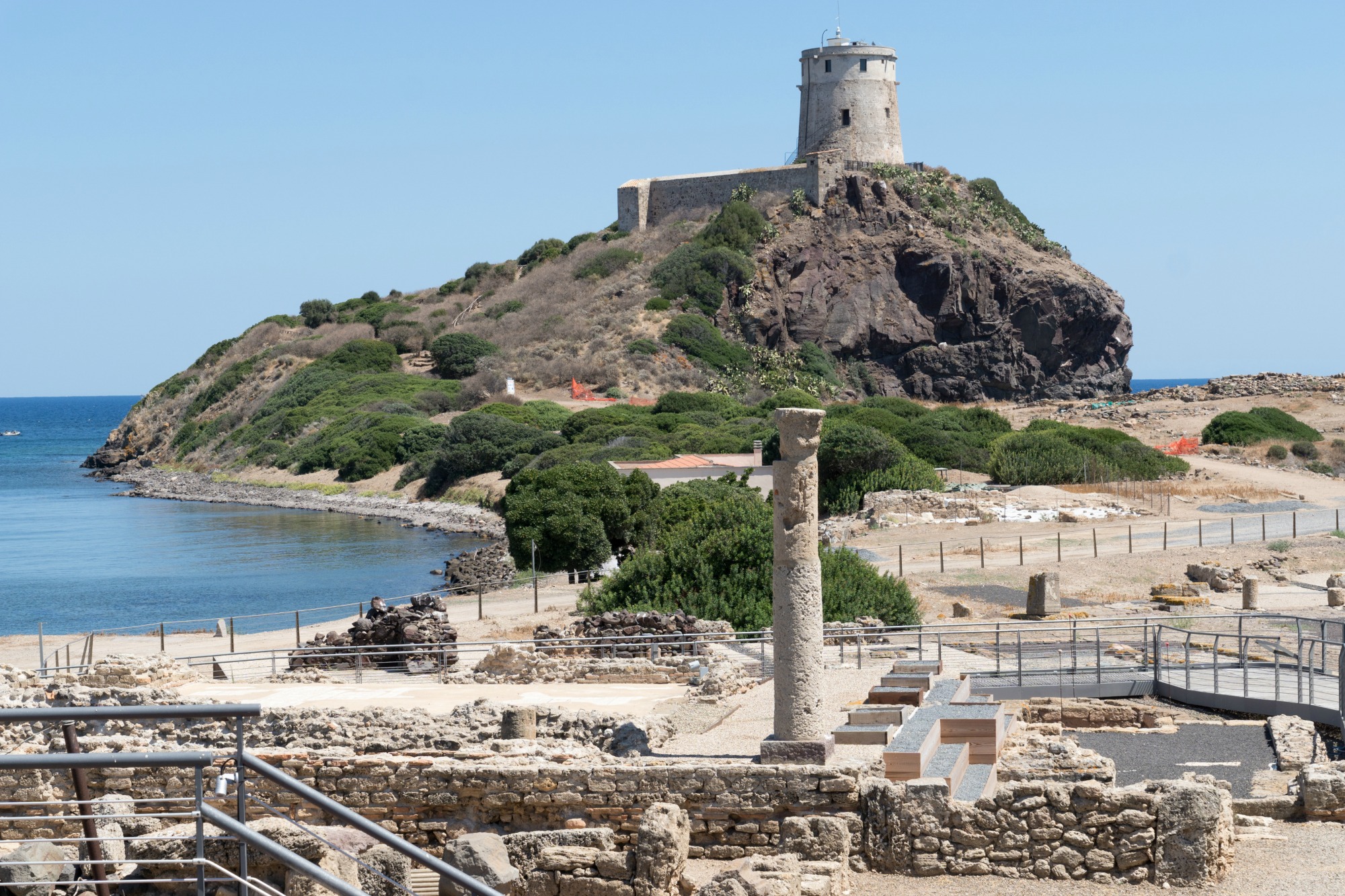
Ancient city of Nora
It was the first Phoenician city in Sardinia (8th century BC), an important commercial crosswords and port of enviable location, in the isthmus of Capo Pula, from which it was possible to set sail in any weather. Nora, which developed fully in the 4th century BC under Punic rule, was conquered by the Romans in 238 BC and became a municipium in the 1st century AC. During the two following centuries, it lived its maximum splendour: urban growth and eight thousand inhabitants, in addition to being caput viae, the starting point of all of the roads on the islands. Of this flourishing city, fascinating remains can be seen at the archaeological park of Pula, a handful of minutes from the tourist centre, and findings exhibited at Patroni Museum. Go snorkelling and admire Roman roads and remains in the bottom of the isthmus, at Punta del Coltellazzo, dominated by a 16th-century tower.
Almost all evidence of Phoenician-Punic times were covered by Roman edifications. Excavations began in 1889, when a coastal storm revealed a Phoenician-Punic cemetery (tophet), bringing to light the remains of the Temple of Tanit, a Carthaginian goddess, and the Nora Stone, in the Museo Archeologico di Cagliari (National Archaeological Museum). On the stele, the most ancient document of the Western world, the name Shrdn, Sardinia, appears for the first time. The tophet sits near the Romanesque little church, the place of martyrdom of the warrior saint remembered every year during Sagra di Sant’Efisio, of whom the Pula population is particularly devout.
At the entrance to the park, you will find remains of the thermal baths that made Nora famous. Take the cobbled streets to enter the heart of the ancient city: Piazza del Foro. Nearby there is a temple with a six-column entrance hall (pronao), while to the north you will find the necropolis and the aqueduct. On the coast, you will come across a nobleman’s house, the house of tetrastyle atrium from the 3rd century AC, with a four-column portico and rooms lined with mosaics (do not miss “Nereid on a marine centaur”). Keep walking and you will see its main attraction, the amphitheatre: originally lined with marble, it had twenty terraces and could seat one thousand people. Today it hosts the La Notte dei Poeti festival. To the south, Aesculapius’s sanctuary, with a mosaic-lined terraced from the 4th century: perhaps the set of the incubation rituals, to ask the gods for remedies. It is the last greatest building: Nora began to decline in the 5th century.
After the archaeological excursion, go for a walk on the beach with golden sand and crystal-clear water, or along the lagoon, with its rare birds. In the evening, try Pula’s nightlife, with events and aperitifs in the piazzas in the centre.