

Su Carroppu
Prehistory in the Sulcis area, and in Sardinia in general, gained a new chapter in 2012. The first traces of the presence of humans have always been attributed to the ancient Neolithic period (approximately the 6th millennium BC), while, in reality, a finding in the site of Su Carroppu on the limestone hills of Sirri, an agricultural ad pastoral district of Carbonia, moves the date to three thousand years earlier. The period in which humans frequented the shelter under the rocks in this part of the Sulcis area dates back to the Mesolithic era: bones were found here and radiocarbon dating places them at 9000 BC, representing scientific proof, after endless unconfirmed suppositions, of the new dating of prehistoric Sardinia.
The shelter of Su Carroppu was first used sporadically by man and it was later populated assiduously in the Ancient Neolithic period (6000-5300 BC). The settlement was also used as a burial place. A civilization developed and was exclusive to Sulcis, hence taking the name of Su Carroppu Culture. Thanks to the excavations in the little and quite shallow (approximately ten metres) cave, numerous pottery fragments were found, the oldest of which from prehistoric Sardinia, made of course, greyish-black material, mostly very thick with brown surfaces with blackish spots. These are fragments of pots, bowls and bulging-shaped dishes, all with convex sides and small looped handles. They have decorations obtained by exerting slanting or vertical pressure on the raw material: an incredible variety of ornamental patterns, with horizontal or slanting stripes, bands of broken lines, internally dotted triangles and other backgrounds that tend to cover the entire surface of the pots.
There is also an abundance of obsidian artefacts, possibly from the nearby Monte Arci - where Sardinia's best preserved ruins of a Phoenician-Punic colony are located – including various shapes and sizes, known as ‘geometric microliths’, small elements that are triangular, trapezoid or circular-segment shaped with a sharp side. Furthermore, the first signs of agricultural activities were also found here. The artefacts are partly kept in the archaeological museum of Villa Sulcis in Carbonia and partly in the National Archaeological Museum of Cagliari.
Flumendosa
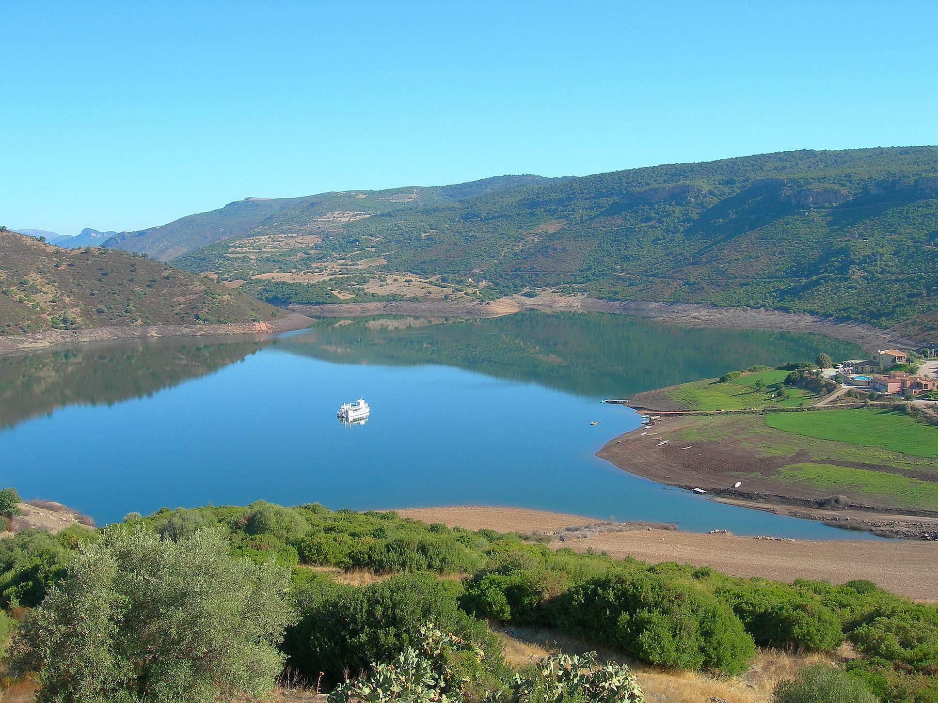
At first sight, from afar, it looks like a shining gem, its sparkling water nestled between mountains that, together with the rocky outcrops, create spectacular contrasts of light and shade. Medio Flumendosa lake is the catch basin of the eponymous river, which flows through the south-central part of Sardinia for 127 km. The river is cut by two dams. The first one is the six kilometre long, 1½ km wide Bau Muggeris gorge at an altitude of 800 metres while the second dam created the spectacular Flumendosa lake, a 17 km long and 500 metre wide basin in the Sarcidano and Barbagia di Seulo area constructed at an altitude of 268 metres in 1952 to generate energy and irrigate the fields of the Campidano region.
The deep blue lake is a wonderful place to go boating and you’ll enjoy the truly memorable experience of floating over it in a Mississippi-style paddle boat complete with upper deck to take in the scenery. The lake is also a great place to enjoy romantic (and family) outings canoeing, sports fishing and wakeboarding. The embarkation point is by the little green Trenino Verde train stop which, along with the paddle boat, are the only way to explore this delightful wilderness area of Sardinia.
In this ‘lake district’ – Flumendosa and Mulargia, linked by a tunnel, and Is Barrocus – nature presents herself to us with breathtaking and unexpected views of landscapes in which to go hiking, visit archaeological sites and enjoy fine food and wine. Start out from the lakes, cross over mountains and hilltops, forests and waterfalls, caves and canyons all the way to the steep cliff walls of Isili, famous for its rock climbing. As the scenery changes, the activities multiply. You will come across amazing natural monuments like the one-of-a-kind su Stampu de su Turrunu – a karstic phenomenon featuring a water that flows through a sink hole to then resurge into a cave as a lake – and the waterfall and caves of Sadali. There are also a variety of not-to-be-missed archaeological sites: the menhir-statues of Goni and Nurallao and the nuraghe architecture of Is Paras (Isili) and Nuraghe Arrubiu (Orroli). Each place is an expression of its own ancient traditions, reflected in the local specialities it offers: bread and cheese, olive oil and wine, flavourful meats and tasty desserts.

San Sebastiano
The church of San Sebastiano sits on an island in the middle of the lake and its reflection in the water creates a lovely panorama of plays of light and colour. The lake is named after the church, which you can reach by swimming to it or in a canoe to see for yourself how many of the ancient legends surrounding it are true.
The Lake of San Sebastiano is in the Isili district and was created by the is Barrocus dam that catches the water of the Mannu river. Along the river’s banks, the lake’s shoreline and all around the surrounding area you can go sports fishing, canoeing, rock climbing and hiking. The route of the little Trenino Verde train runs along the water’s edge and then goes on to Sorgono. The old and now abandoned railroad line that headed towards the Medio Campidano is great for mountain biking and hiking.
San Sebastiano lake is also fed by the rio Corrigas river, along which rise steep cliffs formed some 23 million years ago when much of Sardinia was still under water. Rock climbers come here from all over Europe to climb its sheer rock face, home to more than three hundred climbing routes of various levels of difficulty. All year round, internationally ranked professional free climbers come to the calcareous rock faces found in the is Barroccus area, especially the faces of su Pizzu ‘e Nedda, which rise in a narrow gorge and create beautiful canyons.
The landscape around Isili also includes gently sloping fields of crops, flat plains and fertile countryside. Here you can go on delightful nature walks, horseback riding and cycling, and stumble upon a myriad of prehistoric remains: menhirs megalithic tombs, domus de Janas chambre and 48 nuraghes, most importantly Is Paras, Atzinnara and Nuraxi Longu. There are also traces of Roman and Punic settlements, like the two arches of a bridge over the Brabaciera river constructed in the II and III century CE. The town’s historic centre is also not-to-be-missed, home to churches containing priceless art and the museo per l’Arte del Rame e del Tessuto (Copper and Textile museum), the only one of its kind in Sardinia. One of the town’s most important events is the Bistiris e Prendas, when 400 men and women clad in traditional dress from all over the island gather in a procession.

Sa Chida Santa: authenticity, passion and mystery
Centuries-old ceremonial rites rooted in the Middle Ages and tinged with Spanish tradition come together in archaic Campidanian, Logudorenian and Barbagian traditions that date back to Nuragic paganism. During Holy week, from the coast to hinterland villages you will discover Sardinia’s most authentic essence and experience an itinerary of sacred rituals that revolve around the Passion of Christ. Holy Week in Alghero reveals its Spanish roots. It all starts on the Friday before Palm Sunday with the Addolorata Procession and ends at Easter with the Encontre. The Disclavament (deposition) is deeply emotional: the body of Christ is carried in procession on His deathbed and as the sun sets, the town is illuminated by glow of torches and lanterns draped in red veils.
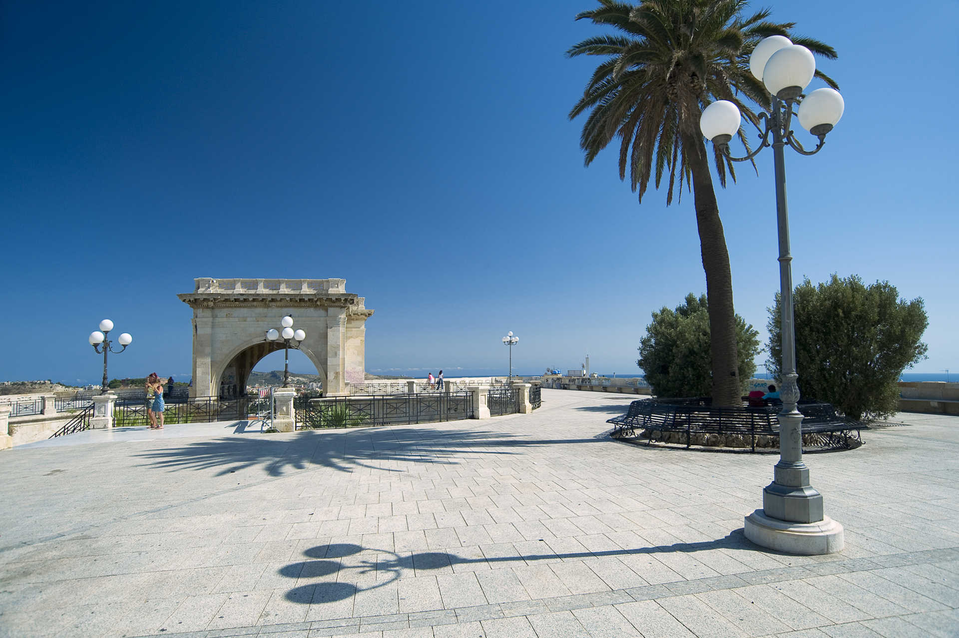
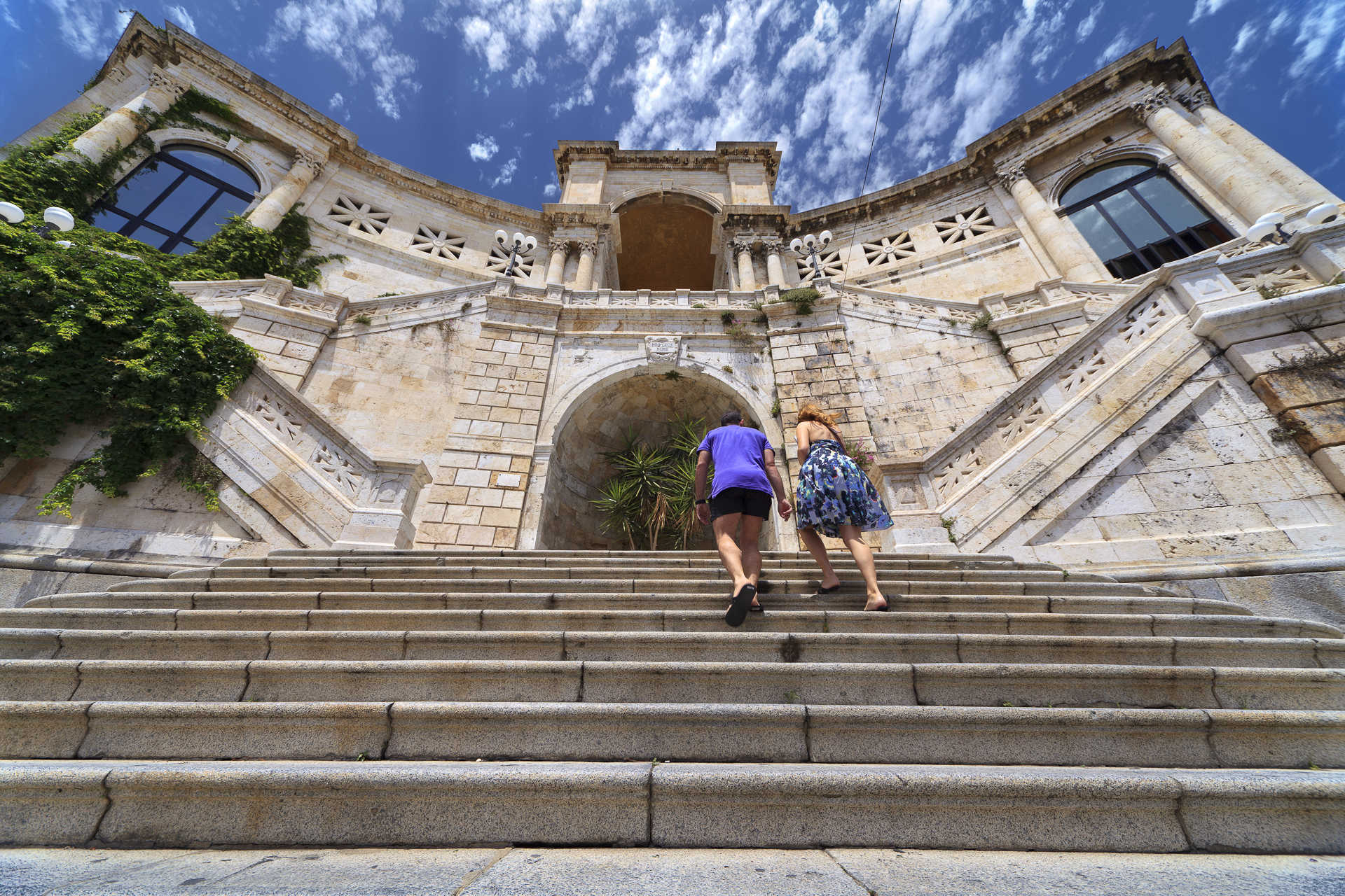
The city hall - Cagliari
Cagliari’s Palazzo Civico, or City Hall, rises above the harbour like a bastion of white stone, elegant in shape and colours, perfectly in tune with the other old buildings that line Via Roma. City Hall was originally located at Piazza Palazzo in the Castello quarter, fortified higher part of the city and symbol of its defence. Thanks a the far-sighted initiative of Mayor Ottone Bacaredda, the city’s main institution was moved to the more popular Marina quarter adjacent to the Stampace quarter by the seashore, a sign of changing times. In 1896 the city’s councilmen had deliberated that the seat of government should leave the city walls and head down towards the harbour. The building’s design was based on a Gothic-Catalan model and constructed with white calcareous rock graced with art deco embellishments. It was solemnly inaugurated in 1907. The move was an expression of a new political trend that reflected the ideas of the business class: visibility, comparison and openness, a radical departure from aristocratic pride and diffidence. Cagliari presented itself to the world as a modern city with an impressive ‘visiting card’: a new City Hall that was not spared the bombing raids of WWII and thus rebuilt between 1946 and 1953.
The building can be visited like a museum and occupies a city block set between Via Roma, where the main entrance is, Via Crispi, Angiogi and Largo Carlo Felice. The façade is graced by a portico of seven arches plus the central arch, which leads to the courtyard. At the top are two 38-metre high octagonal towers, while four obelisks decorated with the heads of the Four Moors adorn the corners. Works in bronze by Andrea Valli grace the prospects: an eagle holding up the city’s emblem, two lions and allegorical representations of Agriculture, Commerce and Industry. A two ramps of stairs lead to the upper floor. In the Consiglio hall are three important works by artist Filippo Figari. The nearby Giunta hall is home to the Gonfalone and the XVI-century retable of the Consiglieri. In the Wedding Hall is a work by Figari depicting a Sardinian wedding, as well as a variety of beautifully crafted artisanal furniture. There are also jewels, archaeological relics and the simulacrum of St. Agostino. In the mayor’s room is a large 1620 Flemish tapestry, and in the Savoy room three works by Maghinotti: portraits of Vittorio Emanuele II, of Carlo Alberto and his arrival in Cagliari in 1840.
Botanical garden - Cagliari
A large green space in the historic centre of Cagliari is home to thousands of plant species from all over the world, some of them very rare, and at its core is an archaeological area that houses a large number of Roman remains. The Botanical Gardens are shaped like a trapezoid and cover an area of about five hectares at the lower end of the Palabenda valley, in an area that includes the Anfiteatro romano, Orto dei cappuccini vegetable garden and villa di Tigellio, where there are other Roman domus remains and what was once a thermal baths. The idea of creating a botanical garden in the valley came about in 1820. It had once belonged to the Jesuits, then to the ruling family, to a series of private individuals and was then purchased by the university. Work on the project began in 1864 under the guidance of the founder Patrizio Gennari, who modified the original project designed by the architect Gaetano Cima.
His touch can be seen at the far end of the valley, which is graced with a series of symmetrical lawns on either side of a main path that leads from the entrance to the fountain of the central square and then on to a pool with a majestic ‘marsh cypress’ and Fontana Pampanini. It is here that you’ll see the oldest of the garden’s plants. On the left hand side of the main path are desert succulents separated into plants from Africa and neotropical flora, and the arecaceae (palms) of the palm tree stand, where an oasis habitat has been created. To the right is a Mediterranean woods, with bushes and trees typical to the Mediterranean wilderness, and an herb garden that is home to commonly used medicinal plants that even science considers the most efficient in terms of herbal cures. A new section devoted to geophytes was very recently (2009) added and boasts some 200 species. A stairway leads from the lowermost part of the garden back up. The Gennari Grotto, the clover pool, the Roman cave, the raised walkway, the germplasm bank and the botanical museum are all also well worth a visit. And you must stop in at the Roccaglie biodiversity area, a display set up in 2004 that recreates the conditions under which a variety of plants grow in a rocky terrain in nature. Some 90% of the endemic, rare and threatened species from western Mediterranean islands, particularly Sardinia, are preserved here. Each section is divided into thematic subdivisions.

Saint Ephysius, the festival of Sardinia
The rustling and increasing sound of footsteps, the rhythm of hooves and carriage wheels that advance in unison. Cagliari is crossed once again by a procession of 2500 people in traditional dress, coming from all over Sardinia, followed by 270 horsemen - those of Campidano, the Militiamen and the Guardiania. A combination of colours, costumes, the sound of the launeddas and the is goccius devotional songs: from 1 to 4 May, we celebrate the Festival of Saint Ephysius. The early 4th-century events linked to the warrior saint are re-enacted and the perpetual vow addressed to him during the plague of 1652 is renewed. An entire island stops to repeat a ritual that has lasted almost four centuries.
Sardinia unveils its architectural treasures
Artistic magnificence, shared memory, identity and a sense of community: this is the most encompassing effort to safeguard, enhance and promote the cultural heritage of Sardinia. Following in last year's footsteps, the 2025 edition — the 29th — will once again take place in two phases, stretching across nine weekends: from May 3 to June 1 for the first phase, and then again between October and November. Hundreds of cultural sites will open their doors during this time, such as museums, archaeological sites, churches and historical buildings, natural monuments and parks. Each town will tell its tale through literary itineraries, architecture routes in cities that have been marked by centuries of powerful rulers. Students and volunteers are warming up to lead you along a travel through the beauty that crosses millennia, all the way to the farthest past. Places of yesterday and today, where memories of the past and ideas aiming towards the future coexist.
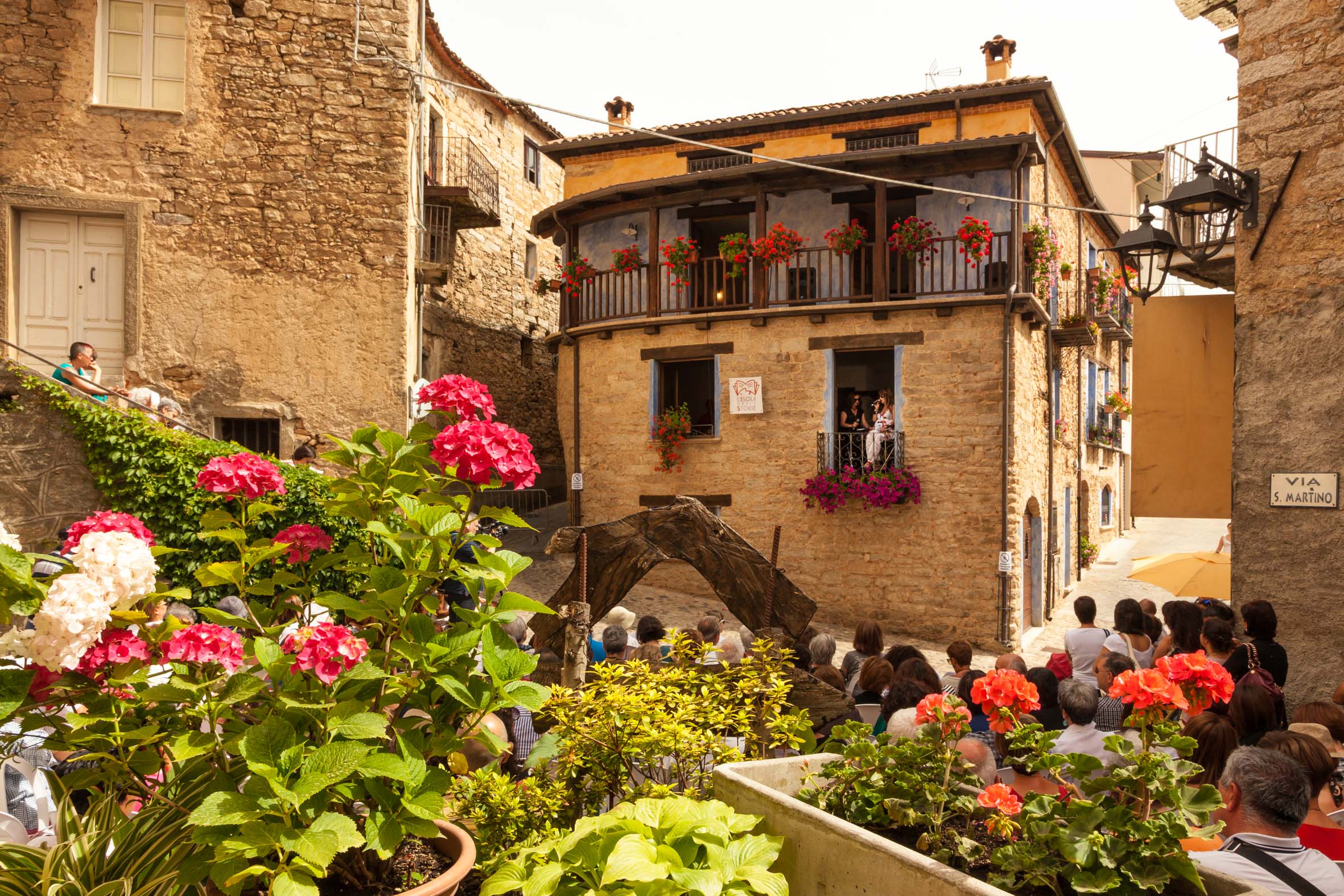
Spring in the villages
The explosion of spring colours on the island are in harmony with one of its most typical ‘picture postcard’ views: the colourful houses of Bosa. Walking along the Temo River, you can admire their reflections in the water, climb the hill dominated by the Malaspina Castle and, by crossing the Ponte Vecchio bridge, you will reach the south bank and discover the ancient tanneries. You will be welcomed by a glass of malvasia wine and impressed with coral jewellery, asphodel baskets and precious textiles. Bosa is a concentrate of history and craftsmanship, industrial archaeology and special treats. Do not miss the churches: the ‘cathedral’ of the Immacolata Concezione, Nostra Signora de sos Regnos Altos inside the castle, and san Pietro extra muros, at the centre of Bosa vetus. And then there is the natural beauty: the park of capo Marrargiu , the reserve of Badde Aggiosu and, on the coast, Bosa Marina, s’Abba Druche and Compoltitu.
Monastir
The name apparently comes from muristenes, an ancient dwellings for worshipers and traders, or from the Catalan word for monastery. It is not by chance that since the end of the 20th century, near the parish church of San Pietro Apostolo, there was a building known as domu de is paras, 'house of the friars'. Monastir is located on the fertile Campidano plain, between two little hills of volcanic origin, Mounts Zara and Olladiri, which break up the flat trend of the countryside through which the Riu Mannu and Riu Flumineddu rivers flow. This municipality has four thousand 500 inhabitants and is situated twenty kilometres from Cagliari. It has an agricultural vocation: citrus fruits, peaches and potatoes are grown all over its territory.
The present-day village emerged in the Middle Ages around a community of Camaldolese monks. It was part of the Calari Giudicato and, for a short period, that of Arborea, after which it became the property of Pisa. The remains of the Baratuli Castle are an emblem of that period and stand on top of Mount Olladiri. The castle was built in the middle of the 12th century by the Giudici (rulers) of Cagliari, after which it passed to those of Arborea and was destroyed by the Pisans at the beginning of the 14th century. The old town centre extends around the parish church of San Pietro, the patron saint of the village and its Gothic-Aragonese structure dates back to the beginning of the 16th century. The church of Santa Lucia is much older (second half of the 13th century) and it is a Romanesque style church. At the end of August, the celebration in honour of the saint takes place: this is the moment felt most deeply by the community of Monastir, with processions to and from the parish church and the little rural church, accompanied by worshippers, knights, wagons pulled by oxen, groups in costume and launeddas players. The first celebration of the year is that of the Fires of Sant'Antonio Abate (17 January) to whom a 14th century Gothic church is dedicated. Next, a few days later, there is Su Foghidoni for St Sebastian. A 15th century sanctuary is named after him. In this extremely devout village, other religious buildings stand out: the church of San Giacomo, which is the most ancient (12th century) and is embellished with a spiked bell-tower, and the church of the Beata Vergine Maria (or of the 'Madonnina').
Monastir boasts a remarkable archaeological heritage. The oldest evidence is in the hills: in Is Aruttas, a Domus de Janas necropolis (3200-2800 BC), on Olladiri there are the remains of Pre-Nuragic and Nuragic huts, on the Zara there are the Domus de Janas known as Is Ogus de Monti and the monumental flight of 60 steps dug out of the rock, which lead to the acropolis. At the top of the hill, you will see the sacred Nuragic area, two altars and two wells used for worship of the water deities. At the bottom of the steps, there is a 9th century BC circular building, used for various activities, including wine-making. In the area, there are is also the Su Cuccumeu Nuraghe and the village of Mitza Morta.