
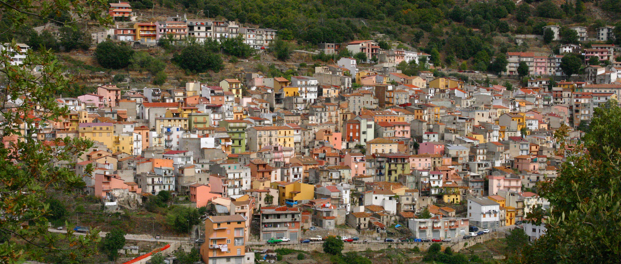
Seui
A charming medieval village located at an altitude of 800 metres on the southern slopes of the Gennargentu massif. Around Seui, a village with one thousand 300 inhabitants, you can admire a varied landscape of colours that change according to the season. An enchanted world to travel through along trekking trails or on board the Trenino Verde tourist railway. The setting is made even more precious by the Montarbu forest: 2800 hectares between vertical rock faces and valleys furrowed by streams and waterfalls, like Serra Middai. It is a wildlife oasis, inhabited by the golden eagle, the deer, the fallow deer and the mouflon. During the climb up to Punta Margiani Pubusa (1325 metres), you can admire the sinkhole of Su Stampu and you will reach the monument of Perda Liana. Holm oaks cover half of the 15 thousand hectares of Seui territory, where there is an abundance of downy oaks, cork oaks and conifers on the peaks. An unusual feature is the forest of European hop-hornbeam and yew of Mount Tonneri. Chestnut trees, which take on a warm colour in the autumn, frame the village. There is prehistoric evidence set between cliffs and forests: the Nuraghe Ardasai stands out at an altitude of one thousand metres, with its central tower surrounded by walls, against which there are other towers. Around it, there are the remains of huts.
Seui is a 'village-museum', starting from the Palazzina Liberty (Art Nouveau building), a stately building that became an exhibition of art and popular traditions and reminders of mining activities are also kept here: the disused complex of Fundu e' Corongiu exploited the only deposits of anthracite on the Island and was active for over a century (1850-1960). The itinerary winds amidst the houses made from schist rock with arches, wrought iron balconies and tiled roofs that follow the direction of the little alleys as they twist their way through the village centre. From the building-museum you will pass by the Spanish jail, which was active from the middle of the 17th century until 1975: lodgings for the guards, a kitchen and three cells were the tools of justice (and of torture) for three centuries. Travelling along Via Roma, you will reach the Farci house-museum, where the writer and politician Filiberto Farci lived and who was a friend of Emilio Lussu and co-founder of the Sardinian Action Party. The last stop is at the civic gallery, inside S'Omu Comunali, the impressive civic building dating back to the end of the 19th century, full of works of art, among which valuable paintings by artists of the Caravaggio school. Little lanes and stone houses gravitate around the parish church of Santa Maria Maddalena, in which there is a marble baptismal font with friezes (1644) and an 'unusual' multi-coloured wooden statue of the saint. Inside the eighteenth-century church of San Giovanni Battista, there is the float on which the Madonna del Carmelo (Our Lady of Carmel) is transported in a procession during the most heartfelt festivity, at the end of July. At the end of June, in honour of the saint, there is Su Cardamponi (community lunch). Su Prugadoriu, the 'Sardinian Halloween' is famous, during the commemoration of the deceased. During the festivities you will be able to enjoy agricultural and pastoral traditional delicacies: culurgionis, civargèddus, chickpeas, lardo (a cold cut) and potatoes, pecora in capotto (a sheep meat speciality), còrda and peas, roast meats and cheeses.
The Marinedda
Its spectacular sand dunes are set between the cliffs of Isola Rossa and Punta Li Canneddi. The wonderful and extensive beach of Marinedda will strike you, with the contrast between its crystal clear waters, its light sand and the red granite of the towering cliffs with their various shapes. It is part of the same coastal stretch as the beach of Longa, which is part of the picturesque fishing village of Isola Rossa, in the territory of Trinità d’Agultu e Vignola.
The beach has light, white sand and slopes gently into the shallow waters, suitable for children to bathe and play in, while behind it there are dunes covered by Mediterranean vegetation. It is a famous beach for windsurfing enthusiasts and every year, in August, it hosts international speciality competitions. Part of it is equipped with deckchairs and beach umbrellas and it offers various services for water sports, as well as a sailing school. It can be accessed by the disabled, has ample parking, a campsite, hotels, bars and restaurants.
It is joined to the beautiful beach of Isola Rossa and it is near the little beach of Li Femini, which is next to the little harbour. Ten kilometres away, you will find Li Feruli (or Li Mindi), also in the territory of Isola Rossa, and the romantic bay of Li Tinnari, beach of the Costa Paradiso, hidden away between the granite rocks and formed by little red and grey trachyte stones, which you can reach on foot or via the sea.
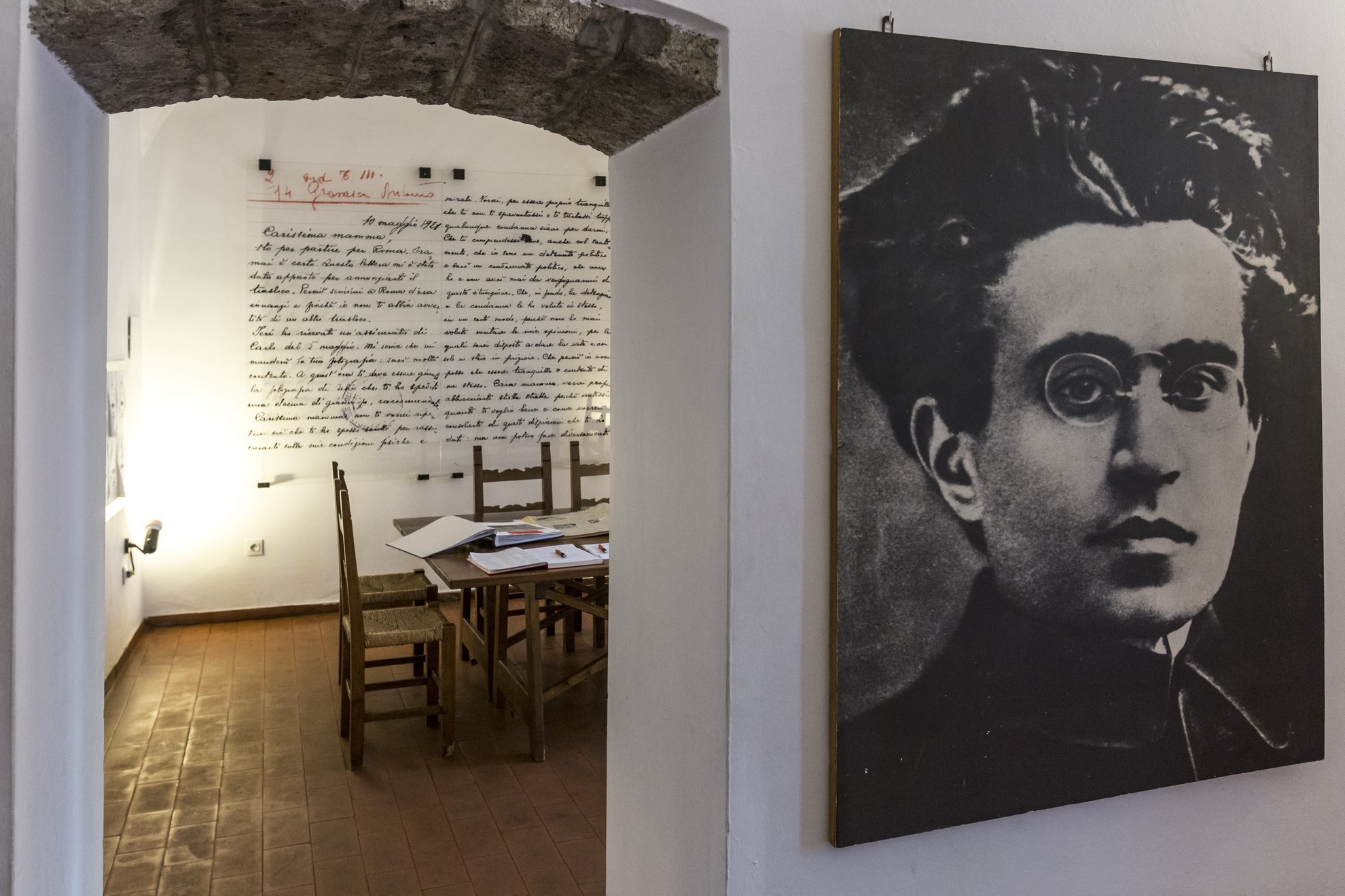
Casa Gramsci
Antonio Gramsci lived in the old town centre of Ghilarza, between 1898 and 1914, and was the creator and founder of the Italian Communist Party, as well as one of the most influential twentieth century European intellectuals. His modest dwelling brings to mind the image of a family that, in a situation of financial difficulty, transmitted to him the values on which his work was later established. He spent his childhood and adolescence here, educated by his cultured and sensitive mother. He attended primary school in Ghilarza, junior school in Santu Lussurgiu and secondary school in Cagliari, where he started participating in 'battles' for the establishment of free thought. His cultural interests, reading and inclination towards science and mathematics made him stand out. He started to write, after being noticed by the director of the Unione Sarda newspaper. He concluded his studies brilliantly and moved to Turin but his interest in his homeland remained alive in his mind.
In 1965, the Italian Communist Party bought his house in Ghilarza, making it a centre of documentation and research. In order to transform it into a museum, fundamental work was carried out by his nieces and by intellectuals, among whom Vando Aldovrandi. The promotion of events celebrating Gramsci are also their merit: on 27 April, Ghilarza becomes a meeting place and one in which homage is paid to an ideologist who has been translated all over the world. The house is the headquarters of the association that manages the museum. At the end of 2016, the Fondazione Casa Gramsci was created.
The journey through the museum, with images, documents, personal effects and statements will allow you to relive the significant stages of his life: study and thinking, journalistic and political activities, imprisonment and illness. It is organized into six rooms, spread over two floors. In the first room, there is an enlarged reproduction of the letter he wrote to his mother, in which he talks about doing his time in prison for not having changed his opinions. Following on, there is the former kitchen, now a place for meetings and study. A third room contains the library: three thousand books on the history of the labour movement and Gramsci's thinking and work. From the entrance, a staircase will take you to the upper floor, where a bedroom from that period has been reconstructed. In a tape library, there are statements made by forty historical and influential personalities who knew him. On a wall, there is a reproduction of the prison cell in Turi, where he was locked up.
Cala Sinzias
A small cove that opens its beauties beyond a thick eucalypt grove, protected by a promontory that offers a spectacular view of the turquoise horizon. The Cala Sinzias beach, 15 kilometres from Villasimius and 7 from Costa Rei, is part of the territory of Castiadas. The cove is a 2-km strip of fine, soft sand, deep and very white, incredibly clear seabed that drops quickly, and crystalline waters with various blue hues, marked by Goletta Verde of Legambiente as one of the cleanest in Sardinia. The beach is dotted with a few rocks, providing the landscape with a variety typical of the eastern coast. Behind it, thick vegetation: junipers, mastics, olive trees, pine trees and eucalypts.
If you love road trips, Cala Sinzias is perfect for you: a parking space equipped for campers and two famous camping sites right in front of the beach. The very wide beach makes it possible to relax in absolute tranquillity and to walk along the shoreline or swim in the deep water, with all services available: parking, beach equipment for rent, bars and restaurants. The beach is accessible to disabled persons, and its sea is so rich that it is a beloved destination of experienced and amateur scuba divers. Beaten by the wind, it is also a popular surfing destination. All 13 kilometres of the Castiadas coast immersed in green are some of the island’s most beautiful areas, with a succession of white-sanded and bright-coloured landscapes. The southern tip of Cala Sinzias is the Cappuccino rock. There begins a little piece of paradise: the Cala Pira beach, with soft sandy dunes and intense Mediterranean scents. To the north, there is Punta San Pietro, with another wide and marvellous beach. Beyond begins the very long coast of Costa Rei, ten kilometres of fine, golden sand that gradually dive into a sea that is the colour of the sky. The territory of Castiadas includes the beaches of Monte Turno, Sant’Elmo, and Santa Giusta, all the way to the Scoglio di Peppino, coastal boundary with Muravera.
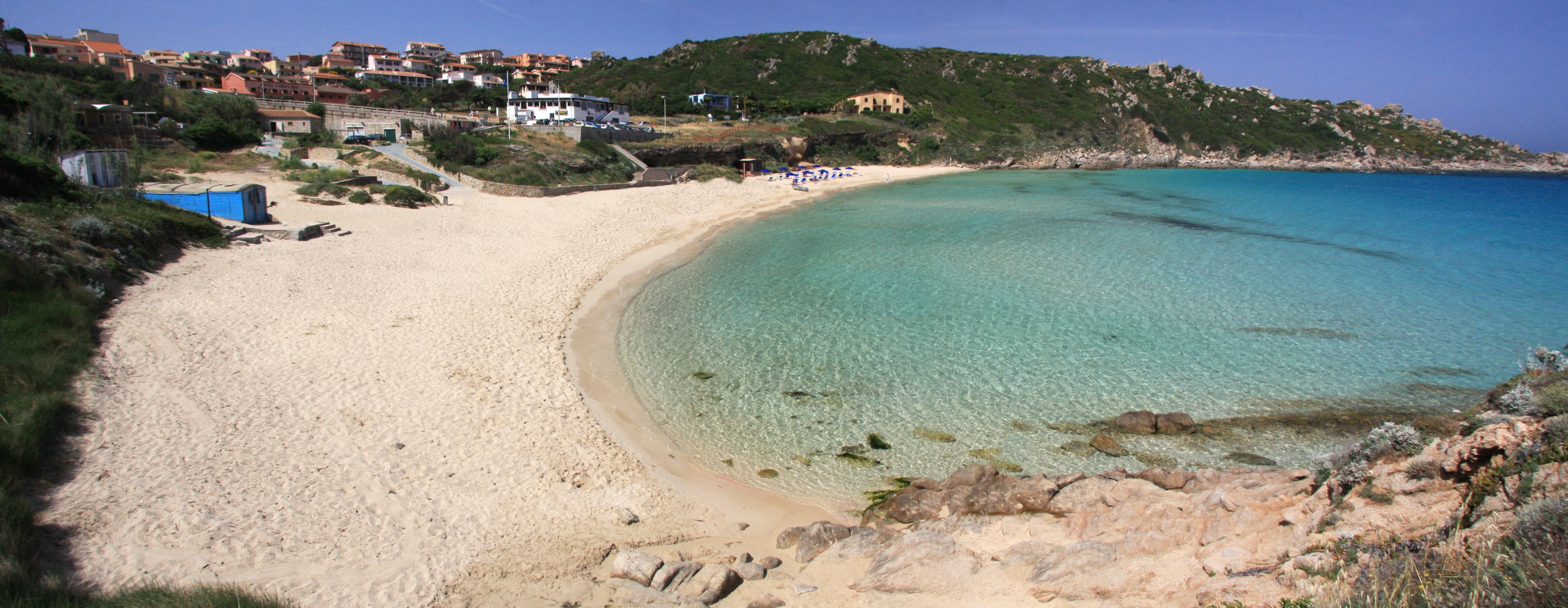
Rena Bianca
A paradise with bright colours and clear waters only a short walk from the town centre. The Rena Bianca is the city beach of Santa Teresa Gallura, a cove 700 metres long, with shallow waters and thin, soft, white (as its name states) sand that has pink reflections on the shoreline, thanks to minuscule coral fragments. You can see it from the top of a hill where the main piazza of this seaside town opens up, and you will be excited to get down there, at the bottom of a 300-m descent and a set of stairs, which you will climb down all at once.
The beach is framed by cliffs and perfumed by the Mediterranean scrub. The Municca peninsula and the Municchedda islet protect it from the western wind, while the promontory where the 16th-century Torre di Longonsardo stands protects it from the eastern wind. The fresh, silver waters awe visitors with their thousand hues from blue to turquoise and green, and are always incredibly clear. The Rena Bianca has been awarded the Blue Flag by the Foundation for Environmental Education due to the quality of its waters, immaculate coasts and services that provide tourists with comfort and safety. Beloved by divers and children, the beach is accessible to disabled people and is rich with services, wide parking area and restaurants. Beach resources rent beach equipment, sunbathing chairs and underwater exploration.
There are other gems to be explored in the Santa Teresa territory: to the east of the town, in the northernmost tip of the island, there are picturesque Cala Sanbuco, beautiful Cala Balcaccia and La Marmorata, wide and well equipped. Towards Palau, the natural granitic pools of Valle dell’Erica, the very long Porto Liscia-Sciumara, home of windsurf, and the enchanting peace of Conca Verde. To the west, there is Capo Testa, a peninsula-promontory connected to the mainland by a strip of sand that creates two beaches, Rena di Ponente (or Taltana) and Rena di Levante. In the same promontory, enjoy the spectacular Valle della Luna and Cala Grande. Near the rocky coves of Santa Reparata and, along the coastal road to Castelsardo, lovely Lu Pultiddolu, from which you can get to the dune of Rena Majore, in the Aglientu territory.

Olbia
The ancient Greeks called it olbìa, ‘happiness’. It is the gateway to the island and the driving force behind the economy of the Gallura area. Vestiges of the past dot the city. Many of the relics archaeologists have brought to light, like the 900 gold coins, are now safeguarded at the Archaeological Museum on the islet of Peddone. The Punic-Roman, and later Christian, necropolis includes 450 tombs and comprises the museo della necropoli, located at the feet of the altar of the beautiful Basilica di San Simplicio. Built between the late XI and early XII centuries, it is this region’s most important church, as well as being the oldest vestige of Christian presence on the island. The patron saint is celebrated in mid-May with the heartfelt Festa di San Simplicio, when the faithful, in costume, take part in a procession. The celebrations include the palio della Stella joust. You will also be struck by the Baroque architecture of the Church of San Pablo, with its brilliant ceramic dome. Traces of man’s presence here date to 4000-3500 BCE in the form of dolems, menhirs and circular mageliths. Some 50 Nuragic settlements date to the Bronze Age, including the Tomb of the Giant of su Monte de s’Aba, the riu Mulinu nuraghe, the village of Belveghile and the sa Testa sacred well. The Phoenicians came here in the VII century BCE, followed by the Greeks. The first stable settlement was Punic (V-IV century BCE). The Carthaginians surrounded the settlement with walls and towers, remains of which you can still see on Via Torino. The town became the east coast’s largest city when the Romans took over. Under them, Olbia got paved roads, thermal baths, and a forum, traces of which remain near the palazzo comunale, as well as an aqueduct in Tilibbas (I-II century CE). Then there are the remains of the s’Imbalconadu villa (1st century CE). In 1999 twenty-four shipwrecks came to light, some of which had been sunk by the marauding Vandals.
The city looks out over a spectacular gulf that encompasses the Tavolara Marina Area. It is the access point to the exclusive Emerald Coast. The seemingly endless Olbian coastline is home to a myriad of turquoise inlets from which to choose, among them are the four beautiful bays of Porto Istana, within the confines of the protected area, the Lido di Pittulongu, especially La Playa, a local favourite. Next to it, one after the other, are the beaches of Squalo, Pelicano and, further north, Mare, Rocce and Bados, which borders on the Golfo Aranci. Another long stretch of shoreline follows, offering visitors sandy or pebbly white beaches and crystalline water at Porto Rotondo, Marina di Cugnana and Portisco, in particular, sa Rena Bianca. Southwards, headed towards San Teodoro, are the yellow-ochre sandy shores of Lido del Sole, Le Saline, Bunthe, Li Cuncheddi and Punta Corallina. To this fascinating array of sea and archaeology add fine food in the form of Olbian clams, to be paired, of course, with a glass of vermentino.

Laerru
Laerru arises in the heart of the Anglona historical region, on the slope of a hill detached from the southern edge of the Tanca Manna plateau. Laerru is a village of less than 1,000 inhabitants in the province of Sassari, having very ancient origins. The name perhaps derives from the Latin alaternus, an evergreen shrub typical of the area. It was once called Laerro, which belonged to the Giudicato of Torres until 1272, before then passing to the influence of the Doria family. After the Catalan-Aragonese conquest, the fortunes of the town were connected to the Oliva family until 1843. A number of 19th-century buildings have been preserved within its historic appearance. The most important building is the parish church of Santa Margherita, constructed in the 16th century in late-Gothic style and later modified. To be admired today are the two Gothic-Aragonese chapels. The patron saint is celebrated in July. Another monument is the oratory of the Rosary, built in the 17th century in Baroque style. The economy is mainly agricultural-pastoral, with the cultivation of grains, fruit trees and vines together with sheep and cattle breeding. During the feast of San Giovanni, at the end of June, there is a banquet based on boiled sheep. Local handicrafts are renowned. What distinguishes this town is the ‘radica sarda’ (root) with which pipes of great value are produced, famous all over the world.
The territory is characterised by the alternation of rugged hills and verdant plains. The Tanca Manna plateau is rich in springs and caves, such as the Conca ‘e Caddu and su Coloru, one of the largest Sardinian karst caves. Particularly striking is the petrified forest of Monte Ultana, a veritable pre- Nuragic and Nuragic archaeological park with various Domus de Janas, a Tomb of Giants, a Nuragic temple, an imposing Nuragic structure surrounded by a village (and also a 4th-century Christian tomb). Another striking site is the Tomba di Bopitos, a megalithic funerary construction attributable to the 3rd millennium BC. The first traces of human settlements in the territory were found, rather, in the Rio Altana, dating back to the Lower Paleolithic. Also of great interest are the dozens of additional Nuraghic structures, some of which are in excellent condition. Not far from the village, in Santa Vittoria, there are the remains of a Castrum and Roman Tombs.

Tortolì
Tortolì is the port of Ogliastra, the gateway to a surprising world with a wide variety of landscapes. Around the city, where 11,000 people live and to which tens of thousands of tourists flock in summer, you’ll find tropical beaches, dense woods and Mediterranean brush, fertile plains and marshes, gently rolling hills covered in tilled fields and an oddity, a wide stripe of porphyry red rock that runs parallel to the coastline. The Rocce Rosse, literally red rocks, in the Arbatax area are the most spectacular example of this phenomenon, a natural monument that sticks straight up out of the emerald blue sea along the shore offering a truly amazing colour contrast. It is here that the Rocce Rosse Blues festival is held. The adjacent harbour is where the tourists arrive and take off on excursions to explore the enchanting coves and inlets of Ogliastra. The sea around Tortolì is magnificent, it is the shoreline that has most often been awarded the FEE’s Blue Flag. Behind the Rocce Rosse is Cala Moresca, the city’s pride and joy, a beach of golden sand edged with granite boulders. A bit further south you’ll find the many shades of blue of Porto Frailis and the long Lido di Orrì beach: sixteen kilometres of hidden coves and little beaches, including the lovely Cala Ginepro, blessed with fine sand, polished pebbles and a stand of juniper trees, and San Gemiliano. The red rocks also appear in the little slice of heaven that is Cea, four kilometres of soft white beaches. This spectacle of nature is complemented by lovely green areas: like the town’s La Sughereta park and Batteria park, perched on the top of a hill with views over the entire gulf.
There are more than 200 monuments here that date back to the Nuragic Age, and the s’Ortali ‘e su Monti is an exemplary site. Its seven hectares includes a Nuragic complex, a Giant’s Tomb, two menhirs, huts, a domu de Janas chamber tomb, a wall and the remains of another nuraghe. The port of Sulci Tirrenica was built to accommodate navigators with the arrival of the Phoenicians (VII century BCE) and the Punic peoples. Traces of Punic settlement were found in the marshes of Tortolì, while vestiges of Roman domination take the form of shipwrecks in the depths of the gulf. The ancient control towers, like the torre di San Miguel, were built by the Spaniards. The city’s landmarks include the su Logu de s’Iscultura museum of modern art and the former Cathedral of Sant’Andrea, a classic building from the XVIII century built over an older church. Two chapels of the older church remain, and in one of them they found the simulacrum of St. Elisabeth of Hungary. Inside the church is an elaborate altar of multi-coloured marble. The town’s most heartfelt festival is Stella Maris in late July at the church of Arbatax and features a procession that leads to the water’s edge.
While in the area, make sure to eat some culurgiones, typical ravioli, the stews, porcetto, roast lamb and boiled sheep meat along with a glass of cannonau, the most authentic of Ogliastra’s experiences.
Villacidro
Once a 'mountain village', famous for the healthy air, now a modern little town that maintains its agricultural and pastoral traditions and produces excellent olive oil, wines, from which a fine liquor is made, and cherries, to which a famous feast is dedicated in June. Villacidro, a large town in the Medio Campidano province with 14 thousand inhabitants, stands where the plain makes way for the spurs of Monte Linas. Its wealth is its natural beauty, including: the valleys of Coxinas and Villascema, lush woods, among which the forest of Montimannu, dolomitic landscapes, meadows of asphodel and hills covered with Mediterranean scrub. The territory is filled with torrents that form spectacular waterfalls. The most famous, a holiday destination of the poet Gabriele D'Annunzio, is sa Spendula, a 'blade' of water that splits the rock between oleanders and holm oaks, making three consecutive drops. Along the trails of the Monte Linas-Oridda plateau-Marganai complex, a park ideal for trekking, tours by bike or on horseback, the show goes on with the waterfalls of the Linas rivulet, Piscina Irgas, that plunges after a drop of 45 metres, and Muru Mannu (in the territory of Gonnosfanadiga), the most impressive on the Island (70 metres high).
Villacidro is firmly anchored to the values of the past, celebrated by the writer Giuseppe Dessì, its most illustrious citizen, to whom the Dessì cultural park is dedicated within Monte Linas: the landscapes are those glorified by the works of the winner of the Strega Prize (1972). On the subject of culture, don’t miss out on a visit to the museum of sacred art, the pharmaceutical museum sa Potecarìa, and the archaeological museum of Villa Leni, once a grain bank. In it, there is evidence of a territory inhabited in the Neolithic period, then in the Copper Age and the Bronze Age (the Nuragic village of Cottega and various nuraghi) and in the Roman period (one necropolis and the ruins of two thermal baths), when the first residential area may have appeared, that of villa citra, the 'villa on this side of the river'. In town and in the countryside, among the religious buildings, two that stand out are the church of San Sisinnio (17th century), set between centuries-old olive trees, and the parish church of Santa Barbara, of sixteenth-century origin. Still remaining from its original Gothic-Catalan layout, there are the bell tower and the capilla mayor (choir) with a stellar vault, not affected by the renovation at the end of the 17th century, giving the church a Neoclassical appearance. During the 18th century it was enriched by prestigious furniture, like the main altar. The public washhouse, which was inaugurated in 1893, is worth visiting: its roof, which is supported by cast iron columns, protects 36 tanks clad with trachyte. The residential centre comes to life with various events, among which the Fuochi di Sant'Antonio Abate in mid-January and the celebration of is Animeddas (or Mortu mortu) at Halloween: Villacidro is traditionally known as the 'village of the witches'.

Cardedu
A tourist village, a few minutes from splendid beaches, that emerged following a tragic event. Cardedu is the youngest Municipality in the Ogliastra region, with less than two thousand inhabitants and overlooking the Ogliastra coast. The original nucleus includes several families from Gairo that, after violent floods in the middle of the 20th century, were forced to abandon their houses in the old village of Gairo Vecchia. Some of them moved to the new Gairo and some to the plain near the sea. In the area where the village lies, there was first a scattered settlement, known as 'la borgata' (the hamlet) and then, in 1966, the homes of the families from Gairo were built around it, giving rise to the real village. Cardedu was a district of Gairo until 1984, the year in which municipal autonomy took place. In the residential area, worthy of note is the parish church of San Paolo Apostolo, inside which there is a Via Crucis, a work resulting from the multifaceted talent of Maria Lai. The municipality was formed recently, but the population has thousands of years of culture, which is deeply-rooted in Gairo Vecchio and is evident in the local skills (cutlery works, basket-weaving and food and wine), in the popular traditions and the religious celebrations.
In its territory, which has been inhabited since prehistoric times, there are various archaeological sites. Dating back to the Neolithic period, there is the Domus de Janas of Monte Arista, the Domus de Janas of Cucuddadas and the Menhirs of Costa Iba. The most evident period in the area is the Nuragic one: four Nuraghi, among which the Perda 'e Pera Nuraghe and the impressive Su Presoneddu sacred well, which is still intact.
The territory has a very varied structure: large plains, gentle hills, mountains, among which the natural oasis of Mount Ferru, as well as stretches of shoreline, with both sand and rocks. The sandy coast is nearly five kilometres long: in Marina di Cardedu you will find the beaches of Foddini, Tramalitza, Museddu and Perd 'e Pera, with a sandy seabed and light, fairly fine sand mixed with little pebbles. The waters are transparent and crystal clear. Then, a one kilometre long rocky, rugged stretch begins, which is reddish in colour, typical of the Ogliastra region, and features low Mediterranean scrub. In the southernmost part of Cardedu, there is Sa Spiaggetta, with smooth, rather large pebbles.