

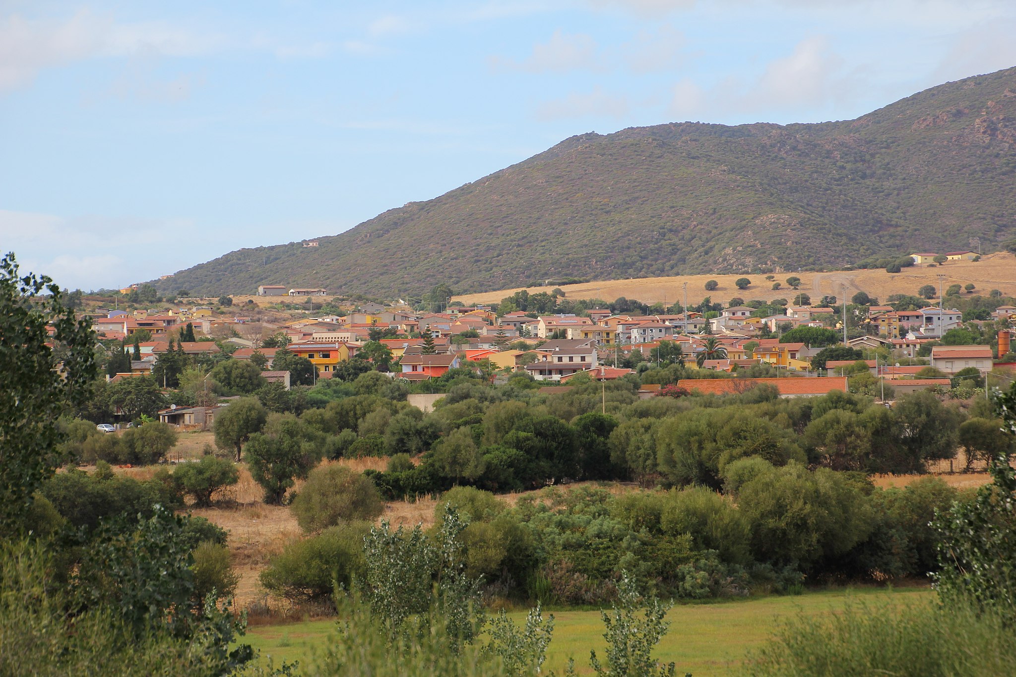
Masainas
Set on a plain nestled among the marshlands alongside the Gulf of Palmas and the south-western edge of Mt Sulcis, cloaked in aromatic Mediterranean vegetation. The modern-day town of Masainas counts 1,300 inhabitants and arose in the late XVIII century, first as a medau (a single farm) and then as a boddeu (a grouping of farmhouses) around the late IX century Gothic-Aragonese church of San Giovanni Battista. The church may have been built over an older, XI century construction when the Benedictines began their proselytization in the area. In the early 1800s, Masainas was a flourishing rural town with 1,800 inhabitants, the largest of its area. Proof of its vocation for farming and shepherding lies in the many furriadroxius, small sheep folds, to be found in the outskirts. In 1975 it became an autonomous town and farming remains the town’s mainstay. The surrounding area is dotted with pastures, vineyards (in particular Carignano grapes) and fields of artichokes. The Artichoke Festival, featuring a variety of local delicacies, is held every year in late March. In early October there is a festival in honour of the patron saint, the Madonna della Salute, one of the most heartfelt in the Sulcis area.
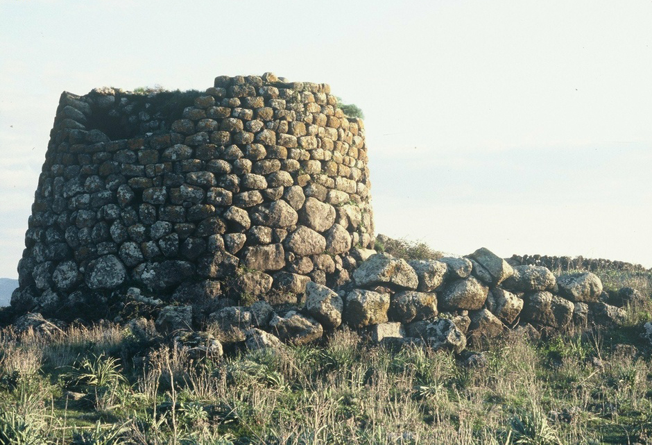
The hills that lead up to the slopes of the mountains change colour and contour according to the season, including the typically Mediterranean vegetation: yellow, red and brown euphorbia (devil’s milk), the deep green of the myrtle bush and lighter shade of the olive trees, the yellow bloom of Spanish Broom in springtime, the grey brown hues of the rockrose. The higher altitudes are home to oak stands, arbutus trees and heather. As you hike up the trails to the summits, you’ll enjoy views of the sea and the Sulcis archipelago. Here eagles, kestrels and buzzards fly. The Sardinian partridge nests here. Not far out of town are the Baiocca and Porto Botte marshes, habitat of herons, black-winged stilts, pink flamingos, cormorants, rare march falcons and swamp hens, all of whom take turns is adding colour to the still waters. High dunes separate the lagoons from the two kilometres of coastland (one with sandy beaches, the other rocky) and are home to a population of wild rabbits, the prey of foxes, hare and the rarer marten and weasels. The stretch of fine white sand scented by juniper bushes and Aleppo pines is where you will find the is Solinas beach. Neolithic settlements were uncovered not far from this sandy shore. Ten nuraghe bear witness to the Bronze Age here, the most interesting being the is Fais nuraghe, four towers laid out like a cross. It eventually came first under Punic rule, followed by the Romans. The remains of a terracotta utensil factory and two Roman sarcophagi were uncovered here. Presumable evidence of a Roman site at is Manigas came in the form of coins, while two tombs hewn into the rock were found at Serra lepuris.
Aidomaggiore
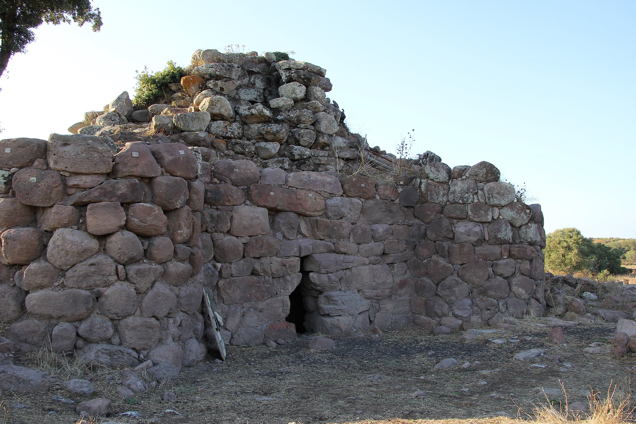
An ancient farming and shepherding village sits at the top of the high plain of Abbasanta, nestled in verdant woods of cork trees, olive groves, vineyards and fruit orchards with a view over one of the greatest artificial lakes in all of Europe, Omodeo lake, today a tourist attraction. Aidomaggiore is the preferred destination of nature and archaeology enthusiasts, of those who want to explore the lake in a canoe and see the sites that dot the territory, like the stone domus de Janas, the giant tombs, the Sanilo and sa Jua nuraghe and the largest, the Tosingalo nuraghe. Nestled in Mediterranean brush it is a single-tower building that stands out for the black basaltic stone with which it was made. The inner chamber has a terrace at a height of eight metres reached by a ramp of stairs.
Speaking of culture, there are also two spectacular country churches. Santa Greca dates to 1797 and is five kilometres out of town on a lovely hill not far from Omodeo Lake. It was on the same spot where an older church had once stood (Santa Giusta), which in turn had been built on the ancient grounds of a Roman camp that had been occupied until the late Imperial Age. The perimeter is dotted with settlements, some prehistoric, and not far away you’ll find other nuraghes (Atos, Mura e Logu, Uras). What is now the Church of Santa Maria delle Grazie (or de Orraccu), dates to the XVII century, but it has far older origins. On 8 September every year they celebrate with traditional dances, music and shows performed by folk groups from all over Sardinia. The celebration ends when the procession brings the statue of Maria Bambina to the Church of Santa Maria delle Palme, in the centre of town. The lovely location of the church offers beautiful views of Omodeo Lake, the Barbagia and Mandrolisai mountains. It was a strategic location, known as sa Bastia. Speaking of festivities and traditions, Aidomaggiore is also famous for its bonfires in celebration of Sant’Antonio, for its Carnival and, above all, for the rituals and festivities surrounding Holy Week.
Nuraghe Appiu
A collapse had concealed its shape and safeguarded its secrets, but after restoration and consolidation works, the Nuraghe Appui finally revealed its - at least in its current state - uniqueness: the courtyard, or rather the space between the central tower (or keep) and bastion, is covered. The only small opening is in the upper reaches, intended to let light filter in and, probably, allow the smoke to exit when the hearths were lit. But who knows whether this fortress harbours further surprises, given that many of its rooms still remain to be studied.
The nuraghe sits in the countryside outside of Villanova Monteleone, facing the sea at the feet of mount Cuccu, at the very top of a plateau known as Chentu Mannas that looks out over the coastline between the protected areas of Capo Marargiu and Capo Caccia. The building is quadrilobed, with rectilinear walls connected to corner towers with carefully crafted ashlars in the shape of an ‘L.’ The main door will lead you to a covered courtyard, from which several openings lead to the keep and side towers. The central tower is 15 metres high, and you can see the tholos roofs of two superimposed chambers. In addition to the Appiu, the complex includes a village of some 200 huts, another nuraghe (with but a single tower), a Giants' tomb, two small dolmens and, not far away, a megalithic enclosure with a megaron temple. The huts studied so far are set in a pattern of groups around a central courtyard. The rooms must have served a variety of purposes as they appear divided into several internal areas separated by slabs and with niches, while the hearths were located at the sides. Even the materials found during the excavations bear witness to the various activities carried out and the vitality of the settlement: millstones, sharpening stones, mortars, flint and obsidian flakes, bronze sickles, askoid vases, pans, spindles and loom weights. Their conformation leads us to date the settlement to the beginning of the Iron Age, between the 10th and 9th centuries BCE. In addition to being homes, the huts probably also served as warehouses and artisanal workshops.
The nuraghe with the single tower is called Punta 'e su Crabile and has only one chamber with a residual height of 3.5 metres. Opposite it are the two dolmens. Between the two nuraghes, inside a cork oak wood, is a Giants’ tomb where you will see a rectangular apsidal tomb body and one of the arms of the semicircular exedra. The archaeological park is immersed in the greenery of oaks and holm oaks, surrounded by mountains overlooking the sea at the edge of the cliff. You can continue the archaeological tour in the Villanova Monteleone area and, going even further back in time, at the necropolis of Puttu Codinu, where you will find nine underground tombs whose walls are graced with carved sacred symbols and archaic decorations.
Trinità d'Agultu e Vignola
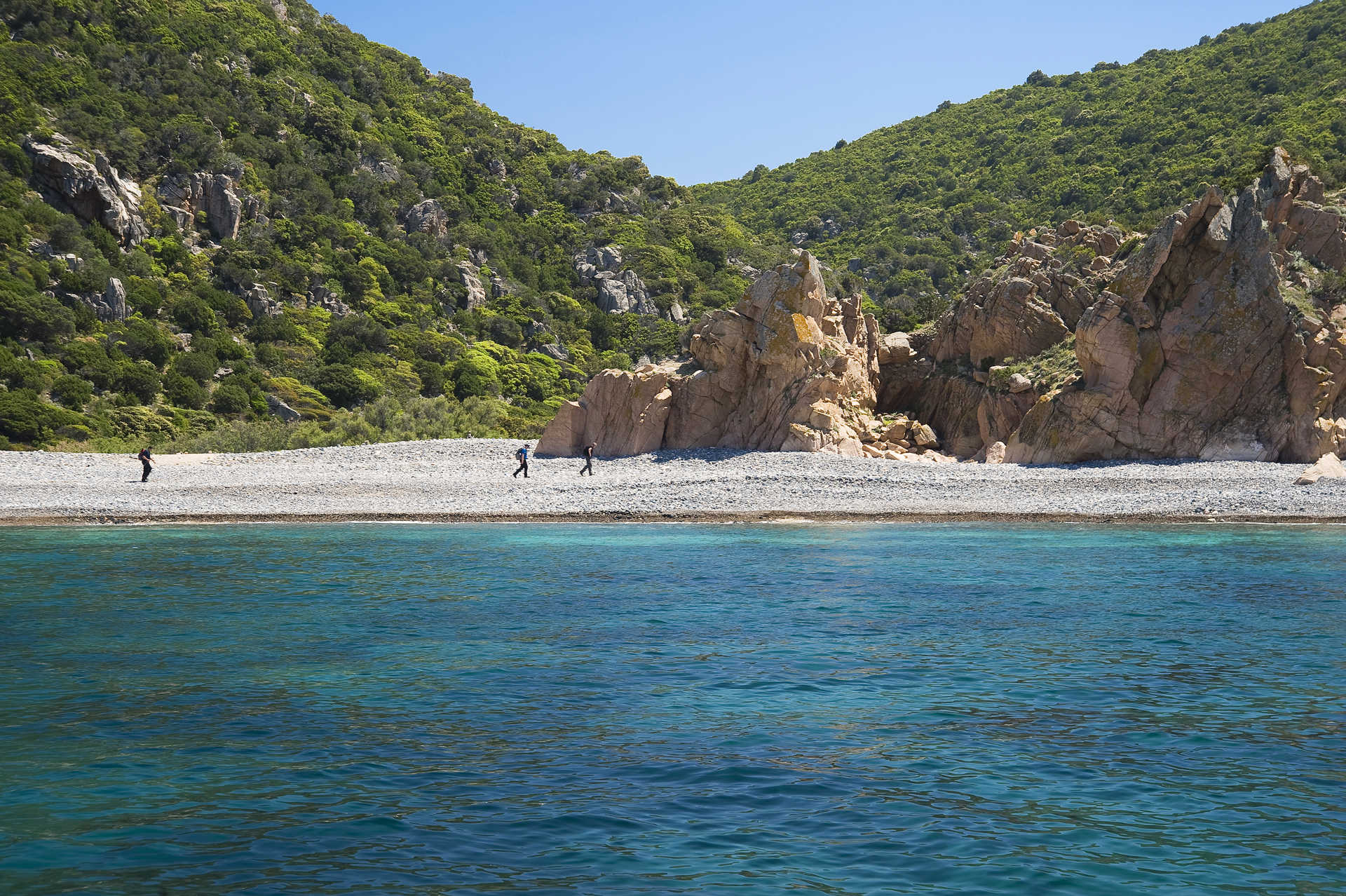
A long and charming stretch of coastline with soft, white beaches and a beautiful hinterland, which contains the flora and fauna reserve of the Zincu Denti forest. The two residential areas of Trinità d' Agultu and Vignola form a single Municipality with two thousand inhabitants, in the northwestern part of the Gallura region. Formed in the second part of the nineteenth century by families from nearby residential areas and stazzi, Trinità d'Agultu, the municipal 'capital', towers over the shoreline from an altitude of 350 metres. In the centre, the eighteenth-century church of the Santissima Trinità stands out and contains the statues of St. Barbara and St. Orsola, deriving from the ruins of two little medieval churches. There are solitary sanctuaries scattered around the countryside: those of Sant'Antonio, San Pietro Martire, San Giovanni, San Giuseppe, San Michele Arcangelo on a panoramic hill, and that of Santa Maria di Vignola, near the coast, in the centre of the second municipal urban area. The vineyards produce excellent Vermentino wine, ideal as an accompaniment to fish recipes: zimino (fish soup), linguine pasta with sea urchins, grilled fish. From the land, a special dish: zuppa gallurese (Gallura soup), a dish with bread, Pecorino cheese and sheep meat broth.
Vignola includes the district of Lu Colbu and the marine district of Costa Paradiso, a granite landscape covered in Mediterranean scrub and punctuated with little coves. The colours of the sea range from green to blue and light blue. Li Cossi is a masterpiece of nature: fine, golden sand set amidst the pink rocks. Other beautiful places include Cala Sarraina, which has always been a natural harbour, the little coves of Porto Leccio and the romantic bay of Li Tinnari, shaped like a double arch, made of crumbled shells, grains of granite and round pebbles. Isola Rossa is a seaside village located six kilometres from Trinità and it got its name from the little island in front of it. Its modern harbour is dominated by a Spanish tower that dates back to the end of the 16th centre. It is an ideal place for snorkelling and diving. Around it there are countless little coves: La Marinedda, one of the most beautiful beaches in northern Sardinia, will strike you with the contrast between the blue sea, the white sand, the red rocks and the green vegetation. Its continuation is the beach of Spiaggia Longa. Other breathtaking inlets are Cala Rossa, with its light sand, pink rock and transparent sea, Cala Canneddi, with its combination of multi-coloured little stones and the secluded Li Feruli, with its cream-coloured sand.
The most ancient traces of human presence in the territory are from the Mesolithic period, in the shelter under the rocks at Porto Leccio. Dating back to the Neolithic period, there is the Conca di Li Fati, a grotto dug out of the granite rock and a very rare case of a Domus de Janas in Gallura. The most important evidence of the Bronze Age is the Nuraghe Bastianazzu, to the west of Isola Rossa: it is a complex building made of granite rocks and its purpose was to control the coast.
Cala Drappo
To the west, Cala Drappo overlooks the Island of Santa Maria, in the commune of La Maddalena. The coast is extremely rugged, lapped by a sea dotted with numerous minor islands. Indeed, its very name recalls a church dedicated to the Virgin Mary which was annexed to a destroyed monastery, mentioned in a document dating to the Middle Ages, and of which possibly some traces can be seen incorporated within a private house. The beach of Cala Drappo is a half-moon of light-coloured stones and pebbles which plays with a splendid sea, whose colours range from blue to green. In the background, the beach is edged by rounded pink rocks, where the verdant vegetation of Mediterranean shrub creeps.

Sa Jara Manna - Giara di Gesturi
An island within the Island, a magical place with unique characteristics. The Giara is a basalt plateau on the border between the Marmilla and Sarcidano regions: it rises abruptly to an altitude of 550 metres, dominating the surrounding flat landscape, rippled only by ‘gentle’, fertile hills. On the top, there is a twelve-kilometre long and slightly sloping ecosystem where rare animals and plants are preserved. To differentiate it from the nearby ‘smaller’ Giara plateaus of Serri and Siddi, it is called Jara manna (large), or Giara di Gesturi, a Municipality containing approximately half of its entire area (45 square kilometres). The other half is divided between Genoni (1600 hectares), Tuili (450) and Setzu (250). Its area also involves Albagiara, Assolo, Genuri, Gonnosnò, Nuragus, Senis and Sini. Each one has nature, archaeological and artistic sites and ethnographic museums, covered by a network of itineraries that can be enjoyed on foot, by bike or on horseback.
‘Giara’ may have evolved from glarea, or ‘ghiaia’ in Italian (meaning gravel), indicating the stoniness of the ground. Its origin comes from lava flows during eruptions that took place 2.7 million years ago on a sandy bedrock from two craters that are now extinct: Zepparedda, summit of the plateau (609 metres), and Zeppara Manna, the most scenic point. It was not the plateau that rose up but the surrounding lands that were lowered, as they were not protected by effusive rock and were eroded by water and wind. Sa Roja lies between the two volcanic cones and is a fault that runs across the plateau with a step of 30 metres. The steep sides have been ‘affected’ by landslides generated by torrents that arise at the springs of the plateau and descend along the edges. This is the origin of is scalas, access routes to the plateau, of which you will discover the geological history in the Geo-paleosite of Duidduru, and in the Paleo Archaeo Centre di Genoni. The isolated location has maintained a plant and wildlife heritage that has disappeared elsewhere, thanks to which Giara has been a site of European Community interest since 1995. It is covered in lush woods, centuries-old species of cork oak, often ‘forced’ to grow slanted by the northwesterly ‘maestrale’ wind. Then there are holm oaks, downy oaks, strawberry trees, lentisk trees and myrtle. In spring, the plateau is filled with colours and scents: there are helichrysum, asphodels and cysts are in bloom, as well as expanses of cyclamen and orchids and a yellow cloak of morisia, an endemic plant that gives its name to the botanical garden in the park. The most spectacular places are is paulis, depressions where rainwater stagnates. There are dozens of them, mostly modest and of short duration. In some cases, they are quite big and they last throughout the year, as with the two named pauli maiori. In springtime, the ponds are covered with a white cloak of buttercups, while in summer they dry up and look like ‘lunar’ expanses. The autumn rains colour them with the dark red of the tamarisk trees and a thin layer of ice often covers them in winter. They are the habitat of a rich microfauna, including two tiny crustaceans, ‘living fossils’ unchanged for millions of years. They are also the home of the western marsh harrier, the black-winged stilt and the mallard. The plateau is famous for its small horses, a unique case of a wild horse colony in Europe. Is cuaddedus gallop in small groups between the bushes, take shelter in the shade of the cork oak woods, drink in the pauli and are greedy for buttercups. Their origin is lost somewhere between legend and history. In the Middle Ages, entire herds populated the island and gradually disappeared. Today, about 700 of them graze in the wild on the Giara plateau: they have a thick mane, a long tail and a slender build, giving them surprising grace despite their size and wild nature. Completing the wildlife, there are wild boar, weasels, hares, martens, foxes and 60 species of bird, including various birds of prey.
The Giara is an unassailable natural fortress, with escarpment walls similar to bastions. A long bulwark against invaders, today it contains traces of a very distant past. A system of nuraghi presided over is scalas: there are 24 of them on the summit, mostly of the single tower type; the double ones and those with two or more towers were lined up at the foot and on the slopes. On the southeastern edge stands the Bruncu Madugui, the most impressive Sardinian protonuraghe with the remains of huts grouped in blocks. Some complexes were also frequented during the Punic-Roman era: Pranu Omus in Genoni, Santa Luisa in Tuili and San Lussorio in Albagiara; others arise next to springs: such as the nuraghe Scab’i Ois, near the spring of the park of Cracchera. The Giara is crossed by the longest stretch of paved Roman road on the Island: seven kilometres! In the Middle Ages only shepherds were already frequenting the plateau: evidence of this is le pinnettas, shelters similar to Nuragic huts.
Olzai
The town looks over a valley, surrounded by ancient woodland and set among impressive mountain peaks that acted as refuge and points of control in antiquity. Olzai is a small town in the Barbagia di Ollolai, with a wealth of traditions and events that take place in November as part of the Autunno in Barbagia event. It played a key role in the medieval Sardinian struggle against the Catalan-Aragonese invaders. Even after conquest, it remained hostile to its Iberian rulers. In the early 20th century it was named "the town of the graduates" thanks to its high rate of literacy (for the time) and number of graduates. Today, the 900 inhabitants have held on to ancient customs: bread-making, engraving and choir music. The paved roads and alleyways of the historical centre are lined with granite houses, set around the 14th century Church of Santa Barbara, who is celebrated in late August. Inside the church is an 18th century wooden cross, used for the s’Iscravamentu during Holy Week, and the famous Retablo della Pestilenza by the ‘Maestro d’Olzai’. Other fine examples of religious architecture include the Church of Sant’Anastasio (XVI 16th century) in Catalan-Gothic style, which hosts the Retablo della Sacra Famiglia and the 15th century parish Church of San Giovanni Battista – whose patron saint is celebrated in late June - which was extended in the 17th century and completed with a belltower in 1738, and which has a marble altar and inlaid walnut choir. Don't miss the house-museum of artist Carmelo Floris, the town's most famous personage. The art gallery in the town hall is also dedicated to him, and has a collection of more than 250 works. The painter/engraver was constantly inspired by the fairy-tale Olzai landscape, which is ideal for excursions along paths that climb to peaks from which you can admire boundless panoramas, from Gennargentu to the Tirso valley.
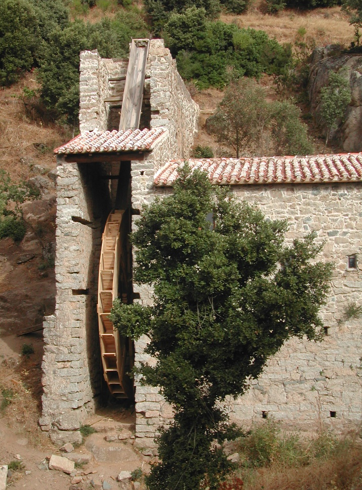
Following a devastating flood, a monumental flood barrier was built in the centre in 1921 to contain the River Bisine. The winter floods were used to drive the watermills and grind grain up until the 20th century. Just outside the town, you can visit the last functioning watermill (of the seven that were in function in 1911): su Mulinu vezzu. Built in granite, it is a majestic work of pre-industrial hydraulic engineering, surrounded by nature. This is the starting point for the climb to Mount Gulana, cloaked in holm oaks and home to rare birds of prey, with natural attractions such as su Nodu de su malune. On the peak, you will find enormous blocks of stone, where a castle, possibly Byzantine, used to stand; it is mentioned as far back as the early 19th century and is surrounded by legends of fantastic treasures hidden in the cellars. To the south-west is the artificial Lake Benzone, used to produce electricity and a habitat for eels, carp and trout. The nearby hills are dotted with the remains of 11 Nuraghes (of 17 catalogued in the early 20th century). The main Bronze Age remains are the Giants' tombs s’Ena ‘e sa Vacca, long believed to be a dolmen due to the slab used to cover them, but with the typical rows and exedra structure of Nuragic tombs.
Viddalba
Extending along the edge of the fertile plain of the lower Coghinas, Viddalba is a town with 1,700 inhabitants where the Gallura language and traditions are kept alive. In western Gallura bordering the Anglona, just south of Badesi and a short distance from the beautiful beaches of the Gulf of Asinara, it is the perfect destination all year round for sailing, windsurfing and kitesurfing. The village was built in the Middle Ages, rising up in the area called Vidda Ecchja. Its name appears for the first time as Villa Alba (‘white town’), in the condaghes of San Pietro di Silki and San Michele di Salvennor (11th-13th century). According to folklore, the hamlets around the main town were the raided by the ‘Muto di Gallura’, a deaf-mute bandit in the late-19th century who marked local history. Originally, the area relied on animal farming. Today, the local economy is based on tourism, agriculture and particularly the cultivation of watermelons, potatoes, tomatoes and - above all – ‘spiny’ artichokes, flanked by handicrafts, especially processing fabrics, wrought iron and stone.
Trekking and horse-riding enthusiasts can travel through the scents of the Mediterranean, along fascinating rural roads in the stazzi and on the heights that delimit the territory to the east. The paths lead to the peak of Monti Ruiu, crossing intensely-red rocks, and to Monte San Gavino, where twenty ‘studded streets’ form the playground for lovers of paragliding and climbing. At the summit (at 800 metres) stands the Church of San Gavino a Monte, where celebrations are held on 1st May. The Viddalbese section of the Coghinas river flows between pine and eucalyptus woods, rich in eels, carp, bass, tench, and populated by herons, coots and common moorhens. It is home to sport fishing and a destination for kayaking and bird watching. On the bank of a river just a short distance from the village, there is the Terme di Casteldoria, with salt-bromine-iodine waters with healing properties, already exploited by Roman, Doria and Aragonese populations, flowing at over 70° Celsius. The river continues downstream to join up with the bays of Mount San Giovanni, where there is a park, panoramic platforms and the Romanesque church of San Giovanni Evangelista, dating back to the 12th century only to then be rebuilt from ex novo. The simulacrum of the saint is kept in the Chiesa di San Leonardo. Festivals and food fairs are accompanied by traditional rhythms and costumes, occasions to taste Zuppa Gallurese, meats, cheeses and wines. Amongst the events, one stand-out is the Matrimonio Gallurese (‘Gallurese Wedding’) stands out, with poetic competitions, parades on horseback, songs and dances.
The Viddalba plain has been frequented since the Neolithic period, as is shown by the Domus de Janas, inhabited assiduously since the ancient Bronze Age (18th century BC). Near the Sanctuary of San Leonardo, the ruins of a Nuragic village can be seen, amidst which the vast Necropolis of San Leonardo rose up between the end of the 3rd and 4th centuries AD, from which precious funerary objects and dozens of decorated funerary stelae have come to light, which were the ‘markers’ of incineration tombs, now kept in the civic archaeological museum, one of the main exhibitions in the province of Sassari. It is dedicated to testimonies of the entire lower valley of the Coghinas: from ceramic finds from the Neolithic, Lithic and Eneolithic period through to the Punic, Roman and Renaissance coins.
Sedini
Some of its oldest houses were hewn into the limestone of a plain at 350 m above sea level, nestled in gently rolling hills and waters of the Asinara Gulf. Sedini has 1,300 inhabitants and is in the Anglona region, home to remarkable nature, ageless cultural traditions and prehistoric remains, like the domus La Rocca, the “cathedral of the domus de Janas.” It is one of Sardinia’s most unusual pre-Nuragic landmarks and is right on the town’s main street! It’s an enormous rock at the edge of the Baldana valley that is home to an underground burial site dating to the IV-III millennium BC. The site was used for the extraordinarily long time of 5,000 years, from the Neolithic Age to the XIX century. Its transformation over the course of time, especially the Middle Ages, made it an important part of the town: it was used to make bricks, it was a prison, animals were kept there, shops opened and dwellings inhabited. It is now home to the Anglona Museum of Ethnographic Traditions, which tells the history of rural life in the area and of the archaeology, starting with the Neolithic tomb, the oldest part of the Rocca: six cells of varying shapes and sizes, two of which connected in a single room. The plains above town are dotted with caves that served as dwellings in pre-historic times: Li Conchi, Li Caadaggi and La Pilchina. The Fossa de la Loriga, inside the Lu Padru hill, is also fascinating, home to stalactites and stalagmites in rooms with ceilings as high as ten metres. Nearby is the white Lu Padru nuraghe, white because it was made of limestone blocks. The inner chamber has been preserved intact.
The old centre of town is graced with steep stairs and narrow passageways, unique in its genre for the scenic effect created by the houses that seem to cling to the rock face, even hewn into it at times. The meat, cheese, honey and wine here are of remarkable quality, and the baked goods (ozzaddini, origlietti, frijoli and cozzuli di pilhtiddhu) are an important part of the cuisine. The lovely church of Sant’Andrea – the patron saint celebrated in November – dates to 1517 and was restored at various times in the 1800s and the 1900s. It is home to a copy of Raphael’s Transfiguration by Andrea Lusso (1597). The interior varies between late Gothic and Renaissance.
The town is blessed with breathtaking views all around, especially over the Silanis River valley, rich with streams, cliffs, mills and medieval churches, including the ruins of San Nicola di Silanis. This church, built over what was once a Benedictine monastery, can be found in the village (abandoned) of Speluncas, built of limestone blocks in 1122 at the behest of the Zori family, aristocrats who moved in the higher circles of the Torres guidicato. The church is remarkable for the purity and perfection of its architecture. Another monument not to be missed is the isolated little church of San Pancrazio di Nursi, the only building that remains of a XII century monastery. The walls are made of alternating limestone and lava rock.
Berchidda
It lies on the southern slopes of Mount Limbara, the 'mountainous heart' of Gallura, that surrounds it with granite rocks shaped by the weather, not far from Lake Coghinas. Berchidda is a village with three thousand inhabitants, with Neoclassical and Art Nouveau houses and buildings positioned in a 'crescent' shape in steep streets. In the centre, you will find the parish church of San Sebastiano, with its wooden Baroque altar, and the seventeenth-century church of the Rosary. From the main square, you can enjoy a breathtaking view of the valley and Mount Acuto, an elevation that gives a name to the territory. On the occasion of Time in Jazz, which lasts for a week, around the 15 August Ferragosto holiday, the village puts on its best clothes, the squares become a theatre, the streets come to life with the colours and sounds of the nighttime concerts, starring the famous trumpet player, Paolo Fresu and musicians from all over the world.
By day, the rural churches of Santa Caterina and Sant'Andrea (seventeenth century), as well as the garden of the butterflies on Mount Limbara are settings in which the musicians improvise, inspired by the silence and beauty of nature. Berchidda's fame grew throughout the world at the same speed as Fresu and the international festival, which has been the key event of the island's jazz circuit.
Near the village, at an altitude of 500 metres, you will find the castle of Montacuto, built in the 11th century, a political and military centre and witness to the local medieval events taking place: it belonged to the Judges of Torres and those of Arborea, was the object of a dispute between Pisa and Genoa and, in the end, fell under Catalan rule. The remains of walls, a tower and a cistern still remain. The territory is rich in evidence from prehistoric times: tafoni and inhabited caves, Domus de Janas necropolises, dolmens, megalithic structures (Pedriscalas and S'Iscala Serrada), tombs of Giants and nuraghi. There are numerous Roman traces: Republican coins, the remains of the Olbia-Turris Libisonis and a bridge along the Silvani river. The road and fortifications of Su Casteddu indicate that this was once a transit area disputed between the "Romanized" and rebellious populations (the Balares).
The village is surrounded by the colours and fragrances of centuries-old oaks and holm oaks, brooks and little waterfalls, like that of Su Pisciale. The territory is populated by deer, fallow deer and mouflons, while northern goshawks and Eurasian sparrow hawks fly overhead. Then there are the vineyards: Vermentino di Gallura is produced here and is the only Sardinian wine with a DOCG (controlled and guaranteed designation of origin) label. The wine museum is located at the foot of the hill of Sant'Alvara and it retraces the history of grape-growing in Sardinia. Associated with it, is the regional wine shop, where wine tasting takes place and wine is sold. The wines from the local wine cellars accompany a unique culinary experience: things you should absolutely taste are sospiri, almond cakes, and suppa cuatta, 'flat breads' in sheepmeat broth, fresh and mature pecorino cheese. Other delicacies are maccarones furriados and sas laldadinas, filled pasta parcels. The economy is also based on cork processing and on breeding, to which the sheep festival is dedicated, taking place in May. Eagerly anticipated events are the rural festivals of San Marco (25 April), San Michele (mid-May) and Santa Caterina (beginning of June), where you can discover authentic flavours (cured meats, cheeses, cakes and pastries) and admire splendid traditional clothes.