
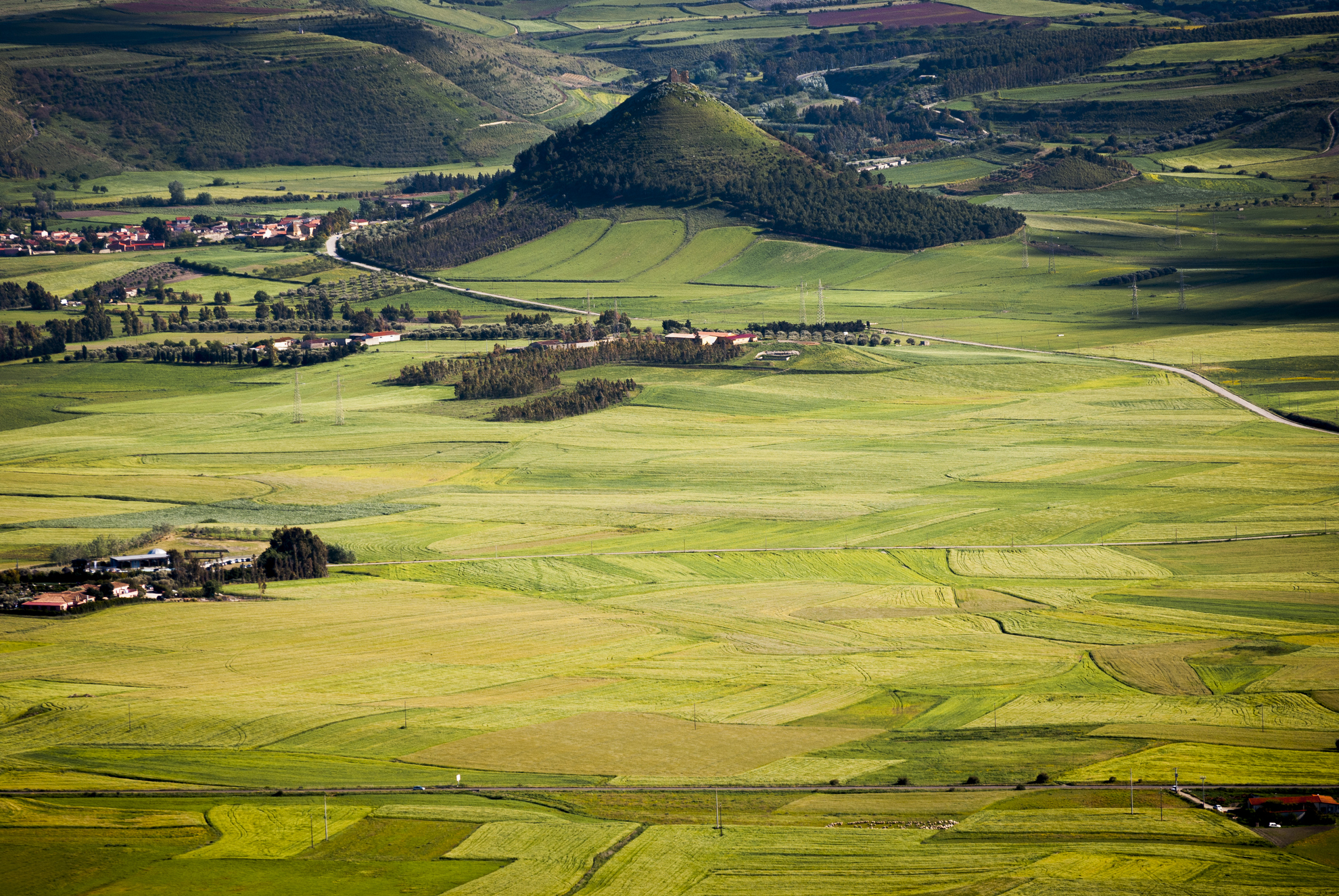
Las Plassas
The town came into being during the Middle Ages at the feet of a castle as the groups of structures around it, sas plassas, came together to form a village. Las Plassas is one of the island’s smallest villages, with only 250 inhabitants. It rises in the fertile valley of the Flumini Mannu, its characteristic low houses graced with expansive courtyards nestled around the parish church of San Sebastiano, the patron saint whose feast day is celebrated in January with a huge bonfire. The church dates to the middle of the XVII century and has since been renovated. The town’s main church is Santa Maria Maddalena, a renaissance building constructed at the feet of the castle between the XVII and XVIII century over the ruins of a Byzantine structure. It had a Greek cross floor plan that was then changed into a Latin cross. The octagonal dome and bell-gable with a XVI century bell are all that remain of the original structure. On the outskirts is Santa Maria di Monserrato (late XIV century), home to a Nuragic Age sacred well. It was built in an historically frequented area, nearby is a Punic-Roman oven. Three cross arches divide the hall into four sections. The most heartfelt celebrations here take place on 8 September, while a yearly legume festival is held in late September.
The first outpost of the Arborea Guidicato, Las Plassas became the seat of the powerful Aragonese family, Zapata, its liege, who lived there until the late XX century. An example of the flourishing economy of the Middle Ages, the remains of the Marmilla Castle (or Castello di Las Plassas) are among Sardinia’s most picturesque, isolated on a lone and perfectly conical hilltop that looks out over the plains below. Built in the XII century, it was of military importance, the fortress of the Arborea Guidicato and a mainstay in the war against the Crown of Aragon, under which it fell after the sa Batalla at Sanluri (1409). Some of its rooms served as prison cells until the 1800s. The main tower, walls, perimeters and interior can still be seen today, as can the large well hewn into the rock. The connections between the rooms are worth noting. During archaeological digs some of the furniture, ceramics (XII-XVI centuries) and other relics were discovered, now on display at the MudA museum, located in an XVIII century residence. A multi-media route ends with a film about the visit to the castle by Mariano IV, the ruler, and will take you into medieval Sardinia. A part of the museum is archaeological. Of interest is an epigraph from the 1st century CE, when the local Uneritani population dedicated a temple to Jove. The village was then part of a Uselis colony. Many Nuragic monuments were reused in the Punic-Roman era. The most important of them are the single towered Perdedu and Bruncu e Forru, the five-lobed s’Uraxi and the XIX century BCE giant tomb of Mesedas. The area has been populated since the Neolithic Age, as proven by the Pranu Sonàllas site.

Gonnesa
It is located in the gorge of Gutturu Carboni, at the foot of mount Uda, in an area rich in deposits exploited since Antiquity. Gonnesa is a village in the Iglesiente area, with approximately five thousand inhabitants, that extends around the church of Sant'Andrea Apostolo, built between the 11th and 13th centuries in Romanesque style, which is very clear when looking at its façade. Since the 14th century, it has been characterized by extraction activities, which became very intense from the beginning of the nineteenth century until after the Second World War. In May 1906, the centre was the stage of an uprising, the purpose of which was to demand more humane working conditions, but this was violently repressed by the police (three dead and 17 injured). Agricultural tradition is also strong: it returns in August during the feast of traditional bread and at the beginning of September during the celebration of Sant'Isoldoro in the Nuraxi Figus district.
Sites that have fallen into disuse bear witness to the historical mining period. These sites are located in the woods of Mount Onixeddu, Seddas Moddizus and Mount San Giovanni, where the village of Normann is situated. Here, the mine is near the grotto of Santa Barbara, a gem of unspoilt nature, with a small lake, columns of stalactites and stalagmites and aragonite arabesques. As well as industrial archaeological remains, the territory is dotted with prehistoric sites, like the Domus de Janas on the plateau of Murru Moi and, above all, the most important Nuragic complex in the Sulcis area, the village of Seruci, consisting of a Nuraghe complex, a turreted defence wall, a Tomb of Giants and a village with over one hundred huts, among which there is one with an interesting counter-seat at the base of the wall and another with a rectangular courtyard. Various artefacts bear witness to a considerable Phoenician, Punic and Roman presence, based on their interest in the abundant deposits of silver, lead, copper and zinc.
The splendid coastal stretch of Gonnesa is three kilometres long, delimited to the north by a mining village and to the south by an eighteenth century tonnara (tuna trap).The long coastline of fine sand and crystal clear waters is formed by three beaches: Fontanamare, Spiaggia di Mezzo and Porto Paglia. The hinterland also has evocative surprises in store: from the wild and arid hills to the plateaus of volcanic origin and schist ridges. There is a variety of Mediterranean scrub throughout the territory: strawberry trees, heather, juniper, broom, holm oak, myrtle, wild olive and rosemary. Worthy of a visit is the Sa Masa marshland, inhabited by rare species of aquatic birds, among which the western swamphen and, in certain periods of the year, herons, flamingos and mallards. Also worth visiting are the sandstones of the Quaternary period in Morimenta, where, among the fossils found, an extremely rare example of a dwarf elephant was also discovered.
Giave
High up on the summit of a basalt plateau, Giave is a little village with less than 600 inhabitants in the Meilogu, subregion of the Logudoro region. Its territory is delimited by the plateaus of Campeda to the south, Monteacuto to the east and Sassari to the north. The Romans colonised the area by creating a bifurcation in the road that joined Caralis to Turris on one side and to Olbia on the other. In the old town centre, there are still sections of the late-medieval village: in the centre, you will see the bell tower of the parish church of Sant'Andrea, which was founded in the 16th century, renovated in 1788 and later enriched by a bronze portal. There are also other churches, including that of Santa Croce, in which you can admire an ancient wooden altar, the church of San Sisto, in a panoramic position, and that of San Cosma and San Damiano, a destination for pilgrimages. Through the pinnettas, typical stone huts with conical wooden roofs, used as shelters for the shepherds, you will be able to enjoy itineraries on which you will discover pastoral culture.
A land of extinct volcanos, the unusual landscape around Giave stands out with its natural protected monument of the volcanic craters of Meilogu, small high ground areas of lava origin, sharp, rounded or cut out of flat tablelands. Mount Annaru-Pòddighe, in the Giave area, is almost 500 metres high and it is the most distinctive of five solitary craters: from it, flowed the lava that gave rise to the large tableland to the northeast of the village, Campu Giavesu. It is an ideal destination for excursions: both in autumn and in winter, when a little lake is formed in the crater and also during the hot months when you can walk down the walls inside the crater. South of the mount, you can admire the sight of Sa Pedra Mendarza, an ancient volcanic vent that resurfaced thanks to erosion. The volcanic monolith is 100 metres tall and ravens and northern goshawks nest on its slopes. Near the crater, you will be just a few steps from the Cabu Abbas plain, better known as the valley of the Nuraghi: one of the areas with the highest density of Domus de Janas and Nuraghi. The territory of Giave is also part of it and was already intensely inhabited in prehistoric times. The Nuraghe Oes is undoubtedly the most famous testaments to this and one of the most important in Sardinia. The unusual architecture of the main tower, which is 11 and a half metres high and has a diameter of 16 metres, contains a single tholos room divided into three spaces by wooden slabs. The tower is in the centre of a vast settlement that includes a bastion equipped with two towers, a courtyard, a sacred area with temenos and a little megaron temple, with a village around it.
Baccu Mandara
A picture postcard sea, a well-equipped and accessible beach, surprising landscapes all around. The beach of Baccu Mandara occupies the eastern edge of the Geremeas coast, in the part of the locality belonging to the Municipality of Maracalagonis. It is a three-kilometre stretch of sand, partially interrupted by the mouth of a torrent that increases its flow and creates a lake a short distance from the shore, especially in winter. The small body of water divides Baccu Mandara from the beach of Marongiu and, at the same time, separates the territory of Mara from that of Quartu sant’Elena. On the opposite side, the limit is a small promontory that closes the beach with a rocky arch.
The sea is crystal clear, reflecting shades of light blue, and the sandy seabed slopes rapidly a few metres from the beach. The sand is light with medium-large grains. Behind it, thick vegetation surrounds the entire beach, on which there are also some small dunes peeping out. Baccu Mandara is particularly exposed to the winds, making it an ideal destination for sailing, windsurfing and kitesurfing enthusiasts, while snorkelling enthusiasts can explore the rocks at the foot of the promontory. The beach offers all the services you need: parking, refreshment areas, bathing equipment and boat rentals (pedaloes and canoes), a boat storage area, and it is accessible to disabled people.
While relaxing on the beach, you may notice that you have company: groups of ducks, who often stop off at the little lake formed by the mouth of the river. Remember not to leave before sunset, though, when the sun sets on the horizon, offering fantastic plays of colour, turning the shoreline pink and giving the sand a golden colour. Another surprise awaits you as you move past the cliff around the rocky spur on the left: behind it, a ‘hidden’ crescent-shaped cove, sheltered from the wind, opens up, with shallower waters and sand alternating with small and medium-sized rocks.
You can get to Baccu Mandara by taking the scenic provincial road leading from Cagliari to Villasimius, turning off at the signposted exit. The two previous diversions lead to the Geremeas beaches that share the same coastline, namely Kala ‘e Moru and Marongiu. The first, surrounded by rocks, has very fine, golden sand, waters with shimmering colours and shallow waters, while Marongiu alternates white and golden grains of sand and the sea here reflects shades of green and turquoise. In 2006, for the first time in Sardinia, a loggerhead sea turtle laid her eggs on a stretch of beach with sand dunes.
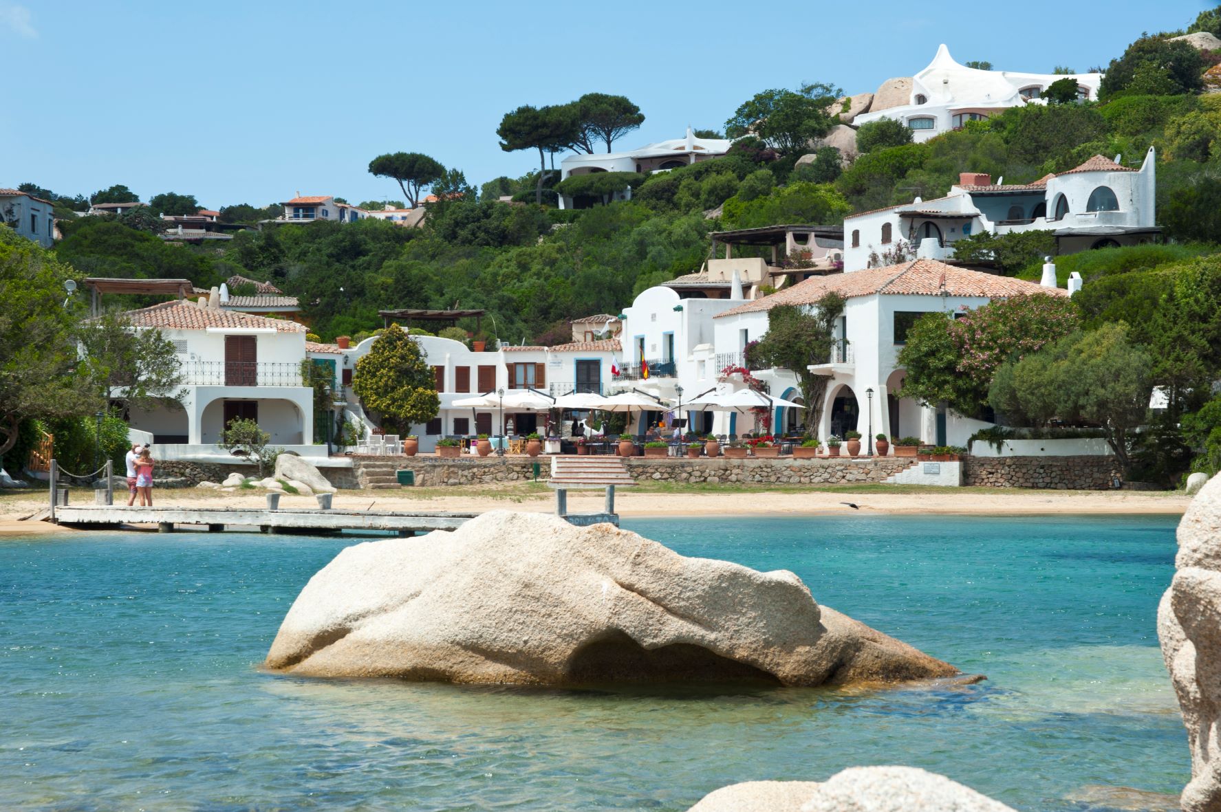
Porto Rafael
A small tourist settlement faces the La Maddalena Archipelago National Park. In Porto Rafael, the predominant colours are the blue of the sea contrasted with the white of the houses within the villages positioned along the extreme northern tip of the Isola, in the territory of Palau, just a few kilometres away, and Porto Cervo, the heart of the Costa Smeralda.
Founded in the 1960s by the Spanish Count Rafael Neville de Berlanga del Duero, the tourist hub is characterised by a quaint piazza overlooking Cala Inglese, also known as the 'Porto Rafael pool', and by the white houses bounded by colourful gardens. It is a popular destination for summer holidays, frequented by personalities from the world of entertainment, yet is also suited to families and lovers of relaxation and a bustling social life. The centre is equipped with all services, whilst also being home to renowned international sailing events during the summer. Not to be missed is 11th August, when a special event is held in the piazza whereby all participants, dressed in a white tunic, dance in honour of the Count who founded the town.
The small marina of Porto Rafael is an ideal point of arrival for small and large boats, as well as for setting out on excursions to the enchanting islands of the archipelago. Just a stone's throw from the village, along the coast of Palau, you will find small beaches of coarse-grained pink sand with small pebbles, all forming authentic natural pools.

The Teti Archaeological Museum
A journey back in time among ex-votos, rings, bracelets, daggers, pins, figures depicting crowds of devotees and warriors who, between the Middle Bronze and Iron Age, frequented the sanctuary village of Abini and the village of s’Urbale. Teti, a pleasant town in the Nuoro region, sits at 900 metres on the slopes of the Gennargentu mountain range. It is steeped in ancient civilisation, details of which have been carefully reconstructed at the regional archaeological museum, housed since 1990 in a building constructed in the oldest part of town. As you visit the rooms, you will catch a glimpse of life as it was in s’Urbale, walking through a detailed full scale reconstruction of a typical dwelling, and you will uncover the secrets of Abini via the relics found at the vast settlement that surrounded the meeting field and sacred well, a place of sacred rites, most likely linked to water worship.
A large number of Nuragic bronze items were found at the sanctuary: anthropomorphic statuettes, reproductions of animals and sailing vessels, as well as raw pieces waiting to be shaped. One especially interesting piece depicts a demon or warrior with four eyes, four arms and a double shield. The museum also houses relics from the Atzadalai plain, including a female idol dating to the late Neolithic Age and several relics from the countryside around the nearby towns of Mandrolisai, Tonara, Sorgono and Meana Sardo. Other material recovered from the two main Teti sites is at the National Archaeological Museum in Cagliari. You will be led by museum guides to visit the digs at the two villages, and in one of them you’ll be able to see a hearth made with a layer of clay that would be periodically replaced, and that may have been the cause of a violent fire that forced the entire population to abandon the village.
The museum exhibition is located in the historic centre of town near the church of Santa Maria della Neve, the patron saint celebrated in early August. At Teti you will find archaeology, ancient places of worship and even some cultural treasures, like the ethnographic exhibits of casa Satta and casa Mereu. During Autumn in Barbagia festivities, you will enjoy the heady aromas and flavours of the local cuisine when private homes open their doors to visitors to enjoy rural traditions together. The views are also enchanting, great for nature walks through green woods of ancient oak and cork trees, of chestnut, cherry and Mediterranean brush. It is here that deer, mountain goats and foxes live, it is the reign of rare birds of prey like the Royal Eagle, who nests on the summits here.
Porto Campana - Chia
A long stretch of soft warm golden sand, a wide sloped beach throws itself into a sea graced with hues of emerald green and turquoise. On either end are promontories covered in intensely aromatic Mediterranean vegetation, species of mastic and white cornflowers border the beach that faces the southern Mediterranean. Behind the beach are dunes that are home to ages-old junipers, cistus bushes and white sea lilies: this is how Porto Campana presents itself, a long and scenic beach with unique characteristics that set it apart from the many other coastal gems of Chia, a renowned tourist resort in the Domus de Maria area. This enchanting beach is extensive, graced by dunes covered with small shrubs that provide a stunning setting, a beach that is often used in advertising campaigns. The shallow water and the colours bring to mind tropical scenarios.
The water here is shallow, making it ideal for families with young children, who can play at the water’s edge in complete safety. A bit further out to sea is one of the most popular snorkelling and underwater fishing areas, rich in fish for all to enjoy. Behind the beach there is also a golf course and a resort. You can hire beach chairs, umbrellas, boats and dinghies, and get snacks and refreshments at any of several stands. The beach is a favourite of water sports enthusiasts, especially wind and kitesurfing, and water skiing. The ample parking lot makes it easy to get to the beach. Capo Spartivento, a habitat for grey herons, coots and egrets, is not far away.
An eastern cliff separates Porto Campana from the beautiful Cala del Morto cove, surrounded by pink granite rocks and blessed with fine golden sand. Further east, near the Chia lagoon, you will find Monte Cogoni and Sa Colonia, bound in by a promontory dominated by the Chia tower, at the base of which lie the ruins of the ancient Phoenician city of Bithia. Beyond the cliff are the beaches of su Portu and the wild and beautiful Isula Manna. To the west of Porto Campana is s'Acqua Durci and, separated by a small cliff, Su Giudeu, a spacious haven of super-fine white sand, considered the most beautiful beach of the entire south-west of Sardinia. It boasts an islet about a hundred meters away that can be reached on foot (or, at high tide, by swimming). The crystalline water here is almost unreal. The last beach west of Chia is Cala Cipolla, a small bay with a huge visual impact. In order to view the entire coastline, we suggest you take a walk to the nearby lighthouse that stands at the south-western extremity of Sardinia. The views from the top are breathtaking and it is often used as a backdrop for movies and advertising.
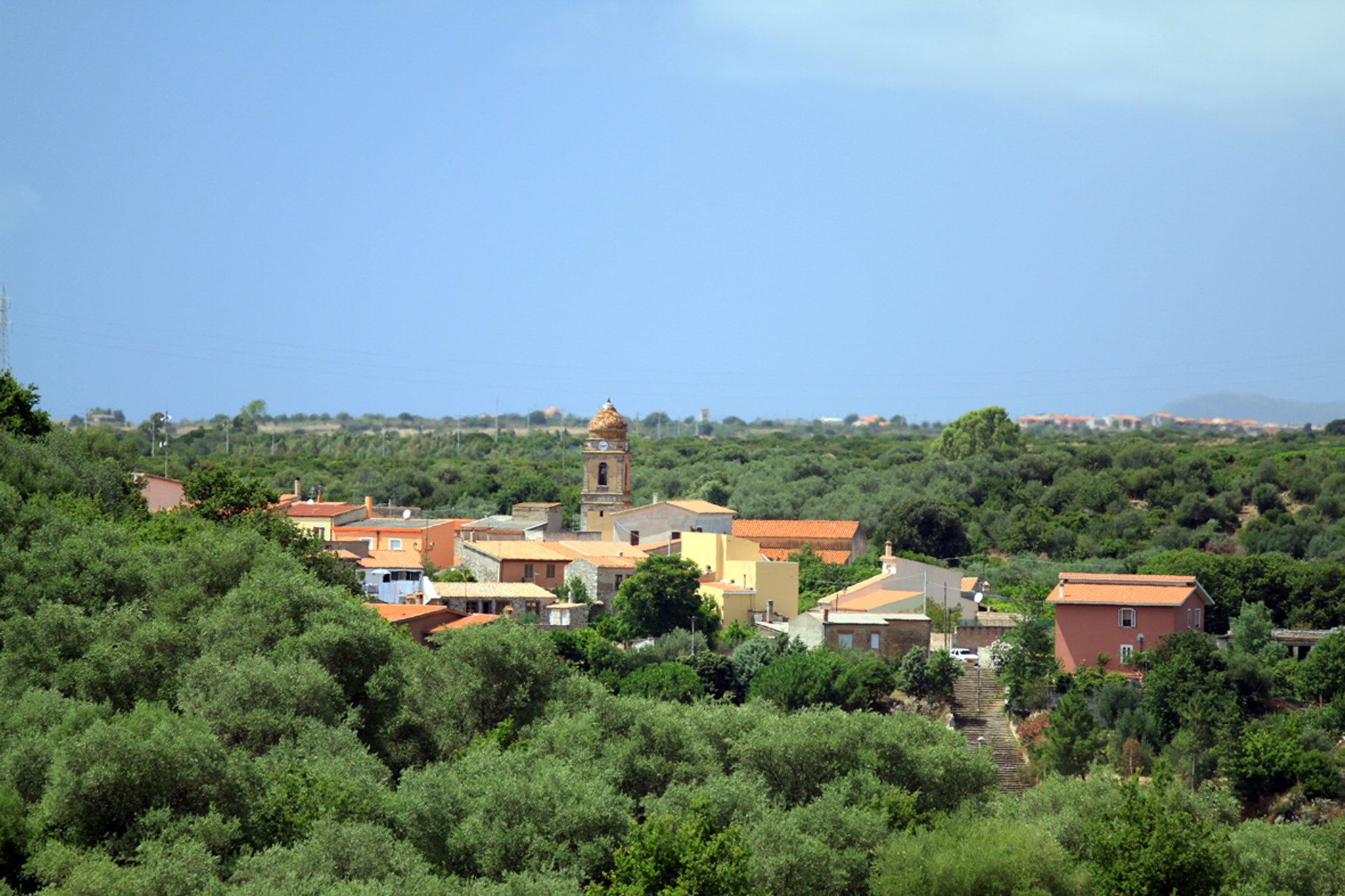
Sennariolo
Set at an elevation of 400 metres, on the western slope of Montiferru, overlooking the valley and Su Tonodiu river, which marks the border with Planargia. Sennariolo is one of the smallest towns of the island (under 200 inhabitants), but one that boasts a rich scenic and archeologic heritage and is a member of the Borghi Autentici d’Italia Association. It is known for its sheep milk cheese, beekeeping and olive groves, where excellent quality honey and olive oil are produced. The more notable typical recipes include lamb intestines with aromatic herbs; stuffed snails; ravioli with potatoes, mint, fresh and pickled cheese; and the sweet cattas, spiral fritters made at Carnival.
The town has a typical agro-pastoral layout: an interlacing of narrow streets and alleys. The low, adjacent houses with spacious courtyards are made of basalt and sandstone, with facades adorned with imposts, architraves, cornices, and murals. In the north-east corner of the historical centre, stands the Parish of Sant’Andea Apostolo, which dates back to 1676, as inscribed in the red trachyte beam over the entrance. The church is composed of a single nave with two chapels on each side and a presbytery all with barrel vaults. Inside, the stonework of the supporting structure is exposed. Adjacent to the façade, stands a beautiful bell tower, completed in 1867 and composed of three orders with an onion dome covered in multi-coloured majolica tiles. Here, the patron saint’s Feast Day is celebrated on November 30. A few kilometres from the town, the ruins of the Shrine of San Quirico and the Church of Santa Vittoria can be admired. Set at the top of a scenic hill, the church was built in thanks for victory over the invading Moors. St. Vittoria’s feast day is celebrated mid-May, while San Sebastiano’s, marked by a great bonfire, on January 20. Among the religious celebrations, the rituals of the Holy Week are also evocative and fascinating.
Next to the town flow Rio Mannu and Rio di Marale, full of trout and eels, as well as Funtana Ezza, the town’s ancient spring. In fact, the name of the town may derive from s’ena ‘e riu, meaning headwaters. It’s perfect location and abundant water resources have ensured its occupancy since the Neolithic, as demonstrated by some Domus de Janas. The area was also populated during the Bronze age, as seen from Giant’s Tombs and numerous nuraghes, including Fromigas, Murcu, s’Ena e Tiana and above all Liortinas, which guards the confluence of the two rivers. A rare and imposing example of a nuraghe with a circular corridor, accessible for two thirds of its length.
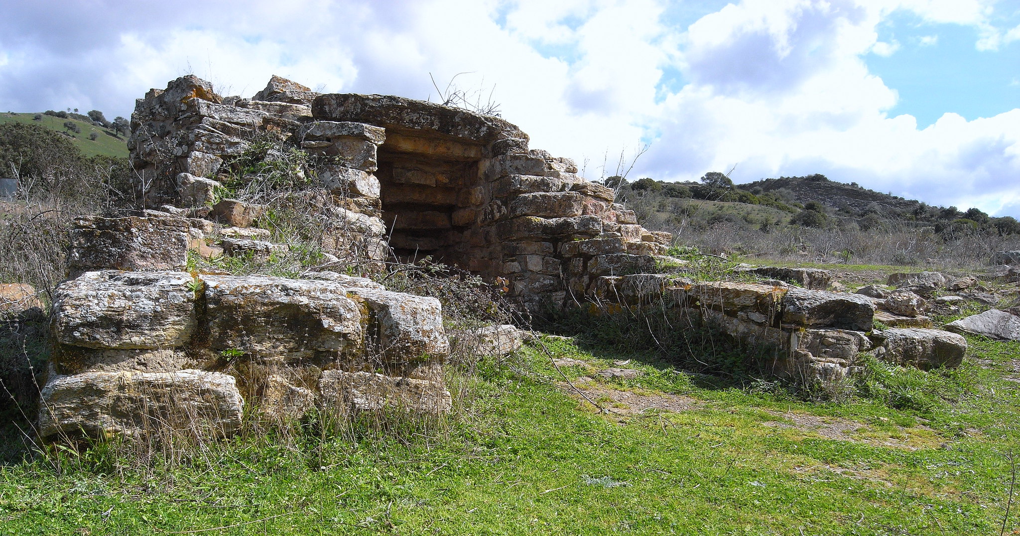
Funtana Coberta
One of the most celebrated, interesting and integral of the thirty-some Nuragic well-temples, where water worship was practiced, its name ‘fontana coperta’ (or covered fountain) well expresses its function and fine state of preservation. Three kilometres from Ballao, a town in the historic Gerrei region – along provincial road SP13 that goes from the town of Escalaplano - is the sacred well known as Funtana Coberta, nestled in a verdant valley floor closed in at its eastern end by a small hill.
The entire 10½ metres long building was built with freshly rough-hewn irregular limestone blocks of equal thickness, squared on the façade. The layout is unusual: two wings of different lengths give rise to an atrium whose original flooring can still be seen today. As with most sacred wells, it is divided into three parts. On the surface is a small, almost two-meter wide, open-air rectangular atrium (or vestibule), a stairway with twelve narrow steps, beautifully finished and covered by a stepped ceiling made up of twelve degrading architraves tucked into the walls to echo the line of the steps below, leads to the tholos-style room. The tholos is itself built in the shape of a small nuraghe, an almost circular 3½ metres wide subterranean room under a 5½ metres high false dome. The care with which the dome was made is remarkable. It has a drum wall where a protrusion marks the location of the stairway and the two wings of the atrium above. The slight convexity of the walls is also remarkable, it seems to beckon the faithful towards the inside of the temple. The floor is made of limestone slabs carefully laid down in a radial pattern. It is here that we find the actual water well, dug some five meters deep into the base rock and covered with 36 rows of stones, with an opening – about a meter wide - from which the spring water flows.
All that remains now of the elevated structures on the outside is the perimeter wall in the shape of a keyhole that encloses the atrium and the drum of the well. One metre from the main room, another rectilinear structure has been discovered, but not yet studied. The shape of the building is similar to that of many other sacred wells, for example the sanctuary of Santa Vittoria in Serri. Surprisingly, it bears a very close similarity to the sacred well of Garlo, a building from the 2nd millennium BC boasting almost the same structure and dimensions brought to light in 1981 in Bulgaria, ancient Thrace, 50 km from Sofia, close to the Aegean Sea. Amazingly, the two buildings differ by only a few centimetres.
The archaeological digs were begun in 1918 by Antonio Taramelli, and then restarted in 1994 (until the most recent activity in 2008), when it was possible to date the temple to between the 13th and 9th centuries BCE. Most of the finds consist of ceramic fragments from the Recent to Final Bronze Age. They are fragments of careened vases with oblique shoulders, hemispherical bowls and necked ollas. There were only a few finds of Nuragic crockery, most dating to the Roman Age. The bronze artifacts found are bits of ox hide, fragments of votive swords and small bronze pieces, such as the head of an archer, the ear of an animal and a foot with base.
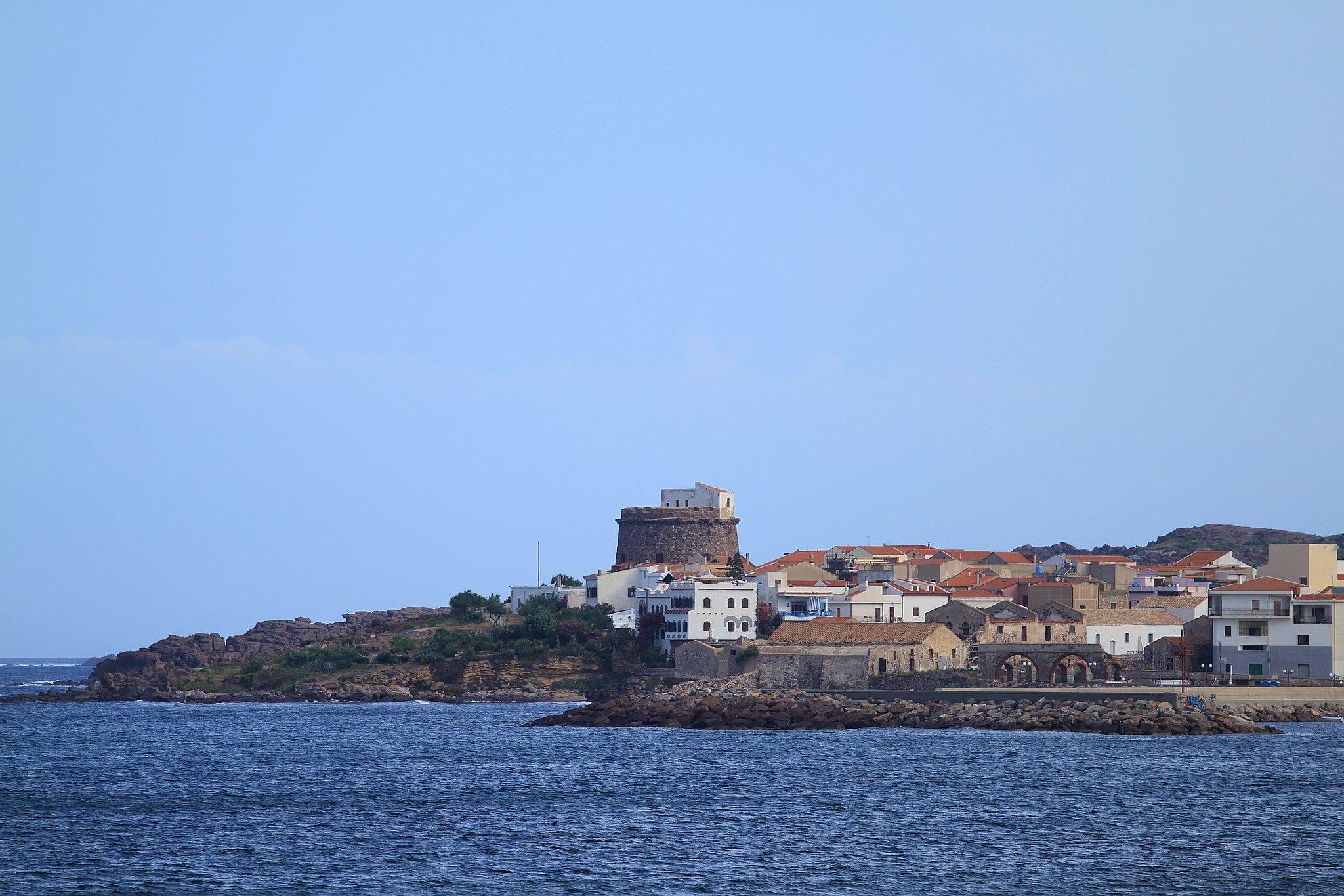
Portoscuso
Its port stands before the enchanting San Pietro Island and connects Sardinia to Carloforte, one of the major tourist resort islands. Portoscuso, populated by over 5,000 inhabitants, was founded in the late-16th century during Spanish domination, as a village based on fishing and coral miners hailing from Sardinia and also Sicily, Ponza, Marseille and Majorca. From the village of Puerto Escuso (‘hidden port’) grew an important commercial port, protected by a 16th-century tower in tuff and trachyte. Rising up on a hill, it offers wonderful views spanning from Cala della Ghinghetta to Portopaleddu (or Porto Paglietto), two beautiful coastal attractions with clear seas and fine sand. Next to the tower rising up in the mid-17th century is the Tonnara di Su Pranu.
Even today, the historic structure comes to life between May and June for Le Mattanze (traditional fishing activity) with the town, together with Carloforte, being famous for its tuna fishing. Built around Su Pranu throughout the centures were houses, warehouses for processing and the Church of Santa Maria d’Itria (1655), in honour of the patron saint of ‘tonnarotti’ (tuna fishermen) celebrated 50 days after Easter, with sporting events, music and folk dancing. Inside the Tonnara is the Church of Sant’Antonio da Padova. Not to be missed is the Sagra del Tonno (tuna festival), with delicious recipes to be savoured. Together with Sagra del Granchio (crab festival) in June, and the Arrusteddara featuring grilled fresh fish in mid-August, these are the major gastronomic events of Portoscuso. Not to be missed is the Villa Su Marchesu, of the noble Pes di Villamarina, baron of the Isola Piana, another ‘pearl’ of the Archipelago of Sulcis. Surrounded by mineral deposits and vineyards of Carignano, Portoscuso became an important industrial centre with the construction of the chemical pole of Portovesme in the second half of the 20th century. Its coastal territory, as well as soft stretches of sand including the unmissable Is Canelles, is characterised by scenic cliffs overlooking the sea, especially those of Costa Crobettana. The inland area has been inhabited since ancient times. The Domus de Janas of Guroneddu date back to the Neolithic age, the burial caves and megalithic circles of Su Medadeddu and Piccinu Mortu (later becoming a Punic necropolis) date back to the Copper age, whilst coming from the Bronze age are the sites of Punta Niedda and Stangioni (subsequently a Phoenician-Punic and Roman necropolis), along with the Nuraghic structures including Atzori and Bacu Ollasta surrounded by villages of huts. The area was frequented by Phoenician, Punic and Roman populations. The greatest archaeological remnants are in San Giorgio, with a Punic necropolis comprised of eleven sepultures (770-750 BC).