
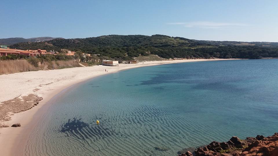
Spiaggia Longa - Isola Rossa
Enchanting porphyry cliffs embrace a hamlet that was once a fishing village and today a tourist resort in the Trinità d'Agultu and Vignola area. The landscape looks like a postcard and the name comes from the Isola Rossa, or Red Island, an islet 500 meters from the coast. The town’s houses and the sea are separated by a long stretch of soft sand with a light colour, with golden reflections and pebbles near the shore, Spiaggia Longa. The sea will delight you with its emerald green hues and transparency, with a shallow sandy bottom in the first stretch. Further offshore it becomes rocky and is a favourite of snorkellers for the great variety of fish that call it home. But there is more to do than just exploring the seabed: you can rent canoes, pedal boats, rafts and jet skis and even go water skiing, while from the nearby port you can go explore the Gallura coastline and the Maddalena archipelago.
The beach hosts a dive centre, restaurants, everything you’ll need for a day at the beach, and not far away is an aquatic park. The quality of the water, the level of environmental awareness and services offered have earned the beach the Blue Flag award of quality, conferred upon it by the FEE (Foundation for Environmental Education).
The area north of the beach – adjacent to the little tourist harbour – is also called “the harbour beach” and is separated from Longa beach by outcrop of red rocks. The southern exposure it enjoys allows it to be particularly sheltered from the winds, especially from the mistral. It has a cream-colored sandy bottom with some flat rocks. You can alternate beach time with a stroll through the streets of the village of Isola Rossa, where you will find eateries overlooking the coast, shops and local craft boutiques. The coast’s sentinel is a 16th century Spanish tower built of red granite, at the foot of which you can gaze out at a wonderful panorama all the way to Asinara.
From the promontory that houses the village are a variety of hiking trails leading to hidden coves. To the north, the first “must” stop is the bay of La Marinedda, set between red granite cliffs and graced with white sand and crystal clear waters. Further along are the natural pools of Cala Canneddi and Cala Rossa, followed by the sheltered, romantic cala Li Tinnari, not far from Paradiso, whose name says it all.
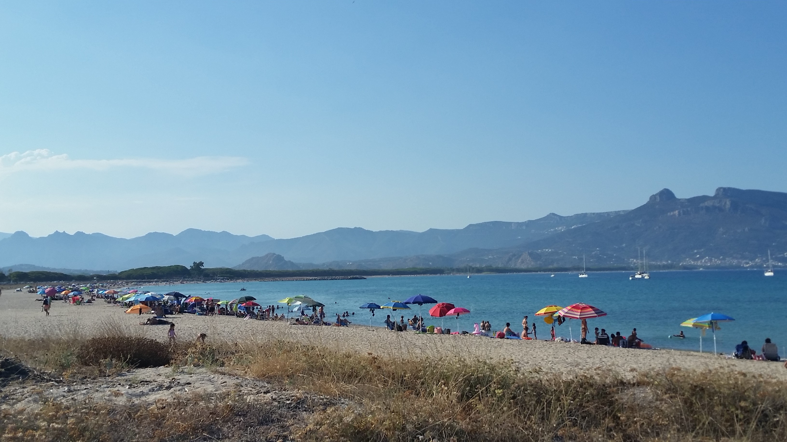
Spiaggia di Ponente - Tortolì
It overlooks the Gulf of Arbatax, not far from the Rocce Rosse (Red Rocks), in front of an extraordinarily clear sea with glimmering reflections, surrounded by captivating landscapes. The beach of Ponente (East), on the Tortolì coast, stretches from the port of Arbatax for about a kilometre and a half, up to the canal connecting the Pond of Tortolì and the sea. A pine forest runs alongside the entire length of the beach and separates it from the Baccàsara canal behind it and parallel to it.
The beach is divided into two parts by an outlet of the canal to the sea: the part adjacent to the port is smaller, crescent-shaped, with very light sand and is also known as the ‘Riva di Ponente’ (Eastern Shore); the sand takes on a distinctive ochre colour and is mixed with pebbles and shells in the wider part, the stretch known as La Capannina. The glimmering colours of the sea range from green to turquoise, with a sandy seabed. For several consecutive years, the Bandiera Blu (Blue Flag) has flown here and is prestigious recognition awarded by the FEE (Foundation for Environmental Education) to beaches that stand out for the clearness of their waters, environmental protection and sustainability and the quality of the services offered.
From the tourist port, to the right of the beach, you can set off on an excursion to explore the wonders of the Gulf of Orosei, from Cala Goloritzè to Cala Luna, while to the left you will spot the Islet of Ogliastra, which is really a small archipelago made up of granite rocks and red porphyry.
The Pond of Tortolì is a must for birdwatching enthusiasts. Its surface area of 290 hectares is a permanent home to ducks, cormorants, western marsh harriers, seagulls and egrets. In winter it is not uncommon to admire the peregrine falcon too, while s’Isuledda, an artificial island contained within it, is the habitat of a colony of grey herons. Thanks to the numerous tributaries, the pond, lush with reeds, is considered one of the richest fish basins in Sardinia.
The opposite side of the port features one of the most captivating natural monuments of Ogliastra, the Rocce Rosse (Red Rocks), porphyry cliffs emerging from the emerald green sea, next to white granite rocks. Beyond the northern canal that connects the sea and the pond, you can enter the territory of Lotzorai. The beach is called s’Isula Manna, with characteristics similar to the beach of Ponente: a canal and pine forest behind it, a glimmering sea, whitish sand with hints of gold.

Torre Argentina
The SP 49 provincial road, that connects Bosa to Alghero, is one of the most captivating scenic roads in Sardinia. It is characterised by multicoloured landscapes, intense fragrances and a feeling of freedom in close contact with nature, interrupted only by a few isolated shepherds’ huts. Along the road, about seven kilometres from Bosa, an irresistible scenario appears as you look towards the sea: it is the promontory of Torre Argentina, where a fortress guarding the territory has been standing for over five centuries. At its foot, there is a succession of coves, framed by white limestone cliffs and dotted with basalt rocks and flat rocks, with an almost lunar appearance. The sea that opens up before it is of an intense cobalt blue.
Fifty metres from the shore, a rocky islet emerges, known as the island de sas crabas (of the goats). The landscape behind it is made up of expanses of Mediterranean scrub alternating with green meadows. The tower was built for defensive purposes during the last decades of the 16th century. Inside it, there was a small garrison and light weaponry and it allowed constant visual contact with the Tower of Bosa and, further south, with that of Columbargia. At sunset, its dark solitary profile, in contrast with the warm, bright colours of the sun, will treat you to an intense emotion.
From the tower, you can follow various trekking trails along the coast, surrounded by rosemary, myrtle, rockrose and helichrysum. Towards the south you will come to the cove of Cala sa Codulera, a pebble beach washed by the sea’s transparent, shallow waters, ideal for snorkelling. Moving beyond, there is a large bay where you will find the little beach of Compoltitu, with sand and limestone cliffs tinged with white. Once again on the scenic road, just over ten kilometres north of Torre Argentina, you will enter the heart of the ‘costa dei grifoni’ (coast of the griffons), a coastal stretch that has become the kingdom of this rare bird of prey. The bio-marine park of Capo Marargiu stretches across this area: along with the griffons, golden eagles and peregrine falcons nest here. At the foot of the promontory, the seabed is just as good in terms of its rich and varied marine life. Lobsters, groupers, conger eels, skates and white breams appear amid the marine grottoes and ravines. The most distinctive touch of colour is given by the corals. Before going back to the asphalt of the provincial road, it’s impossible not to take another look at the scenery: to the right, there is Capo Caccia and there are several rocky islets in the open sea, among which sa Pagliosa, while to the south, there are the white trachyte cliffs of the Bosa coastal road.
Torre Salinas
White cliffs, long stretches of white sand, dunes covered in Mediterranean greenery, crystal clear seas and ponds full of ‘life’. The Muravera coast is a succession of beautiful scenarios, never the same yet perfectly in tune with each other. About six kilometres from the main town in the Sarrabus area, a promontory overlooking the sea offers spectacular views of the entire nearby coast and ‘embraces’ Torre delle Saline. At first glance, the ancient fortress reveals an unusual feature: it is the only one belonging to Sardinia’s coastal defence system to have a square layout. At its base, the beach of Torre Salinas stretches to the north and obviously gets its name from the building dating back to the Spanish era. The beach is very broad, reaching a hundred metres in width in some places, and it is characterised by the ochre-golden colour of the sand. Sea lilies pop up on the dunes behind it and even further back there is thick Mediterranean scrub. The sea will surprise you with its crystal-clear waters and various shades of colour: blue alternating with green tones. The beach is never excessively crowded, thanks to its size, and it has convenient parking and refreshment areas, with the possibility of renting deckchairs and beach umbrellas.
The access road to the coast runs alongside the Saline pool behind it, one of the wetlands making up the Pools of Sarrabus complex. Birdwatching enthusiasts gather here, to observe numerous bird species: great egret and purple heron, black-winged stilt, osprey, mallard, kestrel, buzzard, Barbary partridge and, above all, the pink flamingo. A path that climbs the promontory to the right of the beach will take you to the fortress, built on three levels, probably around the mid-17th century, to protect the salt marshes and surrounding territory and to act as a lookout for the barbarian incursions that plagued the coast. The building was in visual connection with the towers of Dieci Cavalli and Capo Ferrato and underwent renovation- with the plastering of the external walls - at the beginning of the 2000s. From the tower, an enchanting landscape will open up before your eyes, with the lagoons surrounded by greenery, the elevations of the Nieddu Mannu plateau in the background and two spectacular stretches of golden sand on the sides of the promontory. To the north, the coast blends into the beach of San Giovanni and continues to the mouth of the Flumendosa. To the south, the small stretch called Cristolaxeddu makes way for the magical ‘bronze’ scenery of Colostrai and Feraxi.

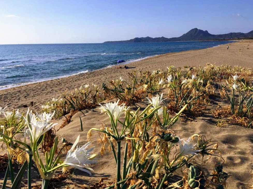
Oasis of Seu
In about one hundred hectares, it contains the most typical environmental and naturalistic aspects of the Sinis peninsula. The oasis of Seu reveals an expanse of Mediterranean scrub that stretches as far as the cliff overlooking the sea, covering the northern promontory of the cove of San Giovanni di Sinis, delimited on the opposite side by Capo San Marco. Returning to the territory of Cabras, the Tower of Sevo dominates the landscape and, in the Sardinian language of Campidano, it is called Turr’e Seu, which is what gave the name to the naturalistic area, in turn included in the protected marine area of the Sinis peninsula, and to the little beach nearby.
The oasis owes its conservation to the will of the landowners, who gained possession of it at the beginning of the 20th century, turning it into a game reserve. The area then became a wildlife oasis managed by the WWF, maintaining its wild and uncontaminated features that still make it stand out today. You will walk among myrtles, lentisks, rosemary bushes, palm trees and dwarf junipers, rockroses, broom plants and orchids. There is also a grove of Aleppo pines, while in the sandy stretches at the foot of the cliff, there are dunes covered with sea lilies. Partridges, hoopoes, larks and birds of prey such as buzzards and lesser kestrels find shelter in the greenery. Cormorants, Audouin's gulls and sea swallows circle the rocks, while it is not uncommon to see tortoises, foxes and wild rabbits between the dunes.
Almost cliff-side overlooking the sea, stands Tower of Sevo, a fortress built by the Spanish Crown in the late 16th century. Its shape is that of a truncated cone. The diameter of its base is over seven metres and it is almost ten metres high. The entrance is about four metres above the ground and it leads to a domed vaulted room. On the left, a staircase climbs up to the terrace with a parapet where the cannons were positioned. From the tower, you can admire a breathtaking view, especially at sunset: on your right there is the coastal road with the three ‘jewels’ of the Sinis peninsula: Maimoni, is Arutas and Mari Ermi are characterised by coloured quartz grains. Looking to the left, you can follow the coastline that ends at Capo San Marco. The little beach of Seu lies in a bay just east of the tower and has light sand with hints of amber and a few pebbles. The sea is crystal clear with shades of blue, turquoise and emerald green, with shallow waters and a sandy seabed. On the opposite side of the promontory, the beach of Caogheddas appears. It is larger and has two distinctive traits: an islet that emerges in front of it and the wreck of a steam boat, partly beached and partly submerged, about a hundred metres from the coast. Thanks to the fish that populate the remains of the boat, the submerged wreck is a popular destination for numerous snorkelling enthusiasts.
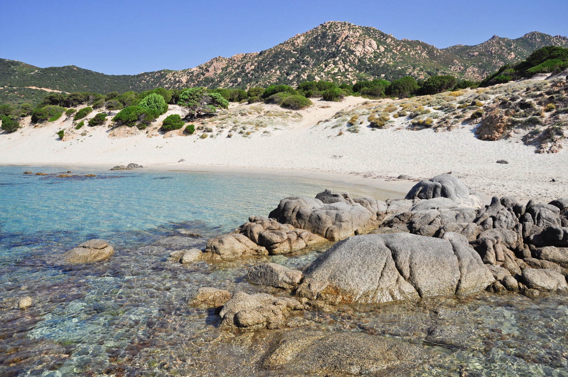
Porto Sa Ruxi
Looking at it from above, you will immediately notice its unusual three-arched form: in reality, more than a single beach, it is a group of three little coves with crescent-shaped outlines, separated from each other by flat granite rocks. However, its appearance is not the only feature that makes Porto sa Ruxi captivating: the beach is surrounded by wild nature on the outskirts of Villasimius, in a setting of cliffs and rock faces. Behind it, there are sand dunes covered with age-old junipers, maritime pines and fragrant myrtle bushes, which you can admire as you walk along the path connecting the car parks and the coast. The sand is soft and white, while the sea will surprise you with its transparent waters reflecting shades of bright blue and turquoise. The shallow waters and the shelter from the northwesterly wind offered by the hills behind it make the beach suitable for families and children. Furthermore, it is a destination particularly popular with snorkelling and diving enthusiasts: its waters, included in the protected marine area of Capo Carbonara, are rich in fish fauna populating the area around the rocks in particular.
In Porto sa Ruxi, there are refreshment areas and beach equipment and boat rental services, as well as a car park a few dozen metres from the beach. You can reach it by following provincial road SP 17 towards Villasimius, after passing the seaside village of Solanas – which falls within the territory of Sinnai - and Capo Boi, taking the exit indicated and travelling along a short stretch of dirt road. You will already see the intense colour of the sea and the charm of the cliffs surrounded by Mediterranean scrub from the coastal road that, further on - after passing a small village with the same name as the beach - proceeds along the coastline, allowing access to other wild coves, among which Cala Piscareddus, two hundred metres of light sand and rocky outcrops in front of a sea of emerald green reflections.
Continuing in an easterly direction, you will see the ‘gems’ of the Villasimius coast appearing one after another: Campus, near the mouth of a small river, is a wide expanse of soft white sand. Then there is the beach of Campulongu, surrounded by thick vegetation; next to the tourist port, and the beach of Riso, with its characteristic rice-like ‘grains’ of quartz sand. Beyond the promontory of Capo Carbonara, the unmissable destinations are called Porto Giunco, Cala Caterina, Simius and Punta Molentis.
Nereo's Cave
Below the limestone promontory of Capo Caccia, at a depth of between 15 and 30 metres, there is a hidden underwater world, with a unique charm. Nereo’s Cave is the largest underwater marine cave in the Mediterranean and in all of Europe, with a 300-metre-long main tunnel and a series of secondary chambers that allows it to reach a total of half a kilometre in length. The cave is part of the protected marine area of Capo Caccia – Isola Piana, a ‘treasure trove’ of biodiversity, also included in the Park of Porto Conte, in the territory of Alghero. The park is a natural oasis of inestimable value due to the wildlife within it, as well as the breathtaking landscapes.
Nereo’s Cave has three main entrances, one at Punta dell'Asino, that leads to the front cave, which is the ‘accessible’ part, even for divers who are not highly specialised in speleology but do have some familiarity. Thanks to the light that penetrates from the outside, you will be enchanted by the lively colours of the underwater ‘room’: the vault is populated by yellow cluster anemones, sponges, Reteporella grimaldii and a few branches of coral, while the seabed is mainly rocky and rich in white limestone pebbles. You will be able to observe groupers, sea bream, scorpion fish and red mullet as they pass by. There is no shortage of crustaceans, especially spiny lobsters, red lobsters and crabs. Moving on, red coral becomes the absolute protagonist and sea fans of various colours also appear.
The play of light created by the angle of the sun’s rays and the exposure of the various rooms of the cave attract plenty of videomakers and nature and underwater photography enthusiasts, while the more expert divers are constantly looking for tunnels, ravines and passageways that are still somewhat unexplored. The area around Nereo's Cave is not reserved exclusively for deep-diving and it is in fact possible to combine the water activity of snorkelling with trekking on the land, between vertical walls and canyons. From the top of Capo Caccia, you can admire spectacular cliffs covered with Mediterranean scrub, populated by rare birds of prey. On the opposite side of the promontory, another karst cavity holds a priceless natural and paleontological heritage: it is the Grotta Verde (Green Cave), which can be visited with prior authorisation and owes its name to a small lake with green reflections of light. It contains colonial Scleractinia - the origin of the coral reefs - and limestone rocks dating back to 200 million years ago. Moving north, itineraries that combine nature and archaeology alternate with each other, including attractions such as the forest of Le Prigionette, where the white donkeys and small horses of Giara live, and the Nuragic and Roman complexes of Palmavera and Sant’Imbenia.

Torre dei Dieci Cavalli
From an architectural point of view, it is one of the most beautiful coastal towers on the Island and it is certainly the one with the most original shape: to fulfil the purpose of protecting what was then a ‘gateway’ to the town of Muravera, it was not built next to it, but literally over it. It is no coincidence that the tower of the Dieci Cavalli (Ten Horses) is also known as the ‘tower of the gateway’. The building is located in the locality of San Giovanni, in a place that was an obligatory passage, in ancient times, along the ‘royal road’ leading to Muravera and the villages of the Sarrabus hinterland, coming from the southern coast, because along the sides there were - and still are in part - ponds and marshy areas that are difficult to cross.
The year of construction is not known, but in 1581 the tower was already operational, functioning as a watchtower and for light defence. It owes its name to the fact that it was constantly manned by a force of ten mounted guards, ready to gallop to raise the alarm in nearby villages if pirate ships were spotted. In fact, the barbaric raids constituted a devastating scourge in the Sarrabus region between the 16th and 18th centuries. The fortification consists of three building elements. The first is the doorway itself, nine metres wide, six metres high and five metres deep. The two sides of the doorway have arches of different shapes: pointed arches on the side facing Muravera, while the side facing south, which is where the attackers came from, has a depressed arch and a narrowing, with jambs and slabs embedded in the ground. The door serves as a base for the tower, which is about seven metres high and with a circular form. The diameter is aligned with that of the door. Access was from a door located to the west, via a staircase that was then pulled inside. The remains of a curtain wall are the third architectural element and are visible on the west side of the tower. Along the wall, you will see a series of embrasures used by the guards.
The sea is a few hundred metres away. In front of the tower, the long, narrow beach of San Giovanni opens up. Thanks to its size, it is never too crowded and features soft, light sand, eucalyptus trees close to the beach - under which you will find some shade in the hottest hours of the day - and the crystal-clear sea with hints of emerald green. Next to it there is parking, as well as refreshment areas and beach equipment rentals. About 800 metres north of the tower, stands the building that gave the town its name: the little country church of San Giovanni. Its origin is probably Byzantine and it was abandoned and renovated several times, with the last renovation taking place in 2005. Its stone structure, with a longitudinal form, a wooden architrave and sloping roof, is surrounded by greenery.
Turri - Sant'Antioco
It is divided into three inlets, all with different shapes, washed by an enchanting sea and a watchtower up above. The beach of Turri is located in the southeastern corner of Sant’Antioco, the largest island of the Sulcis archipelago, 15 kilometres from the town of the same name: its landscape makes it a destination not to be missed during a tour of the beaches of Sant’Antioco.
On the slopes of Capo su Moru – meaning ‘the Moor’, symbolising the fact that it was a landing place for the Saracen pirates -, you will find the first of the three coves on the eastern side. It is a few dozen metres long, crescent-shaped and protected by two high cliffs. Its golden sand is mixed with small pebbles. On the opposite side, there is a strip of light-coloured sand, mixed with dark pebbles smoothed by the sea. Further west, you will find the third, and the widest, stretch of coastline with larger pebbles and a transparent sea that, along with its turquoise and cobalt blue colour, also has hints of emerald green from the reflection of the sun’s rays on the dense Mediterranean scrub that spreads here to the point of almost overhanging the sea. Turri is a destination loved by snorkelling enthusiasts, thanks to the transparent waters of the seafloor and the wealth of fish fauna, and by surfers, especially when the south-westerly “libeccio” and the westerly “ponente” winds blow.
A short path will lead you to the top of su Moru, where the tower of Cannai stands. The fortress was built in 1757, immediately after the Torre di Calasetta, to remedy the fact that during the Spanish domination the two islands of Sant'Antioco and San Pietro had not been equipped with sighting facilities. The truncated cone tower has a circular room inside it with a flight of stone steps leading to the parade ground, where artillery and a sentry box were located. From here, it was possible to monitor the gulf of Palmas and spot any dangers for tuna traps and salt pans. The alarm was signalled from this tower during the attempted French invasion of 1793 and, later on, for the Tunisian attacks in the early 19th century, before falling into disuse in 1867. From the promontory, you can observe the island’s cliffs and the outline of the islets of Vitello and Vacca, as well as the flight of cormorants and peregrine falcons.
To reach Turri, you will pass the beaches of Maladroxia and Coaquaddus, the two ‘jewels’ of the eastern side of Sant'Antioco. The first, where the Blue Flag flies, has fine, white sand with a few pebbles and waters reflecting shades of green and turquoise. At Coaquaddus, the sand is framed by spectacular limestone cliffs as it plunges into the blue sea.
Nuraghe Barru
It once defended the surrounding territory and it now preserves the memory of its ancient inhabitants, gradually telling the story, during the excavation campaigns, of intricate events and each time providing some pleasant surprises. From high up on a limestone elevation, the nuraghe Barru dominates the plain below, divided in half between the Municipalities of Guasila and Guamaggiore. The view from the monument extends from the two villages to the mountains of Segariu and the village of Villamar. It was built in several phases, using squared blocks of limestone marl placed in even rows. The excavation campaigns have brought to light a complex structure, made up of a central keep, facing north, and two towers positioned around a courtyard and connected by curtain walls.
The keep has an elliptical layout, typical of a proto-nuraghe, so it is likely that the central tower represents the original nucleus and that the lateral towers and the walls were built at a later time. The area so far investigated stretches for three thousand square metres, but the village may have been much larger. Along the curtain wall, you can see a system of steps and several silos, which are thought to have been used for storing agricultural products.
The nuraghe Barru is still a fascinating enigma, due to the numerous interventions - not only of extension, but also to resize the spaces -, with structural modifications, repeated design changes and renovations already carried out in ancient times, making it complicated to reconstruct its history. Adjacent to the east tower there is a small room, the use of which is still a mystery. The third tower, facing south, has a slightly smaller diameter than the other two. Inside a small room, created in the thickness of the wall, on the west side of the courtyard, there is a cistern-well, where animal and human bones, ceramic fragments and a few containers in excellent condition were found. You can access the room through an architraved entrance that opens onto the courtyard, and you will also notice a narrow staircase leading to the upper level.
The fortress took on religious functions, probably at the beginning of the Iron Age: this is shown both by the type of ceramics found in the well and the discovery of a storeroom with bronze artefacts and votive swords placed in an orderly manner and carefully sealed. To the north-east of the central body you will notice the traces of other structures, belonging to the village of huts, mostly still to be investigated. The last mystery of Barru concerns its fate: no significant quantities of materials from after the Iron Age have been found and there are no traces of destruction of the building, so the most plausible theory is that it was abandoned, for some obscure reason, and destined to be buried by sediments for thousands of years, before emerging again three thousand years later.