
Decimomannu
To the west of Cagliari, after Assemini and on the edge of the State Road 130 leading to Iglesias, along a bend in the Riu Mannu, stands Decimomannu. A large town with over eight thousand inhabitants, it has always been a strategic outpost. Hence it was not by chance that the Via Caralis – Sulcis (Sant’Antioco) passed through Decimum in Roman times. Even the toponym is clearly of Roman origins, meaning ‘ten miles from Cagliari’. The first settlements in its territory are from the Neolithic period. A Nuragic village and a necropolis where bronze Punic coins were found bear witness to subsequent eras. According to the historian Casula, the 215 BC battle between the Romans and Sardinian-Punic people occurred near Decimo, during the Second Punic War. It was concluded with an overwhelming Roman victory, whose domination left several legacies, the most relevant being a bridge over the Riu Mannu in Bingia Manna, dated between the end of the 1st century BC and the beginning of the 1st century AD. Built in square limestone blocks, it is presmed to have consisted in thirteen arches. Today, three can be seen, along with the remains of other bases. Alongside are the ruins of a stone wall, an embankment for flooding. According to the Spano canon, “the bridge of Decimo was much nicer than that of Porto Torres”, with those of Sant’Antioco and Gavoi being the only Sardinian constructions still standing. Remains of another minor bridge are in the area of Su Meriagu. Other Roman remnants are those of the aqueduct, evidence of the first public water supply. In the Middle Ages, the village passed to the Giudicato of Cagliari, with many of the Giudicato residing there. From the Aragonese period, there is the sarcophagus of Violante Carroz, daughter of Giacomo, viceroy of Sardinia, held safe in the village cemetery.
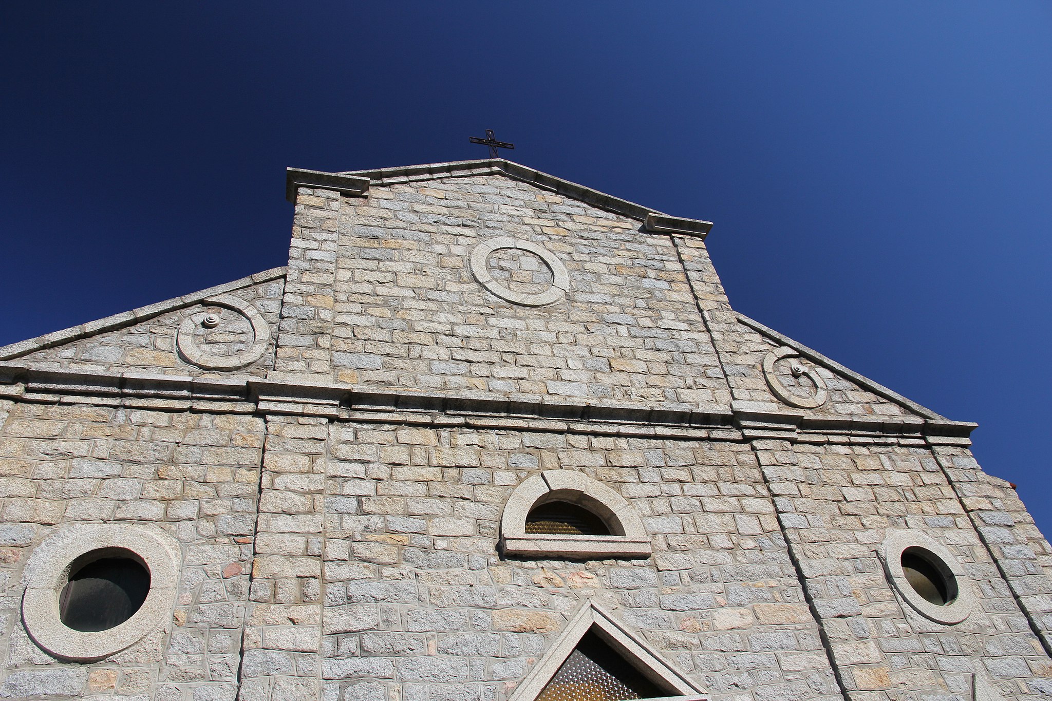
The most important religious building is the parish church of Sant’Antonio Abate in Gothic-Catalan style, dating back to the 16th century. With a single nave, there are three chapels on each side, a cross vaulting on the right side and barrel vaulting covering the left. Access to the presbytery is via a majestic arch with a starry vault. Of great importance are the Gothic capitals and the baptismal font. The façade is embellished with a Gothic portal, a rose window and – as of 1922 – a triangular tympanum. To the left stands the high bell tower.
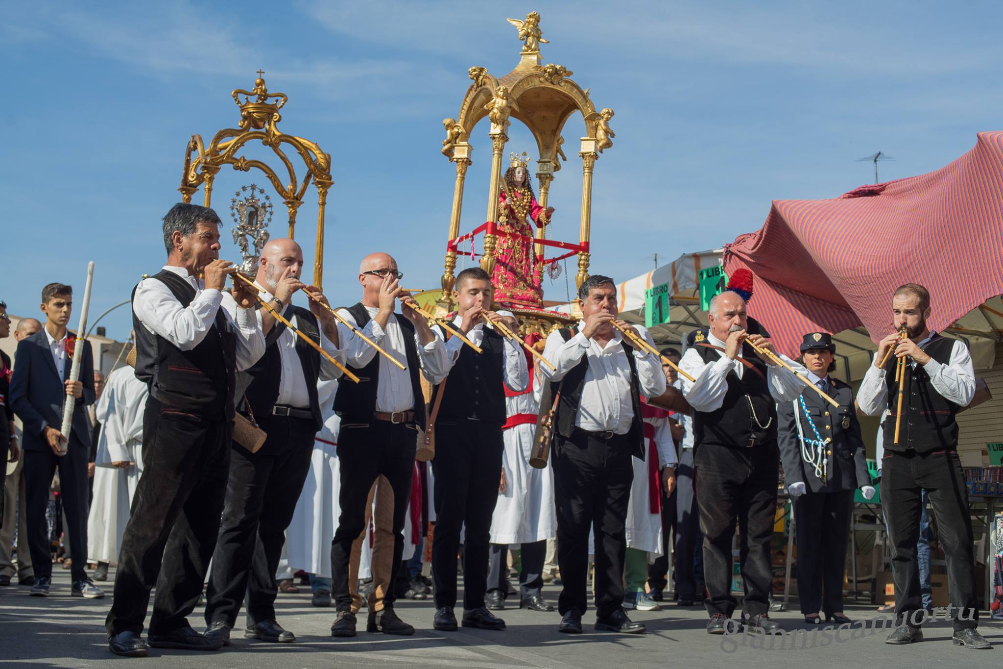
Sant’Arega (Santa Greca) has been recognised and venerated for 1700 years in Decimo and throughout Sardinia. According to tradition, the plaque, considered to be authentic (4th or 5th century), preserves a relic found in 1633. She died a martyr at twenty years of age, perhaps during the persecutions of Diocletian and Maximian (304 AD). There is information on a church dedicated to her in 1500, built on an older one (perhaps from the 13th century). In 1777, a new church was constructed at the southwest entrance of Decimo, with an altar and a pulpit in polychrome marble. It has undergone various changes and a complete restoration. The church remains isolated throughout the year, coming to life for a week in early October on the occasion of the feast in her honour that attracts thousands of people from all over the island.

Valle nuragica di Truculu
Embellishing the Valle di Truculu are two almost-identical nuraghe megalithic edifices that date back around 3,500 years – the Orruttu and Sanu that rise up majestically, two kilometres from each other. Perhaps, together with a settlement and two megalithic tombs, they constituted a fortified palace on the Osini plateau, in the centre of Ogliastra, also renowned for the imposing and beautiful complex of the Serbissi nuraghe. Departing from the village, one reaches the valley passing the Scala di San Giorgio, a narrow passage dominated by the Castello, a rocky peak that was perhaps once a fortified Roman-Byzantine residence. After the ridge, about four kilometres from the village, is a lush green area replete with remnants from the Nuragic civilisation.
At the heart of the valley stands the Orruttu nuraghe. The structure is a lone tower, covered with a tholos (a faux dome) and comprised of large, well-squared blocks of limestone. At its base, the diameter reaches 12 metres, whilst the remaining height today reaches four and a half metres. A trapezoidal-shaped entrance leads to an internal room, where there are two niches and a staircase. Completing the scene are the remains of a circular hut with a rectangular atrium next to the tower. The massive structure was frequented from the middle of the Bronze Age to more recent times (1600-900 BC).
Towards the end of the valley, the Sanu nuraghe rises up, the ‘giant’ of the archaeological area. The layout is identical: a lone tower with a vaulted tholos chamber, which today reaches six metres and has a diameter of twelve and a half metres. It is practically the ‘twin’ of the Orruttu. To be admired is the curated walling work, comprised of well-hewn blocks and horizontal rows. Placed at regular intervals, the blocks help to enhance the slender silhouette. Excavations revealed a niche and a staircase, as well as various bronze rings in an open circle, with a thin circular rod and pointed ends. The Sanu was also frequented throughout the same extensive period as the Orruttu, with a succession of uses. The dimensions express grandiosity and, considering the imposing diameter, both had to have originally been quite tall.
A few dozen metres from the Sanu, two Giants’ tombs can be admired. The burials, used in the Bronze Age, were frequented once more during the historical age. Their layout is that of the head of a bull, an animal deified by the Nuragic peoples. The rectangular apsidal funeral chamber intended for interment rituals is the head, the semi-circular space before it (exedra) are the horns. In Tomb A, part of the exedra can be seen. On the right-hand side, there are five slabs affixed to the ground, a single large block on the left side, which serves as a jamb for the entrance. The rectangular chamber is almost ten metres in length and less than one metre wide. In Tomb B, the exedra is represented by three blocks on the left side and four on the right.
Nostra Signora di Luogosanto
Legend has it that the Virgin Mary appeared before two monks, showing them where to find the relics of Saints Nicholas and Trano and suggesting that a sanctuary be created in her honour amongst the granite and oaks of Cape Soprano, where Locus Santus would subsequently emerge. Legend has it that the Chiesa della Natività della Beata Vergine Maria, known as Our Lady of Luogosanto, was built around 1218 by the Franciscans who arrived in Gallura at the beginning of the XIII century, building one of the first monasteries here during the lifetime of Saint Francis. In 1227, a few years after its completion, Pope Honorius III granted the church the title of Minor Basilica (the first church in Gallura to receive this honour). In the same year, in the countryside where the relics of the protagonist Saints were found, the Hermitage of San Trano sanctuary was constructed. The basilica was rebuilt in the 18th century, at which point it was granted the honour of a Holy Door. Having been walled-up previously, from the 1970s it was represented by a bronze door, the work of the sculptor Luca Luchetti. Presently, it is opened by the bishop for 12 months once every seven years.
La Nostra Signora di Luogosanto, constructed in square granite ashlars, has Romanesque forms. It has maintained the original 13th-century structure with three naves, having been expanded in 1912 to incorporate a portico that was originally detached. The interior is characterised by a beautiful 18th-century wooden Madonna statue known as the Regina di Gallura. Even the statue is shrouded in legend, said to have been found on a beach in Arzachena. Highly revered, it is the symbol of Luogosanto, a village comprised of narrow alleys and granite houses, with the locals being particularly devout. 22 sanctuaries are housed within, throughout the village and the countryside. Not to be missed are that of San Quirico, San Leonardo and the village of Santo Stefano, having been declared a ‘Marian city’ as of 2008. Inside the Basilica are other works of art, including the frescoes of the Baptism of Jesus and the Saints Nicholas and Trano, the statues of the Virgin Mary of Sorrows and of Saint Anthony the Abbot, and a characteristic crucifix. The village is a pilgrim destination, particularly in May, June and on 8th September, when the nativity of the patron saint is celebrated with a great festival. During the period in which the Holy Door is open, the services are particularly solemn.
The foundation of the village dates back to the arrival of the Franciscans. The historic convent, having been restructured, houses the Museum of the Natività Beata Vergine Maria, a hub for documenting the Middle Ages in Gallura, which traces the historical-religious events and displays the ex-voto donated over the centuries to the Holy Child Mary. The Agnana museum, rather, displays the history of the stazzi, typical rural settlements. Interesting historical buildings close to the churches are Palazzo di Baldu and the Castello di Balaiana
Basilica di Santa Croce
This temple is a symbol of the religious and socio-cultural integration of the Castello, the fulcrum of Cagliari, from the 13th and 19th centuries. The Basilica di Santa Croce can be explored whilst strolling through the heart of the city, upon entering into the medieval quarter from the Saint Remy bastion. After crossing the Torre dell’Elefante and going along the Santa Croce bastion in the direction of the Ghetto degli Ebrei, a stretch of a small piazza can be spied, preceded by a few steps and enclosed by the houses of the former Jewish quarter. Here, one faces the monumental façade of the basilica, which was reopened for worship in 2007 after decades of restoration. It is difficult to photograph the entire slender façade, given that one can only take a limited number of steps backward within the churchyard. The feeling of majesty increases once inside, with a single nave that is barrel vaulted and decorated with faux ceiling coffers by Ludovico Crespi.
There are three chapels on each side, also barrel-vaulted, decorated with baroque altars in polychrome marble, with sculptures and paintings from the 17th and 18th centuries. The presbytery is enriched by a high altar, guarded over by a wooden Crucified Christ, and closed by a semi-circular apse, on which Antonio frescoed the Saints Mauritius and Lazarus (1842). The façade is divided into two levels, with the lower one opening the portal, surmounted by a curved tympanum, and the upper one being distinguished by pilasters and bordered by two obelisks. Another peculiarity is the two bell towers. One is parallel to the façade, the other is near the presbytery, with a square-barrelled tower and an oriental dome. The history of the church, originally having been a synagogue, is intrinsically linked to the village, once the Giudaria of Cagliari, which reached its maximum expansion under Aragonese rule, before Ferdinand II banished from the territories of the Crown any Jewish and Muslim people who did not convert to Christianity (1492). The synagogue became a Catholic church and was granted to an archconfraternity, whose noble members were committed to comforting those condemned to death. In 1564, Archbishop Parragues, in order to promote cultural growth in the city, called upon the Jesuits, who were granted the church and adjacent houses, which became the College of the Company of Jesus. Thanks to the legacy left to them by the noblewoman Anna Brondo, the building was expanded and radically transformed. An inscription on the façade shows that the works were completed in 1661. At the end of the 18th century, Pope Clement XIV suppressed the Jesuits and the complex passed to the State. Finally, at the beginning of the 19th century, King Vittorio Emanuele I promoted the church to the rank of Masterful Basilica and entrusted it to the knightly order of the Saints Mauritius and Lazarus, to whom it still belongs. Throughout the centuries, the former college rather became the Monte di Pietà, a printing house, a Court, Court of Appeal, Faculty of Literature and, today, of Architecture.
Dolmen di Luras
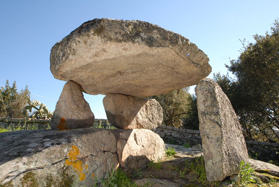
Sepulturas de Zigantes or de paladinos, as the inhabitants of Luras called the dolmen (from the Breton tol-men, being stone table), the funerary monuments built as of the late Neolithic period (3500-2700 BC), are found in greater concentration in these areas than anywhere else on the island. Here there are four of the 78 in total in Sardinia, located within the town or in its immediate vicinity. There is the allée couverte di Ladas and the simple-structured dolmen of Alzoledda, Ciuledda and Billella. Made according to a trilithic system – horizontal slabs supported by other vertical ones – they served the function of collective burials and, together, of a place of worship, compared with similar examples of Basque, Catalan, French, Corsican and Menorca origin.
Set in a splendid natural setting, the allèe couverte di Ladas consists of a gallery extending six metres in length and more than two metres in height, covered by two large slabs and equipped with an apse. The backing stone has a surface of 15 square metres that has been worked and polished. The walls are formed of regular vertical slabs, flanked by flat masses arranged in obliquely. Next to this is the Dolmen di Ciuledda, similar to that of Ladas but with a semi-circular layout and with reduced dimensions, being less than a metre in height. Found in the two sepulchres were ceramic fragments attributed to the 3rd millennium BC. Both sites are located on granite bases, from which one’s gaze rises up to the massif of Limbara. The simple structure of the Dolmen di Alzoledda rises within the inhabited area, its rectangular form with a trapezoidal chamber more than two and a half metres long and more than one and a half metres in height. The side walls are comprised of slabs surmounted by supporting stones, whilst the back wall is a single flat orthostat protruding from the walls. Amongst the vermentino and nebiolo vineyards, the dolomen di Billella rises, with a rectangular layout, at a length of two and a half metres and a height of 80 centimetres. The right wall is a rectangular slab, the left one has two worked boulders resting on the rock - one having been artificially adapted for the addition of the roof slab that is flattened on the lower surface.
These prehistoric megalithic monuments have bought great fame to Luras. To these must be added the ruins of six nuraghe from the successive age, along with other natural and cultural attractions, starting from the thousand-year-old olive trees. Amongst the trees next to the church of San Bartolomeo di Karana, on the shores of the Lago di Liscia, are two whose age is estimated to be three-four thousand years, perched amidst the twenty century-old trees of Italy. At the centre of the village is the parish church of Nostra Signora del Rosario, which houses precious paintings, and the Galluras ethnographic museum, an expression of the ancient local culture, displaying the macabre hammer used by s'Accabadora (the ‘woman of death’) in acts of euthanasia ante litteram.

Sos Enattos
A long history to be shared and to be discovered. Exploited in Antiquity, rediscovered in the mid-19th century and passing through various concessionary companies until the end of the 20th century, the Sos Enattos mine – the last Nuorese metal basin to cease operation (in 1996) – is now a ‘jewel’ of industrial archaeology and part of the Geominerario della Sardegna park, protected by UNESCO. With wells, washeries and other structures that are in a perfect state of conservation and which can be visited, the mine is immersed within the beautiful landscape, mostly untouched, of the ‘dolomitic’ chain of Mount Albo. Set amidst the woods of badgers, holm oaks, junipers and Mediterranean bush, it is the habitat of mouflon and royal eagles. Sos Enattos is part of a vast mining complex within the Lula territory, which includes two other nearby mines of galena and silver – Guzzurra and Argentaria – with the respective miners’ villages. Originally, the minerals were transported via ox carts to the Santa Lucia beach in Siniscola, then loaded onto ships.
The first signs of exploitation of the area date back to the recent Neolithic period, when the talc ‘steatite’ was extracted then worked to create artistic objects, including statues of the Mother Goddess. From the Roman era are wells and tunnels, from which those condemned to work in Metalla extracted lead and silver. The remains of the settlement were kept intact until 1960. Another ancient footprint is that of Jewish slaves of the 11th century who worked in the mines on behalf of a wealthy landowner, Nabat. As of the 19th century, excavations focused on lead-zinciferous vein and argentiferous galena, then also on sphalerite, in which the territory was very rich. The first turning point of the mine was its passing to the Societé Anonyme des Mines de Malfidano (1905). Its greatest moment of splendour came upon being taken over by the Rimisa (1951) that took the level of production to historical heights, thanks to the modernisation of old tunnels and the construction of a dam, a new washery, warehouses, a workshop, electric cabin, offices, plus housing and services for workers. In 1971, the Rolandi well was completed and the property passed to the Sardinian mining company, which tried to improve production and yields. Then came the decline, amidst strikes of the miners, who set a precedence with one of the first worker protests in Italy, as early as 1896.
Presente e futuro del sito sono rivolti alla scienza: a sos Enattos è stato inaugurato nel 2019 il laboratorio di superficie di una infrastruttura di ricerca, in vista della possibilità di ospitare l’Einstein Telescope, an che osserva e analizza le onde gravitazionali.
Present and future of the site aim to science: here, in 2019, the surface laboratory of a research centre has been inaugurated, in view of the chance that Sos Enattos could host the Einstein Telescope, an interferometer cabable of observation and analysis of gravitational waves.
Near the mine, there is also the Sanctuary of Saint Francis of Assisi, which remained dear to miners and their families. The church, built in 1795 and made famous by the Nobel Prize winner Grazia Deledda in her novels, is a pilgrimage destination for the entire island during the festivals in early May and early October. The faithful are offered on filindeu, a pasta made of super-fine strands dipped in mutton and cheese broth, one of Lula’s attractions.
MURATS
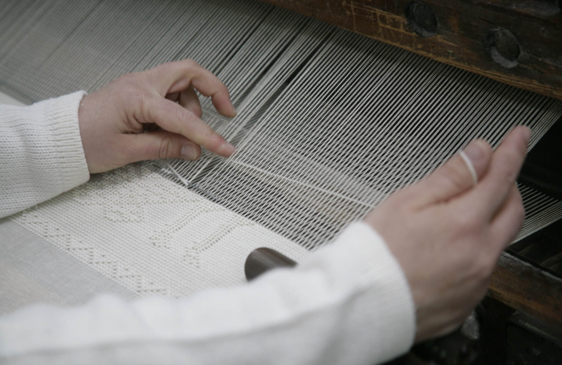
The acronym stands for Museo Unico Regionale dell’Arte Tessile Sarda - being the Regional Museum of Sardinian Textile Art – and encompasses the value and vision of an institution that, since 2002, has been safeguarding, displaying and promoting the priceless heritage of the island’s manufacturing excellence. The MURATS is located in Samugheo, a village of Mandrolisai – a territory in the ‘heart’ of Sardinia divided between the provinces of Oristano and Nuoro - renowned to this day for its flourishing textile production. The geographic ‘isolation’ of the town meant that a prolific high-quality craft tradition endured, handed down from mother to daughter.
Created thanks to the discovery of artefacts once enclosed within the settlements of the houses in Samugheo and the rest of the island, the exhibition has been set-up throughout more than 750 square metres of a building in the outskirts. It is divided into three rooms, two being on the ground floor where the permanent collection is displayed, and one on the first floor dedicated to temporary exhibitions, which enhance the variety, value and even modernity of the textile art. The permanent collection consists in a body of artefacts in wool, cotton and linen, coming from various parts of the regional territory and created throughout a period of time spanning from the end of the 18th to the second half of the 20th century. The famous Cocco collection is also included. To be admired are blankets, bed sheets, children’s linens and items for everyday use, blanket chest covers, saddlebags, traditional clothing, shepherd’s garments, attire worn by the locals on a daily basis and for festivals, along with the tools used to make them, especially traditional wooden frames. Amongst the most particular items are the affaciadas, tiny finely-worked tapestries that are spread out along the balconies during the corpus domini. Of note due to their rarity and prestige are five 18th-century tapinos 'e mortu (of twelve found in Sardinia), being carpets on which bodies would be placed during funeral vigils. Discovered in various areas around Sardinia (especially in Orgosolo), they are characterised by bold hues (yellow and black) and by a complex symbology of zoomorphic and anthropomorphic figures that accompanied the deceased on their final journey, discovered in fabrics associated with burials in Anatolia, Peru and Christianised Egypt.
The museum creates a dynamic link between the community, the past, present and new trends. Through exhibitions and events, a cross-section of contemporary art is offered. Accompanying these are the organised workshops, seminars, laboratories, internships and traineeships. During the visit, there will be an educational journey consisting of a weaving trial. The event of the year hosted by MURATS (and Casa Serra in the old town) is Tessingiu, the exhibition of the most anticipated handicraft art in Sardinia, together with the Fiera dell’artigianato artistico di Mogoro that ‘weave’ the strands of know-how on crafts hailing from Sardinian locations that are distant from each other yet united by a common cultural ‘thread’.
San Salvatore of Sinis
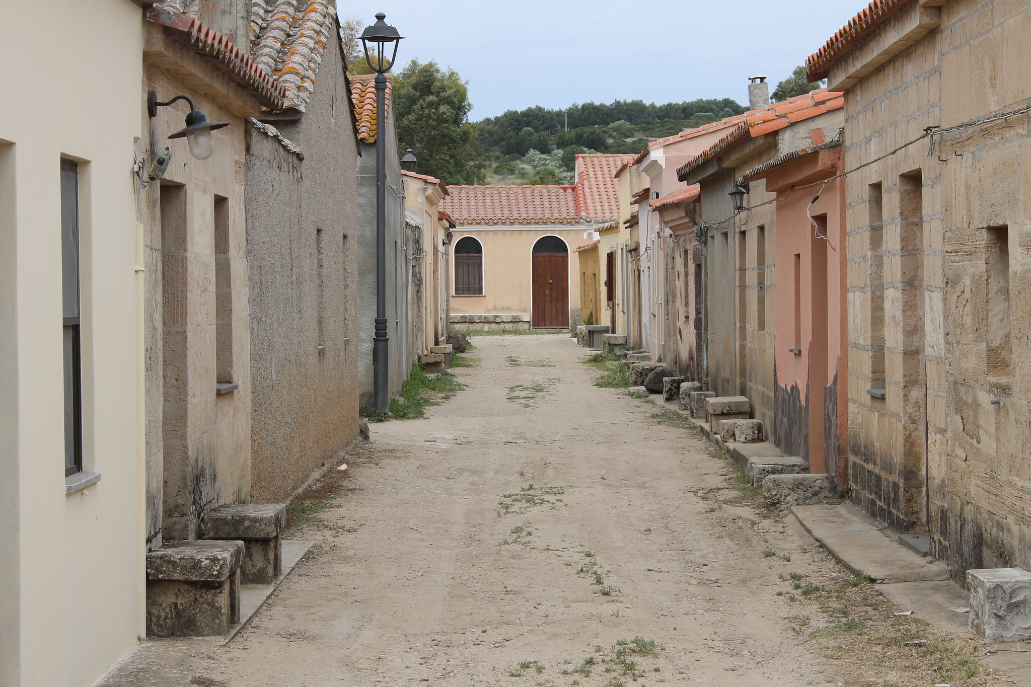
The Sardinian Far West consists in a village inhabited only a few days in September, during the Corsa degli Scalzi – a barefoot-running event. San Salvatore di Sinis, a fraction of Cabras, along a nine-kilometre stretch of road leading to the beautiful beach Is Arutas and the ancient city of Tharros, is a small village built in an area that has been sacred since the Nuragic age. It was transformed for over two decades (1967-1090), into a set for filming ‘Spaghetti Westerns’, due to the resemblance to the landscapes of the American frontier. It was thus used by film producers to become a village of Arizona or New Mexico (saloon included) in films such as ‘Garter Colt’ (1968).
A scenography in the 20th century, after having been a place of worship for thousands of years. The medieval village, whose current appearance dates back to the Spanish domain, owes its name to the Church of San Salvatore, constructed in the second half of the 17th century, built on a prehistoric sanctuary carved into the rock. Under the left aisle is a hypogeum that shows evidence of having been frequented as far back as the Neolithic period, with access via a small staircase. A series of rectangular and circular rooms (one with a well) leads to the main room with a spring source, having been used for the pagan worship of waters in the Nuragic age. Then, in the Punic era, the area was dedicated to the healer god of Sid, and in its wake, the Roman practice of the cult of Asclepius. The Romanisation of the ghost-village is completed by Domu ‘e Cubas, the ruins of baths from the imperial age with a polychrome mosaic floor, and traces of a granary (2nd century BC). From the 4th century, the hypogeum was transformed into an early Christian sanctuary in honour of the Saviour, as can be seen by two rooms with rough altars with a large Nuragic basin to the sides, reused as a holy water font. On the walls of all the rooms are Punic, Greek, Latin and Arabic inscriptions that possibly date back to attacks from Islamic marauders in the Middle Ages. Splendid early-Christian frescoes are to be admired along with graffiti and decorations that can be attributed to scenes of daily life from the Roman era and pagan cults.
The church is surrounded by sas cumbessias, small and unadorned houses built at the end of the 17th century and used as accommodation for pilgrims during the novena prayers in honour of San Salvatore, between August and September. In the twenty-year ‘cinematic period’ of the village, these were an integral part of the western scenography. The highlight of the celebrations commences at the dawn on the first Saturday of September with the Corsa degli Scalzi, one of the most evocative and heartfelt identitary events in Sardinia. The procession involves over 800 curridoris in white tunics, running barefoot along a long dirt road following the simulacrum of the saint from the Church of Santa Maria Assunta in Cabras to the township. The simulacrum is then returned to the parish church the following day.
Military fortifications of the Maddalena Archipelago
The Maddalena Archipelago is a land off the border of Sardinia’s north-east, a strategic position that has marked its destiny over the centuries. Along the road that runs along the coastal perimeter of the Maddalena, the ‘older sister’ of a good 60 islands and islets, modern history can be retraced in a place that has been the scene - in Antiquity, as well throughout the last three centuries - of epic naval battles.
In the second half of the 18th century, with the advent of the Piedmontese who made it a support base for Sardinian Navy vessels, La Maddalena, Santo Stefano and other areas of the archipelago were ‘reinforced’ by fortifications - the square tower, the San Vittorio fort, also called the Old Guard, and other forts including the Sant’Andrea, Balbiano, Sant’Agostino and Santa Teresa (also called Sant’Elmo). All are visible from the sea, to discourage pirate attacks.
Commencing in the early part of the 19th century, the defensive system was implemented with the Carlo Felice fort or ‘Camicia’, to protect the Maddalena passage of the Moneta, and with the San Giorgio fort in Santo Stefano. The structures were replaced over time. More recent are other sighting posts and fortifications arising from the late 19th century through to the world wars. More powerful batteries were constructed, occupying positions facing the sea, such as that of Nido d’Aquila and Punta Tegge in the south-western area, Punta Rossa in Caprera, and on the mainland in Punta Sardegna (Palau) and in Capo Tre Monti (Arzachena). Of strategic importance are also other Maddalena forts on high ground, such as Guardia Vecchia and Trinita, which dominates the splendid beach of the same name.
The archipelago, now a national park, hides evocative traces of battles and camouflaged amongst the rocks are anti-aircraft posts. Starting from the splendid Spalmatore cove and in another vast array of strategic locations: Carlotto, Zavagli, Zanotto, Pietrajaccio, Candeo, Cervo Mass, Poggio Baccà, Isola del Porco, Teialone and Punta dello Zucchero. All of these sites can be visited today thanks to the park guides.
Noragugume
Perching 300 metres above sea level on undulating hills, it prevails over the Ottana plain between Lago Omodeo and the Marghine range, dominated by the imposing Gennargentu massif. The Villa di Noragugume has just over 300 inhabitants, dedicated mainly to livestock, forming part of any authentic village in Italy. The name derives from a Nuraghe structure shaped like a cauldron that stood near the centre. The origins of the village are prehistoric, whilst the current town, well-structured and decorated with murals, dates back to the 15th century with the Chiesa di Santa Croce at its heart, consecrated in 1593. In addition to the modern parish of San Giacomo – the patron saint celebrated in late July – two other churches are of considerable importance. On the outskirts is the ancient country church of San Michele and in the central piazza, that of the Beata Vergine d’Itria, with a Gothic-Catalan layout (1623). The feast of Madonna d’Itria on Pentecost Tuesday is the most heartfelt in the town, accompanied by an ardia, a galloping race around the sanctuary, perhaps dating back to when the town was divided into districts and the knights who represented each one would try to conquer the standard of the Virgin. San Giovanni is at the end of June, whilst at the end of October there is s’Izzadorzu, celebrations accompanied by folklore events, poetic competitions in the Logudorese dialect and tastings of recipes from the pastoral tradition. Stewed and roast lamb are the protagonists, paired with potatoes, peas and wild fennel. The entrails of lamb or goat are prepared in dishes called cordula and trattalia. There is a wide variety of bread, from the types enjoyed on a daily basis such as su bistoccu, to those more elaborated prepared for special occasions. Each festival is accompanied by specific desserts: frisciolas, pasta violada and culinzones de mendula for carnival, casadinas with cheese and tiliccas (sapa liqueur, almonds and honey) at Easter, pabassinos (almonds, walnuts and raisins) and santos de tuccaru for All Saints.
The territory of Noragugume has been populated since Neolithic times, as is shown by the Domus de Janas of Taleri and Iscannitzu and the menhir Sa Pedra ’e Taleri, of the proto-anthropomorphic type, dating back to 3300-2500 BC, which arises isolated and imposing (four and a half metres high) in a flat area. Indeed, there are numerous Nuraghe structures, including the Irididdo with a central tower and two lateral ones, the Muresune and Litzera. The most famous is the Tolinu nuraghe, in a dominant position on a plateau two kilometres from the town. The structure, dating back to the Middle Bronze Age and remodelled in successive periods, was used through to the historical age, being complex with a well-preserved bastion and central tower. Around this, the residential settlement can be seen.