
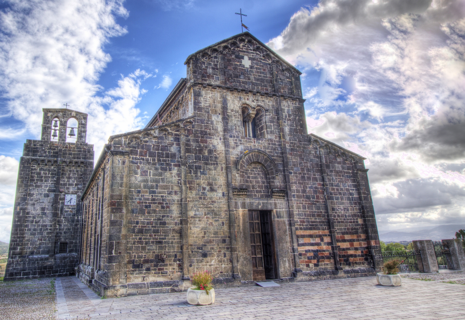
Nostra Signora del Regno
It stands with imposing darkness at the entrance to Ardara, a village in the Lugodoro region, perched on the slopes of Montesanto. The basilica of Nostra Signora del Regno is located near the ruins of a royal palace, a contemporary building that was once the place in which the Giudici (judges) of Torres resided. The Giudici would take oaths at the church altar and it was here that they were buried. It overlooks the plain below from high up on a hillock: its secluded and dominant position adds to the charm of this building made of jet-black ashlars of 'ferrous' trachyte. It was originally just a chapel: Giudice Comita (or perhaps his sister) was responsible for enlarging it in the second half of the 11th century. The expansion of the church was terminated by Pisan workers in 1107, as can be seen on a consecration inscription on the altar. An extraordinary monument was built and it is one of the most important pertaining to Romanesque architecture in Sardinia, characterized by simplicity and grandeur. It will strike you with the contrast between its black basalt stone and the gold sixteenth-century altarpiece.
An arched portal opens up on the façade, which is divided into five segments by pilasters. The bell tower stands against the northern side of the building. There are pillars along the three naves and the two lateral naves have cross vaults, while the central one has a wooden ceiling. The main Retable is in the apse: it is the story of Salvation, told by the images of prophets, patriarchs, saints and the blessed Virgin Mary. The author and date (1515) are indicated on the altar-step. Inside, you can also admire a series of eighteenth-century frescoes, depicting the twelve apostles and the four fathers of the Church, as well as the Smaller Retable, a wooden pulpit that narrates the Passion of Christ. Another valuable work of art, dating back to the early 12th century, is the processional banner: the Virgin Mary with Child is painted on one side, while the Veil of Veronica with the face of Christ is painted on the other. It is the protagonist of the celebration honouring the patron saint of Ardara, which is attended by flocks of worshippers. The celebrations culminate in a procession on 9 May, accompanied by the choir of Sos Gosos, singing praise to the Virgin Mary. Following this, there are songs, dances and folk exhibitions.
On the subject of places of worship, you can visit the nearby extraordinary Nostra Signora di Castro (12th century) and the Basilica of Sant'Antioco di Bisarcio, one of the most important Sardinian Romanesque churches. Also in the surrounding area, don't miss the castle of Monte Acuto, the Grotto of San Michele, which led to the formation of the 'Ozieri culture' (3200-2800 BC), the Nuraghe Burghidu and the Roman bridge on the Rio Mannu river.

Sanctuary of San Costantino imperatore
It is known as Santu Antinu.in the Sardinian language. The rural church of San Costantino, in the territory of Sedilo, overlooks the splendid scenery of Lake Omodeo, the largest artificial basin on the Island (for a long time also the largest in Europe). Along the perimeter of the sanctuary are the buildings used as accommodation for pilgrims, known as cumbessias or muristenes.
The year in which it was founded is unknown but there is certainty regarding San Costantino Imperatore’s very ancient origin. The current building, in Gothic Catal style, dates back to the 16th century and it underwent renovation work in the 18th century. Of the original structure, the quadrangular presbytery still remains and has a ribbed cross vault with suspended capitals sculpted at the base.
The hall, which is divided into three naves by pillars and rounded arches, has a barrel vault. The interior ends, just before the presbytery, with a pointed arch. The façade is made of exposed red trachyte and ends with a curvilinear shape. On top of the portal, there is a tympanus supported by two semi-pedestals. On the sides and inside the tympanus, you can see three niches and there is a rectangular window above. On the left side of the facade, there is a small belfry. Inside the sanctuary there are numerous ex voto offerings on display.
Around the church, at sunset on 6 July and at sunrise on 7 July, the S’Ardia takes place, a spectacular horse race in honour of the saint, commemorating the battle of Ponte Milvio between Constantine and Maxentius. It is one of the most evocative events linked to Sardinia’s identity and it attracts thousands of visitors with its charm and daredevilry. During the ritual, the sa prima pandela (capocorsa) leads the race, followed by another two horsemen and by three escorts, symbolizing Constantine and his army. Then there are a further one hundred horsemen representing the pagans led by Maxentius.
The Sanctuary and the Ardia are the symbols of the village of Sedilo that, as well as its ancestral traditions, also features ancient stone dwellings. Its territory is perfect for excursions on foot, by bike or on horseback, particularly its forests with sign-posted trails. The geological park is not to be missed and, inside it, on the banks of Lake Omodeo, there is the Nuragic Palace of Iloi (dating back to the Middle-Late Bronze Age), consisting of a trilobed Nuraghe, a village and two Tombs of Giants. Not far away, there is another important piece of Nuragic evidence: the sacred spring of Puntanarcu. Nearby, there is also the necropolis of Ispiluncas, consisting of about thirty Domus de Janas, proving that the territory was frequented in the Pre-Nuragic period.
Villa Sant'Antonio
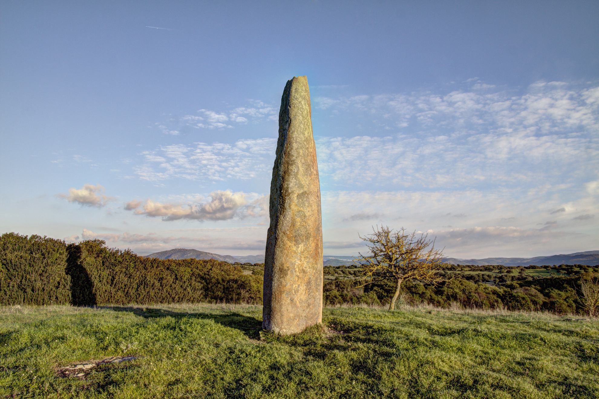
It stands on the hills and is delimited to the south by the basalt platform of Assolo, to the east by the river Imbessu, to the north by mount Grighine and to the west by Brabaxiana of Usellus. Villa Sant'Antonio is a village with just 350 inhabitants in the Alta Marmilla region, which occupies an area rich in natural attractions and rare archaeological evidence, like menhirs. The little village emerged in the early 18th century as a novenario (small rural village) around the church of Sant'Antonio abate, built to consecrate the place in which the simulacrum of the saint was discovered. It didn’t take on its current name only 1985. Agricultural and breeding activities are its main economic resources. The hilly territory, rich in springs, is covered by thick Mediterranean scrub and lush holm oaks and cork oaks. Along the Imbessu valley, there are green alders, willows and tamarisks. The territory is rich in evidence of prehistoric, protohistoric and Roman times. The first pre-Nuragic settlements left traces on the long plateau of monte Padrillonis, two kilometres from the village. Dating back to Neolithic times, there are about sixty domus de Janas: in is Forrus, there are the most ancient ‘well’ type and the more recent type with a corridor before the funeral parlour, and the same type in Genna Salixi. Other burials are located in the Maccettu (or Trunch'e Pani) site. In the territory of Villa Sant'Antonio there is an extraordinary concentration of perdas fittasi (embedded stones) or menhirs, megaliths made between 3300 and 2500 BC. They were originally big, roughly-finished boulders singly or in groups, embellishing the burial areas (and also residential settlements and places of worship). They later took on pointed forms with a flat-convex profile. In Villa Sant’Antonio there are a series of examples of these early phases, called 'proto-anthropomorphs', in Carabassa and Cardixeddu. Later on, their shape became more balanced and streamlined (anthropomorphic menhirs) and you can see some examples of these. The menhir of monte Curru Tundu is remarkable: it is almost six metres tall. Other ‘embedded stones' are located in the Tuttiricchiu area. There is no shortage of Nuragic evidence: there are ten examples, of four different types: corridor, monotower, complex nuraghi and one ‘a tancato’ nuraghe. The oldest is the nuraghe Spei, with two floors, dating back to the Late Bronze Age (1800-1500 BC). Slightly later ones include the Crannaiou and Genna sa Pira nuraghi (1500-1200 BC). The Roman age is represented by four settlements, to the north (Pranu Cilixia, sa Sedda ‘e s’aurras) and to the south of the village (Funtan Menta and on the banks of the Imbessu rivulet). The church of San Giorgio was built during the Byzantine period.

Cave of Santa Barbara
In the eyes of the miners who discovered it in 1952, during the excavation of a well, it must have seemed like an apparition. It had remained undiscovered until that point in time, hidden in the bowels of the mountain. Indeed, the Grotta di Santa Barbara is one of the oldest in the world, certainly the oldest in Italy, and a natural wonder at the heart of the San Giovanni mine, in the territory of Iglesias. After a long period of closure, visits resumed in 2016, with scheduled accesses that serve to preserve the grotto like a precious jewel it is.
The cavity consists of a large hall extending over 25 metres in height and dotted with columns of stalactites (extending from the top to bottom of the room) and beautiful stalagmites, covered with extravagant aragonite, formed over thousands of years. Another characteristic of the cave consists in the honeycomb concretions arranged along walls and vaults. At the bottom, a small, silent lake makes the surrounding walls glimmer with reflections of water. This Grotta opens up between a layer of ceroid limestone and yellow silicified dolomite, formations dating back to the early Cambrico period (about 500 million years ago). What is unique are the tabular crystals of dark brown barite covering the walls, a mineral only found in Europe.
From 1875 to 1998, lead and zinc were mined in the cave, which can be entered on a little electric train that crosses the mining tunnel (about 300 metres in length), located at an altitude of 200 metres. From the train, an elevator takes you 36 metres up the shaft before you enter Santa Barbara from a spiral staircase. The cave has no external exit points, hence why it has remained so intact.
The section of the train takes you back in time to the mining epic that characterised all of Sulcis-Iglesiente area - inside the gallery gunpowder, slow-burning fuses, detonators, hoppers, even the mineral on the walls can be seen. Next to the cave, passes the Santa Barbara mining route: a 400-kilometre long historical-religious itinerary, to be travelled on foot or by mountain bike, along ancient paths and abandoned railways, today the heritage of industrial archaeology of the Geo-mining Park of Sardinia. To further your knowledge of the mining world, you can visit the museum of mining arts and the machine museum in Iglesias or delve into the mining world through guided tours in the mines of Monteponi, San Giovanni in Domusnovas and Masua.
Madonna del Rosario
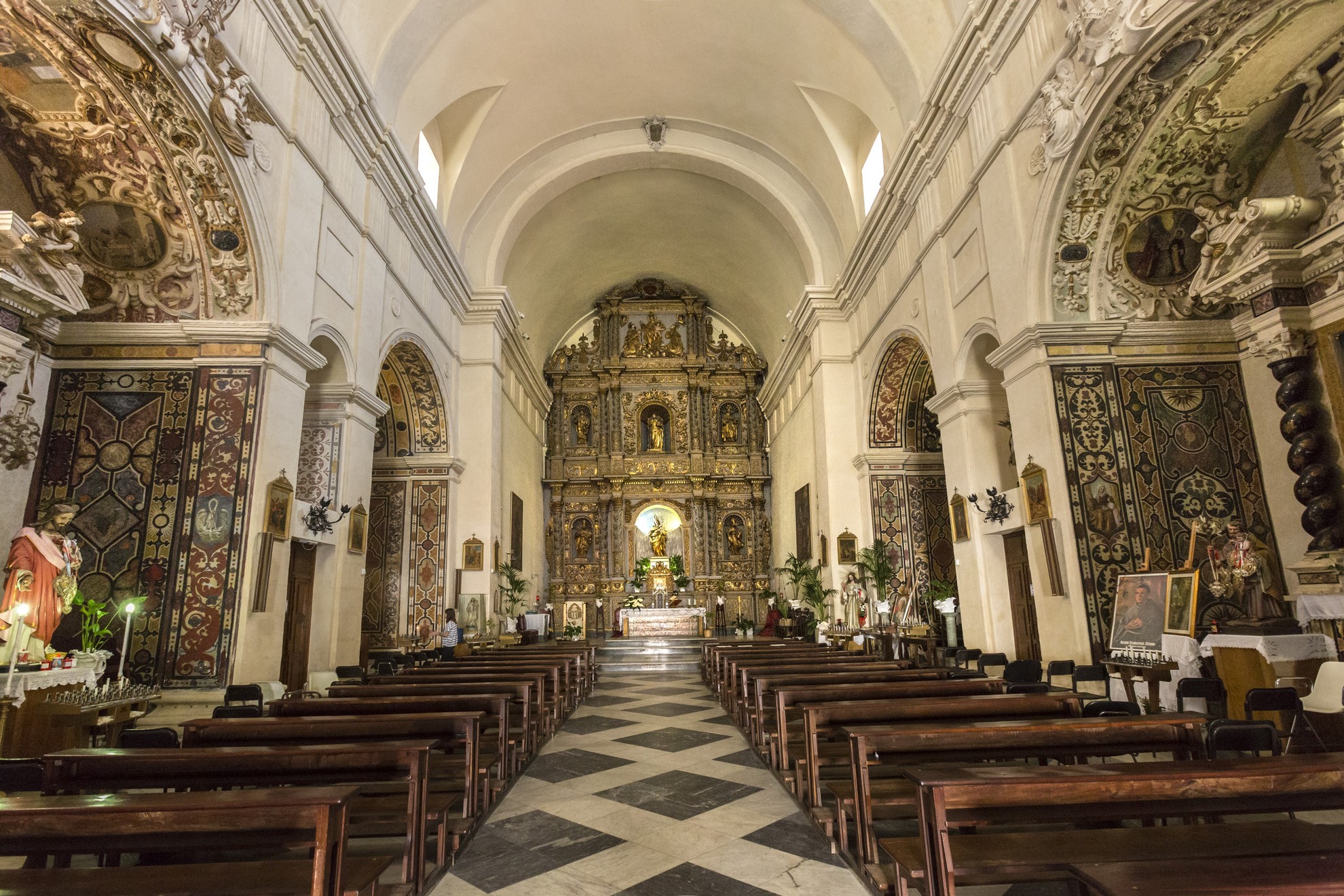
It overlooks Piazza Castello in the heart of Sassari, where once stood an opening in the walls of the medieval citadel, revealing in its architecture and furnishings a complete and splendid expression of Baroque art. It is thanks to the hard work of the Dominican monks that the first church of Madonna del Rosario was built, together with the convent, in 1635. The temple was rebuilt and enlarged twenty years later, taking on its present form. All was completed in 1759 with the façade, the work of Gavino Pirinu from Sassari, arranged into two sections. At the centre of the lower part stands a portal framed by Corinthian columns and an entablature, from the ends of which rise two volutes that simulate a curvilinear pediment. Inside, a niche houses the statue of Our Lady of the Rosary. The second segment is narrower and smoother, with a central high-arched window.
Immediately upon entering, the gaze is captured by the high altar. The entire back wall is occupied by the monumental Altarpiece of the Rosary (1682) carved in wood, polychrome and gilded, considered in terms of its size and value as one of the most important works of sacred art on the island. It is structured in three sections, the lower two including six statues inside niches and the upper fastigium.
As is customary in Sassari religious buildings from the 17th and 18th centuries, the church has a single nave divided into three bays, on which are three chapels on each side, with a barrel vault. In the background, dominated by the wooden retable, are the raised presbytery, which connects to the hall through a triumphal arch, and the apse, both with a quadrangular layout. The presbytery is covered by a barrel vault that stands on a moulded frame, decorated with adornments and a triglyph frieze, marked by double transverse arches. The side chapels are entirely decorated with motifs imitating marble inlay, a baroque decorative technique that is unusual in the Sardinian context. Inside, stone and stucco altars stand out, painted with marble effects and characterised by a great variety of ornamental motifs.
The structures and ornamentation of the Madonna del Rosario can be traced back to a project that included workers from Liguria and Lombardy undertaking a project in Sassari at the end of the 17th century. Baroque architecture and decorative solutions can also be found in the rich façade of the Duomo di San Nicola (cathedral), in various works and the decor of the church of Sant'Antonio Abate and in the furnishings of San Pietro di Silki.
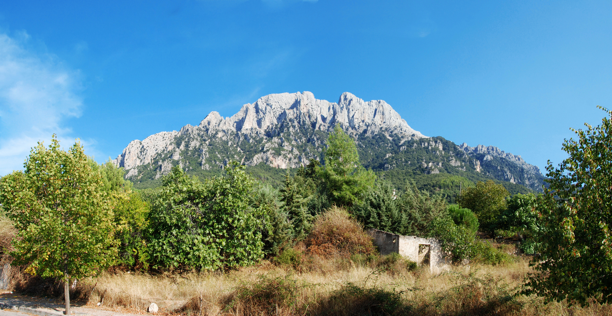
Monte Corrasi
Its appearance is characterised by sheer limestone rock faces, crags, white pinnacles, caves and large plains. It is rugged and barren at the summit, covered in holm oaks in the middle strip and is adorned by olive trees, vineyards and almonds in the lower part. Mount Corrasi is the highest peak of the vast and inaccessible plateau of the Supramonte mountain range, as well as being one of the most evocative elevations in the Island. The challenging trails that cross it and climb to an altitude of 1463 metres are destinations that expert (and in good shape) trekking enthusiasts aspire to and arrive in Oliena to climb it. From the summit of the Corrasi, you can enjoy spectacular views and a 360-degree panorama that stretches from the coastlines of the Gulf of Orosei to the Gennargentu massif. Flora and fauna complete this 'special' place with its dolomitic atmosphere: although it might seem completely arid and desolate, in reality there are 650 botanical species here, about 60 of which are native ones. It is a green paradise of the highest order, persuading the Italian botanical society to include the mountain in the census of the biotopes of greatest interest, where birds of prey like the golden eagle, the buzzard, the Eleonora's falcon and the peregrine falcon reside and where the mouflon roams freely.
In the Oliena part of the Supramonte mountain range, which features valleys, plains, sinkholes and canyons, as well as the Corrasi, you can tackle other summits: Ortu Hamminu, sos Nidos, the evocative mountaintop of Cusidore and Carabidda, at the foot of which lies the village. Something else that trekkers should not fail to do is climbing Mount Maccione and, above all, visiting the valley of Lanaittu, rich in natural and prehistoric sites: within it, you will find the village of Tiscali, the caves of sa Oche and su Bentu and the Corbeddu cave. At the entrance to the valley you will find the sacred area of sa Sedda ‘e sos Carros, important for the traces of metalworking in the Nuragic period and as evidence of the practice of the cult of the waters. A visit to the su Gologone, which has been declared a national monument, is a must. “The murmur of the surrounding forests is like that of a sea not far away; a riptide at the foot of the mountains”. This is how Elio Vittorini, in his 'Viaggio in Sardegna' (Journey to Sardinia, dated 1936) evokes the sensations generated from by Oliena, a Bandiera Arancione (Touring Club of Italy Orange Flag) municipality and one of the most distinctive villages in the Nuoro area, with an enviable position, natural beauty, cultural traditions and welcoming community. Products, like embroidery on silk scarfs and filigree jewellery, Carasau bread, rustic cuisine and Nepente, the renowned Cannonau wine revered by the poet Gabriele D'Annunzio, are just a few of the things that make it stand out.
Tempio - Altare di Monte d'Accoddi
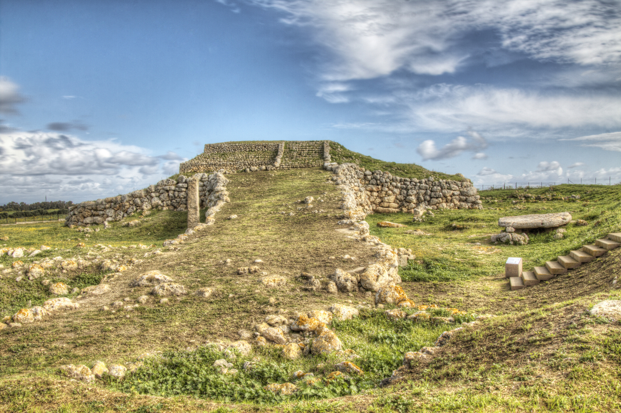
Although there is no direct relationship, it is identical to the contemporary Mesopotamian temples and embodies the ‘oriental’ creed of the union between heaven and earth - the sacred areas on top of reliefs were considered the meeting point between man and divinity. The temple of Monte d'Accoddi (from the archaic kodi, ‘stone’), dating back five thousand years, is a ziqqurat that is unique in Europe due to its singularity of architectural types. It was discovered in the mid-20th century, digging into a small hill that appeared to be ‘artificial’, rising up in the middle of a plain. In fact, it was a pyramid altar covered with earth, perhaps dedicated to a female deity, carved in a granite stele alongside the monument. According to legend, it was built by a prince-priest who had fled from the Middle East. It had one very special feature: the ziqqurat is the temple of the Sun, in turn dedicated to the Moon.
The pre-Nuragic sanctuary stands in the centre of Nurra, along the ‘old’ State Highway 131 (heading towards Porto Torres), in the territory of Sassari, eleven kilometres from the capital of the north of the island. The monument played a central role in society of the time, being the culmination of the evolution of a complex developed from the second half of the 4th millennium BC. The altar is the superimposition of two phases, that of the ‘red temple’, in the final Neolithic period (3500-2900 BC), and the following ‘terraced temple’, in the Aeneolithic period (about 2700 BC), as part of the Abealzu-Filigosa culture. In the first phase, several villages of quadrangular huts were part of a ceremonial hub, including a Domus de Janas necropolis and alongside the Santuario, in their original positions, are an elongated menhir (four and a half metres high), an enormous slab with seven holes (perhaps use to tie up victims) and boulders of spheroidal stone, one of five metres in circumference. All the stones served a specific purpose in the sacrificial rituals. At the end of the final Neolithic period, the people of the Ozieri culture built a platform in the shape of a pyramidal trunk, with sides at the base extending 27 metres, above which stood a rectangular room with surfaces plastered and painted in ochre and traces of yellow and black. Of the sacred area remain the floor and remnants of a perimeter wall. Around 2800 BC, the structure of the ‘red temple’, abandoned for about two centuries, was buried under a colossal filling of earth, stones and limestone marlstone, in turn ‘covered’ with large blocks of stone. A new large terraced pyramidal platform was built, with sides longer than the previous one and accessible from a ramp that was forty metres long and thirteen to seven metres wide. The second sanctuary is reminiscent of the ziqqurat with an ‘open-air’ altar. The structure occupies 1,600 square metres, rising up almost six metres (originally perhaps eight). Inside is an unexplored room. Perhaps, as in Mesopotamia, it contains the sacred bed where the ritual of regeneration of life and fertility of the earth was carried out. Around are the remains of a village, where ceramics were found almost intact. To be admired are finds safeguarded in the Sanna archaeological museum, along with a model of the altar in its earliest form. The building retained its religious function for a millennium. At its base, remains of sacred meals and objects used in propitiatory rituals were discovered. The site was abandoned at the beginning of the ancient Bronze Age (1800 BC) and occasionally reused for burials.
Village of sa Sedda 'e sos Carros
The name literally means 'where the carts pass', and dates back to the charcoal collection activities that characterized the site in the nineteenth and twentieth centuries: it is the location of a nuragic complex of exceptional architecture and engineering, created at the time of metalworking and linked to the cult of water, a precious element in the arid calcareous environment of the Supramonte, the Sardinian 'dolomites'. The village of sa Sedda 'e sos Carros is set in the wild valley of Lanaittu, a spectacular natural background within the territory of Oliena, accessible from the road that also leads (going towards Dorgali) to the national monument of the karst spring on Gologone and beautiful caves of sa Oche and su Bentu.
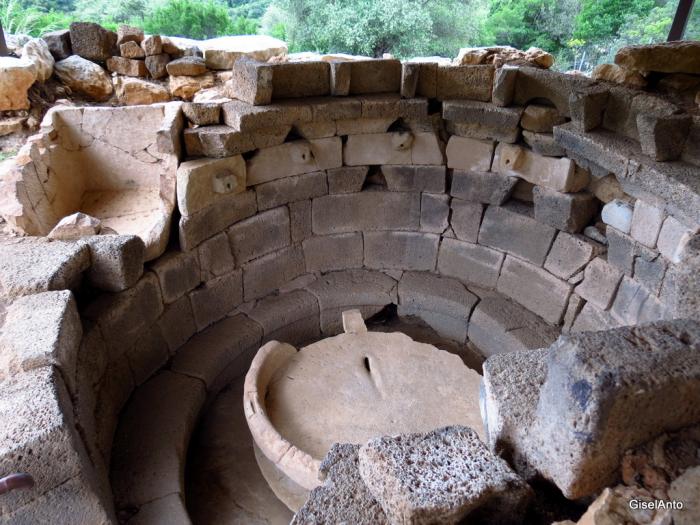
It is an insula similar to many nuragic villages in the Barbagia area, that grew up without any close nuraghes. It lies on the left side of Lanaittu, on the steep outcrops of Mount Uddè, about 300 meters above sea level. It dates back to a period between the Late Bronze and early Iron Age (12th-9th century BC) and is particularly important due to the presence of traces of metals fusion in the Nuragic age - an era in which man learned to extract and forge metals (bronze and iron), leaving behind the finds found in the numerous circular and oval huts that make up the village. One dwelling stands out for its singular architecture and ritual function: it is the 'source', a circular space with internal walls in dual-tone squared blocks - of white limestone and dark basalt - and carefully worked flooring. On the walls are carved mouflon heads in high relief with a hole through which the water, which came from the canal built into the wall thickness, gushed into the monolithic basin in the center of the floor. Near the hut you will see a large circular structure with steps: this was the pool for ceremonial ablutions, religious rites that involved the use of sacred water. This structure changed its use over time, becoming a storeroom for bronze objects waiting for a new processing cycle. It is probable that there was a casting workshop near the village.
In addition to sa Sedda 'and sos Carros, the Lanaittu valley also holds another nuragic site, the most spectacular of the island: the village of Tiscali. The green valley, which will appear sunny and solitary once you pass over passu malu (the bad pass), was inhabited long before the Nuragic age: it was a favorable environment for settlement since the Upper Palaeolithic, as shown by the remains of the Corbeddu cave.

Acquario di Cala Gonone
This is the largest and most modern structure of its kind in Sardinia. The aquarium of Cala Gonone, built in 2010 in the coastal village of Dorgali and set within a green park to symbolise the transition from the mountains of Supramonte to the sea, unites educational aspect (and environmental protection) with fun. You will be ‘immersed’ in 24 display tanks on a journey from the shore to the depths of the sea, passing rocky coasts and the open sea dominated by jellyfish, large snappers and sharks. This is a representation of the main marine habitats of the Mediterranean. You can come across the world of trumpetfish, see the camouflage capabilities of cuttlefish and octopus, dive into the dark hideouts and other spectacular environments of the Gulf of Orosei. In one of the most fascinating pools, dark rocks reproduce columnar basalt with an opening that has become a lair for eels and moray eels, whilst the lateral ‘terraces’ are home to scorpion fish. The open sea basin is the largest, divided into three sections across a number of levels - the first being naturally lit, the other two artificially illuminated to represent the kingdom of large pelagic fish, also home to sea urchins. A loggerhead sea turtle also lives here. Mediterranean and beyond: in the first pool, the only freshwater one, you will see the voracious piranhas, In the tropical seawater pools are a range of species in amazing shapes and bright colours that live in coral reefs. Tropical basins tell the story of the origin of an atoll and cases of evolutionary adaptations and symbiosis. The route ends with the tactile tub - learn to fearlessly feel a fish and touch sea urchins, starfish and hermit crabs.
After this ‘dive’ into aquarium life, the village of Cala Gonone can be explored, nestled on a steep hill that slopes down to the sea, an attraction for lovers of nature and adventure or for romantic boat trips. Relax on the golden sands of Cala Cartoe, Ziu Martine and Cala Osalla or, by the sea or on a trekking adventure, you can reach Cala Luna, the ‘pearl’ of the Mediterranean. A guided excursion will take you to the Grotte del Bue Marino, a spectacular ‘forest’ of stalactites and stalagmites, once the habitat of the monk seal, the evocative setting of the Cala Gonone Jazz festival. From the coast to the hinterland of Dorgali: cultural, food and wine traditions, archaeological attractions, including the museum housing the remnants of the Nuragic village-sanctuary of Serra Òrrios, with crafts (such as filigree jewellery and ceramics) and monuments of worship, or the churches of Madonna d’Itria and Santa Caterina. To be discovered is a natural heritage extending over 225 square kilometres, with the pride and joy of the Supramonte, the Valle del Cedrino and the Valle di Lanaittu.
Necropolis of Madau
Near the hamlet of Pratobello, about 15 kilometres from Fonni, the ‘highest’ village of the island, a Nuragic necropolis with four similar Tombs of Giants arises, standing on a plateau in the midst of the splendid Riu Madau valley, at the foot of the Corr’e Boi passage, so-called because it looks like the head of a gigantic bull. The tombs, dating back to the early or late Bronze Age and perhaps connected to the nearby Nuragic village of Gremanu, are structured around an amphitheatre and face the rising sun. Two of them are well-preserved, having been excavated and studied between 1982 and 1986 by the ‘father’ of Sardinian archaeologists, Giovanni Lilliu.
After crossing a trail at the entrance of the archaeological area, one comes across the first and oldest tomb on the right. It looks like a sarcophagus made of large granite slabs set into the ground, delimiting the burial chamber. On the slabs magical-religious motifs and cups can be seen in the depictions. One is the Stela di Madau, which presents symbols connected to the cycles of Nature or, perhaps, to the constellation of the Pleiades. The next tomb is the most monumental. Having a 22-metre long funeral chamber and a wide exedra (24 metres around), its benches-seats (for votive offerings) delimit the space for funeral ceremonies. Relatives of the dead would have gathered around the still-visible hearth in this sacred place. At the centre of the exedra is an architraved entry door on which, perhaps, was the toothed frieze formed by two horizontally overlapping blocks, now lying on the ground. Accessed from the entrance is the funeral chamber, almost completely intact and made of perfectly-squared and horizontally-arranged stone blocks. The roof was created in ogive, with the flooring being part of an older tomb. The third tomb, alongside and similar to the previous one, is characterised by a large exedra that extends its arms until enclosing a large circular area. The entrance to the funeral chamber opens at the centre. Like the previous one, it was rebuilt on the remains of an older Dolmen tomb, as can be seen by the different masonry technique. The fourth tomb has not yet been explored. Interesting founds have been discovered in the necropolis, including Nuragic pottery, baetylus in trachyte, bronze bracelets and beads for glass-paste necklaces.