

Le Farfalle - Cala Suaraccia
Set in a bay sheltered from the northwesterly wind, it is embraced by the scent of lentisk trees and junipers behind it, while the islands of Molara and Tavolara opposite offer an unforgettable landscape. The beach of Cala Suaraccia, also known as ‘Le Farfalle’ (The Butterflies), from the name of the nearby village, stretches along the northern part of the promontory of Capo Coda Cavallo, in the heart of the marine protected area of the same name, in the territory of San Teodoro. The beach has fine sand, pale in colour with greyish reflections. It opens into a crescent shape and is about 150 metres long. Behind it, the dense vegetation adds shades of green to the landscape, while the sea is crystal clear and a deep turquoise colour, with some rocky outcrops. The water is deep a few metres from the shore and allows snorkelling enthusiasts to enjoy splendid experiences just below the surface of the water, surrounded by a multitude of multicoloured fish. Among the services available, you will find parking, refreshment areas, beach umbrella and boat rentals, as well as a nearby diving centre.
On the left side of the coast, after passing a small cliff, you will notice a pier, a landing point for boats that lead to the discovery of the protected area. You can get to Cala Suaraccia by following the state road SS 125 ‘Orientale sarda’ from San Teodoro in the Olbia direction and then turn right, near the locality of Lutturai, following the directions for Capo Coda Cavallo and driving about four kilometres to the parking area, a few dozen metres from the cove. The other beaches of the promontory are certainly worth a visit: at the eastern end you will find the beach of Coda Cavallo, which owes its name to the fact that it stretches over a strip of land shaped like a horse’s tail. To the south, on the opposite side of the cape with respect to Cala Suaraccia, there is Baia Salinedda, characterised by reddish rocks, by the offshore presence of the island of Ruia and by a small pond behind it. A wetland area also delimits the nearby beach of Salina Bamba, with its fine white sand. Speaking of white sandy beaches, to the south, there is a place not to be missed called Cala Brandinchi, a Caribbean stretch of sand in Sardinia, dotted with sand dunes and caressed by a sea with infinite shades of blue. Beyond a rocky outcrop, there is the ‘twin’ Lu Impostu, with a shorter, wider beach and junipers and mimosas decorating the sand dunes.

Monte Pulchiana
Its outline resembles an Italian panettone Christmas cake and it is the largest granite monolith in Sardinia. Monte Pulchiana stands out on a plateau in the territory of Tempio Pausania, even though the nearest residential area is the village of Aggius. It is an inselberg, that is a granite elevation, small and isolated and shaped like a dome; it was created out of the decomposition of the rock, resulting from the chemical process of hydrolysis and then due to the action of water. It is unique on the Island, both for its size and for the landscape around it: a real granite garden, with tafoni, tors and agglomerations of rocky blocks. It is not by chance that the Sardinian Regional Authority declared it a natural monument in 1994. You will notice its unusual colour, with pink and yellowish tinges, due to oxidation. The eastern wall of the elevation is crossed diagonally by a vein of quartzite and is particularly admired by experts and climbing enthusiasts. It contains the only road in Gallura with a spit and one of the very rare cases in Sardinia open in granite rock faces.
From the summit, at an altitude of 673 metres, you will have a view of the whole of Gallura, overlooking the hills and towns of Luras, Calangianus and Tempio, as far as the Limbara massif. At the foot of Mount Limbara, on the plateau of Lu Parisi, there is a layer of Mediterranean scrub, rockroses and cork forests, crossed by pleasant trekking trails. You will also see junipers and asphodels, as well as several endemic plants, such as Corsican broom. The wildlife includes foxes, hares and martens, as well as ravens, buzzards, barn owls and examples of Barbary partridge circling the peak. Another feature, not far from the Pulchiana, is the stone building also known as the ‘house of the smurfs’. In reality, its true name is Conca Fraicata: it is a small shelter obtained from a rocky cavity. In its presence, amidst rocks and vegetation, you will feel like you are on the set of a fantasy film.
The area is dotted with archaeological evidence: various tafoni, known as the ‘Conche di Pulchiana’ were used in prehistoric times for burials. In some cases, you will notice traces of little dry stone walls built to enclose the tombs. Nearby, there are also the remains of corridor nuraghi and domus de Janas. Moving west, you can explore the Piana dei Grandi Sassi (Plain of the Big Stones) – also known as ‘Valle della Luna’ (Valley of the Moon). It is an unspoilt landscape in a basin bordered by a ‘frame’ of granite ridges, with oddly-shaped rocks. The nuraghe Izzana was built in the heart of the valley and is possibly the largest building in Gallura dating back to the Bronze Age.

La Maddalena
A road runs all around the island's perimeter, 45 kilometres of breath-taking views: granite and porphyry delimit jagged sections, lonely coves, silent coves, white beaches and turquoise sea, with rolling hills inland. La Maddalena is the big sister to about 60 islands and islets that make up the largest archipelago of Gallura and Sardinia, protected by the national park established in 1994, an unspoilt marvel of the Mediterranean. The island is the ideal destination for holidays characterized by natural beauty: three kilometres from the inhabited paths through the Mediterranean scrub will let you discover the fjord of Cala Francese, famous for a precious granite quarry, a source of wealth for centuries. In the south, along the Padule road, you reach the Nido d'Aquila, near the military fort. Not far away is another marvel of sand and smooth rocks, Punta Tegge. To the north lie are bays made of fine white sand dunes, surrounded by rocks shaped by time: Cala Lunga, Monti d'Arena and Bassa Trinita, a beach surmounted by an eighteenth-century church, a place of heartfelt devotion. In the east you will admire the delightful Spalmatore cove: cream-colored sand framed by Mediterranean vegetation and embellished with pink rocks.
The island, inhabited in prehistoric times, was abandoned by the fall of the Western Roman Empire until the seventeenth century, when a colony of Corsican shepherds settled there founding the current community. Its strategic position, an obligatory passage in the Bonifacio straits, made it a military outpost, of which today's fortifications can be seen, and attracted, among others, Napoleon Bonaparte, after being fought off by the fleet led by Maddalena native Domenico Millelire (1793). It has long been a base for the Italian and US Navy, although the base was permanently abandoned at the beginning of 2008. US submarines stopped over in Santo Stefano, the fourth largest island in the archipelago. Today, La Maddalena houses a school for lieutenants and is home to a maritime compartment. The town, unique in the archipelago, is populated by over eleven thousand inhabitants. Its port overlooks Palau, from which it is 15 minutes by ferry. The stone-paved alleyways of the centre open onto 18th century buildings, including the Santa Maria Maddalena parish church. Its sacristy hosts the diocesan museum of holy art, where the treasure of the patron saint is displayed, including the crucifix and two silver candlesticks donated by Admiral Nelson (1804). This is the heart of the town's historical memory. The small harbour of Cala Gavetta has a statue of Giuseppe Garibaldi, who lived out his last 26 years in Caprera, linked to La Maddalena by the Passo della Moneta, and famous for the Compendio Museale Garibaldino. The second largest island of the archipelago was Garibaldi's 'garden', famous today for the Compendio garibaldino, the most visited museum in Sardinia. The uncontaminated green is surrounded by beautiful coves, one more beautiful than the other: Coticcio cove, the Sardinian Tahiti, Cala Due dei Due and the beach of the Relitto. In Stagnali, a military village during the world wars and today an environmental education centre, there is the naturalistic geomineralogic museum, where you can admire rocks and rare minerals, such as huge quartz crystals, beach sands and fossils. In the town you can continue the cultural tour in the museum of the Sea and the naval archaeological museum named after Nino Lamboglia, dedicated to the wreck of Spargi, a Roman cargo ship, which shipwrecked in the waters of the splendid third Maddalena island around 120 BC. You will see the reconstruction of the split of the hull rebuilt to scale, containing the 200 wine amphorae and canteen vases found in the seabed. As well as diving, Spargi offers you masterpieces of nature, among which Cala Corsara stands out , a bouquet of four impalpable sandy coves surrounded by junipers, brooms and sea lilies. From the port of La Maddalena you can set out by boat to discover the other islands of the park: next to it is Santo Stefano, dotted with coves, granite quarries and accommodation facilities; to the north-west Budelli, famous for the mythical (and inaccessible) pink beach, set of Antonioni's 'Red Desert'; in the far north the beautiful Razzoli and Santa Maria; to the south, facing the Costa Smeralda, the granitic islands of Bisce and Mortorio. home to rare birdlife.
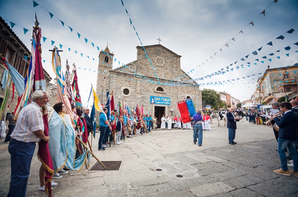
Luogosanto
A "sacred" and authentic place where time passes slowly, and a welcoming pilgrimage destination that owes its name to a devotion that characterises its community and to 22 sanctuaries spread out in the area. Luogosanto ("holy place") is a town of fewer than 1000 in the heart of Gallura, in the foothills of the granitic Monti Ghjuanni, famous for a Nuragic site with an intact (and visitable) "capanna delle riunioni" (meeting hut). The town was founded in the 13th century with the arrival of the Franciscans, who set up a convent, one of the first created while Saint Francis was still alive. Today, the renovated building hosts the Natività beata Vergine Maria Museum and an archive for documents on the Middle Ages in Gallura, which covers the local historical and religious events and displays the votive offerings donated to the Madonna Bambina over the centuries. The Basilica di Nostra Signora di Luogosanto, built by the Franciscans out of granite blocks in Romanesque style, is dedicated to the virgin. Inside you can find a wooden sculpture of the Madonna (‘Regina di Gallura’), while in the 18th century it received the priviledge of a holy door: since the 1970s, the door has been made of bronze, by Luca Luchetti, and is opened for pilgrims for one year every seven. According to legend, it was erected in the place where the virgin appeared to two friars, giving them instructions about the relics of San Nicola and San Trano. The monks met her on a rocky rise, where a sanctuary was built to the two martyrs in 1227, including the cave where they are said to have lived. Known as the San Trano Hermitage, the altar is made out of a single stone block, while the cave forms a natural apse.
After seeing the population decline over two centuries, Luogosanto began to grow again in the 17th century thanks to the stazzi, typical rural settlements: 350 were recorded within the area, and their history is documented in the Agnana Museum. Today, the town is composed of narrow paved streets and houses like ancestral homes, with iron balconies. A path leads out of the town towards other medieval sites, along paths running through oak forests and natural monuments, to be followed on foot, by bicycle or on horseback. You can visit the ruins of Villa de Sent Steva, a "working" community up until the mid-14th century composed of 16 spaces overlooking a small square. On the south-eastern corner are the ruins of the Palazzo di Baldu, which may have belonged to Ubaldo Visconti, a judge from Gallura (1225-38). The Church of Santo Stefano (17th century) is also part of the complex. On top of Mount San Leonardo is Balaiana Castle, accessed by a stairway. The castle dates back to the 11th century and was the summer residence of the judges. It remained intact until the arrival of the Aragonese conquerors. Following a path from the fort, you can reach the Church of San Leonardo, originally the castle's chapel, and today a rare example of Romanesque architecture in Gallura. Other nearby sanctuaries include; San Gavino di Li Coddi, covered in juniper, and San Salvatore, entirely made of granite. Near the town is the Church of San Quirico, which in early August hosts one of the rural festivals that animate the community from April to November. The festivals reach a peak in September, with the festa manna. In August, don't miss Calici DiVini, an opportunity to try Vermentino wine.
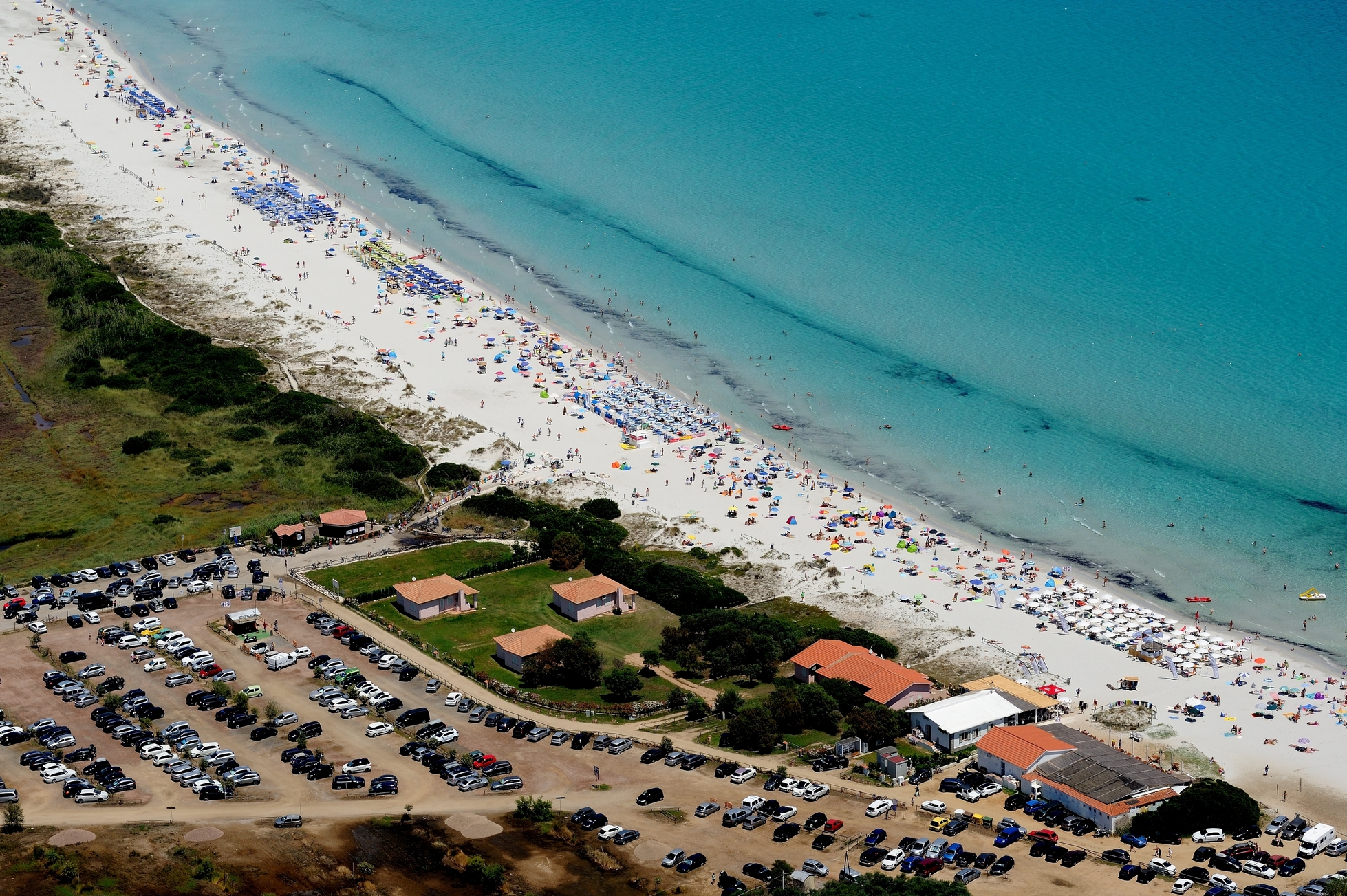
La Cinta
The most famous beach of San Teodoro in one of the Mediterranean’s most beautiful natural landscapes, accessible on foot from the northern outskirts of the town. The Cinta creates a 5-km arch of dunes of fine white sand that gently fade, without any rocks in sight, into a clear azure sea, scented with juniper, sea lilies and strawflowers, embellishing a landscape that has remained uncontaminated, in spite of its popularity. Its bottom is shallow and clear: this beach is beloved by families with children, teenagers and nature lovers.
The Cinta faces, towards the sea, the marine area of Punta Coda Cavallo – Tavolara Island, which rises from the sea with its majestic profile almost in front of the bay, and, towards the hinterland, the San Teodoro lagoon.
Thanks to its environmental variety, this is a lively corner of biodiversity where relaxing by the sea and a taste for adventure blend together nicely.
It is the ideal place for long walks. Try some bird watching and admire coots, little terns, red herons and mallard ducks living undisturbed in the lagoon. If you wish to admire pink flamingos from up close, you will be amazed: countless of these birds inhabit the salty waters near the dunes. The beach has all necessary amenities: parking area, tourist information spot (to better organise itineraries around the area), beach bar, beach equipment rental, canoe and paddleboat rental, excursions by dinghy boat, fishing excursions, water sports, sailing and kite surf lessons. For this exciting speciality, there is an area dedicated to lovers of active vacation (the kite zone).
La Cinta is a symbol of San Teodoro, and is closed, to the north, by Puntaldia. Soon after the promontory, you will find two of nature’s works of art, separated from each other by Capo Capicciolu: Lu Impostu, one kilometer of fine, white, soft sand, dotted with juniper trees and mimosas, and Cala Brandinchi, also known as Tahiti, one of the island’s main attractions. Further south, you will find s’Isuledda, no less beautiful, with its lovely sand and clear water.
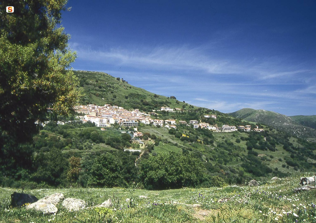
Calangianus
Famous for the production of cork, which has made it one of the richest Sardinian locations (and has ranked it amongst the top 100 most industrialised municipalities in Italy since 1979), Calangianus lies in a basin 500 metres above sea level, protected by granite and wooded hills of the Limbara massif, in the deepest parts of Gallura. The first mention of Calangianus, identified in Antiquity with the oppidum of Calangiani on the road between Olbia and Tibula (today’s Castelsardo), dates back to 1100. Its historic centre consists of streets paved in granite (another aspect of its prosperity), with stone houses arranged around the parish church of Santa Giusta. Also characterised by a 14th-century granite façade, it was enriched in the 16th century by a painting depicting the Assumption and in the early-20th century by frescoes and marble works. The Museo Diocesano d’Arte Sacra (Diocesan Museum of Sacred Art) is an exhibition space housed within the Oratory of Nostra Signora del Rosario, adjacent to the parish church. Here, a collection of precious pieces dating back to the 16th and 18th centuries can be admired, being especially liturgical objects.
In the oldest part of the village, stands the Chiesa di Sant’Anna (1665), also in granite, which houses a 19th-century painting depicting the saint. On the outskirts is the Chiesa di Santa Maria degli Angeli, behind which is the Capuchin monastery, built in 1705 and suppressed in 1866. Now restored, it currently houses the cork museum, which recounts the symbolic tradition of the town, displaying ancient machinery and objects in cork. In the countryside stand the churches of Santa Caterina and San Leonardo, dating back to 1623. Amongst the cork trees of the park of the same name, is the Santuario di San Sebastiano Martyr from the 18th century. On a hill on the edge of the village is the Sigara spring, a destination for walks through forests and for breath-taking views. In the locality Badu Mela in the cork woods near the town, on the northern slopes of the Monte di Deu are the Tombe dei Giganti (Giants' Graves) of Pascareddha, a monument from the mid- to late-Bronze Age (1700-1400 BC). Other interesting archaeological sites from the second millennium BC include the sacred spring of Li Paladini and the Nuragic-era Agnu, flanked by a dolmen. Of the other eight Calangese nuraghe megalithic edifices, three are in good condition. The territory of Calangianus occupies the eastern side of Mount Limbara, where forests of holm oaks, conifers and Mediterranean scrub thrive. In particular, the luxuriant valley of the Rio Santu Paulu, an evocative part of Parco del Limbara, with pathways to travel along by foot and by bike, along which splendid views can be enjoyed, as well as in the Parco di Stazzana, embellished with centuries-old holm oaks.
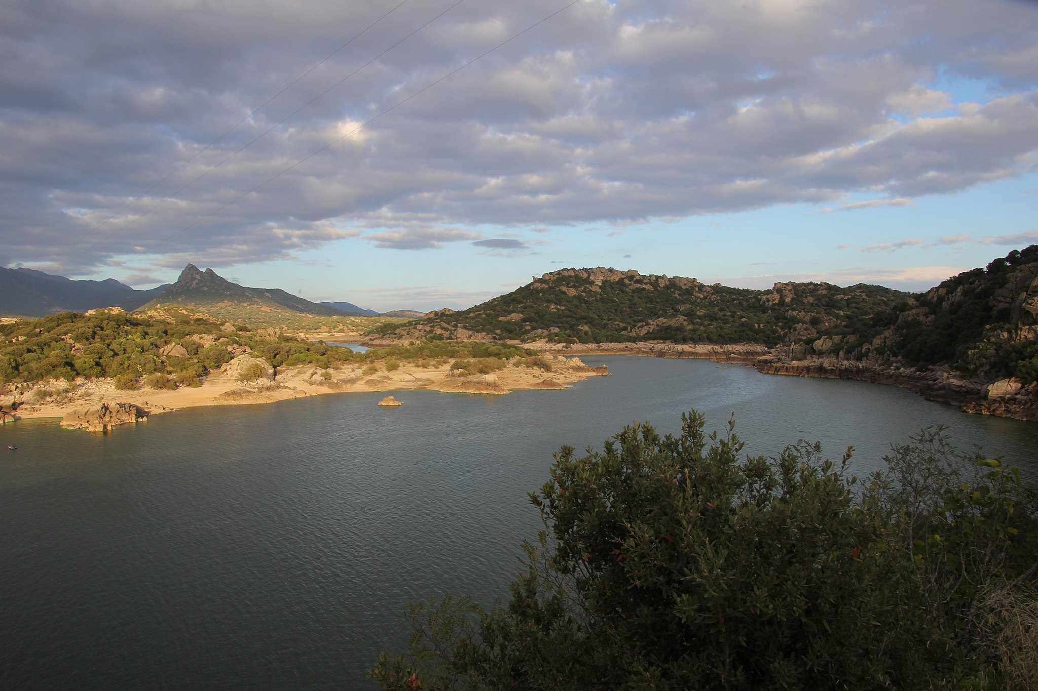
Oschiri
On the border between Logudoro and Gallura, it stretches at the feet of the Limbara granitic massif, looking over the splendid panorama of Lake Coghinas, a destination of choice for sport fishing, water skiing and kayaking enthusiasts. Oschiri is an agro-pastoral town of 3300 inhabitants, known for its beef, vermentino wine, cheeses and above all, panadas, a puff pastry stuffed with meat and natural flavourings. In August, a festival in honour of this local culinary symbol is held contemporaneously with the Agro-food Festival of Gallura. The town is surrounded by valleys dotted with holm and cork oaks and Mediterranean shrubs as far as the eye can see. An excursion into the Su Filigosu Forest, an animal heaven where you can admire red and fallow deer, weasels, mouflons and soaring eagles, falcons and sparrow hawks, is a must.
Low houses and narrow roads paved with stone characterize the town’s historic centre. Here, stands the 18th century Parish of the Beata Vergine Immacolata, rebuilt in in 1903, and the 11th century Romanesque Church of San Demetrio. Other churches dating to the same century include the country churches of San Giorgio, San Pietro, San Sebastiano, Nostra Signora di Othi (the parish of a village inhabited since the 17th century), and above all, the Church of Nostra Signora di Castro, a Cathedral from the end of the 11th century to 1508, located five kilometres from Oschiri. The complex, surrounded by walls, is composed of a church, cumbessias (housing for pilgrims) and a two-story building. The church, a contemporary of the Church of Nostra Signora del Regno in Ardara, reflects the Lombard Romanesque style with a façade of pink trachyte. Its feast day is on Sunday after Easter. The former cathedral is all that remains of an ancient village of Castra: the area, inhabited from the Nuragic era to early Medieval period, is one of the most ‘Romanized’ areas on the island. The Hill of San Simeone contains the ruins of a fortified settlement, the castrum of Luguido, a military centre and a rest and control station where coin stashes have been unearthed. There may have been continuity between the Roman era and the Byzantine: archaeological and cultural evidence points to a spreading of Greek soldiers, merchants and religious figures.
The earliest evidence of human presence dates to 3000 BC: 70 Domus de Janas, half of which are contained in the necropolis of Malghesi (25 domuses) and Pedredu (13). Three more are immersed in the greenery of Puttu Iscia. Neolithic sacred and funerary rites are also referenced by the dolmen and menhir of Mount Cuccu, Mount Ulìa and Mount Berre. The most famous and enigmatic pre-Nuragic site in the area is the Complex of Santo Stefano, an area in the town’s outskirts rich in honeycombed rocks, composed of eight domuses and the (possibly Byzantine) Church of Santo Stefano. Here, you can admire a rock altar and storiated granite walls in which niches have been carved with geometric incisions and cup marks. About 60 Nuragic settlements have been recorded in the area surrounding Oschiri, including the monotowers of Accas Alvas, Longu and Monte Uri, with a unique four-cornered cross-section, and the complexes of Nuraconi and Sa Conchedda. The Nuragic site of Lughéria has produced a famous miniature bronze cart, possibly a box for storing precious objects, exhibited at MuseOs along with two votive bronze boats and coins. The museum is also ethnographic and dedicated to the Roman castrum.
Bortigiadas
A typical agricultural-pastoral village, Bortigiadas was once the Logudorese enclave in Gallura and is the smallest Municipality in the north-east of the Island, with less than 800 inhabitants living in 22 villages and stazzi (rural settlements), at a distance of some tens of kilometres from the centre. Bortigiadas rises up at an altitude of 450 metres above sea level, in the midst of elevations that reach a thousand metres, overlooking an area that extends to the east of the rivers Coghinas and Tempio Pausania, presenting interesting geological features. It is no coincidence that, since 1984, it has hosted the Mineralogical Museum, exhibiting 800 examples of minerals representing 250 species, mainly from the area of the village and also from other Sardinian territories. Amongst the finds are numerous pieces that are the sole examples on the Island. Speaking of geology, not to be missed in Punta Salizi are the rocks shaped by the wind over the centuries, forming marvellous natural sculptures, rising up between the Mediterranean scrub and cork oak woods, amidst splendid panoramas.
The first documentary evidence of the area being inhabited date back to the 14th century, under the name of Orticlada, which belonged to the diocese of Civita (today’s Olbia). Other texts of the Crown of Aragon mention Gortiglaca or Bortiglassa. The current form of Bortigiadas is confirmed in 1779. Today, the Gallurese dialect is spoken, but until the middle of the 20th century, the local language was Logudorese. The economy is mainly based on the working the land, in particular via viticulture, it being the production area of the Vermentino di Gallura wine. Agriculture, crafts, forestry and rural accommodation all gravitate around the land. The village is characterised by narrow streets that are built around the parish church of San Nicola di Bari, constructed in 1607 with exposed granite cantons in the façade and gabled roof. The internal barrel vault is supported by three arches, whilst artistic windows decorate the windows. Held within is a painting from the late-17th century, San Nicola e San Lucifero Difensori della Divina Maternità (Saint Nicholas and Saint Lucifer Defenders of the Divine Mother and Child). Local devotion is symbolised by six other churches, all in the inhabited centre, including the 18th-century Santa Croce (restored in 1980) and the Chiesa del Carmelo in the typical Gallura style of the 18th century, with the exception of San Pancrazio, just outside the village, where the most beloved festival of the community is held at the end of September. Amongst the ‘profane’ festivals, not to be missed is the beer festival in mid-August.
The domus de Janas of Tisiennari, carved into the rock and comprised of four decorated rooms, is the oldest remnant in the territory, dating back to the late Neolithic (IV millennium BC). A cell presents an architectural typology with a false door surmounted by taurine horns. According to some archaeologists, man would have inhabited Tisiennari since Lower Palaeolithic times, 300 thousand years ago. Other Domus de Janas show human settlements on the right bank of the Coghinas. Close to the town is the Su Nuraghe complex, which dates back to the Nuragic era. In Roman times, Bortigiadas possibly gravitated along the road from Olbia to Tibula, near the current Castelsardo.

La Marmorata
It lies at the foot of the promontory that stretches to the northernmost point of Sardinia, facing a turquoise sea reflecting shades of emerald green, with the splendid northern islands of the Park of the Maddalena Archipelago in front of it. The beach of Marmorata occupies a stretch of coast at the base of Capo Falcone, in the territory of Santa Teresa Gallura, five kilometres from the residential area of the little Gallura town. In reality, the long stretch of soft, white sand - with some hints of pink near the shoreline - is divided into two parts by a stretch of reef, so there are really two beaches. The smaller beach, to the north, is known as Marmoratina or La Laurina. The sea and the landscape, however, share the same beauty: you can admire waters with spectacular shades of emerald green and a few granite rocks appearing on the surface. On the horizon, you can see the most distant islands of the Maddalena archipelago: Budelli, Razzoli and Santa Maria. Then, towards the promontory, you’ll notice the islet of La Marmorata: it can be reached aboard a pedalo and, on it, you can see what remains of a granite quarry from the Roman era.
The beach has parking, refreshment areas, deckchair and beach umbrella rental services and there is also a small children’s play area in the water. The older children can have fun riding the waves: La Marmorata is an excellent spot for wind and kite surfing, especially when the northeasterly wind is blowing. The transparency of the water, however, is perfect for snorkelling, while diving and scuba diving enthusiasts can explore the wreck of The Angelica, a cargo ship that sank in the 1960s because of a sea storm. One of the derricks of the wreck is sticking a few metres out of the water, in front of the islet. Setting off from the small Marmorata beach, along a trekking trail, you can enter the promontory of Capo Falcone until you get to Punta Falcone, the extreme northern boundary of Sardinia, considered an island. The path leads you through the area of a military fortification, built at the beginning of the Second World War: you will see small forts, barracks, lookout posts and, above all, the ruins of the Batteria Ferrero. It had five anti-ship cannons arranged on staggered levels and positioned in circular emplacements. Around it, there are traces of bunkers and tracks. You will be surprised to see some buildings ‘disguised’ as nuraghi. Seven hundred metres further south, you can also see what remains of the former semaphore of Capo Falcone that, during the 20th century, regulated naval traffic in the dangerous Strait of Bonifacio.
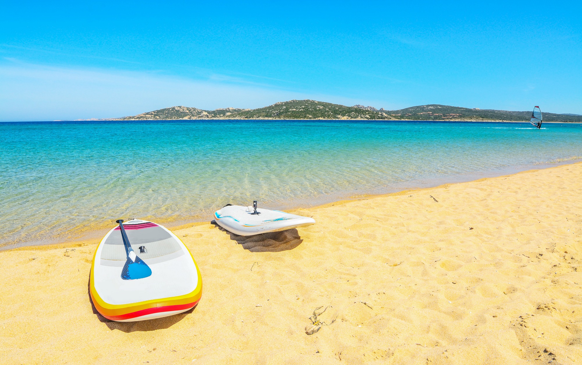
Porto Pollo
A bay with turquoise waters and fine white sand, surrounded by Mediterranean scrub bushes. Halfway between Palau and Santa Teresa Gallura, near the mouth of the Liscia, Porto Pollo (Portu Puddu in Gallura dialect) unites mainland and the beautiful Isola dei Gabbiani (or Isuledda) through a thin strip of sand. The two isthmus beaches (the second is called dell’Arenaria) fan out with dunes covered in lavender, mastics and juniper trees, and are a natural gym for water sports. The area is constantly hit by winds, sometimes strong ones, which is why it is a particularly popular destination among sailors and practitioners of windsurfing and kite surfing. Somewhere along the bay, there will always be perfect surfing conditions, alternating with flat sea somewhere else.
For those who love windsurfing, hair-blowing wind, full sails and white foam on the waves are a constant in this beach, as in nearby Barrabisa. For those less interested in sports or looking for relaxation, enjoy calm days and poetic sunsets, sheltered from the wind.
The bay is very popular. It offers plenty of parking (for campers as well) and is accessible to disabled persons. Thanks to its shallow bottom, it is suitable for children. It is possible to rent umbrellas and other beach equipment, and there is also a windsurfing and sailing school. Bars, restaurants, hotels and camping sites are immersed in secluded rocky coves, surrounded by the colours and smells of the Mediterranean scrub, characteristic of the Gallura coast. Do not miss the chance to visit all 18 hectares of the naturalistic paradise of Isola dei Gabbiani, and, nearby, visit the other treasures of Palau: the wild beauty of Punta Sardegna, the exotic appearance of Cala Trana, splendid Porto Faro, and the natural monument of Roccia dell’Orso. Admire the view offered by the islands of the Maddalena Archipelago.