
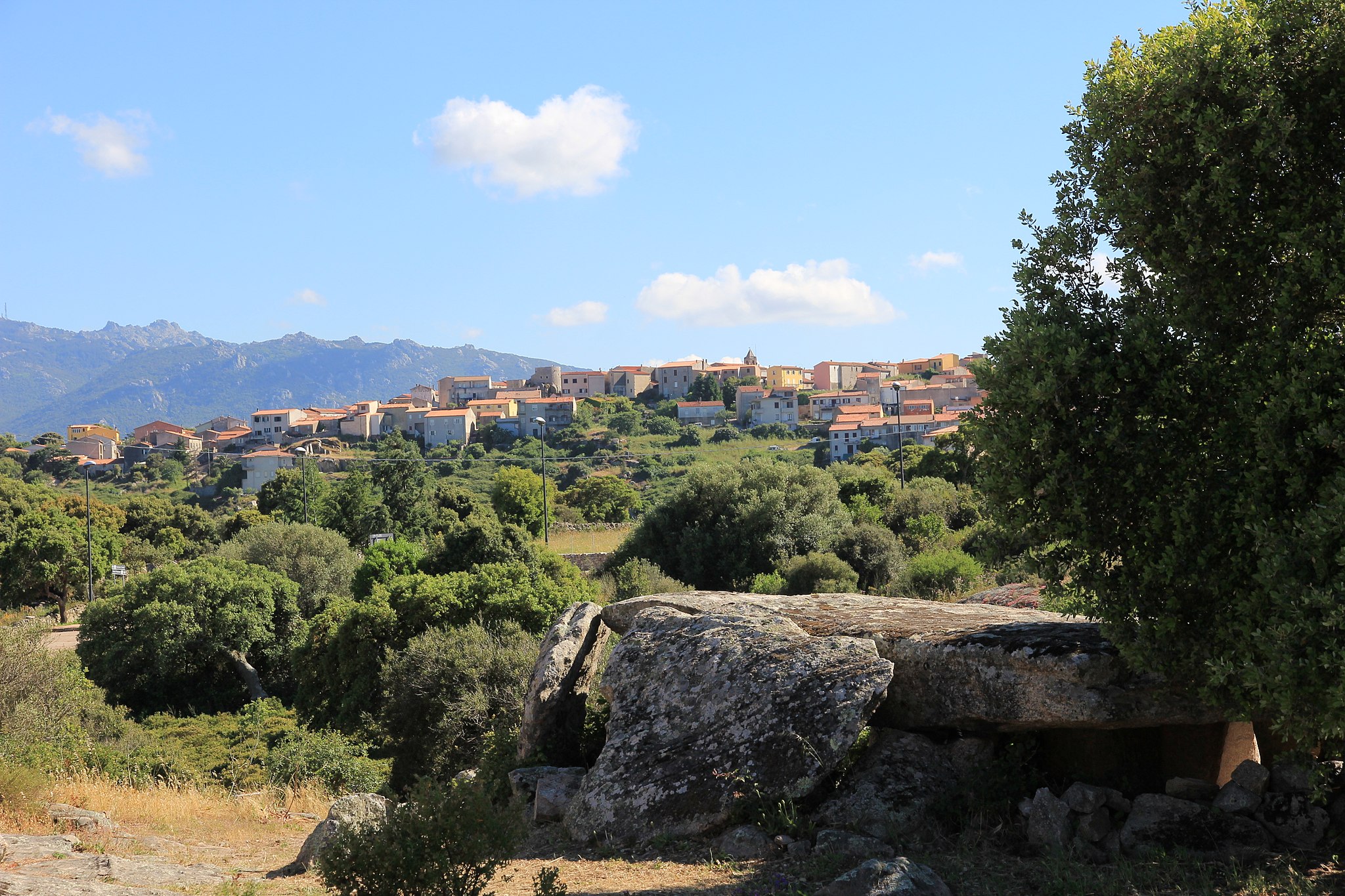
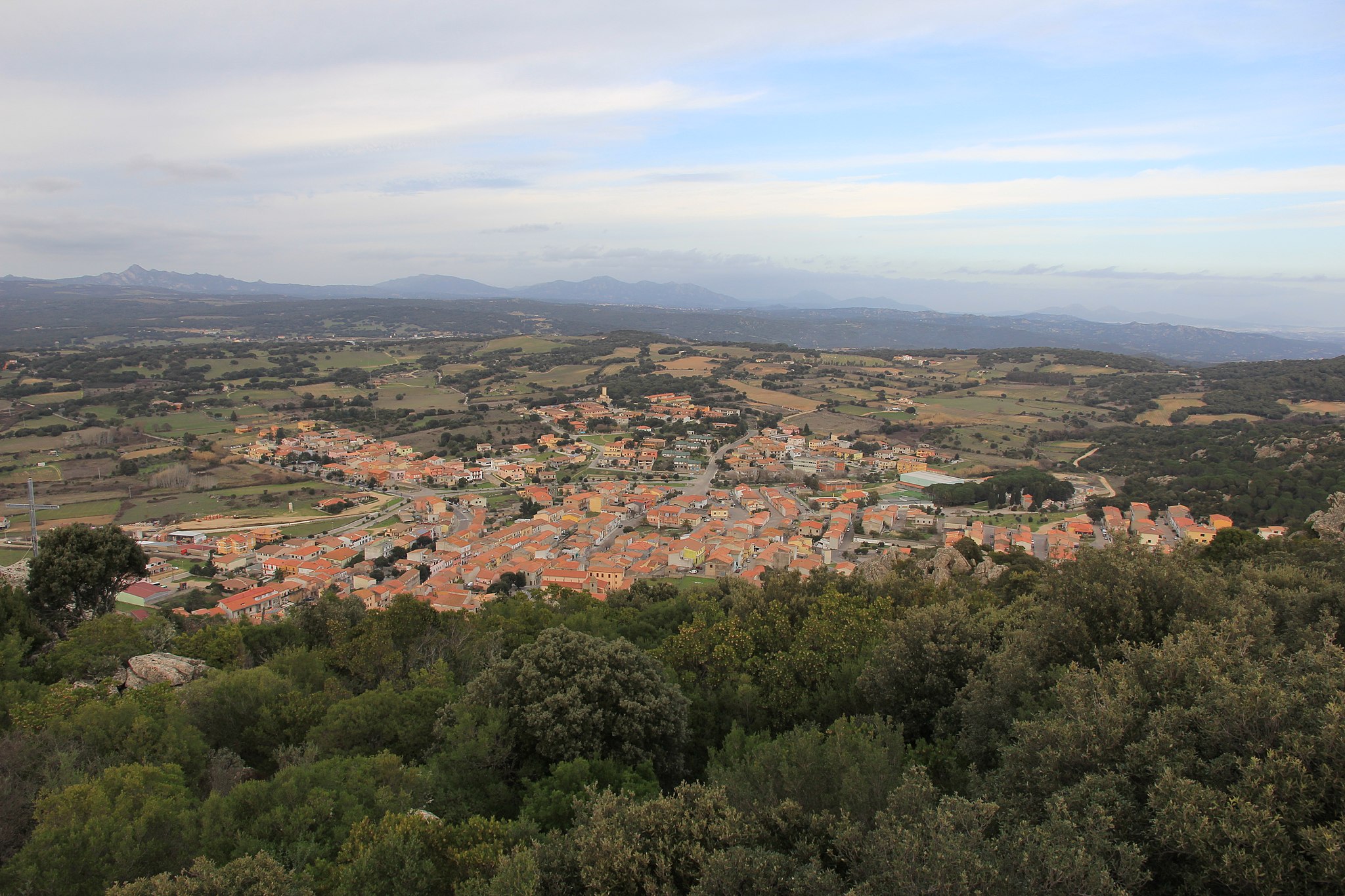
Luras
Luras is the home of the dolmen: of an original 78, four of the remaining intact examples on the island are here. This town of 2500 inhabitants is set 500 metres above sea level on a granite bedrock to the far north-eastern side of Mount Limbara. Despite being well within the Gallura region, locals speak the Logudorese dialect. There are two theories about the town's origins: founded as an Etruscan colony, or by the Jews deported by Emperor Tiberius (19 AD). From the Middle Ages to the 18th century it was known as Villa Lauras, and it reached peak splendour in the mid-19th century, thanks to trade, agriculture and sheep-farming. Today, the economy is based on agriculture and craft trades, in particular cork, granite and the production of vermentino and nebiolo wine.
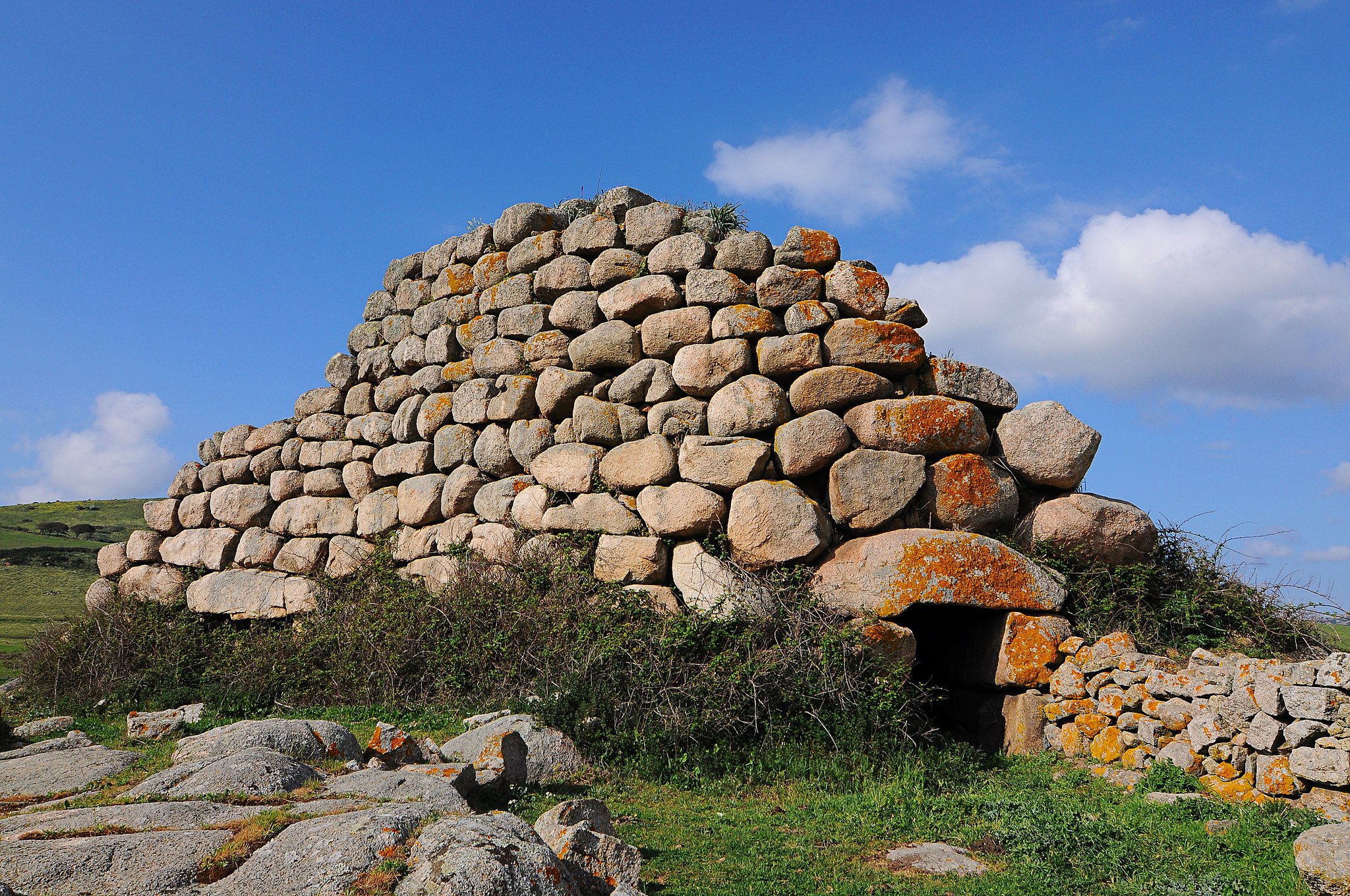
The area has been inhabited since prehistoric times. The Bronze Age left the remains of six nuraghes, while the four dolmens (or allée couverte) found near the town date from the pre-nuraghic period, 3500-2700 BC, and can be compared to similar Basque, Catalan, French, Corsican and Balearic Island collective burials (and places of worship). The townsfolk called them sepulteras de zigantes or de paladinos, in the belief that the enormous rocks used to build them could not have been brought by "normal" men, but only by giants. The Ladas dolmen is a tunnel six metres long and two metres high, covered by slabs and with an apse. The stone at the back has a surface area of 15 square metres. The Ciuledda dolmen is similar but on a reduced scale and with a semi-circular layout, while the Alzoledda and Billella ones are rectangular, with a trapezoidal chamber.
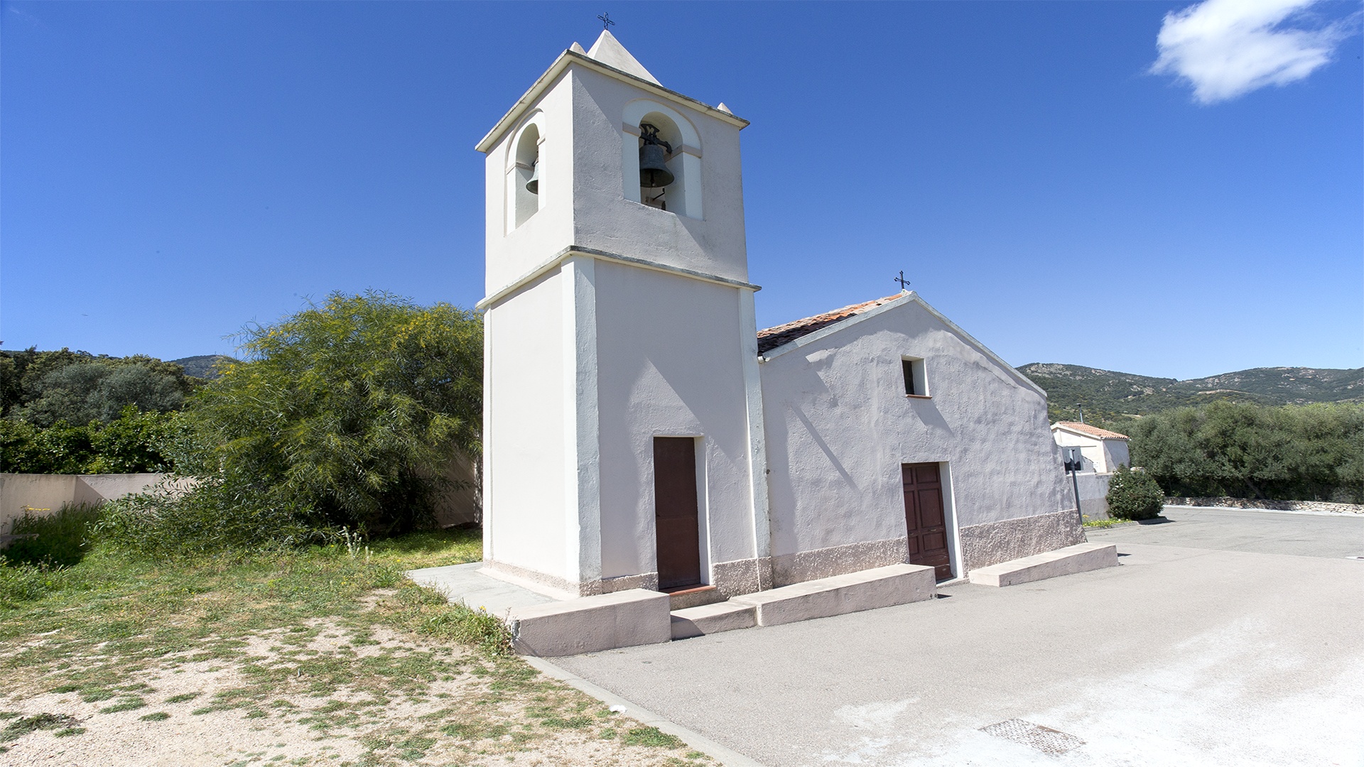
In the middle of the town is the parish church of Nostra Signora del Rosario (18th century), which holds three valuable paintings: the Vergine del Rosario (17th century), Pentecoste (1874) and Anime Purganti (1927), as well as two marble lions. Opposite the parish church, is the small church of Santa Croce (1677), where the brotherhood responsible for the Holy Week rites and the living nativity scene in traditional costume at Christmas is based. Next to it is the home of artist Tonino Forteleoni, where his works in cork are on display. Nearby, a typical granite home hosts the Galluras museum, an expression of ancient local culture: 5000 remains from the 15th to 20th century are on display, including the macabre hammer used by s'accabadora for ante litteram euthanasia. The town also has the churches of San Pietro (17th century) and Purgatorio (18th century). Rural churches include San Bartolomeo di Karana, which is next to the s'ozzastru, a wild olive tree that has a circumference of 12 metres, and which is estimated to be more than 3000 years old, making it one of the oldest in Europe. It is a natural monument and is on the list of the oldest trees in Italy. Together with "younger" trees, it overlooks the shores of Lake Liscia, whose waters reflect the surrounding granite mountains. The Trenino Verde railway passes right by this natural spectacle, stopping at Luras.
Sos Aranzos
Sos Aranzos is found at Sos Aranzos, in the commune of Golfo Aranci. The shore has fine white sand with rocky granite outcrops and wonderful cliffs. The isolated Sos Aranzos beach is one of the most suggestive of the Golfo Aranci coastline, with a view over the Island of Tavolara and Capo Figaro, with its shining extremely fine sand that contrasts with the variegated colours of the water, from green to turquoise blue. It is one of the most popular corners in this area. The little bay set among the cliffs represents a quiet peaceful oasis for the lovers of isolated and secluded gorges. According to an old tradition the name of the beach is linked to the so called “balls” of posidonia formed b y the sea and deposited along the shore.
Nuraghe Izzana
Once you arrive in the heart of the vast Piana dei Grandi Sassi (Plain of the Big Stones), also called Valle della Luna (Valley of the Moon), surrounded by large granite boulders featuring anthropomorphic shapes, you will see an impressive tower rising up before your eyes, made of huge, roughly-hewn granite blocks positioned in irregular rows. It is the majestic Nuraghe Izzana, probably the largest Nuragic building in the whole of Gallura, on the border between the territories of Tempio Pausania and Aggius. From its summit, you can admire a wonderful 360-degree view: you’ll be struck by the wild beauty of the nature all around you. Here, the erosion caused by water and wind has dug out and shaped small and large cavities, such as caves and tafoni.
The grandeur and complexity of the Izzana brings to mind another building in Alta Gallura, the Nuraghe Majori, which stands near the present-day town of Tempio. They have the typical characteristics of the primordial ‘corridor-type’ nuraghi in common, which also differentiates them from many other more recent Nuragic structures. In fact, the Nuraghe Izzana dates back to between the end of the Early Bronze Age, at the beginning of the ‘stone tower’ civilisation, and the Final Bronze Age. The building has an oblong triangular shape with rounded corners. The chamber of the central tower has a tholos roof and is still intact, while the lateral ones, positioned at different heights from the ground, are now partially damaged but can be reached thanks to a series of internal corridors that run around the building. Two corridors branch off from the central chamber and one leads to four small cells arranged symmetrically.
One of the unusual features of the building is that it has various entrances: one in the south-east wall, leading into a short-splayed passageway covered by a jack arch that, in turn, leads to the chamber with a tholos roof. The second and main entrance is located in the south-west wall, built out of large well-worked stones, like the whole southern part of the nuraghe, and is the most recent. The entrance leads into a long corridor with an angular roof that, after a narrowing, leads you to the central chamber, which has a five-metre diameter and was built using rounded blocks that ‘rise’ in even rows up to the ogival closure. A flight of steps, now collapsed, led into a corridor with openings towards two other corridors. The first, longer one stretches diagonally, while the second slightly splayed one leads into a small uneven cell. On the left wall of the small room, you will notice the opening of another curved room. Another entrance to a straight corridor will take you out of the building through a narrow tunnel. The labyrinth-type layout has led some scholars to speak of a ‘nuraghe-trap’, built this way to confuse assailants. The unusual construction technique used and the uniqueness of the layout indicate that the construction is much more likely to be the result of several interventions that took place over time, the most recent of which may have modified and extended the initial buildings.

Cala Sassari
Secluded and with a wild appearance, thanks to the surrounding scenery, Cala Sassari will surprise you with the colours that the sea, sand and cliffs take on in the sunlight. The beach is about 500 metres long, with mixed golden and whitish-coloured grains of sand with some hints of brown. The bay is surrounded by Mediterranean scrub, which also covers the rocky peaks that surround it, giving the sea reflections of emerald green and turquoise. The transparent waters reveal a sandy seabed sloping gently towards the open sea and are shallow near the shoreline, allowing children to swim and play peacefully and the whole family to enjoy some relaxation. The beach is well sheltered from the wind and offers various services: parking, bars and restaurants, deckchair, beach umbrella and boat rentals and services linked to accessibility.
Cala Sassari is a destination for diving, snorkelling and underwater fishing enthusiasts, but it is also an ideal destination for enjoying splendid views: in front of you, you will see an islet known as Punta Pedrosa, from the name of the promontory to the south; further in the distance, you will see the majestic profile of the island of Tavolara, while looking north, you’ll see the village of Golfo Aranci and the islet of Figarolo.
You can easily reach the beach by following provincial road SP 82 between Olbia and Golfo Aranci and taking the well-signposted exit heading east. The surroundings offer countless other coastal treasures... the area of Golfo Aranci alone has more than twenty beaches. On the sides of Cala Sassari, in addition to the little cove of Punta Pedrosa, you will also find the Spiaggia Bianca (White Beach); to the south you will find the small Sos Aranzos, with white sand and a transparent sea. Near the town, lie the Cinque Spiagge (Five Beaches) one after the other, perfect for a holiday filled with relaxation and fun, thanks to all the services and convenience. If you are looking for wild coves surrounded by uncontaminated nature, you can head towards Capo Figari and explore the other ‘Aranci’ pearls: Cala Sabina, Cala Moresca and Cala del Sonno.
Sant'Antonio di Gallura
Rising to 350 metres high, Sant’Antonio di Gallura is surrounded by granite mountains and deep valleys lush with oaks, holm oaks and Mediterranean scrub, backdropping the Lago del Liscia. The village is populated by 1,500 inhabitants, including those of the hamlet Priatu and various villages. Until 1979, when it became an independent municipality, it was called Sant’Antonio di Calangianus, after the municipality on which it depended. An obligatory waypoint from the inland heading towards Costa Smeralda and the Parco dell’Arcipelago della Maddalena, it is the ‘heir’ of Villa de Castro, whose existence is documented by Liber Fondachi (1317) and Compartiment de Sardenja (1358) and of findings of burials, jewels and coins, including a Genoese coin from 7th-8th century. The early medieval village was located at the foot of the Lu Naracu overlook, today the highest point of the town from which you will admire views ranging from the Limbara massif to the Arzachena and Palau sea. From this height, it is possible to see the hills dominated by the stazzi (rural settlements), fundamental elements of the Gallura agricultural-pastoral culture. It is surrounded by Liscia, the largest artificial reservoir in the island’s north, formed by the dam of the same name. You can coast along the side of Sant’Antonio aboard the Trenino Verde (Green Train) and cross its waters aboard a paddle boat. On the side of Luras stand the 1,000-year-old olive trees of Carana.
The name Lu Nuracu, together with the toponym Lu Nurachéddu (in Campu d’Idda), are the ‘clues’ to the territory’s use in the Nuragic age. Near the viewpoint stands the Chiesa di Sant’Andrea, dating back to the mid-18th century and elected as a parish in 1907 (for only five years). Around the small sanctuary, the new inhabited nucleus developed. With the increase in population, the construction of a major church was necessary. Hence, the new parish church of Sant’Antonio Abate was built in 1912, having a basilica layout with three naves divided by arches, a high altar and frescoed apse. The patron is celebrated in mid-January with the Fuochi di Sant’Antonio Abate event. Not to be missed is Palazzo Mannu, in the noble architecture of the Gallurese, built entirely of granite. Doors and windows are outlined by architraves and jambs, whilst the upper floors are adorned with wrought iron balconies. The interior preserves furnishings and structures from the early 20th century. Nearby are charming country churches, and venues for hosting events, where you will discover the most authentic Gallura delights and savour delicacies such as Zuppa Gallurese and Mazza Frissa. There is the Madonna di La Crucitta and the sanctuary of San Giacomo, celebrated in May, San Leonardo and San Giuseppe, celebrated in June, and the rocky church of San Costantino, perhaps of early medieval origin, next to which there is Lu Pulteddu, a sort of ‘window’ that, according to tradition, upon being passed by three times, cures abdominal pain.
Loiri Porto San Paolo
The two main residential areas, little villages and stazzi, merge together into a single dimension. The little village of Loiri and the marine village of Porto San Paolo merged to create a single Municipality in 1979, along with a myriad of districts surrounded by Mediterranean greenery. A majestic centuries-old olive tree welcomes you at the entrance to Loiri: the municipal 'capital' has three thousand 500 inhabitants and stands amidst low hills, about 15 kilometres from the sea. The coastal village, which has accommodation facilities, services and a modern tourist port, is frequented by 15 thousand people in the summer. According to legend, the apostle Paul stopped here in Antiquity, before withdrawing to a hermitage deep in the Gallura area.
Loiri Porto San Paolo, which is exactly halfway between Olbia and San Teodoro, shares 15 thousand hectares of sea and 40 coastal kilometres of the marine area of Capo Coda Cavallo with them. Ferry services leave here every day allowing you to visit the wonders of the impressive island of Tavolara and the smaller islands of Molara, Molarotto, Piana and the Isola dei Cavalli. During Una Notte in Italia (A Night in Italy), the famous film festival on the island of Tavolara, you will be in the company of actors and film directors starring in the event along the stretch from Porto San Paolo to the island. Another event not to be missed is the nautical fair.
There are eight churches in the villages and hamlets: worthy of note is the church of Santa Giusta, in the district of the same name, the first medieval centre of the future Municipality and, in Loiri, the parish church of San Nicola di Bari, featuring a façade made of exposed granite stone and an architrave portal, with a bas-relief depicting a scene from the life of the saint. There are patron saints celebrations associated with the religious buildings, in which the Choir of Loiri performs: San Nicola (St Nicholas) is celebrated at the end of August and Sant'Antonio da Padova (St Anthony of Padua), in mid-June.
The first sporadic traces of humans in the territory date back to the Neolithic age. It was later frequented much more intensely: on a hill near Loiri, you will see ruins from the Nuragic period. During the Punic-Roman era, this area continued to be frequented uninterruptedly, as in the district of Enas.
Monti
It is situated on the slopes of the Mount Limbara massif, inside a lush basin filled with cork oaks, Mediterranean shrubs, vineyards and granite masses, half an hour from Gallura’s enchanting sea. Monti, a town in the Monte Acuto historical territory with a population of 2500, is known for its vineyards producing vermentino, the only Sardinian wine to have (since 1996) the Denomination of Controlled and Guaranteed Origin, the highest recognition earned by a local wine. In August, a festival is held to celebrate this prized white wine with a subtle but intense aroma that pairs to perfection with fish dishes. Speaking of cuisine, the sa suppa, a day-old spianata (flatbread) seasoned with cow-milk cheese and grated sheep milk cheese, and drowned in mutton broth, is a local pride and joy. Other characteristic dishes include maccarrones de manu nostra, hand-made gnocchetti, tattalliu, spit-roasted offal, ‘baci d’angelo’ and sa niuledda sweets. In addition to food and wine, the territory boasts architectural, natural and archaeological attractions. The town’s historical centre still contains buildings with granite ashlars. The bell tower of the 17th century Parish of San Gavino is of particular note. South of the town, extends the Forest of Monte Olia, a natural park of holly and common oaks, strawberry trees and heath sheltering an oasis for wildlife repopulation: roe and red deer, mouflon and rare birds of prey, such as falcons and buzzards. If you head from town towards Alà dei Sardi, you will reach the s’Ambiddalzu plateau, which offers a splendid, solitary landscape of shrubs and wind-eroded granite masses. Along the way, you will pass by the Church of San Paolo Eremita. Although consecrated in 1348 (as recorded in parish records), its current architectural structure of natural stone dates to the 17th century. The saint’s Feast Day is celebrated in mid-August with a popular pilgrimage along the road linking the town to the sanctuary. A stop at the Sa Turrida panoramic viewpoint with its view of the entire Olbia valley, from Tavolara island to Coghinas lake, is a must.
The first evidence of human presence at Monti dates to the Neolithic. The tafoni of Mount Fulcadu and Su Canale may have been burial sites, while the allèe couverte in Terra is one for certain. The Bronze Age is represented by two Giant’s Tombs and a dozen nuraghes, including Nuraghe Logu with a tower leaning against a large granite outcrop. During the Roman period, the Karalis-Olbia route passed through the area. The Byzantine church has also left its mark: rites with Greek roots are still practiced and the Church of San Michele Arcangelo, with the adjacent remains of stone sepulchres and huts still stands. In the 13th century, the Doria family built the De Castra Castle in Monti. Its ruins are still visible. The fortress was later taken by the Pisans and the territory by the Malaspina family.
Padru
It emerged around 1700, perhaps already a Roman site, and became a Municipality in 1996. Padru is a small village in Gallura, with just over two thousand inhabitants, and its territory is on the border of the splendid park of the Oasis of Tepilora, which can be reached from its most distant and evocative district, Pedrabianca, with its houses made of stone and mud that climb up the white quartz rocks. From Sa Contra 'e S'Ifferru, there is a 360-degree view of the valleys, hills and mountains over half of Sardinia. From the village, you will reach evocative panoramic and naturalistic areas, with woods and springs, like the forests of Sa Pianedda and S'Ozzastreddu. From the 'terrace' of the peak of mount Nieddu (just under a thousand metres high) you can admire the splendid setting of the coast of San Teodoro and the Tavolara marine area. All the itineraries lead through large holm oak forests, cork oak forests and Mediterranean scrub, inhabited by mammals and birds of prey, like the golden eagle and hawks. In the autumn, the woods offer a generous variety of mushrooms. In the past, up until almost the end of the 19th century, the forests were practically impenetrable and, still today, the cork oaks create mysterious atmospheres. The territory is perfect for excursions on foot, on horseback or by mountain bike. You will find refreshments in the spaces equipped for picnics, cooled by the water from the springs, among which that of Sos Pantamos. Among the itineraries, in a land rich with rivers and torrents, you can discover the fluvial ones by kayak. Along the road that leads to the picturesque village of Pedrabianca, you can admire rocks with unusual shapes, like Sa Conchedda de Fizza Ona. Nearby, there is another extraordinary place: the Usinavà forest. From the district of Sa Serra, you will reach the little rural church of Sant'Elia, originally built in the 15th century. At the end of May, celebrations take place to honour the saint. All around, you will find a myriad of uninhabited villages, like Poltolu, with small granite houses, Baddevera and the Stazzi (rural settlements) of Avrio, Giuscherra Giuscherreddu and Piras.
You can combine archaeology with nature. About one kilometre from the residential area, in the direction of Olbia, there is the complex of Santu Miali, nestled in a splendid green setting. In a valley rich with woods, you will find the remains of a large Roman building (possibly a rural villa), a vast necropolis with 15 interments and the remains of two medieval churches, one of which featuring a bi-apsidal hall. As well as the substantial number of ceramic fragments, a 'group of coins' consisting of about 3500 minute silver coins was found in the tombs, as well as Roman coins and various necklaces.

Budoni
The hills surround the town, which features a beautiful medieval stone village. The old town, full of history and public places, is the heart of a lively nightlife: clubs, places to meet and restaurants make for a cheerful atmosphere all year long, and especially during the summer season.
Among the wonders of the area are Li Cucutti, Baia Sant'Anna and Cala Budoni. The soft white sand and the Mediterranean brush, which surrounds beaches of extraordinary beauty, capture and inebriate the gaze. Cala Ottiolu, with its shallow and green waters, is one of the most popular bays and is located near Porto Ottiolu, the main tourist starting point for inshore trips.
The feast of the Assumption in Budoni is undoubtedly the most beloved and anticipated: piazzas awash with music and joy where visitors join in one single celebration not to be missed, with dancing in discos and dreamy clubs. The tower of Su Entosu, a nuraghe-look-out located on a granite peak, the Conca and Bentu nuraghe and the Domus de Janas Agliola are of great historical value.
If you love the old charm, the animal pens of St. Peter will take you back in time; a path through ancient pastoral houses, built with thousand-year-old stones, mortar and mud, that bear witness to the look of nineteenth century countryside Sardinian villages. The colorful charm of the rooms and courtyards still tell stories of ancient life.
Aglientu
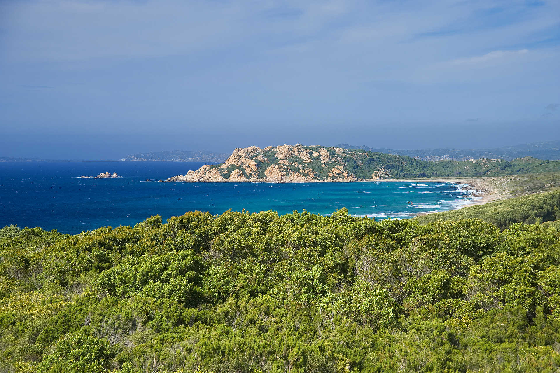
Aglientu is located a few kilometres from the sea, in an area predominantly rich in granite. Its landscape is characterised by majestic boulders and green valleys that slope down towards sandy shores with high desert-like dunes alternating with imposing cliffs. Just like Monti Russu, a pink granite relief with a rounded shape extends towards the Gulf of Asinara. The 22-kilometre-long coastline, with extensive unspoilt stretches, is renowned for the beautiful beaches. Amongst the largest is Rena Majore (on the border of the Santa Teresa Gallura territory), Litarroni and Vignola, a fishing village where a Spanish tower from 1606 stands 12 metres high, from which a panoramic view of the sea and inland can be enjoyed.
The name of the town has Latin roots, with the meaning of white, also being present in other place names in the area (Montagliu, Agliacana, Frati Agli and Agliu). The discovery of stone tools dates the presence of man here since the ancient Neolithic period. Numerous Nuraghes, including Tuttusoni and Finucchjaglia, are mainly distributed along the coast. In Roman times within the area, at the height of the current Aglientu, there was a horse exchange station along the road from Porto Torres to Santa Teresa Gallura. The town centre was built in 1776, when Vittorio Amedeo III ordered the construction of the church of San Francesco d’Assisi. A few decades later, constructions went up in which religious ceremonies, socio-economic activities and trade fairs were held during festivities. Around 1850, a number of wealthy families built houses, establishing the first nucleus of Aglientu, originally a hamlet of Tempio Pausania, before becoming an independent municipality in 1959.
There are numerous town churches: the oldest is the 17th-century one dedicated to San Pancrazio (who is celebrated on 25th January), with much more recent constructions being those dedicated to San Giovanni and San Silverio in the Portobello marina (dating back to the decade of 1930-40). Even more modern, six kilometres from the town, is San Biagio, built in 1967 on the site of a previous edifice, inside which is safeguarded a wooden statue of the saint dating from the 15th to 16th centuries, carved by Sardinian craftsmen. Numerous summer festivals attract thousands of tourists from the coast: an event dedicated to seadas (a sweet cheese with honey) in late June, and to sausage and cheese in mid-August.