
Palau Vecchio
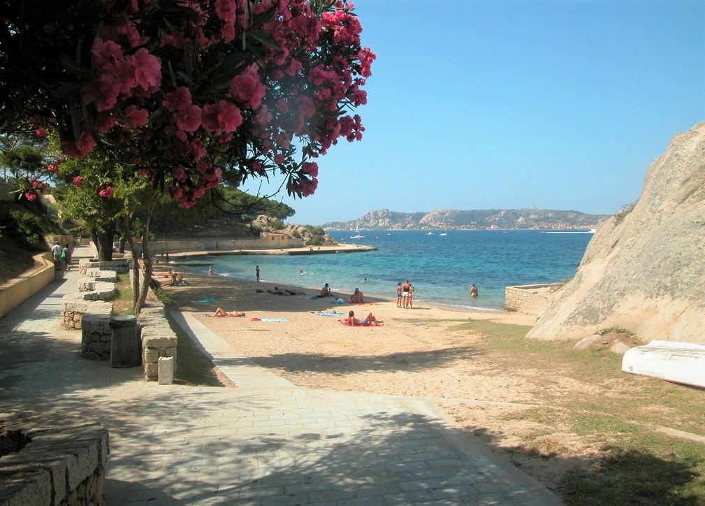
The final part of the old railway follows the coastline for a few metres, offering a view of the open sea, and then the tracks, now travelled along by the stretch of the Trenino Verde tourist train, carry on alongside the pine forest, a short distance from the beach. A few steps lower down, there is a ‘carpet’ of golden sand, framed by a magnificent promenade and washed by crystal clear waters. Palau Vecchio is unforgettable, with its picture postcard landscape, enchanting and a little old-fashioned. The inhabitants of Palau are most fond of this stretch of coast and it has received the Blue Flag award from the Foundation for Environmental Education (FEE) several times.
The beach is ideal for families with children, thanks to the shallow waters and sandy seabed, and the pine forest guarantees shelter from the afternoon heat, while its transparent waters makes it a suitable destination for snorkelling enthusiasts. It is accessible to disabled people, with a wooden walkway leading directly into the water, while there are bars and refreshment points nearby. The view in front of the beach is spectacular: the sea, reflecting shades of emerald green and blue on the horizon, makes way for the outline of Santo Stefano, and behind it the two largest islands of the Archipelago National Park, La Maddalena and Caprera. Beyond the pine forest, the beach of Porto Faro is just a few steps away, stretching along an inlet and dominated by a distinctive lighthouse. The sand here is fine and white, with pink granite rocks emerging. The Mediterranean greenery almost reaches the sea.
Palau Vecchio is not the only beach in Palau to boast the Blue Flag award: it is accompanied by Isolotto, a small beach next to the tourist port, with similar features to Porto Faro: white sand, rocky outcrops and sea with shimmering colours.
A few kilometres separate the city beaches from the symbol of Palau, a monument sculpted by Nature, an exceptional artist: it is the Roccia dell’Orso (Bear Rock), with its head facing the sea, used as a reference point by sailors in ancient times. In the opposite direction, to the west of the town, other ‘pearls’ of the Palau coast appear: Sciumara, characterised by its creamy-yellow sand, thick Mediterranean scrub and a deep blue sea, and Porto Rafael, one of the first exclusively tourist villages to emerge in northern Sardinia, where white houses scattered across the greenery stand out.
Spiaggia Bianca
Spiaggia Bianca is found at Spiaggia Bianca, in the commune of Golfo Aranci. The little bay, which stretches for a few hundred metres and which is occupied by a number of beach facilities, is sheltered by two rocky strips and also has a few dunes enhanced by wild lilies and low Mediterranean shrub. As well as the blue of its limpid waters, it boasts an enchanting panorama, with a view over the Island of Tavolara, the Golfo Aranci and over the whole coastline as far as Capo Coda Cavallo. The beach has extremely fine white sand, alternating with rocks.
Santo Stefano
It is the fourth largest island of the Maddalena Archipelago, the only one that has brought us evidence of prehistoric times and where the abandoned military constructions provide the best narration of centuries of events, from eighteenth century battles to shipwrecks, bombings, the ‘cold war’ and American marines. Today, the island of Santo Stefano is an unmissable stop during a tour in the La Maddalena Archipelago National Park and its western coastline is the main theme of the short ferry ride from Palau to La Maddalena. Its 3 square-kilometre expanse, the summit of which is Monte Zucchero (101 metres), is dominated by pink and white granite rocks, dotted with Mediterranean greenery, and the various roads branching off lead to the main points of interest.
The island has brought us traces of human presence dating back to the ancient Neolithic period (4th-3rd millennium BC), found inside a tafone: these were obsidian and porphyry objects, probably used for hunting. In the Middle Ages, several communities of monks found peace and isolation here and they built sanctuaries that have now disappeared. To the southwest of the island, stands the fort of San Giorgio, built in 1773 to protect the canal between La Maddalena and northern Sardinia. From here, Napoleon coordinated an attack on the town of La Maddalena twenty years later. Two small underground rooms were used as a prison or for storage, while on the square above there was a room and an armoury. Near the fort, you can visit the square tower, also known as 'Napoleonic', because the French general stayed there for a few days.
From 1972 to 2008, there was an American naval base in the eastern part of Santo Stefano. Today, a support base and a depot managed by the Italian Navy still remains. On the opposite coast, to the west, the Spiaggia del Pesce (Beach of the Fish) appears, with its fine white sand, crystal-clear water with blue and turquoise reflections and a shallow, sandy seabed. Opposite, surrounded by tiny coves, the Isolotto Roma stands out. This islet gets its name from a ship that sank there during the Second World War. South of the sandy shore, a granite promontory covered with Mediterranean scrub embellishes the landscape.
Next to one of the coves, Cala Villamarina, there is a granite quarry that was in use until the first decades of the 20th century. Here, you will see the impressive, never completed bust dedicated to Costanzo Ciano. The beach has medium-grain golden sand and pebbles. The southern stretch is characterised by the beaches of Punta Santo Stefano and Cala Levante, separated by a rocky spike and overlooking the coast of Palau. The emerald green colour of the sea contrasts with the pink of the rocks.
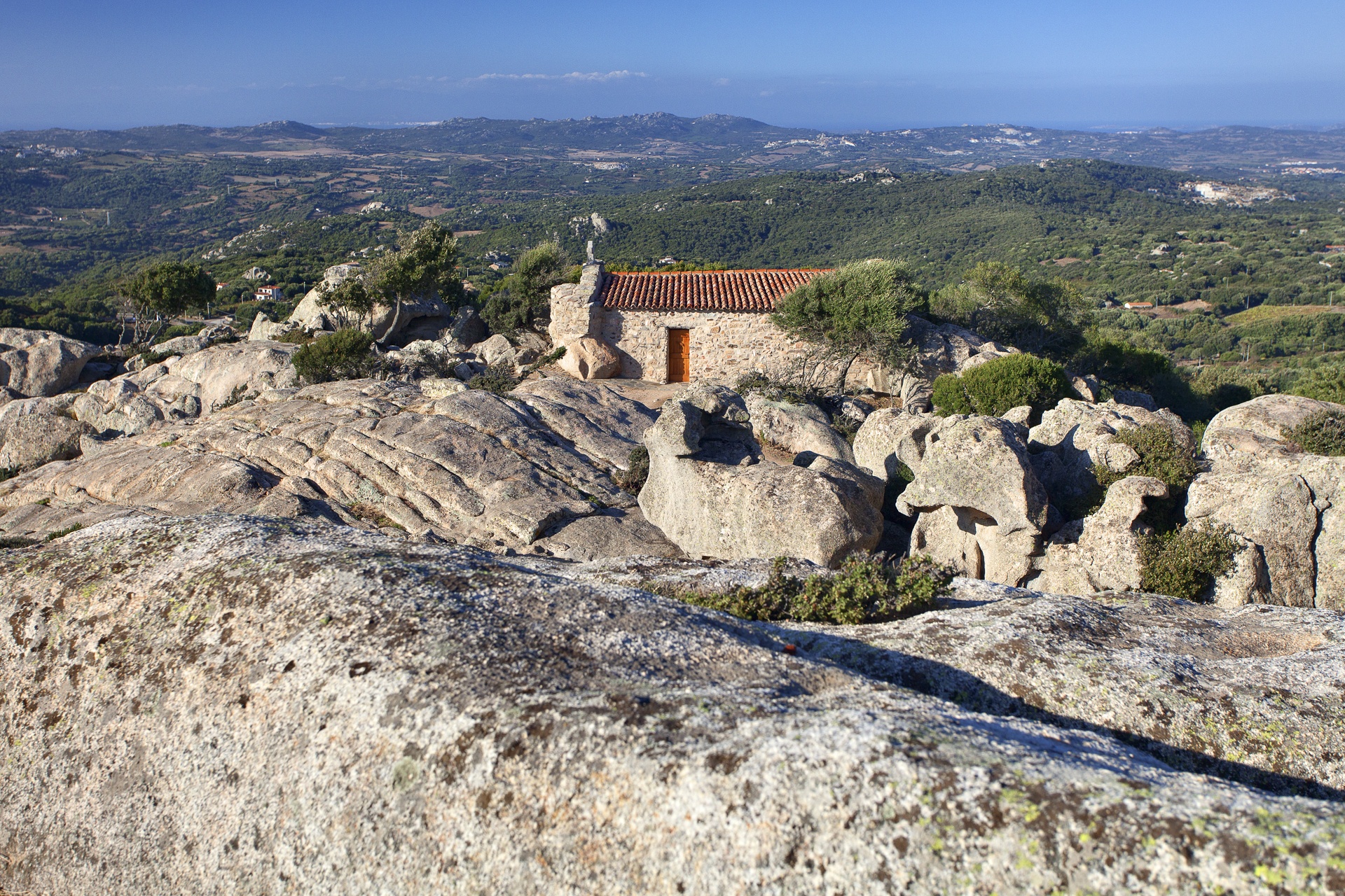
Eremo di San Trano
Giant rocks sculpted by the wind surround and protect a place of calm and silence that has always been a destination for worshippers seeking an intense spiritual experience. Less than half an hour's drive away from the island's splendid north-eastern coastline but far from its bustling activity is a small church surrounded by granite outcrops and Mediterranean brush, in a perfect example of Franciscan simplicity. The sanctuary is located to the south of Luogosanto, not far from the town, and its position offers a panoramic view over the Strait of Bonifacio. Nearly a thousand years of history is wrapped up in folk tales about the two protagonists of the origins of this mysterious, austere place. The Eremo di San Trano owes its name to two Anchorite saints, Nicola and Trano, who chose to live their faith to the full in this hermitage, far from comfort and sin, between the 4th and 5th century.
The sanctuary was built in the 13th century and is inextricably linked to a legend about the two hermits. In 1227, the bodies of the two saints were allegedly found by two Franciscan friars during a pilgrimage, guided by a vision of the Madonna who showed them the place where Trano and Nicola lived and told them to build the church. The small, rural building was erected around the granite cave where the two hermit saints took refuge. The cave was enclosed by the walls of the church, and took the form of a natural apse, almost "protecting" the altar, made from a block of granite, also "sculpted" by nature. The rest of the building is also in a simple, typically Franciscan style. The interior has a single nave with a few pews and flooring made from granite slabs. The roof has a double slope, with exposed wooden beams visible from inside, covered by rushes and protected by tiles. Behind the altar and under the ancient cave, you can admire the statues of saints Nicola and Trano, who are celebrated in early June with an evening procession and a huge banquet the following day.
The hermitage is one of the most popular destinations for pilgrims to Luogosanto, the "holy town", which has no fewer than 22 sanctuaries. The town itself owes its foundation to the arrival of the Franciscans, who built a convent there. Today, the renovated building hosts the Nativity della beata Vergine Maria Museum, which displays votive offerings to the Madonna Bambina over the centuries, to whom the church of Nostra Signora di Luogosanto is dedicated. In the 18th century the church received the privilege of a holy door: since the 1970s, the door has been made of bronze, by Luca Luchetti, and is opened for pilgrims for one year every seven.
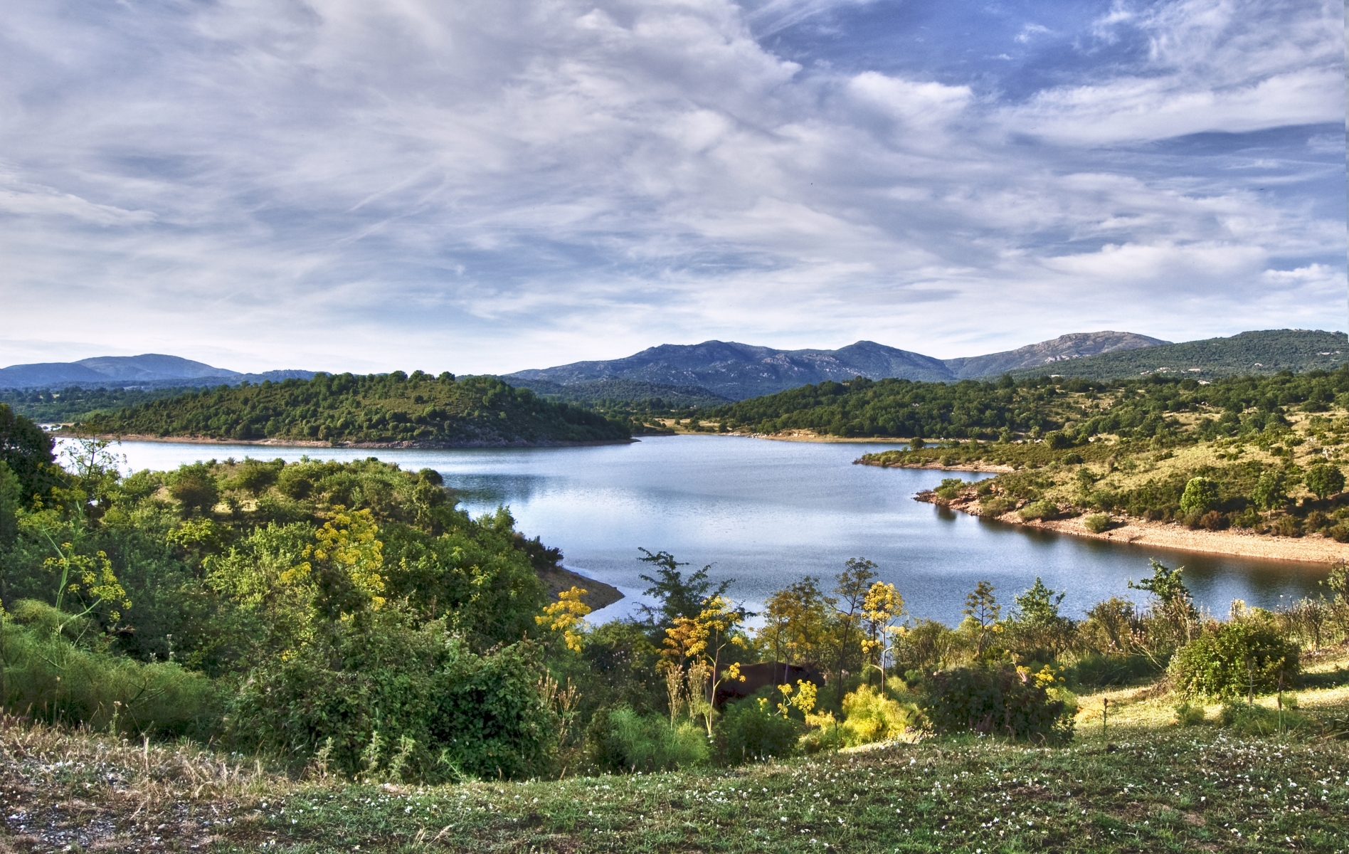
Coghinas
Set between the valleys of Oschiri, it is located on Monteacuto, at the entrance to the Gallura area, but within the province of Sassari. The lake of Coghinas collects the waters coming from the Rio Mannu rivulet and from the river of the same name. Its origin dates back to 1927 when, in the wild setting of the slopes of Monte Limbara, the barrage and the hydroelectricity power station were implemented on one of the greatest bodies of water of the Island, the Coghinas. The dam, which is 185 meters long and 58 metres high, dominates the end part of the basin, which has a capacity for 254 million cubic metres of water.
On the eastern bank of the gorge, you will notice an Art Nouveau style villa: it was the home of the director of the plant, which was later abandoned. From here, the lake opens up, following the route dictated by the mountains, bathing 18 square kilometres of territory. All around, valleys are dotted with Mediterranean scrub, holm oak forests and cork oak woods as far as the eye can see.
The winds are channelled through the mountain inlets creating a climate that suits the life of many plant and animal species: Largemouth bass, European perch, catfish, carp and Louisiana crayfish are the prey of those practicing recreational fishing. For bird-watching enthusiasts, various bird species offer exciting viewings. In the lake, nothing seems left to chance: you can do some trekking or mountain bike riding on trails along the river banks or, if you are seeking moments of serenity, you can enjoy the shade of holm oaks and cork oak woods either on foot or on horseback, following the paths by taking guided tours. On the subject of nature itineraries, near the lake, a trip to Su Filigosu is a must. This is a reforested area on the slopes of Mount Limbara, populated by deer, fallow deer and mouflons. To admire the environment of the lake 'from the inside', you can hire canoes or kayaks and reach vast inlets with smooth rocks. If, however, you want stronger emotions, you can spend your time doing some water skiing during trips to the lake. Every year, enthusiasts and curious visitors come to Coghinas to watch the high-speed jet skiing during the speciality Italian championships.
However, sport and nature are not the only things: for relaxing, there are the thermal and accommodation facilities a short walk from the lake, as well as restaurants and agritourism facilities where you can taste the delicacies of the Gallura area. To complete the tour, visit the old town centre of Oschiri, a splendid example of rural architecture, with narrow roads, paved in stone. Five kilometres from the village, in a territory dotted with Domus de Janas, tombs of Giants and nuraghi (can be visited), the church of Nostra Signora di Castro stands out: it was built at the end of the 12th century in Romanesque-Lombard style, and is striking testimony of Sardinia in the Middle Ages.

Brandinchi
It is also known as Tahiti. CalaBrandinchi is one of the most attractive and highly-frequented beaches, especially popular with international tourism, in Sardinia. It is located in Capo Coda Cavallo, almost opposite the impressive island of Tavolara, in the territory of San Teodoro. When you look at it, you will be struck above all by the light, almost dazzling colour of the sand. This intense white colour is a stunning contrast against the light blue turquoise water, with darker patches where rocks emerge, often a habitat for the rich marine wildlife. This stretch of sea is much-loved by snorkelling enthusiasts, because of the surprises it has in store for them every time they explore its waters.
Around the bay, there are well-kept gardens, a large pine forest and little dunes protecting a heavenly corner of the northeastern part of the Island. The beach also has a pier that welcomes small pleasure boats. History tells us that on 17 October 1867, after escaping from Caprera, Giuseppe Garibladi set off from here to free Rome, aided by the inhabitants of the place.
CalaBrandinchi is one of the most famous beaches in the whole of Gallura and is the brightest jewel in the San Teodoro area, which boasts numerous other beautiful gems along the coast. For example, there is the bordering 'sister' beach of Lu Impostu, another work of art, separated from each other by Capo Capicciolu. Slightly further south, separated by the promontory of Punta Aldìa, there is the curving beach of La Cinta, the symbol San Teodoro and five kilometres of fine, white sand dunes. On one side, there are the waters of the protected marine area and, on the inland side, there is the lagoon of San Teodoro. Further south, almost on the edge of the San Teodoro territory, you will find s'Isuledda that, with its beautiful beach and transparent sea, is as beautiful as all the other beaches.
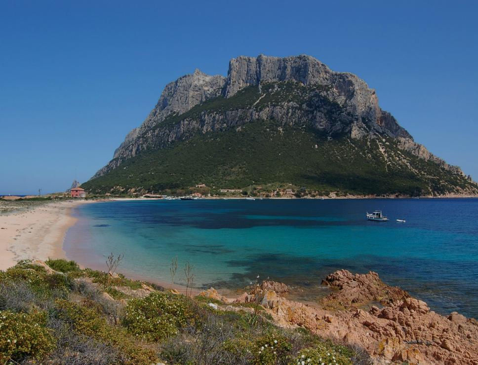
Tavolara
It is also famous for being the smallest kingdom in the world. Tavolara is a limestone and granite mountain that rises up from the sea, 560 metres high and four kilometres long, featuring rugged rocks and an impressive and vertiginous verticality. The island is part of the territory of Olbia and, in front of it, on the mainland, is Porto San Paolo, from which boats depart to reach the island. Its history is linked to King Charles Albert of Savoy who, according to legend, when he arrived on its coasts in search of the legendary goats with teeth of gold, which were probably yellow from eating helichrysum, named its only inhabitant, Paolo Bertoleoni, king of the island. His descendants are still the only residents (and guardians) on Tavolara.
In the eastern area of Spalmatore di Terra, where there is a little port, dining facilities and a small group of houses, you will find small beaches, fringed with sea daffodils. The entire territory is dotted with Mediterranean scrub, where the yellow helichrysum, wild geranium and a type of campanula known as "Stellina di Tavolara" (Little star of Tavolara) all stand out. Moving a little beyond the small port, onto its only plain, you will see the natural backdrop for Sardinia's most important film festival: Una notte in Italia (A night in Italy) has been taking place for decades, hosting actors, film directors and spectators in an unparalleled setting.
Tavolara, particularly the southern area known as Teddja Liscia, and the nearby islets of Molara and Molarotto, which belong to the Tavolara Marine Protected Area - Punta Coda Cavallo, are a paradise for scuba divers: environments rich in biodiversity and populated by schools of trusting fish offer unforgettable sights, both for divers using breathing apparatus and also for guided snorkelling.
Punta Tegge
At the south-western extremity Maddalena Island, shielded by a majestic granite cliff and a promontory crowned with the Santa Teresa Fort, is a beach graced with intense colours that takes its name from the characteristic water-worn rocks, rocks once used as roofing for houses. Punta Tegge is one of the most popular beaches of the largest island of the archipelago and faces Spargi and Porto Rafael.
This lovely beach is modest in size and connected to other, smaller, stretches of sand. Its golden sand is coarse-grained and surrounded by rocks that the wind has sculpted into gracious shapes. The water is a blue-green and the sea bed is almost immediately rocky and deep, making it a favourite of divers and underwater fishing enthusiasts.
The beach has water sports equipment rental facilities and a restaurant. The Santa Teresa Fort, also known as Sant’Elmo Fort or Tegge Fort, is nearby. Built in 1793 by Piedmontese-Sardinians, it stands on a hilltop from which you can enjoy gorgeous views of much of the island and the archipelago.
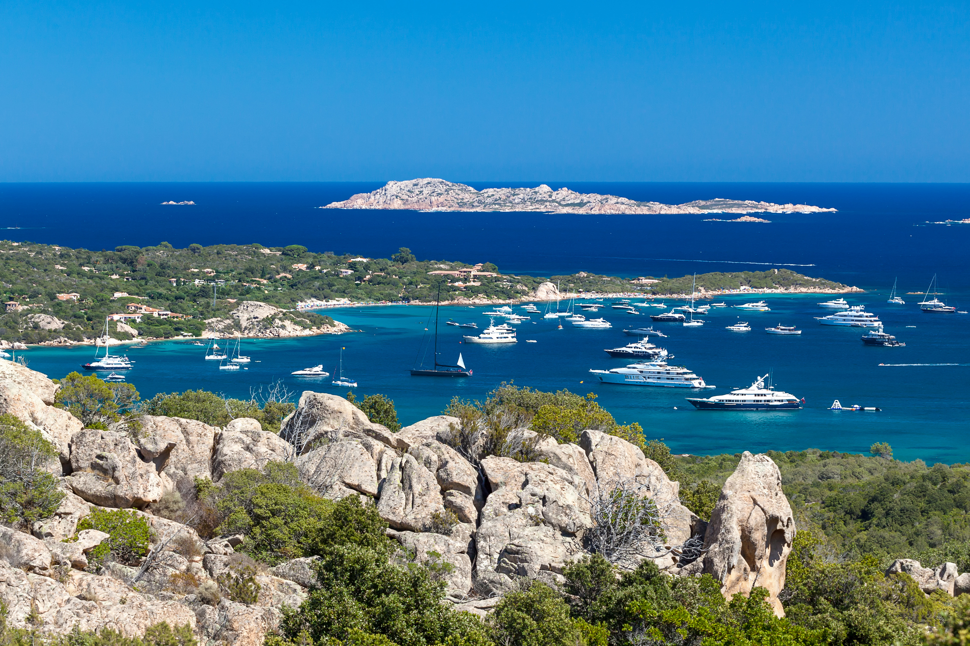
Tegge is only one of the many marvels you will find along the Maddalena coastline, which includes 45 km of cliffs, inlets and coves. As you follow along the shoreline of this south-western part of the island, you’ll come across other unforgettable places, like the fascinating Nido d’Aquila and, further up the western shore, Cala Francese, with its quiet bays and dreamy beaches. In the north you’ll find rocks shaped by the wind and beaches of white dunes like Bassa Trinita, with its fine sand and framed by granite cliffs, or Cala Lunga and Monti d’a Rena. To the east, just past the isthmus that connects Maddalena to Caprera, is Spalmatore, with its lovely landscape. You can go explore the other islands of the national park - Santo Stefano, Budelli (with its celebrated Pink Beach), Razzoli, Santa Maria and Spargi – from Maddalena Island.

Budelli
Even from afar, it displays its entire beauty with sensational colours. Budelli is one of the brightest gems of the Maddalena Archipelago, famous for its turquoise waters and for the Spiaggia Rosa, the Pink Beach, one of the most beautiful beaches of the Mediterranean. Its pink colour is derived from ground shelled microorganisms called Miniacinia miniacea, that live among the posidonia and are transported to the beach by the currents. At Cala Roto, where the beach is located, in 1964 Michelangelo Antonioni shot the scene of the girl’s fable in “Red Desert”, capturing the nature of this place in its full spontaneity. Formerly private property. Budelli became part of the national park in May 2016. Today, protected by environmental regulations, you can admire it from afar as a masterpiece of nature, accompanied by the park’s guides, without setting anchor, swimming in the sea or even stepping on the beach. Even from afar, the island is fascinating. Together with Razzoli, Santa Maria and nearby Spargi, it makes up the wildest part of the archipelago. It totals 12 kilometres of coast and a territory of 25 hectares, inhabited solely by the island’s custodian.
The view from the top of Mount Budello (87 metres) is breath taking: granitic rocks and lush vegetation hide coves of fine sand and blue sea, such as the Spiaggia del Cavaliere beach to the northeast. It is a marvellous cove of light, impalpable sand, embraced by golden and pink rocks covered by the scented Mediterranean scrub. The sea that bathes it is of an almost impossible blue. No wonder it is also called “the Madonna’s port” (or mantle). Behind the beach there is a pond populated by little egrets, herons, coots and mallard ducks. The “Cavalieri” are protected as well: boats are not allowed nearby, but you can set anchor from afar, within a delimited area.
To get to Budelli, try a guided tour and rent a boat leaving from the Emerald Coast, La Maddalena, Palau and Santa Teresa Gallura. The seabed of the entire archipelago, also known as cetacean sanctuary, is perfect for diving. Do not miss the Washington shallows between Budelli and Spargi.
Isola di Mortorio e di Soffi
The environmental protection of these islets falls within the prerogatives of the Arcipelago di La Maddalena National Park. However, the two islets, along with a third called Le Camere, make a small archipelago of their own, which is part of the treasures of the Costa Smeralda. The island of Soffi is in front of the beach of Capriccioli, while the island of Mortorio, the largest of the group, lies in front of the Romazzino coastal road. Both are of granite origin. The first has a surface area of 40 hectares and the second of 60. And both are integral reserve areas, subject to maximum protection: they can be admired at a safe distance from their coasts, within an accessible marine belt and with the authorization of the park authority. In fact, they preserve uncontaminated ecosystems, enriched by marine fauna and rare species of birds that nest, especially on the coasts of Mortorio, such as the Corsican gull and peregrine falcon. In order to discover them, it is first necessary to ascertain the park authority's conservation rules.
Soffi is flat and not very indented, without any large inlets but with four delightful little coves, which are real natural pools surrounded by pink rocks. The little beaches have coarse-grained sand and small pebbles, while the seabed is sandy and the sea is crystal clear. Waters around the island can be navigated only within a limited area, through guided tours from Portisco, Porto Cervo or Porto Rotondo.
Mortorio, unlike Soffi and Le Camere alongside it, is precipitous with steep cliffs that reach heights of up to 80 metres, featuring low vegetation of Mediterranean scrub and broom shrubs. It is divided into two parts by a strip of land and dotted with small coves with beaches that are sheltered, thanks to their position, and with waters are almost always calm. Access to boats and disembarkation on the islet is totally forbidden. On it, however, the past traces of the passage of man are evident. It was inhabited for a few years by Genoese settlers, who then moved to Tavolara.