
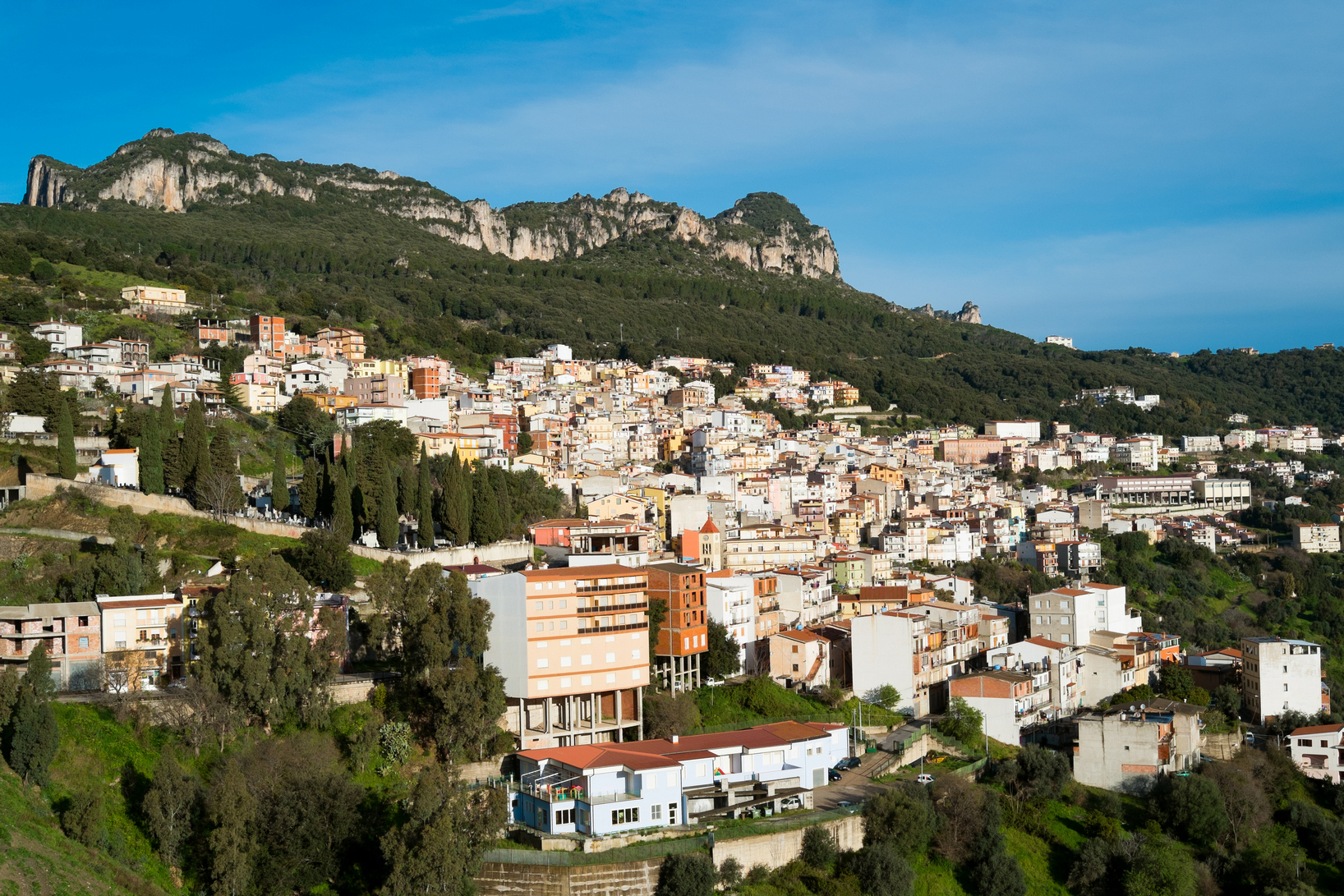
Jerzu
An ancient village in the south-western part of Ogliastra sits at an altitude of 450m above the sea in the rio Pardu valley, encircled by the unusual rocky formations of the high plains: the amazing Porcu ‘e Ludu and Troiscu outcrops. Jerzu is home to about three thousand inhabitants and its steep streets rise upwards over various levels to reveal gorgeous views. The surrounding areas boast peaks with steep walls ideal for free climbing and paths for hiking (or even mountain biking) in the pristine nature provided by woods of oak and maple trees, of myrtle bushes and Spanish broom, of fig, chestnut and almond trees. A network of streams waters vegetable gardens and orchards, the scenery is graced with bare hills skirted by olive groves, cultivated fields and, above all, vineyards that pan out as far as the eye can see, especially in the Pardu and rio Quirra valleys and the Pelau plains. Hundreds of tons of grapes are harvested here every year to make cannonau, the famous red wine that has made Jerzu a City of Wine. The town’s winemaking cooperative came about in the mid-XX century and is well worth a visit. The name Jerzzu shows up in official documents for the first time in the year 1130, when a donation of vineyards was registered. In the XVI there was mention of ‘wine roads’, for the wine was already being exported to beyond the Alps. Early August includes two important events devoted to cannonau. During the sagra del vino, or wine festival, the ancient carts used during the grape harvest parade through the streets alongside locals clad in traditional dress as onlookers are regaled with island folk music and sample the wine. Traditional fare like culurgiones and coccoi prenas is also a must! One of the events during the festival is the Calci sotto le Stelle, or Chalices under the Stars, when after sundown you can stroll from one historical cantina to another sampling their best wines listening to the traditional music of the tenores and launeddas. Other delicacies include su pani conciu (bread soaked in wine) and is tacculas (myrtle flavoured biscuits). There is a new nature museum in town to raise awareness of (and safeguard) the environmental heritage of the area. And then there is the archaeological legacy. The first settlements here date to Neolithic times: the domus de Janas at Perda Puntuta and sa Ibba s’Ilixi. The thirty or so Nuragic settlements that include the s’Omu ‘e s’Orcu were built in subsequent eras. The top of Mt. Corongiu rises to a thousand metres and is Jerzu’s most panoramic spot. There are traces of a Punic necropolis here. And then there is art, the Stazione dell’arte of Ulassai is located in the old train station and houses works by the internationally renowned artist Maria Lai. Jerzu is also a city of theatre, home of the Ogliastra Teatro festival. The feast of St. Antonio da Padova is the most heartfelt of the religious festivals and takes place on June 13, when the simulacrum of the saint is brought down in a procession leading from the upper reaches of town to the small country church that bears his name, in a lovely setting surrounded by Tacchi, or rocky outcrops.
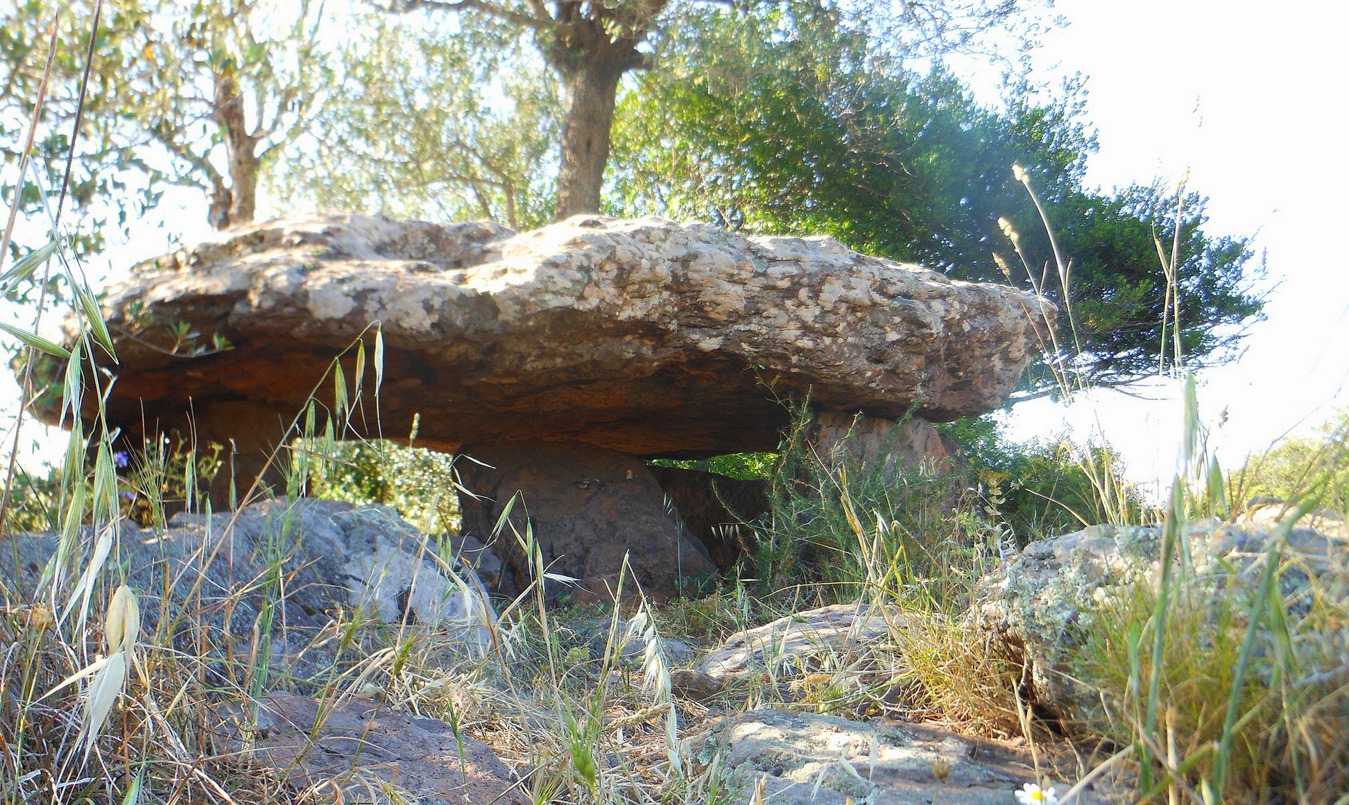
Dolmen of Motorra
About five thousand years ago, it was completely covered with earth, to protect the repose of the deceased inside it, while today it reveals its charm and the distinctive trait of being one of the very rare corridor dolmens in Sardinia. The tomb of Motorra is located on a plateau in the territory of Dorgali, about 200 metres above sea level and just over two kilometres from the residential area. It has a hexagonal layout, it is built entirely from basaltic stone, with walls made up of eight rectangular slabs, and is covered by a single unevenly shaped slab.
You can go inside via an entrance that still has a manhole cover, albeit fragmented, and then you can continue along the corridor. The space is made up of four orthostats and was originally covered by three slabs, now no longer in situ. The dolmen is surrounded by a ‘peristalite’, a circle of stones, with an oval shape. Eleven slabs are still standing and their function was to support the mound of earth and stone that covered the tomb. To the north-west of the dolmen you will notice three other slabs standing upright on the ground, the function of which is still a mystery. For some, these are the remains of a reinforcement wall on the side most exposed to the elements, while another theory suggests that there were really two circles of stones, with an outermost circle enclosing the first, which in turn contained the dolmen. The oldest materials found in Motorra date back to the Ozieri culture, i.e. the Final Neolithic period, between 3200 and 2800 BC, while the last period of its use appears to be between 1800 and 1600 BC.
The southwestern slopes of the limestone ridge of Monte s’Ospile, where the tomb stands, are dotted with prehistoric evidence: a short distance away are the Mariughia and Pistiddori dolmens and the settlement of Neulè. The sanctuary-village of Serra Orrios, with around a hundred huts, two megalithic tombs and two sacred areas, each with a megaron temple, dates back to the Early Bronze Age (16th century BC). The Giants’ Tomb of s’Ena e Thomes, which is contemporary and not far away, is one of the largest and best preserved. The most fascinating archaeological site from the point of view of the landscape, is the nuraghe Mannu, a single-tower type made of vulcanite and basalt, overlooking the sea of the Gulf of Orosei. You can get to it via a detour along the road to the seaside village of Cala Gonone or along a path from the beach of Cala Fuili. If you then want to add a further natural jewel to your itinerary, a panoramic trek of an hour and a half will take you to Cala Luna, an inlet with golden sand, set between the cliffs and washed by the blue sea.
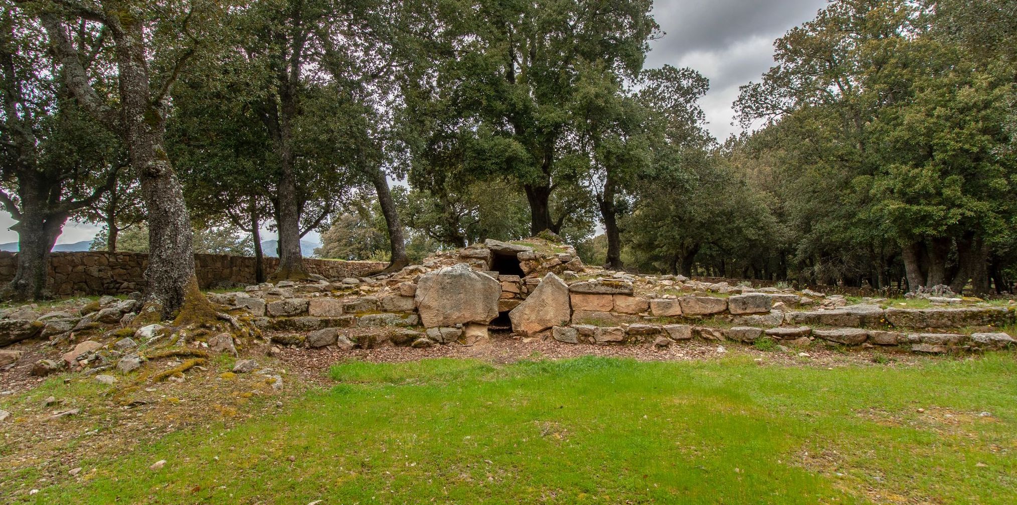
Giants' Tomb of Troculu
The archaeological patrimony of Villagrande Strisaili is a continuous and surprising discovery that deserves special attention. One of its gems is eight kilometres from the hamlet, that almost has the same name, of Villanova Strisaili, on the border between Ogliastra and Barbagia di Belvì. It is the Giants’ Tomb of Troculu, which appears among the shrubs in the Mediterranean scrub, once used for the veneration of the dead inside a large Nuragic complex and now an archaeological site, consisting not only of the tomb, but also of the remains of two nuraghi and of what was once the settlement’s village of reference during the Bronze Age. In reality, the site of the tomb today is not its original location. Due to the construction of the Nuoro-Lanusei expressway, the tomb was dismantled and reassembled nearby at the end of the 20th century. You will see that the body of the tomb is still intact. It was made using granite blocks positioned in uneven rows and shaped obliquely on the exposed face. You will notice the typical use of supporting wedges between the rows.
The tomb of Troculu is in an ideal position within a fascinating Nuragic itinerary, which includes the sanctuary of s’Arcu e is Forros, with a majestic megaron temple, probably dedicated to the worship of the waters and surrounded by a sacred enclosure. Nearby, you’ll see traces of metalworking furnaces, huts and a trefoil nuraghe. To the east, on the other hand, lies the area of sa Carcaredda: the complex includes a temple in antis - consisting of a vestibule, a circular room and a room next to the vestibule -, a village and four Giants’ Tombs, two of which are well preserved.
The three complexes of Troculu, s’Arcu ‘e is Forros and sa Carcaredda are surrounded by magical landscapes, where nature has given proof of its artistic flair. Here, you’ll find the natural pools of Bau Mela, dug out of the granite, and the forest of Santa Barbara with centuries-old trees, medicinal and aromatic plants, Mediterranean scrub, springs and waterways. Crossing the park and travelling alongside the upper Flumendosa lake you will come to another enchanting sight: the gorge of Pirincanes and the waterfalls of Rio ‘e Forru. Here, the torrent has eroded the pink granite, creating a canyon and giving rise to waterfalls that, in turn, generate pools of crystal clear water, called ‘cauldrons of the giants’.
Sa Carcaredda
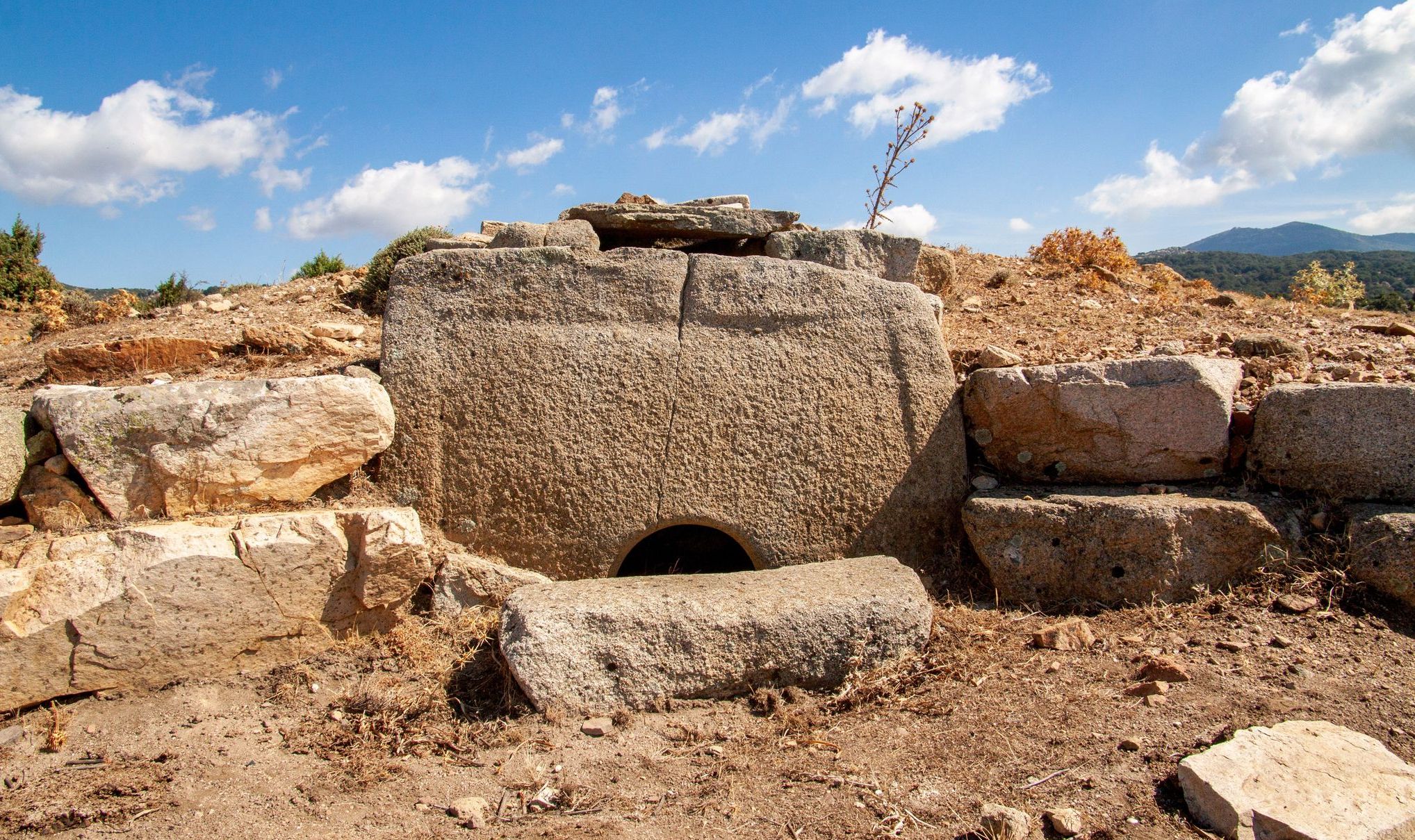
A mysterious, mystical, almost surreal atmosphere surrounds Sa Carcaredda, an archaeological complex hidden in the middle of a holm oak forest, on the border between Ogliastra and Barbagia, in the territory of Villagrande Strisaili, not far from the shores of the lake in Alto Flumendosa. In the site, frequented since time immemorial, there are the ruins of the monuments and traces of the daily life of the Nuragic peoples who lived here during the Bronze and Iron Ages. The evidence they provide are a temple in antis, a large village and four Giants’ Tombs, and they have a distinctive trait, seemingly appearing to be without nuraghe or nuraghi of reference. The dimensions of the religious building and the tombs, along with the large number of votive artefacts found in the area - probably used as a storeroom - show the importance of the settlement, both from a religious and a commercial point of view and, in general, the complexity of the Nuragic world in Ogliastra.
The temple, made from uneven blocks of granite and porphyry, is divided into a circular room preceded by a quadrangular vestibule. Inside, you will notice some original elements: a bench-seat for the worshippers and ministrants and granite slabs as flooring. The ‘heart’ of the building is the circular chamber, originally with a tholos ceiling (false vault). Here, a ceremonial hearth was delimited by a wall made of limestone blocks, externally decorated with ashlars imitating the bastions of Nuragic towers. The structure, now on display at the archaeological museum of Nuoro, served as an altar and contained the numerous votive artefacts, largely made of bronze, found during the excavation campaigns. Around the temple, you will see circular and rectangular traces of other spaces, perhaps relating to the village huts, which are still being investigated.
To visit the two best preserved Giants’ Tombs, you will walk among the holm oaks. The formidable stele of the first one lies fragmented on the ground near the tomb, which has a burial chamber twelve meters long and is still intact, made of granite blocks, above which there are flat slabs positioned as a flat arch. The second tomb is about 300 metres away and has an exedra with orthostates attached to the ground.
Continuing the Nuragic tour, moving in a northwesterly direction you will find further fascinating evidence of ancient sacredness: the village-sanctuary of s’Arcu e is Forros, with a three-lobed nuraghe and three temples dedicated to the worship of the waters. Next to one of them, which is of the megaron type, you can admire two circular structures, considered to be ovens. The itinerary of the Nuragic areas of worship ends to the north of Lake Flumendosa with the Giants’ Tomb of Troculu, with its tomb body still intact.
Ulassai
With a high percentage of people renowned for their longevity among its 1500 inhabitants, it contributes to one of the world’s five Blue Zones. Ulassai lies in the most inland part of the province of Ogliastra, at an altitude of almost 800 metres, between the limestone buttes with their slopes covered in evergreen forests in which the Wildlife Oasis of Girisai is located and where spectacular caves open up, like that of Is Lianas. Above all, there is Su Marmuri, 'the marble': you can walk for 850 metres through the rooms with high walls, little lakes and stalactites that join with stalagmites to form huge columns. To reach one of the most impressive in Europe, you can walk along paths amidst deep gorges, which are the destination of free climbing professionals. Underground waters emerge from the grottoes and, beneath Su Marmuri, they form the Lecorci Waterfalls, which gush wildly from smooth rock faces. The waters flow to meet the Lequarci Waterfalls, the biggest on the Island, with a drop of almost one hundred metres and a maximum width of 70. Downstream, there is a myriad of small lakes in the locality of Santa Barbara. Here, in the forest, you can visit a little Byzantine church. Around it, there are Is Cumbessias, which acted as lodgings for the pilgrims during celebrations dedicated to the saint. Still today, the celebrations most heartfelt by the Ulassai community take place at the end of May, with a procession, accompanied by launeddas and folk groups, a feast in which you can taste the local delicacies and a poetry contest.
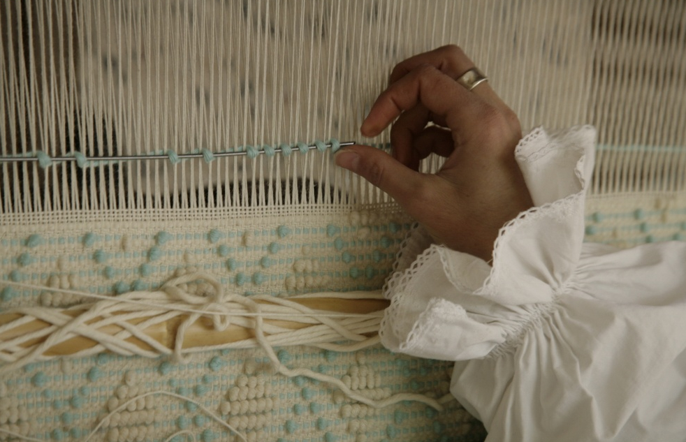
The village is an open air museum, in harmony with architecture, nature and works of art. Creating an even lovelier atmosphere is the Stazione dell'Arte (Art Station), in which you will find the 'multifaceted' genius of Maria Lai, the most famous citizen of Ulassai. Before the advent of the railway (1893), the village was connected to nowhere outside of Ogliastra. This isolation led to the preservation of ancient traditions, like the use of the horizontal loom, the artisan production of cheeses and hams and bread-making in wood-burning ovens: there is one in every house. To the east, the valley of the Rio Pardu river is cultivated with olive groves and vineyards where well-known olive oil and Cannonau wine are produced. Strawberry tree honey and typical local dishes like culurgiones a ispighitta and coccoi prena are also famous. On All Saints Day, there is the collection of alms of Is Animeddas, which is similar to Halloween. Su Maimulu is the famous carnival in Ulassai, which begins on St Sebastian's Day (20 January). The theatrical festival of the Tacchi (Buttes) is very popular. In the territory you will find endless evidence of prehistoric times. The most important is the Nuraghe S'Ulimu (1500-900 BC), at an altitude of 700 metres: two massive towers joined by a thick curtain wall. It is located near eight Domus de Janas, a Dolmen, three Tombs of Giants and three Nuragic villages. The Nuraghe Pranu, the complex of Nuragheddu, the fortress of Seroni and the megalithic village of Seddorrulu are also well-preserved.

Su Sterru – Il Golgo di Baunei
Its vertiginous height of 270 metres makes su Sterru Europe’s deepest single-span chasm. Formed in the heart of the Golgo plateau (400 metres high), within the Baunei territory, the chasm is a place filled with mysteries and ancient legends that will give you goose bumps: according to legend, it was once a snake’s lair (su scultone), whose menace was warded off by the building, in the 17th century, of the church of San Pietro nearby. The cavity is actually the habitat of the tame Sardinian cave salamander, an amphibian adapted to this location, accompanied by the porrohomma spider and a few terrestrial crustaceans. The chasm was initially believed to be a volcano (in old topographic maps it was identified as “Old Crater”) 100-150 metres deep, but its complete exploration, in 1957, revealed the enormous karstic abyss created by erosion. Sterru, in fact, means both “descending slope” and “pit”, and is a term commonly used to other place names in Ogliastra and Barbagia. Today, it is only explored by experienced speleologists.
The chasm opens suddenly on the plateau, 13 kilometres from the town of Baunei. The mouth of the chasm is made of dark basaltic rocks, while the inner part is formed by white limestone. Its 25 metres of diameter increase to 40 in the bottom. It can be reached on foot my crossing a fascinating landscape: lava flow on limestone, ferns and holm oaks covered in moss, small ponds (piscinas). It is an open-air museum: wells to celebrate ancestral rituals, domus de Janas, which attest to human presence since the Neolithic, Giants’ tombs and almost twenty Nuragic complexes, placed as sentinels at the accesses to the valley. A complex network of fortresses built after 1500 BC: it feels like a walk through pre-history.
From the Golgo plateau, you get to the Bacu Canale forest and Pedra Longa, a 128-metre pinnacle over the sea. After three and a half kilometres of trekking, you will get to the enchanting Cala Goloritzè. If you would rather face a longer itinerary, leave from the little church of San Pietro to get to codula di Sisine, a calcareous valley with high walls and groves of ancient holm oaks, leading to the splendid beach of Casa Sisine.
Bari Sardo
The name of this town dates to 1862, when King Vittorio Emanuele added ‘Sardo’ to what was then simply Barì to avoid confusing it with the capital of Apulia of the same name. Bari Sardo sits surrounded by hills covered by vineyards and orchards on the lovely basaltic high plain of Teccu ‘e su Crastu. It is renowned for its textile crafts: rugs, tapestries, blankets and linens. The town’s origins date to the High Middle Ages, when people moved here, four kilometres inland from the coast, to escape the incursions of Vandals and Saracens. The area of Barì was under the jurisdiction of Cagliari until 1258, when it was annexed first by Gallura and then by the Republic of Pisa. In 1324 it was encompassed into the Kingdom of Sardinia and then, in 1861, became a part of the Republic of Italy. Some four thousand people live here today.
The centre is graced with rustic houses, colonial villas, Spanish towers, old sheep folds and the grand parish church of Nostra Signora di Monserrato, one of the island’s most beautiful churches, rich with precious marble. There are a variety of other churches that are also well worth a visit: the church of Santa Cecilia, which was originally a country church but now encompassed by the town, the church of San Giovanni, in sa Marina where every year there is a religious procession from the town to this outskirt, and the country church of San Leonardo (XVI century). The region is dotted with archaeological remains: the domus de Janas at Pizzu ‘e Monti and Funtana su Rettore, 14 nuraghes, the most famous of which is Sellersu and the giant tombs of Canali, Uli and Pitzu Teccu. In Roman times there was a presidium called Custodia Rubriensis, named after the early Sardinians (Rubrensi) who had settled here.
The symbol of Bari Sardo is the torre di Barì, a tower constructed on a rocky outcrop over the sea by the Aragonese between 1572 and 1639. It is about 13 metres high with a base that measures 11 metres in diameter and controls the 15 kilometres of shoreline between Bella Vista and Sferracavallo. The fortress dominates and divides the shoreline into two parts: to the north the mari de is ominis, to the south the mari de is feminas, in keeping with a distinction made just after the war when the north was designated for use by men and the south for women. South of the beach of Torre di Barì is the quiet beach of sa Marina Tramalitza, with beige sand and crystalline water with a soft green hue. One of the gems of Ogliastra is located within the confines of Barì: Cea, a kilometre of soft white sandy beach, shallow water, smooth rocks and an emerald sea. Three hundred metres from shore, at the centre, are 2 twenty metre high rocky stacks know as the is Scoglius Arrubius, the symbol of Cea.
Scala di San Giorgio
“While traveling he came to a mountain where there was a road that could have been shorter and straighter when passing through” The Legenda sanctissimi Georgii presulis suellinsis, a hagiographic document of 1117 on the life of San Giorgio, the first bishop of the diocese of Barbaria, tells us that, during a pastoral visit to Osini, he reached the foot of an inaccessible mountain. Tired from his journey and thinking about the hardships of the wayfarers, the Saint prayed that a passage would open up to make the journey shorter and easier. Nearby, he also caused the spring of s'abba de sa santidade (water of holiness) to appear – now a destination for pilgrimages – to further alleviate the fatigue of the wayfarers. In the 14th century, in honour of the ‘miracle’, the inhabitants of Osini named a small church at the foot of the mountain after him. Thus, according to legend, the Scala (Staircase) di San Giorgio was created, also known as the Gola (Canyon) or the Arco (Arch) of San Giorgio, recognised as a natural monument in 1994. It is located 900 metres above sea level along the rock faces that delimit, to the east, the large limestone-dolomitic taccu of Osini which overlooks the village that ‘lived’ twice.
Skala indicates a steep and bumpy passage across the ridge of an elevation, in this specific case a six kilometre-long pass connecting the valleys of the Pardu rivulet, to the northeast, and the Flumineddu rivulet, to the southwest. The narrow canyon, created from a fracture on the edge of the plateau and delimited by 50-metre high looming rock faces, has a unique detail: it is crossed by a strip of asphalt beginning in the village, making it easy to visit. The whole place features perfectly vertical walls, magnificent fractures and incisions in the rocks. The most impressive is sa Brecca ‘e Usala, that vertically crosses the canyon and is almost one hundred metres deep. Going back up along the walls of sa skala, which are close to each other, at the end of the asphalt strip, a little trail interspersed with steps will allow you to reach the peak of the taccu of Osini an isolated environment covered in holm oaks. The highest point (almost a thousand metres) is s’Assa de su Casteddu (castle wall), a place name that led to speculation about the existence of a medieval fortress here. In reality, it is more likely that there was once a Roman-Byzantine military post here, as is confirmed by the discovery of coins and pottery from that period.
From up there, the view is awe-inspiring: it dominates the whole of the Ogliastra region, as far as the sea, including the uninhabited houses of the ‘historical old town of Osini’, abandoned after the floods in 1951. The new town emerged higher up and is embellished with works of art by Maria Lai, Costantino Nivola and Pinuccio Sciola. After crossing the pass, you will be taken to the valle di Taccu nature and archaeological park. The most majestic proto-historic heritage is the nuraghe Serbissi, consisting of a central tower and three corner towers. Other nuraghi placed to guard the area have similar architectural features. In the heart of the Valley, you will find the ‘twin’' nuraghe Orruttu and Sanu; an nearby, the remains of a Tomb. of Giants. Near the ‘scala’, but in the territory of Ulassai, there is another natural monument: the spectacular su Marmuri cave.
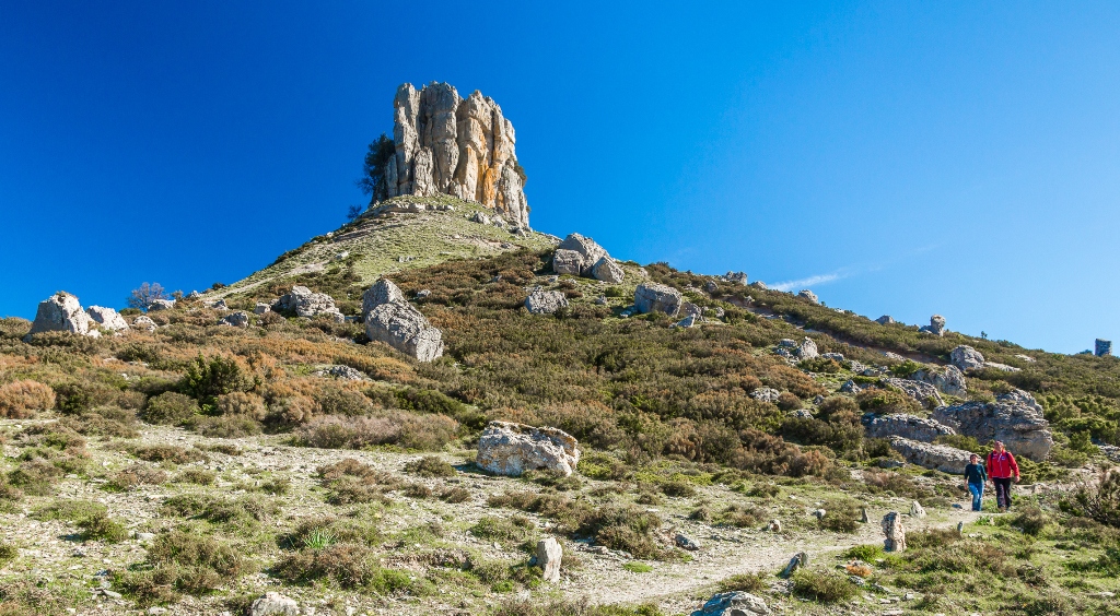
Perda 'e Liana
At one time, it may have been a meeting place for Nuragic populations and then, according to popular legends, it became the entrance to the Underworld. It emerges from the earth like a gigantic finger stretched towards the sky and is a reference point, visible from a great distance, for hikers in a wild territory. Perda ‘e Liana is an extraordinary rocky formation declared a natural monument in 1993. The unusual ‘mount’, known as taccu or tonneri in Sardinian, stands out in the territory of Gairo Sant’Elena: it is the greatest piece of evidence of the erosive action of the weather, which lasted tens of millions of years, on an extensive limestone covering in the Ogliastra area on the border with Barbagia of Seulo. The erosion progressively isolated the ‘tower’ and shaped its base. It is the highest (1293 metres) of the numerous buttes in Ogliastra, northern extremity of the plateau of Tonneri, about two kilometres away, which connects with the saddle of s’Arcu ‘e su Pirastu Trottu. In the distant past, they may have formed a single mountain ridge.
Perda ‘e Liana has a composite profile. In the upper part, it consists of a majestic cylindrical limestone-dolomitic crag, with a diameter of about a hundred metres and with a streamlined shape. Its sub-vertical walls, 50 metres high, are divided into regular-shaped blocks and their light colour makes them stand out against the dark landscape. The summit of the taccu originated in the Jurassic era (130-150 million years ago) following long sedimentation in an underwater environment, as is shown by the marine fossils scattered around it. The base has a truncated cone shape, it stands on the plateau of Pranedda and it is composed of Mesozoic sandstone. It overlaps a compact base of Palaeozoic schists.
The name liana may come from the characteristic smoothness of the rock or from olione, strawberry tree, that covered its slopes. Otherwise, it may have come from the Ilienses, Nuragic people, who met at the base of the limestone peak. Not surprisingly, the mountain is clearly visible at a great distance from the major Nuragic settlements of deepest Ogliastra - s’Arcu e is forros, Ruinas and Serbissi - and it is a reference point for people doing trekking in the area, amidst woods of holm oaks and shrubs in the Mediterranean scrub. As you get closer to the top, the trees disappear and the ‘low’ vegetation thins out until it almost disappears, like at Texile in Aritzo. In an area ideal for hiking, you can follow a network of marked trails, accompanied by guides, starting from the barracks of Montarbu, one of the most enchanting Sardinian forests, as well as a wildlife oasis, where the green Trenino Verde tourist train stops. Caves and sinkholes open up in the nearby karst plateaus, among which su Stampu.
The mountain, considered almost like a totem pole in Antiquity, became the protagonist of popular legends, perhaps as early as pre-Christian times. It was said that the door of Hell could be found in the taccu: in popular imagination, devils would come out and dance around it in the moonlight, ready to give all the riches of the world to those who went there, in exchange for their souls. Hence the following sayings: “He went to sell his soul to the Devil at Perda Liana”, “they give you what you ask for there”. To verify the ‘truthfulness’ of the legends, you can get there from several points and roads: from Gairo and its hamlet Gairo Taquisara, from Villagrande Strisaili and from Seui along state road SS 198, taking the mountain road that leads to the Flumendosa lake. From the rest areas, both to the north and to the south, you will reach the taccu from pedestrian paths of about one kilometre. You can also take a circular path around the Perda. The climb (recommended) starts from Arcu de su Pirastu Trottu and, with a height difference of 340 metres, reaches the base of the tower. You can climb fairly easily up to the halfway point, going beyond a grade three passage. The climb up to the summit is the dominion of rock climbers only.
Arvu nuraghic area
The village lies on the slopes of Monte Bardia, not far from the coast in the centre of the Gulf of Orosei. This nuraghic settlement is made up of about 100 circular-plan huts, built of limestone blocks. One of these houses seems to be the meeting hut: it is circular with a wide entrance leading into a chamber with double benches and three niches in the walls. A great circular fireplace marked off by upright slabs is set near the entrance.
From Nuoro, take SS 129 and continue until you reach the turnoff for SP 38. drive along it until you come to the crossroads with SS 125, in direction of Dorgali. Drive as far as the town and then take SS 125, known as the 'Orientale Sarda' until the turnoff for Cala Gonone. Just before reaching the town, in the vicinity of a gas station, take a left turn, and drive up the hill which hosts a modern residential development. at the end of the road, turn right and drive a short distance until on the left you come to an uphill pathway with a tourist sign indicating the nuraghic village. Leave the car and walk along the path until its end: the ruins of the hut village are on the right, amidst the thick Mediterranean maquis.
Phone: +39 0784 927200/36 - +39 0784 96721 - +39 338 8341618 - +39 349 442552/3/4/8
Website: www.dorgali.it - www.ghivine.com e-mail: ghivine@tiscalinet.it