
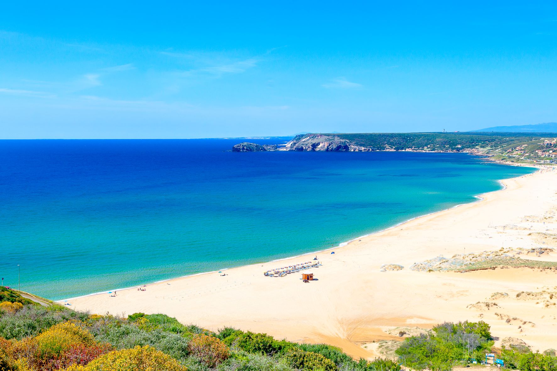
Golden sands of Pistis
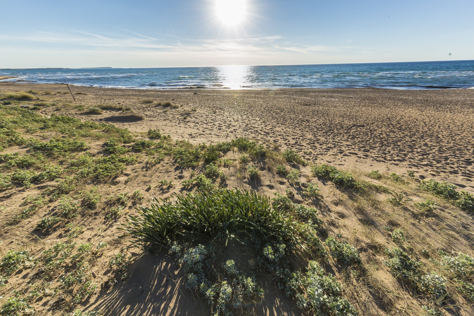
A vast stretch, a kilometre and a half long, of hills of fine, golden sand, modelled by an exceptional sculptor, the northwesterly mistral wind, which gives them unique and fascinating forms. The Golden Sands of Pistis, also known as Is Arenas 'e s'Ollastru (‘the sands of the water and of the wild olive’) border, in the south, with the splendid Torre dei Corsari and represent the northernmost beach of the Costa Verde, in the territory of Arbus. Patches of twisted junipers - one transformed by the poet Tziu Efisiu Sanna into a dwelling (the House of the Poet) - mastics, wild olive trees and other Mediterranean shrubs cover the 'Little Sahara', also coloured by hoary stock, sea daffodils and yellow hornpoppy in the springtime. Through the dunes, which are up to thirty metres high, upon your arrival, you can see the crystal clear waters that become emerald green in the sunlight.
The beach can be accessed by the persons with disabilities, has parking, dining and refreshments areas, services and bathing equipment rentals. Those who love the rocks will also be satisfied: at the end of the strip of sand, you will see basalt rocks standing out. S'Enna e S'Arca is located on the northern side, an impervious place, featuring basalt and sandstone shaped by the wind and the force of the sea, which conceals a series of hidden coves and is a destination frequented by fishing enthusiasts. The sandstone was also the object of ancient activities, to which a Punic-Roman quarry bears witness and can be seen from the entrance to the village of Pistis. Continuing on towards the beach, the rocks merge with the sand, creating natural pools, perfect for children.
The sea of the Costa Verde is all spectacular and wild. The dunes and the Saharan environment are a characteristic not only of Pistis and Torre dei Corsari, but also of Funtanazza, Portu Maga of Marina di Arbus and of the two undisputed ‘pearls’ of the coast, the ‘desert’ of Piscinas and the ‘talking’ beach of Scivu (so-called due to the sound the sand makes when you walk upon it).
Terralba
Between the inlets of the Laguna di Marceddì and the Stagno di San Giovanni, where Neapolis once reigned, a city founded by the Phoenicians and subsequently occupied by the Punic, then Roman and Byzantine populations, stands Terralba, a small town on the Campidano plane in the Oristano sub-region, 25 kilometres away. Known for its gavina watermelons and the communal winery (established in 1948), which produces monica and nuragus wines, Terralba is the second most populous town in the Province of Oristano, with over ten thousand inhabitants. The lagoon and pond, which together form a protected ecosystem stretching over 1,800 hectares, are home to over 5,000 birds. There are rare species such as the purple heron, western marsh harrier, pink flamingo and the western swamphen. The area contains many fish varieties, hence why fishing has always been practiced. From the hamlet of Marceddì, twelve kilometres from the city, come eels, mullets, wedge clams and mussels (nieddittas). The village, enriched by the Museo del Mare (Sea Museum), comes alive after Ferragosto on the occasion of the Sagra della Madonna di Bonaria, with processions on the ground and on the pond.
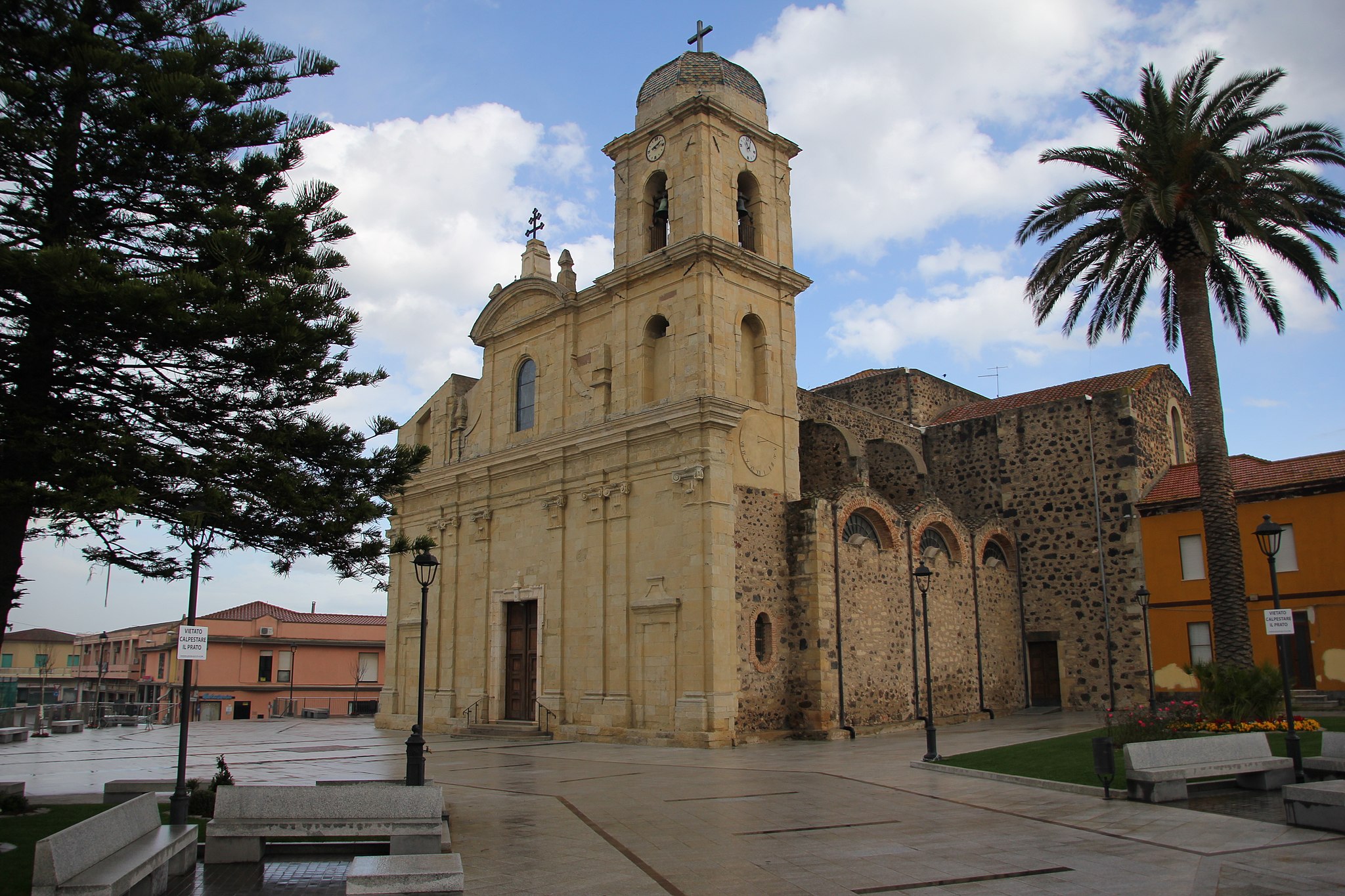
Legend has it that here once stood the village of Osea, founded by Hercules Libycus some 364 years before Rome (1000 BC). The Saracen raids forced the inhabitants to move to nearby Neapolis, surrounded by walls with angular towers and aqueducts, the ruins of which can be seen in the Stagno di San Giovanni. The city, grand and beautiful in the late Imperial era, was also important in the early Middle Ages. It fell around the year 1000 at the hands of the Barbarians. Perhaps in 1017, the survivors founded Terralba, which replaced it as the capital of the curatoria within the Giudicato of Arborea and as the bishop’s seat. The toponym appeared in 1048, coming from terra (land) and alba (clear). With the Neapolitans, Bishop Mariano I was also transferred. At that time in Terralba, there was the Chiesa di Santa Maria, the episcopal ‘dimension’ and the immediate prosperity providing the resources to build in 1144 the Romanesque church in honour of the patron saint, San Pietro. Built between 1820 and 1933 on this ancient (ruined) layout was the new majestic Cattedrale di San Pietro, in late-Baroque form, which contains Neapolis capitals and the former cathedral, baptismal font and wooden pulpit from the 17th century, along with a precious silver cross and statues of the saint and of the Madonna. The patron saint is celebrated at the end of June. Another sanctuary in the inhabited area is that of the Church of San Ciriaco, founded in 1741 and re-consecrated in 1958, which preserves a painting by Padre Lilliu, a sarcophagus of Mary as a child, a tabernacle from the previous building, and two statues of the saint, the smaller of which is used during the procession on 8th August. From the beginning of the 20th century are two Art Nouveau buildings, the elementary schools in Via Roma and the municipal house. From the feudal era, there are three coastal towers: Flumentorgiu, Marceddì and Torre Nuova. The ‘daughter’ of the 1919-28 reclamation is the fraction Tanca Marchese where, in mid-January, the Fuochi di Sant’Antonio Abate are lit, traditionally beginning of the carnival, characterised by allegorical parades with zeppole and malloreddus alla Campidanese. The first human settlements (in San Giovanni, San Ciriaco and Bau Angius) date back to the 7th millennium BC, thanks to the fertile soils, fish-filled basin and obsidian deposits of Monte Arci. Terralba also offers Nuraghic sites, including the Villages of Pomata and Coddu su Fennugu, along with a density of Punic testimonies (late-5th to late-3rd century BC) unlike any other Mediterranean context. In the locality of Pauli Putzu, ten Roman tombs were found together with grave goods, whilst a basin from a farm was discovered in the city. Some finds are kept in the Eliseo historical-ethnographic museum.
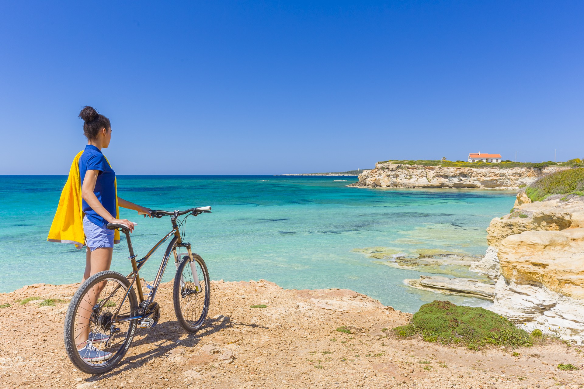
Torre dei Corsari
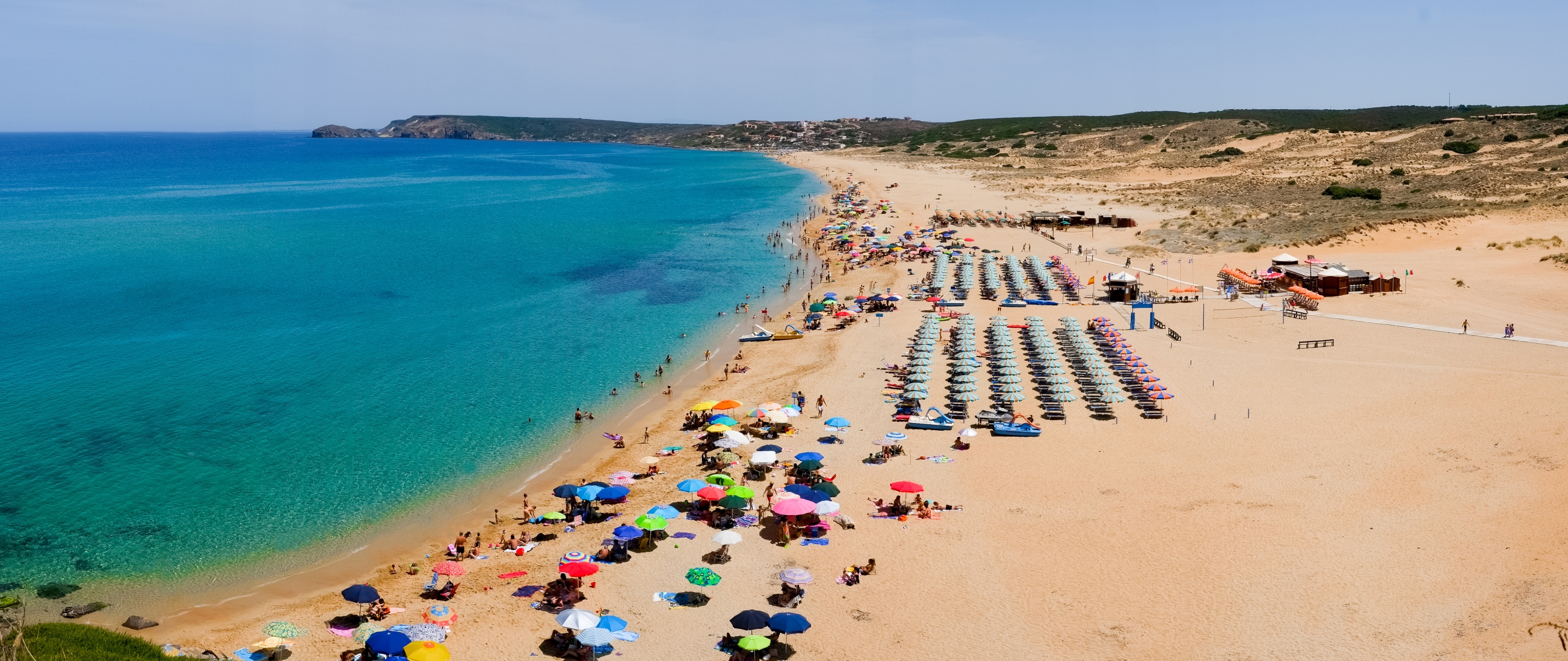
A desert bathed by emerald sea and swept by the wind that moulds it and turns it into an ideal destination for surfers. Torre dei Corsari is one of the pearls of the Green Coast, in the Arbus territory, and it is named after the Spanish tower called Flumentorgiu (17th century), a watchtower against attacks by Saracen pirates. From the promontory, you can admire, to the south, a bay with calcareous cliffs, while to the north you can see the immense Is Arenas ‘e s’Acqua e s’Ollastru beach, all the way to the delicious secluded coves and steep rocks, a paradise for fishing aficionados.
The beach is one and a half kilometre long: golden dunes of astonishing beauty, they look like hills, clumped and shifted by the endless action of the Mistral.
The colour of the sand, which is covered by sea lilies, wallflowers and sand poppies in spring, contrasts and highlights the landscape behind, made of hills covered by Mediterranean scrubs, with giant strawberry trees, junipers, brooms and mastics. From every angle and at any given time, Torre dei Corsari offers you unforgettable views, and, in the evening, marvellous sunsets. The beach is accessible to disabled people, has a parking area (for campers as well), and it is possible to rent umbrellas and beach chairs. There are also plenty hotels, cafés and restaurants.
The sea of the Green Coast is spectacular and wild, rarely calm, always demanding respect. The dunes are a feature shared by the entire coast: in the two kilometres of the Sabbie d’Oro of Pistis, where there is a juniper tree turned into the house of poet Tziu Efisiu Sanna (The Poet’s House), in Piscinas, a gem of the Green Coast where even Sardinian deer go for walks, and in the “talking” beach of Scivu, so called for the sound it makes when you walk on it. Other wonders include Funtanazza, Marina di Arbus, Portu Maga, where there is also a diving centre, and Capo Pecora, the southernmost limit of the Arbus coast, a popular destination among scuba divers and fishermen.

Fordongianus
It was once called Forum Traiani, when it was a main town in the island’s hinterland founded by the Romans during the Late Republic, when under Emperor Trajan it became a trading post between communities living inland and the Roman controlled populations of the gulf of Oristano. Today, Fordongianus is is home to less than a thousand people in the Barigadu region, famous for the thermal wellness spa constructed around hot mineral-water springs that have a constant temperature of 56°C all year round and provide a variety of health benefits. A detail the Romans were already aware of: the town sits on the left edge of the lush and fertile Tirso River Valley where warm Aquae Ypsitanae curative waters emerge from deep within the earth. The Roman baths here date to the first century CE and are now an archaeological attraction. Two establishments can be visited, one where a vaulted ceiling covered a rectangular pool with porticos along the sides and the other with a changing room. The floors were covered in mosaic tiles (you’ll see traces of them) and the ceiling was covered with a blue glass paste. Water flowed to it with great reliability via a network of canals, wells and cisterns. The importance of these baths is evident in the two statues of the god Bes, a divinity of health worship, and by a sacred area devoted to nymphs.
Fordongianus is also known for its red, green and grey trachyte quarries, the source of the stone used by the locals to build and decorate their houses. The XVII century casa aragonese is well preserved and was lived in until 1978. It is now a museum and a rare example of late-Gothic Sardinian architecture. Not far away is the XVI century church of San Pietro Aspostolo, made of red trachyte and rebuilt in modern times. A few kilometres out of town, near the thermal baths and the Roman amphitheatre, is the little church of San Lussorio, built by monks of the St. Victor order in the XII century over an early Christian crypt. The muristenes, once used as accommodations for pilgrims, are enchanting, especially when, during festivities in late August, they are enlivened by the faithful in prayer.
The area around Fordongianus is dotted with traces of prehistoric settlements: the stone domus de Janas di Domigheddas chambers and di Gularis necropoles carved into the rock in gorgeous natural settings, and the Paranu Antoni and Putzola nuraghes on the steep slopes of mounts Maiori and Ollastra, shaped into the most bizarre forms by centuries of the wind and rain. The most important Nuragic legacy near Fordongianus – at Villanova Truschedu – is the Santa Barbara nuraghe, with an original tower to which a second, smaller building connected by a walled-in passageway was later added. Just past San Lussorio is the area of Balargianus, made up of woods, vegetable gardens and vineyards. A climb to the top of monte Grighini, rich with quartz deposits, is a exciting outing. In its valley is the Casteddu Ecciu giara, with steep walls, home to the remains of a nuraghe and a castle, from which you can climb down to admire the monolith of su Crastu Ladu.
Capo Pecora
An unspoilt, picturesque place, far away from everything. Capo Pecora is one of the gems of the Costa Verde and is on its southernmost extremity, in the territory of Arbus. To the south, it is on the border of Portixeddu (Fluminimaggiore) and to the north it borders on another pearl of Arbus, Scivu. Its granite promontory stands out along a coastline dominated by limestone rock: the pink granite contrasts with the turquoise sea and the green Mediterranean scrub.
Sheer, windswept cliffs, overlooking the sea, outline it and frame the little beaches with pebbles smoothed by the relentless work of the sea. In the little coves, the rocks have taken on unusual guises: one of them is known as 'beach of the dinosaur eggs'. The biggest beach in Capo Pecora, surrounded by fragrant shrubs, has large-grained golden sand. The waters are particularly transparent and take on a bright sapphire blue colour - a true delight for the eyes.
The locality is quite sparsely frequented and is a silent, private oasis. It is known for its marine wildlife and the seabed is teeming with gilthead bream, flathead grey mullet, sea bream, octopus, amberjacks, sea bream and sea bass. Therefore, it is very popular with snorkelling enthusiasts: don't forget your mask and camera if you want to discover and immortalize the beauty around you and the wonders of the seabed.
With a long but not challenging trek through the cliffs and granite walls, from the promontory of Capo Pecora, inhabited since prehistoric times and perfect for palaeontology and fossil enthusiasts, you will reach the beach of Scivu, where you can visit its nature reserve. The trail, high up above the sea, unwinds along paths and mule tracks. Once you have reached the highest point of the plateau, at the watchtower, you can look out to the north at the spectacular view of the Costa Verde: the 'desert' of the wild and wonderful Piscinas and the other 'pearl' of Torre dei Corsari. Then you can go down the steep slopes to reach Scivu, where you can hear the sound of the fine-grained sand as you walk on it. The coast of Arbus is a long series of immense beaches with sand dunes that plunge into the waters tinged with blue and emerald green. It also includes Portu Maga, the Marina of Arbus and Funtanazza, captivating places and surfers' havens.
S'Arena Scoada
Slightly south of Capo Mannu, in the northernmost point of the Sinis peninsula marine area, in a setting of astonishing coastal beauty that alternates small coves and stretches of limestone rock, there is a long beach with an oceanic-tropical appearance. This is S'Arena Scoada, which extends from Punta S'Incodina, near the cliffs of Su Tingiosu, as far as Putzu Idu, from which it is separated by a small reef. The beach is part of the San Vero Milis territory, less than twenty kilometres away (while Oristano is 25 kilometres away), and it was originally known as S’Aena Scoada, meaning the donkey without a tail. The name was later transformed into 'sand without a tail', a type of very fine, golden sand alternated with tiny fragments of multi-coloured quartz, stones and smooth rocks. One of its distinguishing features is the limestone rocks mixed with clay, used for sand-baths. The water is very clear and it is a green-blue colour, while the sandy seabed slopes gently. From here, you can admire landscapes that open up towards the island of Mal di Ventre. The sandy shore is very popular with kitesurfing and windsurfing enthusiasts and it has ample parking and a bar.
Behind it, lies a small tourist centre, while to the north you can admire a fascinating arch dug out of the rock: S'Architteddu. Further on, there is the beach of Putzu Idu and other gems including Capo Mannu, an immense promontory that is almost an island, given that it is connected to the mainland by strips of land and by the Salina Manna pond. In order of appearance, first of all you will encounter Mandriola, followed by the coves of Sa Figu and Dei Tedeschi, Sa Mesa Longa, Su Pallosu and, after going beyond the promontory, there is Sa Rocca Tunda and then the little coves of Scal'e Sali. To the south, on the border of Riola Sardo, the rocky coast rises with respect to the water's edge, almost announcing the impressive sight of the cliff of Su Tingiosu. Erosion of the limestone has led to the creation of enchanting little coves.

Funtanazza
A suggestive stretch of coast where the golden colours of the sand, brown of the rocks and blue of the sea blend, in a scenario that for almost three decades, between 1956 and 1983, has been a 'summer colony' for many children. Funtanazza, set among the stupendous Torre dei Corsari and Marina di Arbus, was the first and pioneering resort in the uncontaminated and wild (then more than ever) Costa Verde, in the territory of Arbus. From June to September the children of the miners of Ingurtosu and Montevecchio, about twenty kilometres away, spent their holidays in the 'Francesco Sartori' seaside colony, built by the company that managed the mining sites - as wished by CEO Rolandi - "as the reward of so many labours, so many sacrifices, so much darkness accumulated in the tunnels". You can reach it by taking the state road 126 through a world crystallized in time, made of abandoned mines and ghost villages. The nearest services are in Marina di Arbus, Torre dei Corsari and in the tourist village of Portu Maga.
The inlet of Funtanazza welcomes, partly sheltering it from the mistral, a stretch - about one kilometre - of medium-grained golden sand, bathed by the limpid sea with its colours shifting between green and blue, with a sandy bottom dotted with a few rocks, which gets deep very quickly. The beach is bordered by cliffs covered with thick Mediterranean vegetation: on one side large basalt rocks hide small caves, while on the other the cliff slopes gently. To the south, down to sa Cabada bianca point you will be able to pick your way between volcanic rocks containing an infinity of fossils easily visible on the white cliff, dating back to the Miocene. The complex, impressive in size, overlooks the beach. A verdant pine forest of nearly eight hectares overlooks the coast, along with the imposing complex of the former colony, which occupies more than two thousand square metres and could accommodate about two hundred children and sixty adults. Consisting of three distinct areas, including accommodation facilities and two swimming pools, it was autonomous thanks to the aqueduct, electric cabin, radio link and telephone systems, as well as access roads. When built (1956) it was considered a futuristic structure, the most modern in Europe. Today it is a huge and spooky building awaiting redevelopment.
South of Funtanazza you will discover the two most splendid pearls of the Costa Verde: Piscinas, a sandy desert lapped by the emerald sea, and the 'talking' beach of Scivu. Other spectacular dunes on the north end of the coast are the Sabbie d'Oro of Pistis.
Is Arenas
The name means ‘the sands’, or more specifically 'sand dunes' and they are among the most extensive in Italy. It is a small desert, where reforestation began in the 1950s, with pines and acacias, because the dunes risked expanding and turning the internal area into a desert. Today it has become a vast green area, where there is a pine forest and a golf course. Is Arenas (or Sas Renas) stretches for almost six kilometres: it is one of the longest beaches in the Oristano area, delimited to the north by the tip of Torre del Pozzo and to the south by a canal that links the sea and the pond of Is Benas. The central (and largest) part of the sandy shore is in the territory of Narbolia, while the southern part is in San Vero Milis and the northern part is in Cuglieri.
The beach has reddish-yellow sand with hints of gold, mixed with pebbles and shells on the water's edge. In some areas, you can admire pure white sand, like grains of rice, washed by the transparent water. Behind it, the landscape is dominated by the woods of Montiferru, while towards the sea you will see Capu Mannu, the northern tip of the Sinis peninsula and the protected area in which it is located.
It is often windswept by the strong northwesterly mistral wind and is, therefore, frequented all year long by windsurfing enthusiasts. Entering the water is not recommended in such conditions, while simply observing the sea will give you exciting sensations. The beach can be accessed by the disabled, it has ample parking and it is suitable for camper vans. There are also campsites, restaurants and bars.
The central stretch of the western coast, in the province of Oristano, is made up of beaches with fine sand or grains of quartz alternating with cliffs. Not to be missed, a little to the north of Is Arenas, is S'Archittu of Santa Caterina di Pittinurri (Cuglieri), one of the symbols of Sardinia, and also the beautiful beach of Putzu Idu. To the south, there is the Sinis peninsula, which boasts three absolutely beautiful pearls in the territory of Cabras: Mari Ermi, Maimoni and Is Arutas. Descending along the gulf, you will find the marina of Torregrande, the city beach of Oristano, and San Giovanni di Sinis, near the archaeological site of Tharros.
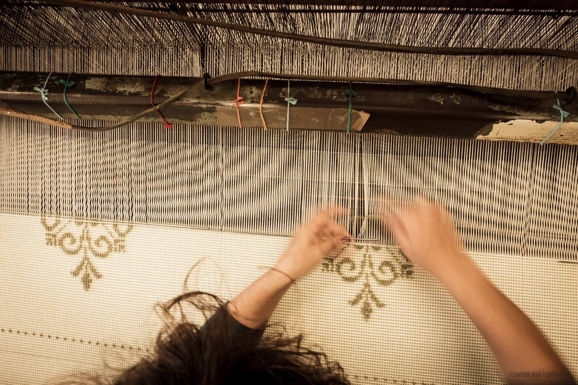
Samugheo
The town has an incredibly valuable textiles craft heritage handed down over the centuries. Samugheo, a town of around 3000 inhabitants in the Mandrolisai area, in the province of Oristano, is known for its production of rugs, tapestries and traditional clothing. It is part of the Borghi Autentici d’Italia circuit and is set in the lush and wild scenery of the Brabaxianna (‘gateway to Barbagia’), among solitary hills, crevasses, rocky cliffs, springs, oak woods and Mediterranean brush. There are numerous caves: ‘dell’Aquila’, sa Conca ‘e su Cuaddu, and the Buco della Chiave with its hour-glass shape.
The town centre, originally divided into four neighbourhoods each with its own "microcosm", is characterised by two-floor houses with balconies, doorways and frames in red trachyte. The houses are decorated with murales representing the town's emblem: rugs. On the outskirts is Murats (regional textile art museum), where you can admire splendid examples from all over Sardinia. The ethnographic section hosts wooden looms and other equipment. Some of the rarest items are the affaciadas, small tapestries put on show during Corpus Domini, and five 18th century tapinu de mortus (only eight of these exist in the whole of the island). The tradition is also renewed each year by the Tessingiu, the most important textiles trade fair in the island. The town is also famous for pecorino cheese, wine and bread-making, which has its own festival in October.
The territory has been settled since Neolithic times, as shown by the domus de Janas at Spelunca Orre. The most important Bronze Age remains are the Giants' tomb of Paule Luturu and the Perda Orrubia nuraghes. Clear traces remain of the Byzantine period, in the form of religious customs and Medusa Castle, named for the legend of Queen Medusa. The fortress clings to a cliff face, entirely dug out of the marble. It was first built in the 4th-5th centuries and construction continued in phases up to the 12th century. The remains are considerably overgrown, but you can still spot areas of walls, a cistern and the remains of two towers. Religious buildings include the 16th century Church of San Basilio, patron saint of the town and who legend claims saved it from the plague, the Church of San Sebastiano, possibly from the 13th century and extended in the 15th century, with a Latin cross layout and late Gothic decorations, and the sanctuary of Santa Maria di Abbasassa, built 450 metres above sea level on the site of an ancient pagan temple. The oldest church is perhaps San Michele, now in ruins. The town's name was once thought to come from this church, known as San Migueu in Catalan and San Miguel in Castilian Spanish; however, a will by Ugone III (1336) referring to Sumugleo and another by the majore de Villa Summungleo (1388) have shown this to be false. The most famous festival is A Maimone, a Samugheo carnival with a display of masks from all over Barbagia. The bonfires of Sant’Antonio and San Sebastiano in mid-January lead into the carnival period.
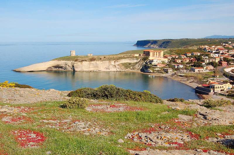
Santa Caterina di Pittinuri
Initially, there were a few houses, used as a ‘base’ by shepherds during transhumance, located around a small church dedicated to St. Catherine. From the middle of the 20th century, progressive growth in construction turned the little village by the sea, a district of Cuglieri, into today’s renowned seaside resort. Santa Caterina di Pittinuri is located on spectacular cliffs, surrounded by the green elevations of Montiferru, with the sixteenth-century tower of Pittinuri overlooking it, which gave it its name and stands on the promontory to the north of the village. As well as the village, an inlet of limestone rocks contains and shelters a beach of golden, reddish and black pebbles. The sea is clear and shallow, making it suitable for children, while on days when the northwesterly wind is blowing, the cove is a paradise for wind and kite surfers. The view a little further north, at su Riu ‘e sa Ide, is decidedly wilder, where strips of limestone rock gently slope towards the emerald green sea.
Inside the village, there is a little church of medieval origin, where the feast of St. Catherine is celebrated in mid-May: the sanctuary becomes the destination of a pilgrimage that starts at the basilica of Cuglieri. Three kilometres away, to the south-east, the ruins of Cornus will tell you a story that dates back to the Punic era, about prosperous trade, the struggle for independence against Rome and a new existence as episcopal centre of the island in the early Christian era. A little closer, two kilometres from Santa Caterina, you will find another of Cuglieri’s marine hamlets, that of s'Archittu, featuring a spectacular arch sculpted by nature on the limestone rock and its ochre-coloured beach. In the southern part of the village, you will find the beach of Stella, also known as the ‘beach of priests’ because it was once the site of a summer seminary. The light sandy beach is dotted with flat rocks and enclosed by the rocks of the promontory of Balena (the Whale), where the Torre del Pozzo stands, which is also the name of Cuglieri's third coastal hamlet. Here, a flight of stone steps leads to the little beach of sa Capanna, where you will be struck by the beautiful contrasting colours of the light sand, the turquoise reflections of the sea and the white tuffaceous rocks. This is one of the favourite locations of diving, underwater fishing and snorkelling enthusiasts.