

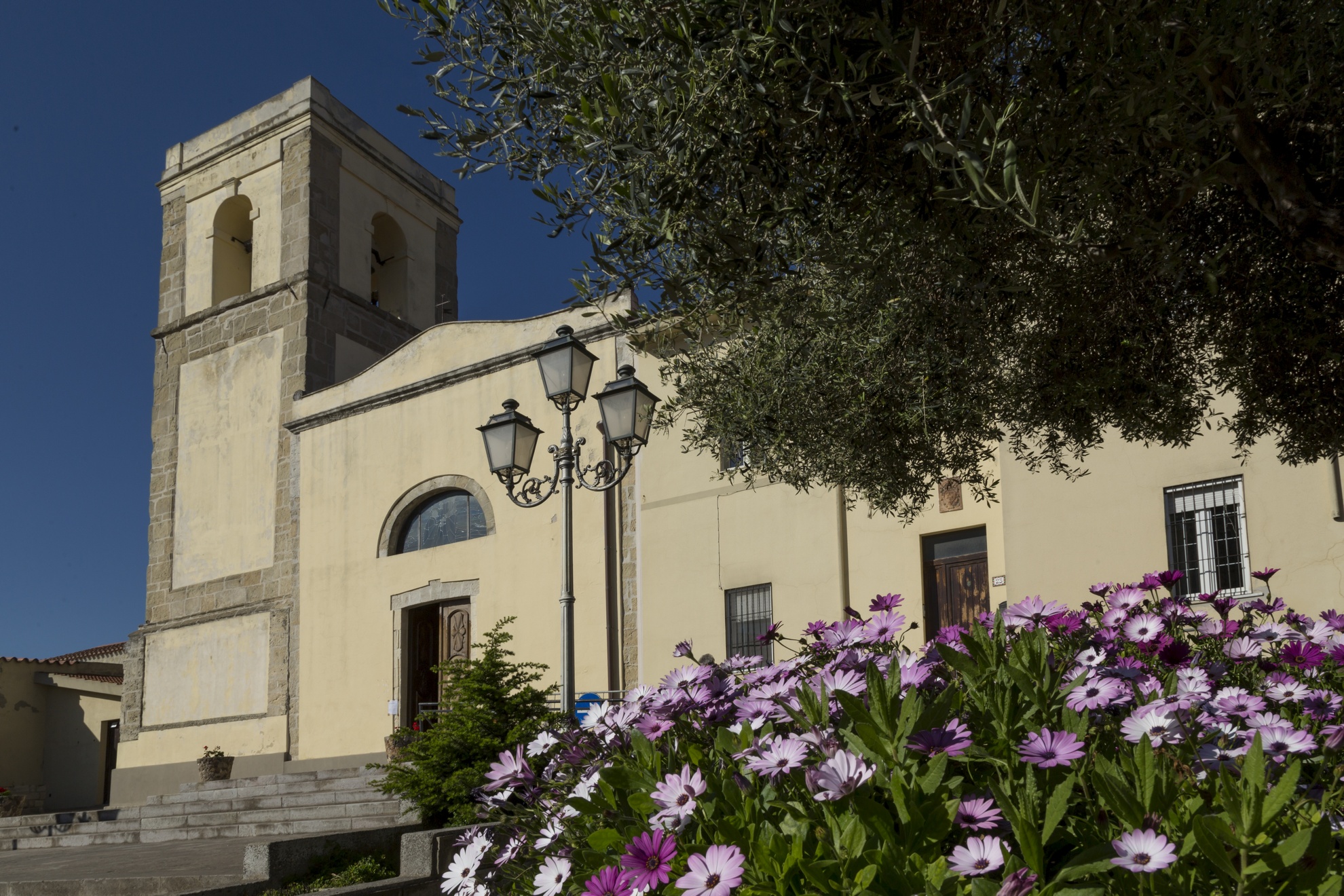
Villamassargia
It lies in the valley of the Cixerri river, surrounded by the hills of the Iglesiente region. Villamassargia is a village with fewer than four thousand inhabitants, in which ancient textile traditions are still intact: numerous artisan workshops produce rugs, tapestries and household articles. The creation of objects made of wrought iron and wood is also remarkable. The agri-food products are of excellent quality: from cheeses to olives and olive oil, bread and pastries. In the old town centre, there are typical agricultural-pastoral houses next to two religious buildings. One is the parish church of Madonna della Neve, originally built during the first decade of the 12th century by the Benedictines and today it has a Gothic-Catalan style, resulting from the various phases of its reconstruction between the 14th and 16th centuries. The second one is the church of Nostra Signora del Pilar, that offers an uncommon factor in Sardinian medieval art: from an epigraph on the facade, not only can the date of its construction be obtained (1318), but also the name of the builder (Arzocco de Garnas). It was first named after San Ranieri, celebrated at the beginning of September. The façade, which is Romanesque style, has maintained its original appearance, in sedimentary rock, with a depiction of Eve with the snake. There is a beautiful rose window over the entrance portal.
Villamassargia reached its maximum splendour during the Middle Ages, when it became the capital of a curatory in the Guidicato of Calari. The Castle of Gioiosa Guardia, dates back to this period and its ruins are located on a hill four kilometres from the village. The name indicates the role of control it held over the valley of the Cixerri river. It was built between the 12th and 13th centuries and is made entirely of andesite, at the behest of the counts Della Gherardesca. It was later possessed by the republic of Pisa and, in the end, it was absorbed by the Aragonese. At the foot of the fortress, there is an open air museum, S'Ortu Mannu, where there are more than 700 majestic centuries-old olive trees, transplanted there between 1300 and 1600, with robust and knotted twisted trunks. One of them, Sa Reina, has a trunk of over 16 metres in diameter, a natural monument. At the end of October, the feast of the olives takes place in the park.
Villamassargia participated in the mining epic of Sulcis. The greatest legacy of industrial archaeology is the mine of Orbai, nestled in a forest and already used in the Roman era and abandoned in the nineteen sixties. Lead and zinc were extracted there. The territory is also dotted with archaeological sites, from the Ancient Neolithic period, as is confirmed by materials found inside the grotto of Corongiu Acca. The numerous Nuraghi date back to a later period (2nd millennium BC) among which Santu Pauli and Monte Exi, Tombs of Giants of Mount Ollastu and several sacred wells. An aqueduct and foundries date back to the Roman period.

Licheri Watermill
Fluminimaggiore was established in 1704, following an act of vassalage. At that time, its inhabitants chose to make the most of their main natural resource, the Rio Mannu river, by building mills along its course: in the second half of the 19th century there were 21 of them! One of them, built as early as the mid-eighteenth century, now has a new life. It is the Licheri mill, which currently accommodates the ethnographic museum set up by the Municipality of Flumini, with the collaboration of the population. Its millstones are still perfectly functional, despite the fact that almost three centuries have passed since its creation: the exhibition set up inside narrates its 270-year history, where you will come into contact with ancient trades and customs linked to the agro-pastoral cycle of life.
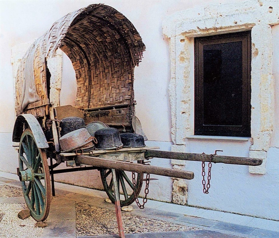
You can get to the mill by crossing a wooden bridge: the external structure is divided into three parts with ladiri masonry (mud and straw bricks) and reed roofing. Ploughs, harrows and an olive press wheel are on display in the courtyard. Under the main building, the water wheels moved (and are still operational) the two millstones, located inside two niches. The indoor museum exhibition consists of ten rooms: you can admire tools for wine-making and oil production, with a press made of chestnut wood; a room dedicated to blacksmiths and farriers; a bread oven and tools for cheese-making; a weaving room and several rooms reconstructed as domestic environments, kitchens and bedrooms. Rooms 3 and 4 ‘tell’ the story of milling, starting from Nuragic finds and ending with an electric mill from the 1930s. You will be impressed by the large silos made from woven reeds, designed to contain cereals. The millstone is formed by two overlapping basaltic stones: the lower one, su koru, is stationary, while the upper one, the tunica, rotates as it is connected to the water wheel set in motion by the current of the river. Hanging on the walls, there are tools used by housewives to sift flour, a sieve and a wooden frame. The last room contains an ox cart and a carriage from the late 19th century. There is no lack of interaction with children: they will be able to experiment with various tools and discover toys from the past.
On the subject of activities from the past, a ruin from the historical mining period, the ‘ghost’ village of Malacalzetta, appears in the lush woods. Fluminimaggiore is not just industrial archaeology, but also Punic and Roman, thanks to the Temple of Antas, one of the monuments that best represents Antiquity on the Island, standing in a lush green valley. Then there is a masterpiece of nature: five kilometres from the town lie the enchanting su Mannau caves, with rooms dotted with stalactites and stalagmites of various shapes and embellished by little lakes. Lastly, there’s the sea: the beach of Portixeddu with its seaside village is the other great attraction of Flumini.

Turcus e Morus Multimedia Museum
Legendary figures, legends and tales of battle, assaults and brave defences: the most violent of times in Sardinia’s history are marked by vicious pirate invasions and are on display in a unique exhibit. The Turcus e Morus multimedia museum in Gonnostramatza is housed in the halls of the former monte granatico. The idea of bringing to life the dramatic era of invasions carried out by the fearsome Saracens comes from an epigraph preserved in the church of San Paolo, two kilometers from the town. Here you can see proof of the destruction of the nearby town of Uras de manu de turcus e morus e fudi capitanu del morus barbarossa (by hand of the Turks and Moors led by the Moorish pirate Barbarossa) on 5 April, 1515.
This historic invasion is the starting point for the telling of the events that spanned ten centuries (the 8th to the 18th) on the coasts and inlands of Sardinia. The multimedia tools have the protagonists themselves telling the stories they played a part in, with interactive touch screen video-portraits, life-size holograms and the reconstruction of coastal towers - built by the Spaniards to combat the pirates – as well as naval bridges on which the figures of the pirate stories move about. You can also see dioramas, models of boats and period weapons.
One of the halls houses the digital reproduction of the retablo dell'Annunciazione, painted in 1501 by Lorenzo Cavaro, the man who started the Stampace school of Cagliari. The original hangs in the parish church of San Michele Arcangelo. Among the animated figures you will see and hear are Barbarossian pirates, Christian slaves and Sardinian tower fighters, as well as Barbarossa himself and the others that took part in the historical events that plagued the Mediterranean between the 15th and 17th centuries. You will explore the village of Sèrzela, now vanished but described via archaeological remains and descriptive videos, home to the last remaining vestige, the little church of San Paolo. The village was a refuge for those inhabitants of Uras who survived the onslaught. The museum periodically organises educational events, and is accessible to the handicapped and the visually impaired.
Aside from the parochial church, built between the 17th and 18th centuries over a Gothic-Aragonian structure, and the old parochial church of Sèrzela dedicated to San Paolo, Gonnostramatza is also home to the little 16th century church of Sant’Antonio Abate, set along the old main road that connected with the nearby villages. The town is a member of the sa Corona Arrubia consortium, founded to raise awareness of the local archaeological remains, the most important of which is the Eneolithic tomb known as Bingia e Monti, where the oldest gold coin ever found in Sardinia was unearthed.
Ortacesus
It stretches in the lowlands north of Flumini Mannu which, along with three artificial streams flowing passed the town, has always maintained the fertility of its lands. Ortacesus is a small town of less than one thousand inhabitants in the centre of Trexenta. In ancient times, it was one of Rome’s granaries and remains a centre of cereal production (wheat and maize) to this day. The summer Wheat Festival, which focuses on traditions related to the harvest, and the Museum of Wheat year-round are proof of this. The museum is housed in the very old Casa Serra, the town’s traditional mansion. An extensive exhibit of artefacts and tools – including a rare wooden spring – illustrate traditions that have been passed down through the generations and ancient male (seeding, working the land and harvesting) and female (weaving, and bread baking) jobs. The museum also includes La Via del Pane (The Road of Bread), and unfired brick and culinary workshops followed by a tasting of typical dishes.
The town is also known for the cultivation of sugar beets, grapes and vegetables, as well as for traditional crafts, including embroidery of traditional clothes, weaving and production of musical instruments, such as the launeddas. A unique local peculiarity is a large ostrich farm, founded in 1997. The town was first mentioned in Medieval documents as Ozrokesus. Around the year 1000, it became Orzochesos, and then, with time, Ortechesus. The urban layout reflects the Trexenta tradition: straight streets and repeatedly intertwined alleys. In the city centre, the eye is drawn to the Parish of San Pietro, a Catalan Gothic church built between the end of the 16th and the beginning of the 17th centuries. It houses a notable wooded altar and statues of Madonna del Rosario and of various saints, dating to the 17th and 18th centuries. The Church of San Bartolomeo, built over an antient Roman pagan temple located about one kilometre from the town, is older yet (12th century). It is said that it was the church of the original Ortacesus village, before it was moved to its current location. Today, the residential area stands in an area with closely spaced settlements, along the transect between Senobi and Gausila, along which there are numerous mineral water springs, including Mitza s’Orrù, Mitza su Fenu and Bangius Fountain, already in use during the Roman period to supply baths. Roman ruins can also be seen by another spring, Sa Mitza Siddi. But, the earliest evidence of a human presence is prehistoric in age: several Bronze age nuraghe, including the famous S’Omu de S’Orcu at the border with Guasila.
Maraté - Museum of Copper and Textile Art
It is the only copper museum in Sardinia, but above all, it is a journey back in time to a world made up of workshops, ancient know-how, voices and sounds from streets, piazzas and artisanal workshops that made deeply symbolic luminous objects in cramped, dark, busy coppersmitheries, but also gorgeous tapestries made by the local weavers. These are the main artisanal traditions typical of Isili, a “bordertown” between southern Sardinia and Barbagie. This heritage is displayed in the rooms of Maraté, a museum dedicated to the art of coppersmithery and textiles housed in the 18th century Scopoli convent. The exhibit is made up of three sections, one for copper and two for the art of textiles.
The first illustrates how copper was traditionally worked and sold on the streets. You’ll see a typical cart loaded with new items and copper objects gathered to be smelted. In the reconstruction of a coppersmithery you’ll even see some of the original tools they used. The copper items are also displayed in keeping with how they were used at home, by peasants and shepherds, their social and aesthetic value, and as parts of a wedding trousseau, for example. The artistic section dedicated to textiles contains thirty tapestries, a synthesis of tradition, research and innovation. Informational panels document how the work is done, from the processing of the wool to its dying, including the use of copper, and gold and silver thread for lovely chromatic effects. A third section has been added to the museum and is dedicated to the ethnographic aspects of the weaving. The museum experience is further enhanced by a soundtrack of music, voices and audio effects that characterise each room, making it feel as though you are walking through the village and even hearing the “secret” jargon of the coppersmiths, s’arromaniscu or arbaresca.
Isili sits within a natural park with enchanting landscapes and archaeological treasures. You can go for a hike or cycle along the shore of San Sebastiano Lake, even do some fishing or canoeing. On an island in the middle of the lake is the little church of San Sebastiano. Just a kilometre outside of town is an example of one of Sardinia’s most elegant Nuragic architecture, is Paras. This nuraghe has a central tower and three secondary towers connected by a wall. The inner room has a false dome ceiling that reaches almost 12 metres, the tallest in all of Nuragic Sardinia.

Piscinas
Stretching along a plain surrounded by undulating hills, it shares its name with the torrent that crosses the territory and flows into the lake of Monte Pranu. Piscinas is a rural village with less than 900 inhabitants, located at the centre of the lower Sulcis mining basin, historically linked (and at one time, also administratively) to Giba, an autonomous municipality since 1988. Its main resources are the cultivation of artichokes, citrus groves, vineyards and sheep-breeding, as well as a bentonite factory. Its fame is also connected to the artisan production of Sardinian wickerwork.
The first human remnants in the territory date back to the ancient Neolithic period (VI millennium BC), found in the cave of Su Benazu, upstream of Miana and in the Tatinu rock. The Domus de Janas of Tuttui and Monte Medau date back to the end of the Neolithic period. Remains from the Bronze Age, which can be admired in the place of worship of Monte Sa Turri, in the fortifications of Monte Murrecci and in the Nuraghe Corongiu Longus, De Frois, Is Ulmus, Matas, Santa Lucia, Santus and S'Acqua Callenti, where there are thermal springs, today called Sa Cracchera, which were utilised in the 19th century and contributed to the development and renown of the town. Not to be missed are the Phoenician-Punic and Roman ruins, in particular the fortifications of Pani Loriga, built to defend the territory from Saracen raids, which gradually weakened the territory through to the early Middle Ages, when it was completely depopulated. After the year 1000, thanks to the work of a community of monks, a village was established on the site of the current one. During the domination of the Judicatus of Caralis and maritime republics, it was initially called Piscinae, then Pixinas. From 1337, passing to the Aragonese, it became the Villa (or ‘Salto’) di Piscinas. In 1538, it was subjected to enfeoffment by the Spanish patrician family of the Salazar, who held it for a long time and built Villa Salazar on what is today the centre of the town. The ancient noble residence was rebuilt in the late-19th century and renamed Villa Bice, designed by the engineer Giorgio Asproni Junior, nephew of the famous Sardinian deputy and scholar. Today, it can be visited amidst the greenery of a large local park. Alongside is the Piazza San Giorgio, with a beautiful mosaic depicting the saint battling a dragon, and the Chiesa di Nostra Signora della Neve.

Senorbì
Senorbì is the geographical and economic hub of Trexenta, a historically-rich territory, nicknamed the ‘granary of Rome’ in antiquity. A town of 5,000 inhabitants currently experiencing demographic growth - a rarity amongst the non-coastal Sardinian Municipalities - Senorbì thrives on the cultivation of sugar beets, wheat, olive groves and vineyards, being a commercial point of reference for the area. Its fertile territory encompasses hills and flat stretches, furrowed by tracks to be travelled by mountain bike or on horseback. The colours change with the agricultural cycle: the brown of the earth in autumn, the green of the wheat growing in spring, the blond expanses of crops during the summer. There is a great passion for horses that sees riders from all over southern Sardinia come for the feast of Santa Vitalia so as to compete at a trot during Is Cuaddus de Santa Vida, reaching the 19th-century Villa Aresu in the hamlet of Sisini.
Other manor houses embellish the historic centre, formed by a network of narrow streets overlooked by houses with a rural matrix. The parish church of Santa Barbara, the 17th-century church of San Sebastiano and the Chiesa di Santa Mariedda, built at the end of the 13th century as a sanctuary of Segolay, the main medieval Villa of Trexenta, complete the picture. On the façade are the neat rows of sandstone blocks of Roman ‘manufactory’. The festival in honour of the patron saint takes place at the beginning of August, preceded by a folklore festival at the end of July. Another 19th-century house has been set up as an archaeological museum: Sa Domu Nosta. Pre-Nuragic artefacts come from inhabited areas and necropolises. From the 3rd millennium BC, there is the famous Mediterranean mother goddess, the statuette found in Turriga (Selegas), as a testimony of the exchanges with the Aegean. The museum itinerary follows the Nuragic age. In the Senorbì countryside, the imposing Su Nuraxi in Sisini remain, with an unusual planimetry, similar to a holy well, part of the tower of the Nuraghe di Simieri and the remains of the tower of Monte Uda. The finding of a fundamental Nuragic structure is the Miles Cornutus, a bronze figure depicting a warrior with very high horns on the helmet, found near the town in 1841 and now held in the National Archaeological Museum of Cagliari. The arrival of the Carthaginians changed the area profoundly: acropolis and houses (perhaps also forging workshops) constitute the hill settlement of the Santu Teru (6th-3rd century BC), connected to the Monte Luna necropolis, comprised of 120 tombs, mostly of the well variety, as well some in pits, a selection of which are decorated in red ochre. The rich funerary objects confirm that it was a thriving town. Items include talc amulets, silica paste, metal, bone and glass, amphorae, jugs, perfume burners, cups, lamps, plates, coins, jewels and jewellery in gold, silver, bronze and iron (rings, bracelets, tiaras, earrings and necklaces generally). Artefacts of Egyptian inspiration and of Greek and Central-Italic importance have been determined. Together with the remains of a villa in Bangiu, Monte Luna also represented the most important hub of Roman times. It is hypothesised that the surviving inhabitants founded Senorbì.
Villaperuccio
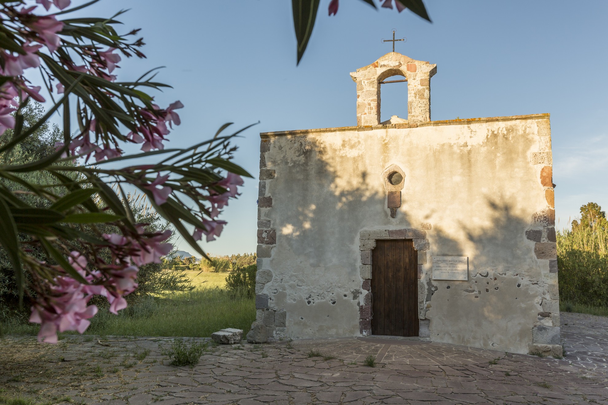
Stretching on a plain in the heart of Sulcis and known as Sa Baronia, Villaperuccio is a town with just over 1,000 inhabitants that became an independent municipality (from Santadi) in 1979. The current urban centre was born perhaps upon the arrival of monastic communities between the 11th and 12th centuries. Symbolising the comparison with the first settlements is the medau or furriadroxiu (small rural agglomerate) of Is Meddas, a hamlet of the village, which conserves its original structure - a central courtyard overlooked by low-rising farmhouses and a little landowner's edifice. In the village stands the parish church of Madonna del Rosario, built in 1913 thanks to the donation of a wealthy landowner. The patron saint is celebrated at the end of August. In the town, at Is Grazias, stands the Sanctuary Madonna delle Grazie (16th century), alongside which the remains of a Roman necropolis have been found. Festivities are held in the town church in July, whilst the Sagra dell’Arancio (orange festival) takes place in March.
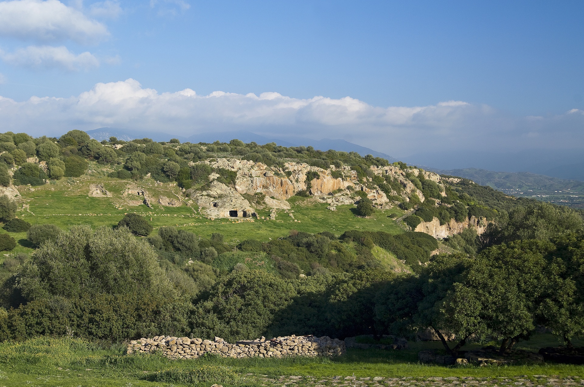
The territory of Villaperuccio consists of an alluvial plain to the south and a semicircle of hills of volcanic origin that enclose the plain to the north. From the hills set out streams that flow into the Rio Mannu, which in turn flows into the Monte Pranu lake. This land has been inhabited since the recent Neolithic period, as is evidenced by many pre-Nuragic remnants. A little more than a kilometre from the lake is the necropolis of Domus de Janas di Marchianna. At the peak of s'Arriorxu are the remains of a cultural village of Ozieri (3rd millennium BC), which was headed by the largest Domus de Janas burial ground in southern Sardinia, the necropolis of Montessu, which opens on the southern flanks of the Sa Pranedda hill, a few kilometres from the village in a beautiful natural amphitheatre. It has 40 sepulchres of various sizes and layouts, mostly multi-chambered (with anti-chamber, main chamber and secondary chambers). The rooms are preceded by vestibules and have niches and cupels, with entrances once closed by doors. The two hypogea at the ends of the rocky amphitheatre are distinguished by their monumentality, flanked by two Domus of great significance in symbolic religious terms (tomb-sanctuary): the 'tomb of spirals', decorated with wolf’s teeth in red ochre and with numerous spirals symbolising the eyes or breasts of the Mother Goddess, candelabrum motifs and false door (a passageway to the afterlife); and the 'tomb of horns', where horns of various shapes, alluding to the god Taurus, are carved. The site was used for a millennium until the late Aeneolithic and Ancient Bronze Age (2400-1600 BC). Not far from the necropolis are two imposing perdas fittas: in the locality of su Terrazzu, the menhir of Luxia Arrabiosa - the protagonist of many a popular legend - and another menhir six metres high atop Monte Narcao. Other menhirs, in trachyte or granite, are Is Perdas croccadas, Is Pireddas, Is Melonis, Bacc’e Fraus, Is Faddas and Is Cotzas. From the Bronze Age come the ruins of 40 small and medium Nuragic structures and a Nuragic hut in the village, close to the town hall.
Giba
Based on tradition, its founding dates back to the Vandal king Genseric in 500 AD. Giba is located on a plain surrounded by low hills, a few minutes from the sea. The main residential area and district of Villarios, situated along the Karalis-Sulki Roman road (Sant'Antioco), have over two thousand inhabitants. The fertile territory facilitates the production of excellent oil and Carignano wine, artichokes, to which a festival is dedicated in mid-March (at the same time as the festivity in honour of St Joseph), and cheeses. The bread is baked in traditional ovens: at the beginning of August, in the bread festival, as well as the typical local dishes, you can taste several variations: civraxiu, coccoi, pan 'e saba, bread with olives, Ricotta cheese and Lardo. There are delicious pastries (gueffus pabassinas, pardulas and pistoccus) and works of art, like the textile goods: rugs and tapestries. The local artisans also offer you knives, baskets and Is pippias de cane, little dolls made of reeds.
Around the village, the gentle hills, covered in Mediterranean scrub and centuries-old olive trees, look out onto the Gulf of Palmas. On the beach of Porto Botte, now frequented by kite surfers, the infant Alfonso disembarked 1323: it was the beginning of Spanish domination that lasted four centuries. Next to it, there is a lagoon, the habitat of black-winged stilts, western marsh harriers, greater flamingos and the western swamphen, an attraction for birdwatching enthusiasts. Nearby, there is the lake of Montepranu, ideal for recreational fishing enthusiasts. Approximately 15 kilometres to the south, you will find the beaches of Sant'Anna Arresi and Teulada.
Giba has been inhabited since the Neolithic period, as is confirmed by the Domus de Janas of Is Gannaus, dating back to 3500 BC. Dating back to the Bronze Age, there are various types of Nuraghi, among which Nuraghe Villarios, which was built to control the coast, and above all the complex (in excellent condition) of Nuraghe Meurra (12th century BC), on the border of San Giovanni Suergiu and Tratalias, which also includes a village, a sacred well and a Tomb of Giants. There is no lack of Phoenician-Punic evidence, while traces of Roman times are even clearer: the ruins of two villas, the remains of a road, a bridge and thermal baths. It is assumed that the village was founded during the Vandal invasions: North Africans from Mauritania were deported and left their facial features as a legacy in the Sulcis area. At the end of the first millennium, the Benedictine monks of Montecassino and the Monks of Saint Victor of Marseilles gave impetus to the community and the territory, building monasteries here (one is still intact in the outskirts) and Romanesque churches, among which that of Santa Marta is still standing in Villarios (perhaps built in 1066), on a high ground: from above, you can admire the shoreline and the Sinis archipelago. St. Marta is celebrated at the end of July, while the patron saint, Peter, is celebrated for three days at the end of June. An evocative procession takes place with a parade of worshipers in traditional dress, horsemen and launeddas players.
Cala Lunga - Isola di San Pietro
The bay of Cala Lunga, in the locality of La Punta on the Island of San Pietro, is a rock cliff which plunges down into the sea. Its waters are of a changing blue due to the plays of light created by the sun reflecting off the sea bed. The bay is positioned between La Punta and Le Tacche Bianche, this latter an imposing vertical cliff. Out to sea, some few hundred metres from the shore, fishing nets can be seen which are used to catch the precious tuna fish which is exported from the Island of Carloforte as far as Japan, one of this activity’s best clients. The Island of San Pietro also includes the two smaller islands of Piana and Topi, and is separated from the Island of Sant’Antioco by the Colonne channel. Its coastline is jagged with caves and vertical cliffs but more sandy on the western side. The only town is Carloforte, founded in 1738 by a group of Ligurian fishermen hailing from Tabarka in Tunisia. The town can be reached from Calasetta and Portovesme in about 30 minutes by ferry.