

Campionna
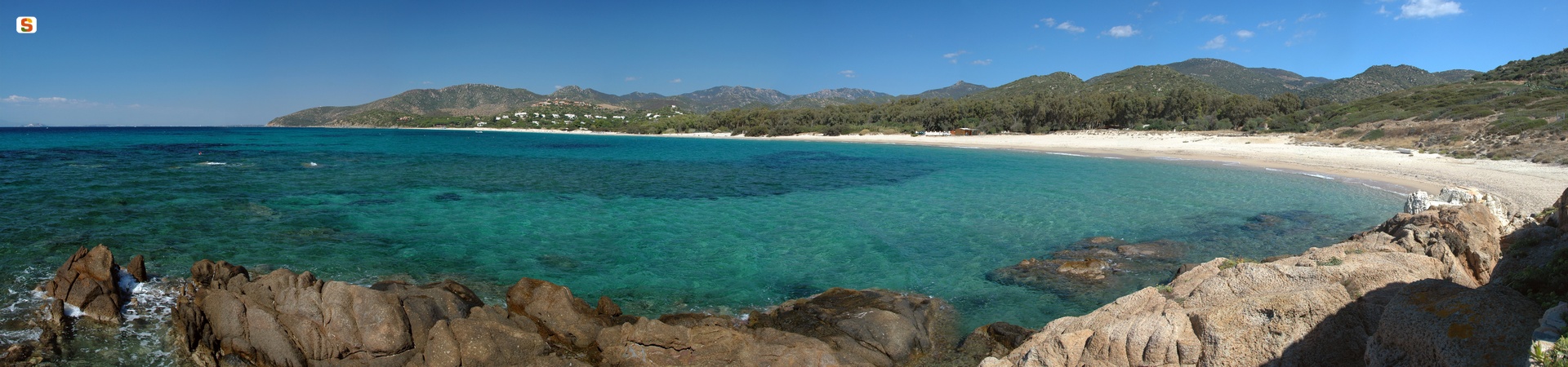
Among the Island’s scenic roads, provincial road SP 71 deserves a special mention: it is known as the ‘South Coast’ and its 25 kilometres offer film-like scenery, alternating picture-postcard beaches with rough granite and clay cliffs, with a hinterland of Mediterranean scrub. The beach of Campionna appears in this scenery, in a stretch of coast defined as rias, due to the rapid evolution of the land from sandy to rocky. The beach is set between two low cliffs: you will be dazzled by the whiteness of the fine sand, while the crystal-clear water reflects shades of green and turquoise. The seabed alternates sand, gravel and rocks and attracts diving, snorkelling and underwater fishing enthusiasts. The beach is never crowded, thanks to its secluded location and wild and unspoilt stretches, making it an ideal destination for both relaxing and enjoying sea sports. The view is also embellished by the islet of Campionna in front of the coast, which gives the beach its name. It can be reached by sea and, from afar, it looks like an unusual green pyramid emerging from the water.
On the coast of Teulada, sea lovers are spoiled for choice. Tuerredda often appears in the rankings of the most beautiful beaches in the Mediterranean published by specialised websites and magazines, with its five hundred metres of golden sand along an inlet between Capo Malfatano and Capo Spartivento, where there is also a scenic islet completing the panorama. Other landscapes are dominated by ancient Spanish watchtowers: this is the case of Piscinnì, a coastal enclave of Domus de Maria on the Teulada coast and a popular destination for surfers and kitesurfers, ‘protected’ from behind by the Piscinnì pond. A tower also stands out on the promontory of Capo Malfatano, surrounded by little coves, with the beach of the same name at its base, where coloured pebbles appear through the transparent waters on the seabed. Continuing further west, you will once more find white sand, transparent, turquoise waters and a small island covered in greenery at Porto Tramatzu, with the distinctive feature of its waters being shallow for dozens of metres, making it perfect for families with children. Beyond Capo Teulada the enchantment takes the form of the white sand dunes of is Arenas Biancas, the southern part of the beach of Porto Pino that falls within the territory of Teulada.
The coast is beautiful and welcoming and has always been frequented: you can admire a Phoenician tophet on the islet of Tuerredda and the mysterious submerged port of Melqart in Capo Malfatano. Towards the inland area you can go on nature hikes through the forest of Gutturu Mannu in search of prehistoric evidence: there are about twenty nuraghi in the surroundings of Teulada.
Quartu Sant'Elena
At the end of the 20th century, thanks to the construction of new districts, it underwent considerable expansion and its inhabitants doubled. Today, with almost 70 thousand residents, Quartu Sant'Elena is the third largest town on the Island, after Cagliari and Sassari. Once an agricultural centre, today its wine-growing production is still alive and it is renowned for its Malvasia wine. Its jewellery made using gold filigree is also famous, as is its production of breads and homemade pastries: candelaus, pabassinas and piricchitus. Its territory is located between: the Campidano plain, the mountains and the woods of the Oasis of Sette Fratelli and the Molentargius-Saline park, which you can visit on foot or by bike and admire greater flamingo colonies. The Quartu coast starts from the shoreline of Poetto and stretches for tens of kilometres along the eastern part of the Golfo degli Angeli. There is a mixture of sheer cliffs and sandy or pebbly beaches: Capitana, with a tourist port and, behind it, hills covered in poplars and eucalyptus trees, the natural pools of Is Mortorius, Cala Regina with pebbles and a blue sea, the beautiful Is Canaleddus and the spectacular Mari Pintau, where smooth stones are bathed by the 'painted sea' with its dazzling colours. Lastly, there is Geremeas, with its soft, white beaches: Kala 'e Moru and Marongiu.
Quartu emerged from the union of three villages. In order to protect it from the Saracens, the Spanish built five towers along the coast. Among the churches, the basilica of Sant'Elena Imperatrice stands out, inside which there are still beautiful frescoes, a pulpit and a baptismal font dating back to the 18th century and a statue of the saint, which is carried in a procession during the celebration of the patron saint (mid-September). Other ancient buildings are Santa Maria di Cepola, built on Early Christian ruins and extended in the 14th century, and Sant'Agata, dating back to the 12th century and then rebuilt between 1280 and 1300. In the countryside, there is Nostra Signora del Buon Cammino, with columns from the Roman era. Further evidence of the Roman period is a villa in the district of Sant'Andrea, now submerged by the sea. In the territory, there are 38 Nuragic sites: the main one is Nuraghe Diana, with a main tower and two minor ones connected by curtain walls. In May, during a stage of the Monumenti Aperti (Open Monuments) event, you can visit historical buildings like the kilns that, between 1878 and 1985, produced bricks and roof tiles, the slaughterhouse, which was active until 1968, and the former Perra paper mill of 1911, which was the only factory producing paper for packaging. For the event, the ancient Campidano houses, with their frescoed ceilings and tiles with geometric patterns, are also opened up. There are two dwellings used as ethnographic museums: Sa Dom'e Farra (house of flour), in which agricultural tools are kept, and Il Ciclo della Vita (the cycle of life), where eight thousand traditional objects (18th-20th century) are on display. The Sciampitta is the Island's most important folk event and draws large crowds in July.

Capo Malfatano
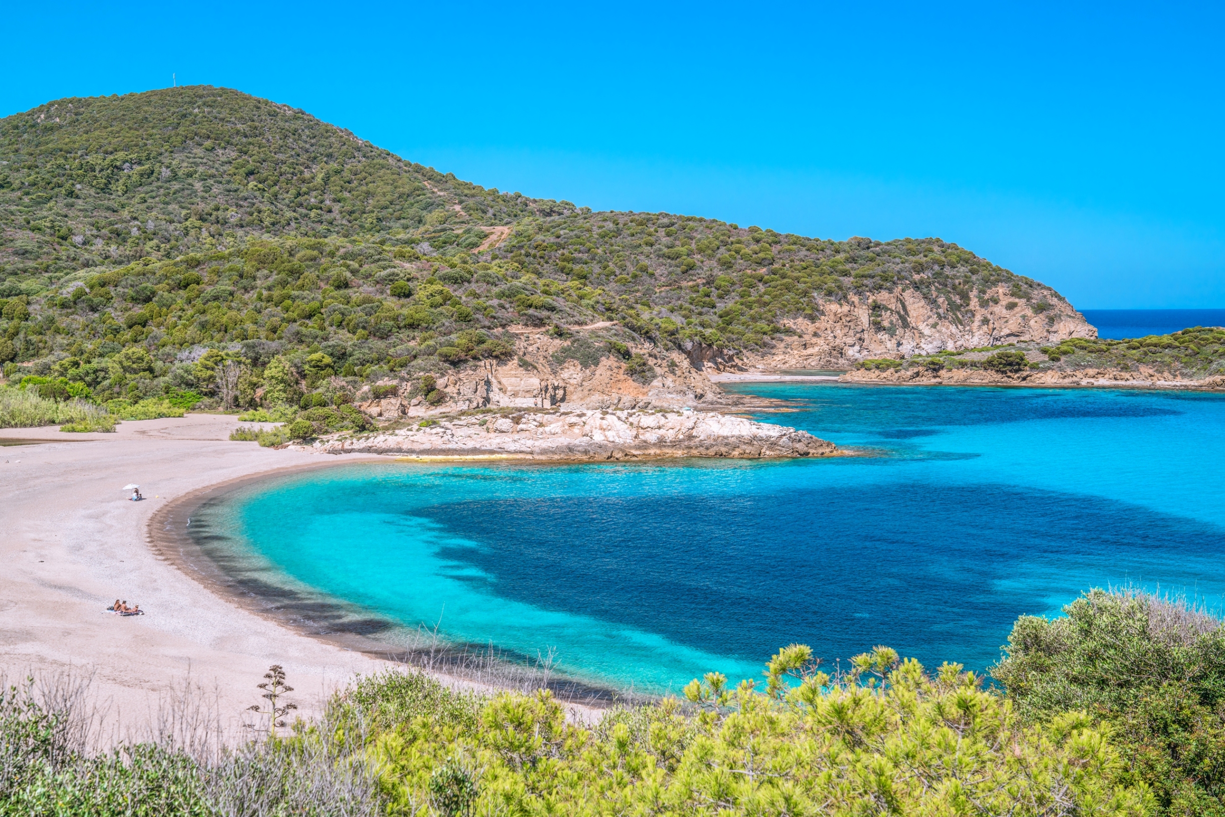
Along the Capo Malfatano stretch of coast, there is a combination of beaches with greyish sand, impervious cliffs and coves with amber-coloured sand, mixed with pebbles and rocks. The waters are shallow and transparent everywhere, with colours ranging from emerald green to turquoise. Of the beaches on the promontory, one very spectacular one that stands out is called Capo Malfatano, like the promontory, and it is situated between Tuerredda and Piscinnì. Along with Tuerredda, the beach that symbolizes the whole of Sardinia, and the splendid Porto Tramatzu, Cala Zafferano and the Dunes (or Is Arenas Biancas) in Porto Pino, it makes up the coastal treasure of Teulada.
It has medium-grain sand and pebbles, shallow waters and a sandy seabed, as well as inlets with amber-coloured rocks. The waters are always calm and take on a light blue colour, which becomes a deeper blue as you move away from the shore. Not surprisingly, the bay, which is sheltered from the winds, was chosen as a landing place in the 6th century BC, first by the Phoenicians and then by the Punics. Today, you can still see the great blocks of sandstone that formed the docks of the flourishing port, now submerged by the sea, but which can be discovered using a mask and flippers at a depth of just a few metres, close to the shore. In the western part of the beach there is a small beach establishment, from which boat trips set off along the whole coast.
Overlooking Capo Malfatano, there is a Spanish tower, behind which you will find a pond that makes the landscape even more evocative from the point of view of nature. From above, you will have a spectacular view of the nearby bays, particularly the little coves of Punta Tonnara to the west, which can be reached via a steep descent, towards the little island of Tuerredda and, in the distance, you can see the sea stacks of Capo Spartivento.
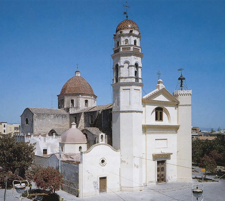
Las Plassas
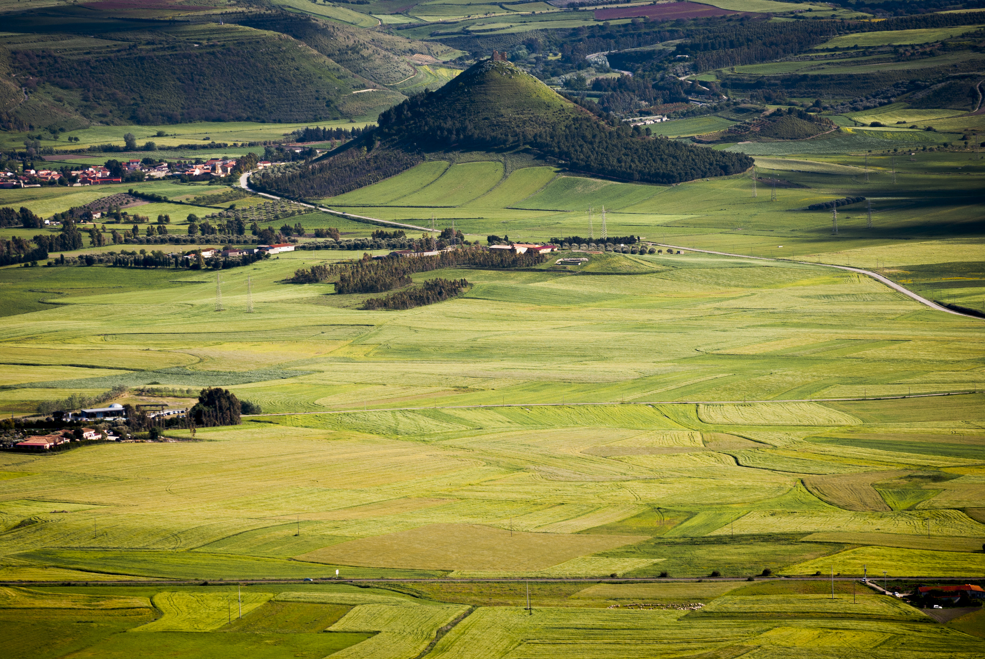
The town came into being during the Middle Ages at the feet of a castle as the groups of structures around it, sas plassas, came together to form a village. Las Plassas is one of the island’s smallest villages, with only 250 inhabitants. It rises in the fertile valley of the Flumini Mannu, its characteristic low houses graced with expansive courtyards nestled around the parish church of San Sebastiano, the patron saint whose feast day is celebrated in January with a huge bonfire. The church dates to the middle of the XVII century and has since been renovated. The town’s main church is Santa Maria Maddalena, a renaissance building constructed at the feet of the castle between the XVII and XVIII century over the ruins of a Byzantine structure. It had a Greek cross floor plan that was then changed into a Latin cross. The octagonal dome and bell-gable with a XVI century bell are all that remain of the original structure. On the outskirts is Santa Maria di Monserrato (late XIV century), home to a Nuragic Age sacred well. It was built in an historically frequented area, nearby is a Punic-Roman oven. Three cross arches divide the hall into four sections. The most heartfelt celebrations here take place on 8 September, while a yearly legume festival is held in late September.
The first outpost of the Arborea Guidicato, Las Plassas became the seat of the powerful Aragonese family, Zapata, its liege, who lived there until the late XX century. An example of the flourishing economy of the Middle Ages, the remains of the Marmilla Castle (or Castello di Las Plassas) are among Sardinia’s most picturesque, isolated on a lone and perfectly conical hilltop that looks out over the plains below. Built in the XII century, it was of military importance, the fortress of the Arborea Guidicato and a mainstay in the war against the Crown of Aragon, under which it fell after the sa Batalla at Sanluri (1409). Some of its rooms served as prison cells until the 1800s. The main tower, walls, perimeters and interior can still be seen today, as can the large well hewn into the rock. The connections between the rooms are worth noting. During archaeological digs some of the furniture, ceramics (XII-XVI centuries) and other relics were discovered, now on display at the MudA museum, located in an XVIII century residence. A multi-media route ends with a film about the visit to the castle by Mariano IV, the ruler, and will take you into medieval Sardinia. A part of the museum is archaeological. Of interest is an epigraph from the 1st century CE, when the local Uneritani population dedicated a temple to Jove. The village was then part of a Uselis colony. Many Nuragic monuments were reused in the Punic-Roman era. The most important of them are the single towered Perdedu and Bruncu e Forru, the five-lobed s’Uraxi and the XIX century BCE giant tomb of Mesedas. The area has been populated since the Neolithic Age, as proven by the Pranu Sonàllas site.
Baccu Mandara
A picture postcard sea, a well-equipped and accessible beach, surprising landscapes all around. The beach of Baccu Mandara occupies the eastern edge of the Geremeas coast, in the part of the locality belonging to the Municipality of Maracalagonis. It is a three-kilometre stretch of sand, partially interrupted by the mouth of a torrent that increases its flow and creates a lake a short distance from the shore, especially in winter. The small body of water divides Baccu Mandara from the beach of Marongiu and, at the same time, separates the territory of Mara from that of Quartu sant’Elena. On the opposite side, the limit is a small promontory that closes the beach with a rocky arch.
The sea is crystal clear, reflecting shades of light blue, and the sandy seabed slopes rapidly a few metres from the beach. The sand is light with medium-large grains. Behind it, thick vegetation surrounds the entire beach, on which there are also some small dunes peeping out. Baccu Mandara is particularly exposed to the winds, making it an ideal destination for sailing, windsurfing and kitesurfing enthusiasts, while snorkelling enthusiasts can explore the rocks at the foot of the promontory. The beach offers all the services you need: parking, refreshment areas, bathing equipment and boat rentals (pedaloes and canoes), a boat storage area, and it is accessible to disabled people.
While relaxing on the beach, you may notice that you have company: groups of ducks, who often stop off at the little lake formed by the mouth of the river. Remember not to leave before sunset, though, when the sun sets on the horizon, offering fantastic plays of colour, turning the shoreline pink and giving the sand a golden colour. Another surprise awaits you as you move past the cliff around the rocky spur on the left: behind it, a ‘hidden’ crescent-shaped cove, sheltered from the wind, opens up, with shallower waters and sand alternating with small and medium-sized rocks.
You can get to Baccu Mandara by taking the scenic provincial road leading from Cagliari to Villasimius, turning off at the signposted exit. The two previous diversions lead to the Geremeas beaches that share the same coastline, namely Kala ‘e Moru and Marongiu. The first, surrounded by rocks, has very fine, golden sand, waters with shimmering colours and shallow waters, while Marongiu alternates white and golden grains of sand and the sea here reflects shades of green and turquoise. In 2006, for the first time in Sardinia, a loggerhead sea turtle laid her eggs on a stretch of beach with sand dunes.
Porto Campana - Chia
A long stretch of soft warm golden sand, a wide sloped beach throws itself into a sea graced with hues of emerald green and turquoise. On either end are promontories covered in intensely aromatic Mediterranean vegetation, species of mastic and white cornflowers border the beach that faces the southern Mediterranean. Behind the beach are dunes that are home to ages-old junipers, cistus bushes and white sea lilies: this is how Porto Campana presents itself, a long and scenic beach with unique characteristics that set it apart from the many other coastal gems of Chia, a renowned tourist resort in the Domus de Maria area. This enchanting beach is extensive, graced by dunes covered with small shrubs that provide a stunning setting, a beach that is often used in advertising campaigns. The shallow water and the colours bring to mind tropical scenarios.
The water here is shallow, making it ideal for families with young children, who can play at the water’s edge in complete safety. A bit further out to sea is one of the most popular snorkelling and underwater fishing areas, rich in fish for all to enjoy. Behind the beach there is also a golf course and a resort. You can hire beach chairs, umbrellas, boats and dinghies, and get snacks and refreshments at any of several stands. The beach is a favourite of water sports enthusiasts, especially wind and kitesurfing, and water skiing. The ample parking lot makes it easy to get to the beach. Capo Spartivento, a habitat for grey herons, coots and egrets, is not far away.
An eastern cliff separates Porto Campana from the beautiful Cala del Morto cove, surrounded by pink granite rocks and blessed with fine golden sand. Further east, near the Chia lagoon, you will find Monte Cogoni and Sa Colonia, bound in by a promontory dominated by the Chia tower, at the base of which lie the ruins of the ancient Phoenician city of Bithia. Beyond the cliff are the beaches of su Portu and the wild and beautiful Isula Manna. To the west of Porto Campana is s'Acqua Durci and, separated by a small cliff, Su Giudeu, a spacious haven of super-fine white sand, considered the most beautiful beach of the entire south-west of Sardinia. It boasts an islet about a hundred meters away that can be reached on foot (or, at high tide, by swimming). The crystalline water here is almost unreal. The last beach west of Chia is Cala Cipolla, a small bay with a huge visual impact. In order to view the entire coastline, we suggest you take a walk to the nearby lighthouse that stands at the south-western extremity of Sardinia. The views from the top are breathtaking and it is often used as a backdrop for movies and advertising.
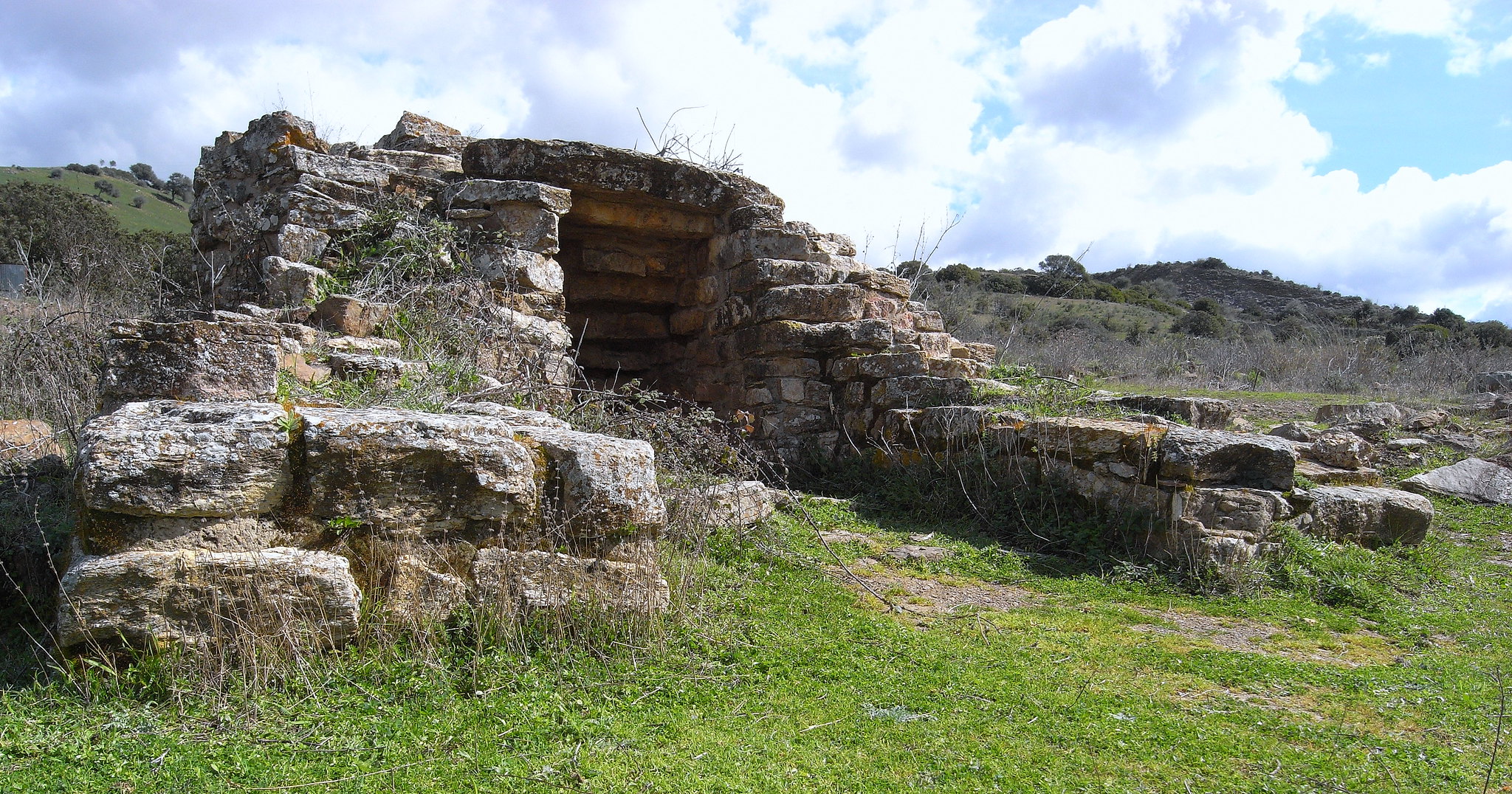
Funtana Coberta
One of the most celebrated, interesting and integral of the thirty-some Nuragic well-temples, where water worship was practiced, its name ‘fontana coperta’ (or covered fountain) well expresses its function and fine state of preservation. Three kilometres from Ballao, a town in the historic Gerrei region – along provincial road SP13 that goes from the town of Escalaplano - is the sacred well known as Funtana Coberta, nestled in a verdant valley floor closed in at its eastern end by a small hill.
The entire 10½ metres long building was built with freshly rough-hewn irregular limestone blocks of equal thickness, squared on the façade. The layout is unusual: two wings of different lengths give rise to an atrium whose original flooring can still be seen today. As with most sacred wells, it is divided into three parts. On the surface is a small, almost two-meter wide, open-air rectangular atrium (or vestibule), a stairway with twelve narrow steps, beautifully finished and covered by a stepped ceiling made up of twelve degrading architraves tucked into the walls to echo the line of the steps below, leads to the tholos-style room. The tholos is itself built in the shape of a small nuraghe, an almost circular 3½ metres wide subterranean room under a 5½ metres high false dome. The care with which the dome was made is remarkable. It has a drum wall where a protrusion marks the location of the stairway and the two wings of the atrium above. The slight convexity of the walls is also remarkable, it seems to beckon the faithful towards the inside of the temple. The floor is made of limestone slabs carefully laid down in a radial pattern. It is here that we find the actual water well, dug some five meters deep into the base rock and covered with 36 rows of stones, with an opening – about a meter wide - from which the spring water flows.
All that remains now of the elevated structures on the outside is the perimeter wall in the shape of a keyhole that encloses the atrium and the drum of the well. One metre from the main room, another rectilinear structure has been discovered, but not yet studied. The shape of the building is similar to that of many other sacred wells, for example the sanctuary of Santa Vittoria in Serri. Surprisingly, it bears a very close similarity to the sacred well of Garlo, a building from the 2nd millennium BC boasting almost the same structure and dimensions brought to light in 1981 in Bulgaria, ancient Thrace, 50 km from Sofia, close to the Aegean Sea. Amazingly, the two buildings differ by only a few centimetres.
The archaeological digs were begun in 1918 by Antonio Taramelli, and then restarted in 1994 (until the most recent activity in 2008), when it was possible to date the temple to between the 13th and 9th centuries BCE. Most of the finds consist of ceramic fragments from the Recent to Final Bronze Age. They are fragments of careened vases with oblique shoulders, hemispherical bowls and necked ollas. There were only a few finds of Nuragic crockery, most dating to the Roman Age. The bronze artifacts found are bits of ox hide, fragments of votive swords and small bronze pieces, such as the head of an archer, the ear of an animal and a foot with base.
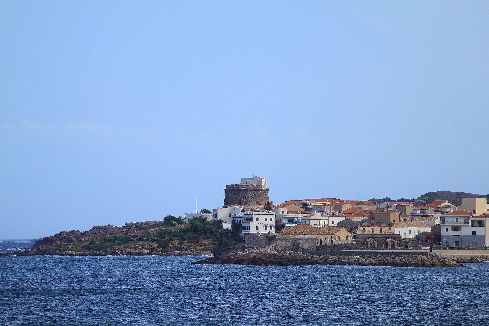
Portoscuso
Its port stands before the enchanting San Pietro Island and connects Sardinia to Carloforte, one of the major tourist resort islands. Portoscuso, populated by over 5,000 inhabitants, was founded in the late-16th century during Spanish domination, as a village based on fishing and coral miners hailing from Sardinia and also Sicily, Ponza, Marseille and Majorca. From the village of Puerto Escuso (‘hidden port’) grew an important commercial port, protected by a 16th-century tower in tuff and trachyte. Rising up on a hill, it offers wonderful views spanning from Cala della Ghinghetta to Portopaleddu (or Porto Paglietto), two beautiful coastal attractions with clear seas and fine sand. Next to the tower rising up in the mid-17th century is the Tonnara di Su Pranu.
Even today, the historic structure comes to life between May and June for Le Mattanze (traditional fishing activity) with the town, together with Carloforte, being famous for its tuna fishing. Built around Su Pranu throughout the centures were houses, warehouses for processing and the Church of Santa Maria d’Itria (1655), in honour of the patron saint of ‘tonnarotti’ (tuna fishermen) celebrated 50 days after Easter, with sporting events, music and folk dancing. Inside the Tonnara is the Church of Sant’Antonio da Padova. Not to be missed is the Sagra del Tonno (tuna festival), with delicious recipes to be savoured. Together with Sagra del Granchio (crab festival) in June, and the Arrusteddara featuring grilled fresh fish in mid-August, these are the major gastronomic events of Portoscuso. Not to be missed is the Villa Su Marchesu, of the noble Pes di Villamarina, baron of the Isola Piana, another ‘pearl’ of the Archipelago of Sulcis. Surrounded by mineral deposits and vineyards of Carignano, Portoscuso became an important industrial centre with the construction of the chemical pole of Portovesme in the second half of the 20th century. Its coastal territory, as well as soft stretches of sand including the unmissable Is Canelles, is characterised by scenic cliffs overlooking the sea, especially those of Costa Crobettana. The inland area has been inhabited since ancient times. The Domus de Janas of Guroneddu date back to the Neolithic age, the burial caves and megalithic circles of Su Medadeddu and Piccinu Mortu (later becoming a Punic necropolis) date back to the Copper age, whilst coming from the Bronze age are the sites of Punta Niedda and Stangioni (subsequently a Phoenician-Punic and Roman necropolis), along with the Nuraghic structures including Atzori and Bacu Ollasta surrounded by villages of huts. The area was frequented by Phoenician, Punic and Roman populations. The greatest archaeological remnants are in San Giorgio, with a Punic necropolis comprised of eleven sepultures (770-750 BC).
Burcei
Climbing up the eastern side of Monte di Serpeddì, at an altitude of 700 metres above sea level (compared to one thousand of the mountainous massif), is the town of southern Sardinia that has more characteristics and appearances of a mountain town. The name of Burcei, a Municipality of three thousand inhabitants, derives from burrei – a ‘herd of oxen’ – as a confirmation of the local pastoral tradition. The town arose towards the end of the 17th century when a number of families of breeders from Barbagia coming from Sinnai, Settimo San Pietro and Villasalto areas occupied the mountainous land, dotted with woods and springs, being particularly suitable for pastoralism, on which the local economy is still based. They settled near the spring Sa Mitza de su Salixi which, until the end of the 20th century, remained the centre of the town. The inhabited area preserves structures from the ancient Sardinian architectural tradition, which are clustered around three small piazzas. From the centre, an endless panorama can be admired, with views overlooking Cagliari and the Poetto beach.
The nearby countryside, as well as grazing, is used for vegetable gardens, grape vines, legumes, and above all, for its tasty and renowned cherries, protagonists of the local cherry festival in June. At the edge of the village, expanses of greenery can be admired for their fresh water springs, inebriating aromas and evocative views. This is the heart of the Parco dei Sette Fratelli, one of the largest and most fascinating natural oases of the island and of all of Italy. Along the valley of the Rio Brabaisu lies a forest of holm oaks and alders, inhabited by numerous species of rare animal species. Nearby is the Tuviois forest, which dates back hundreds of years. To the south of the town is the pretty gorge of the Rio Cannas, which flows between cascades, granite walls carved by water, and bushy and colourful oleanders. It is a land inhabited since the Bronze Age, as evidenced by the nuraghe edifices of Bruncu Entosu, Bruncu Moddizzi, De Su Attu, Dom’ e s’Orcu, Sa Serra and Su Nuraxi. Amongst the modern monuments, however, one highlight is the parish church of Nostra Signora di Monserrato, built in 1886 based on the design of the architect Gaetano Cima (a ‘design’ analogous to that of the Chiesa di Guasila) and characterised by an octagonal layout with side chapels, a neoclassical façade, being gabled and divided by columns, and featuring a tall bell tower. The patron saint of the village is celebrated on 8th September, whilst Santa Barbara is celebrated at the beginning of June. These are occasions on which to taste the specialties resulting from the local farms: excellent goat and sheep cheeses, exquisite cured meats and bread made from durum wheat semolina, cooked in a wood oven. Another unmissable event to taste delicacies is the Sagra de sa Pezza de Craba (a goat meat food fair) in August.
Perdaxius
It’s place name means ‘rocky or stone quarry’ and reflects the lay of the land and the abundance of rocky materials in the surrounding hills, including Monte s’Orcu. Perdaxius stands on a flat area crossed by a stream of the same name, in the heart of the limestone basin of Sulcis, an area rich in galena, once extracted in the mines of Peppixedda and San Simplicio. Now abandoned, they represented the town’s main income for centuries. Now, the town lives off shepherding, quality cheese making (goat and sheep milk cheeses); wine making (carignano, monica and cannonau wines); and the production of high quality leather, used by top designers. The local art of ‘bread making’ is closely linked to the cycle of life and celebrations: civraxu, cocoi, a bread with an egg typical of Easter, and pani de sposoriu, for important ceremonies, stand out. The local culinary traditions are also renowned, including excellent meats (beef, piglet, lamb, sheep and kid) and sweets, including bianchinus, gueffus, pabassinas, pardulas, pirichittus and pistoccus.
The Municipality of Perdaxius, independent since 1958, includes 14 small hamlets – Mitza justa, Is Manais and Is Pistis being the biggest – where about half of the 500 residents of the municipality reside. This reflects the town’s origins as a grouping of various isolated villages. The main village was founded after the year 1000 by Franciscan monks, conquered by the Pisans, passed under the control of the Giudicato of Cagliari and finally, under the control of the Crown of Aragon. Petrargio or Perdacha, abandoned by its residents in the 15th century to escape pirate raids, was repopulated and reorganized in the 18th century. The houses, which originally stood around a monastic settlement, now line a network of roads that gravitate towards the new Parish of San Giacomo (1959). A 13th century Pisan Romanesque church is also dedicated to Saint Giacomo, whose feast day is celebrated in late July (along with Saint Anna). Now restored, it has a façade of brown volcanic rock, topped with a bell-gable. It is the most important architectural site in the area along with the Romanesque church of San Leonardo, which stands in the town’s outskirts among century-old olive trees and has a façade rebuilt in the 17th century. Paintings dating to the Spanish period on the doors of the wardrobe housing the saint’s simulacrum are of note. Celebrations in his name are held on the Sunday of the Pentecost. Su Corrali, a Benedictine monastery in the hamlet of Pesus is also worth a visit.
The fertile lands and abundance of mineral deposits have drawn settlers since prehistoric times. The area contains the Camboni Nuraghe, not far from the town, and the nuraghe of Mount s’Orcu. Traces of burials in natural cavities near Su Moinu de Perdaxius also date to the Bronze Age.