

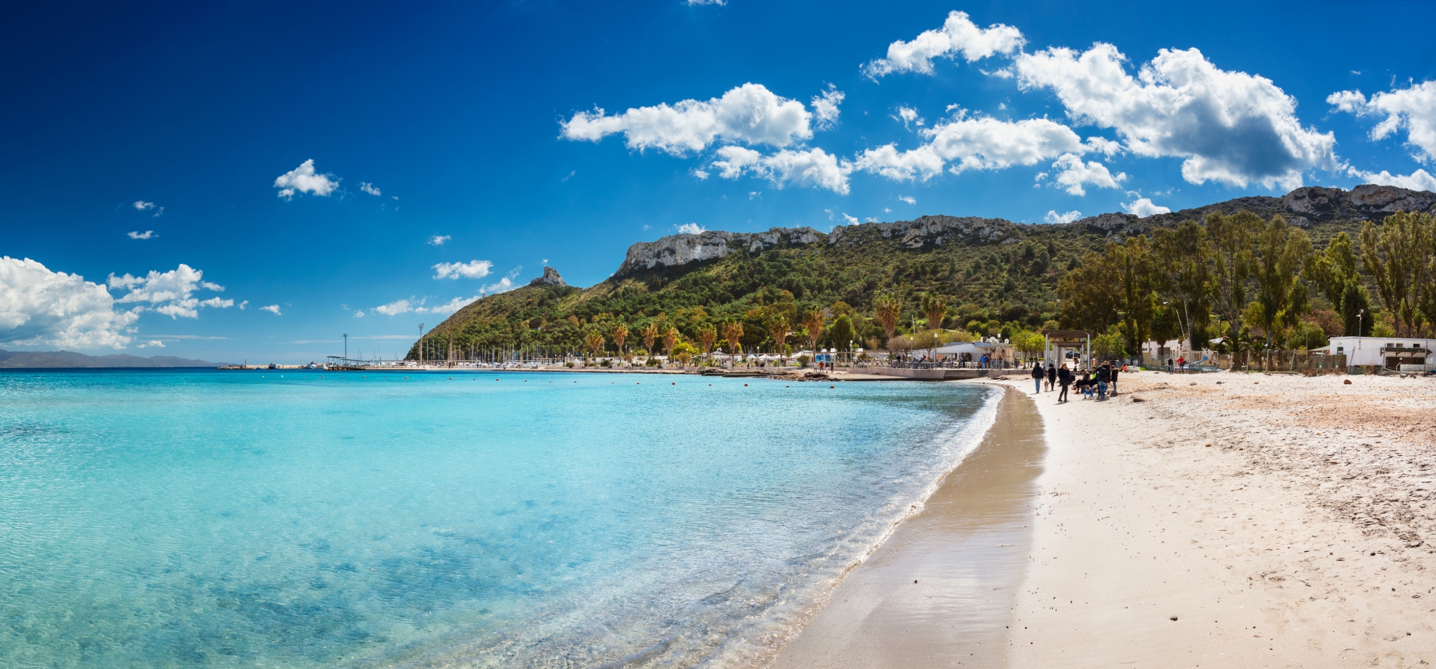
Torre delle Stelle
In the evening, the lights of the villas illuminate the cliff like a starry sky and reflect on the calm, clear waters of the sea, with its surf gently breaking on two strips of soft, light sand. The two white expanses separated by the spectacular promontory are Cann’e Sisa and Genn’e Mari, the beaches of Torre delle Stelle, a seaside village reflected in the eastern side of the Golfo degli Angeli and part of the territory of Maracalagonis, centre of the metropolitan city of Cagliari.
Cann’e Sisa is oriented towards the west, i.e. towards the capital and, compared to its ‘twin’ Genn’e Mari, it has more greenery surrounding it, thanks to the pine forest behind the beach. The sand is white, the sea reflects shades of blue and green, the water is shallow and suitable for children, while the crystal clear water is an irresistible attraction for snorkelling enthusiasts. All services are available to bathers, including those linked to accessibility.
Beyond the cliff, proceeding in an easterly direction, lies Genn’e Mari, ‘gateway to the sea’ translated from Campidano dialect: the water is equally shallow, while on the beach, there are a few pebbles peeping out between the grains of sand. This stretch is also equipped for every need and is frequented by kite and wind surfers when it’s windy. Both beaches are a destination for underwater fishing enthusiasts.
In the promontory around the beaches, the residential complex of Torre delle Stelle, the development of which started in the 1960s, comes to life especially in summer, thanks to the beauty of the sea and the events organised in the village. However, the area near the coast deserves to be visited throughout the year, especially by those in search of an oasis of peace and fascinating views of nature; here, myrtle bushes, junipers, olive trees, lentisks and eucalyptus trees form a border along the paths behind the beaches.
Torre delle Stelle is a popular destination and also an excellent starting point for exploring the coast of southern Sardinia, with its renowned resorts and intimate little coves with their wild charm. Nearby, to the west, you will find the beaches of Geremeas: Kal’e Moru and Baccu Mandara, with golden sand and a sea with turquoise reflections. To the east, there is the wide coastline of Solanas, a coastal district of Sinnai, surrounded by Mediterranean scrub and iridescent waters. Moving beyond, from Capo Boi, the splendid coastal stretch of the famous tourist resort of Villasimius begins.
Sella del Diavolo
Its unmistakable profile is one of Cagliari's most characteristic features, leaving an impression due to its particular shape and dominant position on the Poetto beach. The Sella del Diavolo (Devil's Saddle) occupies the exact centre of the Golfo degli Angeli (Gulf of Angels) and is the offshoot of the Sant'Elia hill that reaches out to the sea. For decades now, the promontory has been a favourite destination for trips just a stone's throw from the city centre, ideal for hiking, even at night, with surprising traces of human habitation that have alternated over millennia, and an irresistible attraction for the view from its summit. The scenery is so impressive that, according to legend, even heavenly and demonic hosts fought over it. The myth is told in two slightly different versions, particularly in terms of the reason for the 'heavenly battle'.
According to the most popular version, the devils were enthralled by the place and tried to take possession of it. According to the variant, however, it was the angels who asked God for this enchantment, chosen for its purity and absence of evil, as a gift, triggering Lucifer's jealousy. The battle took place in the skies above the coast of Cagliari and saw the victory of the army of angels led by the archangel Michael. During the battle, Lucifer lost his saddle, which fell and turned into rock, giving rise to the promontory. This gave rise to the name Sella del Diavolo (The Devil's Saddle) and also the name Golfo degli Angeli (Gulf of Angels), as the inhabitants of the large inlet wanted to name it after their saviours.
Paths branch off from the square next to the small beach of Calamosca or from the small port of Marina Piccola, allowing you to explore the promontory, offering unmissable views of the landscape, up to, on clear days, Capo Carbonara, including the view of the twelve kilometres of Poetto and its promenade and, behind them, the profile of the Molentargius-Saline Park. Along the way you will notice European fan palms, junipers and wild olive trees, as well as mastic trees and euphorbias. The promontory also offers shelter to rare birds, such as peregrine falcons, kestrels and Sardinian partridges. It is also not uncommon for foxes and wild rabbits to appear in the bushes.
The natural cavities around Capo Sant'Elia have yielded traces of habitation since the Neolithic period. On the highest point are the ruins of a Punic temple dedicated to Astarte, as testified by the discovery of a slab preserved in the Archaeological Museum of Cagliari. You will also see two cisterns, one of Punic origin, larger than the second from Roman times. A perimeter of foundations leads back to the former church of Sant'Elia, most likely built in the 11th century by the Vittorini monks together with their monastery. According to tradition, the saint was martyred on the hill. The watchtower, part of the coastal defence system against Saracen raids, is of Spanish origin. In Catalan it was called pouhet (‘little well’) and the name Poetto is thought to derive from this. Finally, some military structures, including a blockhouse that you will encounter along the way, date back to the Second World War.
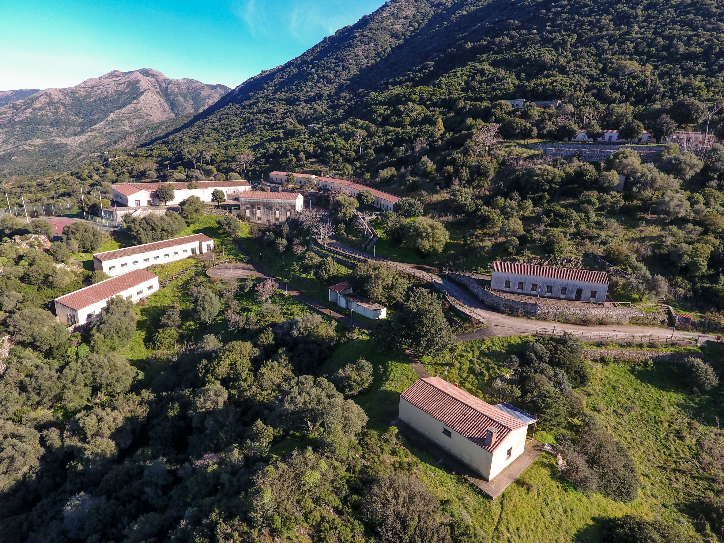
Mining village of Orbai
Paradoxically, its most captivating feature, that of being located in the middle of a lush forest with a splendid view of the Cixerri river valley, contributed to its decline, until it closed down. Its isolated position, the difficulty in reaching it and the consequent excessive cost of transporting lead, zinc and barium extracted from its quarries, together with the collapse of their price on the international markets, meant that the gates of the Orbai mine already closed in the 1950s. Today, abandoned buildings remain, bearing witness to a historical period that saw the emergence of dozens of small workers’ villages around wells and tunnels throughout the Sulcis – Iglesiente and Guspinese areas, characterised by the hard work of the miners and the continuous coming and going of people and means of transport, after which it entered a melancholy decline towards the last decades of the 20th century.
The village of Orbai is located on the slopes of the mountain of the same name, in the territory of Villamassargia, and was active for about 80 years. The first concession dates back to 1872, in favour of a company known as ‘degli Orbi’, which is where Orbaigets its name. An English company, United Mines Ltd, then an Italian-French company, Pertusola, were entrusted with it, building a small village and a washing plant. In 1943, the concession passed to the ‘Orbai mine’ company, which built a modern flotation system. Following an unsuccessful relaunch attempt in the early post-war years, the mine was closed and the concession was considered to have ceased to exist for good in 1968. Today, you can see the area of accumulation of flotation sludge and, not far away, the remains of the washing plant and furnace. Continuing along the path that branches off between holm oaks and strawberry trees, you will come to the village, with the recently-restored buildings that originally contained the management offices: along one side there are the houses intended for the miners, many of which have never been lived in.
You will come to Orbai by following provincial road SP 2 towards Villamassargia and taking the signposted diversion on the left. Alternatively, you can visit Orbai as the second stage of a tour coming from the mine of Rosas, in the territory of Narcao, along a route that stretches eight kilometres into a dense forest. Rosas is an open-air industrial archaeology museum, where a washing plant with a wooden roof stands out, in which there is a museum exhibition.
In the territory of Villamassargia, there is not only industrial archaeology, but also prehistoric traces dating back to the Bronze Age, as shown by the Santu Pauli and Monte Exi nuraghi and the Giants’ Tombs of Monte Ollastu. The town played an important role in the age of the Judicates, when the castle of Gioiosa Guardia was built, a ‘lookout’ over the Cixerri valley and the park of centuries-old olive trees s’Ortu Mannu, dominated by sa Reina, a natural monument with a trunk that has a 16-metre circumference.

Beata Vergine Assunta - Guasila
The inspiration for its shapes brings to mind the Pantheon in Rome and Palladio’s architecture. It is the main place of worship in Guasila, the heart of the village, and it is a true temple with an imposing and, at the same time, elegant appearance, built in that neoclassical style so dear to its designer, architect Gaetano Cima. The Parish Church of Beata Vergine Assunta dedicated to the Assumption of the Blessed Virgin Mary was designed in 1839 but building began three years later and was completed in 1852. It has an octagonal layout and you can enter the central body through a pronaos with six Doric columns, preceded by a stunning staircase. The tympanum is supported by two corner pillars.
The building was constructed on the site of a previous place of worship; in fact, the bell tower next to the façade on the right dates back to the 18th century. Inside the church hall, you will be impressed by the domed vault, with decorations that have geometric and floral motifs stretching from the base of the dome to the centre, closed by a skylight. The walls are punctuated by eight columns and six chapels open up between them, two of which are main ones. In the first, dedicated to Santa Maria, there is a statue depicting the dormitio virginis and a simulacrum of Saint Peter the Apostle that, according to tradition, comes from the village of Sennoru, one kilometre from Guasila, that later disappeared. On the days preceding the celebration of the patron saint, the dormitio virginis is the protagonist of a dressing ritual of Byzantine origin: the simulacrum is placed on a golden bed, sprinkled with oils and perfumes and dressed in sumptuous clothes and with is prendas, jewels and a silver crown. The statue is then placed in the centre of the sanctuary. The second main chapel is dedicated to the body of Christ and contains a simulacrum attributed to Antioco Lonis, a sculptor from Senorbì active in the 18th century. The presbytery, separated from the church hall by a marble balustrade, contains the main altar made of multicoloured marble. In its central niche, you can admire the statue of Our Lady of the Assumption between two angels. At the foot of the tabernacle, the remains of Saints Primo, Engrata and Benigno are kept in a walled-in urn, placed under a black stone. Items that come from the old parish church of Guasila include a baptismal font, a holy water font and a pulpit made in the early 19th century.
On the right of the temple, built as a diocesan sanctuary in 2002, you will see the Oratory of the Rosary. Its building dates back to the 18th century, while sources report that there was already an oratory operating in Guasila in the 16th century, with the name of Obraria de Nostra Senora del Rosser. A few steps away from the church, you can admire the precious liturgical items, vestments, reliquaries and the votive offerings from the sanctuary exhibited in the museum of Scrinia Sacra, located in the rooms of the building that was once a prison, then a town hall and today a place of art and culture.
Torre Salinas
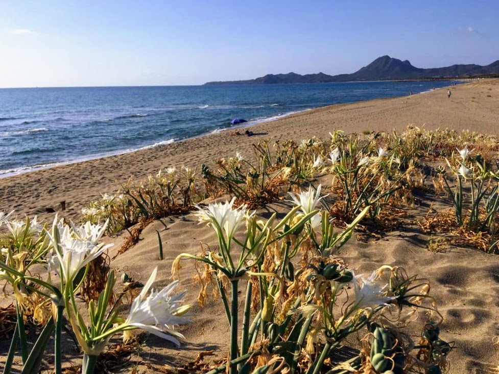
White cliffs, long stretches of white sand, dunes covered in Mediterranean greenery, crystal clear seas and ponds full of ‘life’. The Muravera coast is a succession of beautiful scenarios, never the same yet perfectly in tune with each other. About six kilometres from the main town in the Sarrabus area, a promontory overlooking the sea offers spectacular views of the entire nearby coast and ‘embraces’ Torre delle Saline. At first glance, the ancient fortress reveals an unusual feature: it is the only one belonging to Sardinia’s coastal defence system to have a square layout. At its base, the beach of Torre Salinas stretches to the north and obviously gets its name from the building dating back to the Spanish era. The beach is very broad, reaching a hundred metres in width in some places, and it is characterised by the ochre-golden colour of the sand. Sea lilies pop up on the dunes behind it and even further back there is thick Mediterranean scrub. The sea will surprise you with its crystal-clear waters and various shades of colour: blue alternating with green tones. The beach is never excessively crowded, thanks to its size, and it has convenient parking and refreshment areas, with the possibility of renting deckchairs and beach umbrellas.
The access road to the coast runs alongside the Saline pool behind it, one of the wetlands making up the Pools of Sarrabus complex. Birdwatching enthusiasts gather here, to observe numerous bird species: great egret and purple heron, black-winged stilt, osprey, mallard, kestrel, buzzard, Barbary partridge and, above all, the pink flamingo. A path that climbs the promontory to the right of the beach will take you to the fortress, built on three levels, probably around the mid-17th century, to protect the salt marshes and surrounding territory and to act as a lookout for the barbarian incursions that plagued the coast. The building was in visual connection with the towers of Dieci Cavalli and Capo Ferrato and underwent renovation- with the plastering of the external walls - at the beginning of the 2000s. From the tower, an enchanting landscape will open up before your eyes, with the lagoons surrounded by greenery, the elevations of the Nieddu Mannu plateau in the background and two spectacular stretches of golden sand on the sides of the promontory. To the north, the coast blends into the beach of San Giovanni and continues to the mouth of the Flumendosa. To the south, the small stretch called Cristolaxeddu makes way for the magical ‘bronze’ scenery of Colostrai and Feraxi.
Porto Sa Ruxi
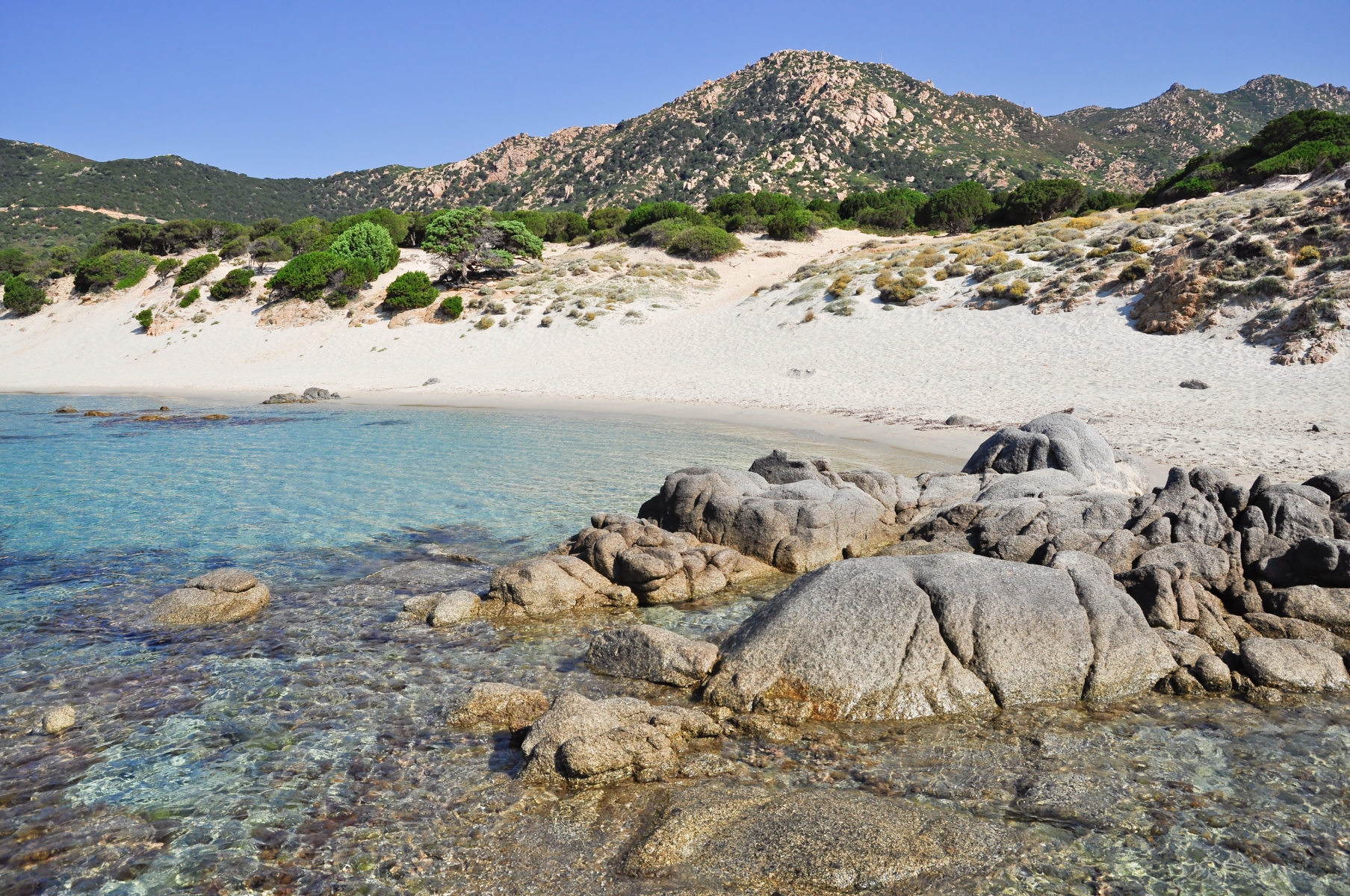
Looking at it from above, you will immediately notice its unusual three-arched form: in reality, more than a single beach, it is a group of three little coves with crescent-shaped outlines, separated from each other by flat granite rocks. However, its appearance is not the only feature that makes Porto sa Ruxi captivating: the beach is surrounded by wild nature on the outskirts of Villasimius, in a setting of cliffs and rock faces. Behind it, there are sand dunes covered with age-old junipers, maritime pines and fragrant myrtle bushes, which you can admire as you walk along the path connecting the car parks and the coast. The sand is soft and white, while the sea will surprise you with its transparent waters reflecting shades of bright blue and turquoise. The shallow waters and the shelter from the northwesterly wind offered by the hills behind it make the beach suitable for families and children. Furthermore, it is a destination particularly popular with snorkelling and diving enthusiasts: its waters, included in the protected marine area of Capo Carbonara, are rich in fish fauna populating the area around the rocks in particular.
In Porto sa Ruxi, there are refreshment areas and beach equipment and boat rental services, as well as a car park a few dozen metres from the beach. You can reach it by following provincial road SP 17 towards Villasimius, after passing the seaside village of Solanas – which falls within the territory of Sinnai - and Capo Boi, taking the exit indicated and travelling along a short stretch of dirt road. You will already see the intense colour of the sea and the charm of the cliffs surrounded by Mediterranean scrub from the coastal road that, further on - after passing a small village with the same name as the beach - proceeds along the coastline, allowing access to other wild coves, among which Cala Piscareddus, two hundred metres of light sand and rocky outcrops in front of a sea of emerald green reflections.
Continuing in an easterly direction, you will see the ‘gems’ of the Villasimius coast appearing one after another: Campus, near the mouth of a small river, is a wide expanse of soft white sand. Then there is the beach of Campulongu, surrounded by thick vegetation; next to the tourist port, and the beach of Riso, with its characteristic rice-like ‘grains’ of quartz sand. Beyond the promontory of Capo Carbonara, the unmissable destinations are called Porto Giunco, Cala Caterina, Simius and Punta Molentis.

Torre dei Dieci Cavalli
From an architectural point of view, it is one of the most beautiful coastal towers on the Island and it is certainly the one with the most original shape: to fulfil the purpose of protecting what was then a ‘gateway’ to the town of Muravera, it was not built next to it, but literally over it. It is no coincidence that the tower of the Dieci Cavalli (Ten Horses) is also known as the ‘tower of the gateway’. The building is located in the locality of San Giovanni, in a place that was an obligatory passage, in ancient times, along the ‘royal road’ leading to Muravera and the villages of the Sarrabus hinterland, coming from the southern coast, because along the sides there were - and still are in part - ponds and marshy areas that are difficult to cross.
The year of construction is not known, but in 1581 the tower was already operational, functioning as a watchtower and for light defence. It owes its name to the fact that it was constantly manned by a force of ten mounted guards, ready to gallop to raise the alarm in nearby villages if pirate ships were spotted. In fact, the barbaric raids constituted a devastating scourge in the Sarrabus region between the 16th and 18th centuries. The fortification consists of three building elements. The first is the doorway itself, nine metres wide, six metres high and five metres deep. The two sides of the doorway have arches of different shapes: pointed arches on the side facing Muravera, while the side facing south, which is where the attackers came from, has a depressed arch and a narrowing, with jambs and slabs embedded in the ground. The door serves as a base for the tower, which is about seven metres high and with a circular form. The diameter is aligned with that of the door. Access was from a door located to the west, via a staircase that was then pulled inside. The remains of a curtain wall are the third architectural element and are visible on the west side of the tower. Along the wall, you will see a series of embrasures used by the guards.
The sea is a few hundred metres away. In front of the tower, the long, narrow beach of San Giovanni opens up. Thanks to its size, it is never too crowded and features soft, light sand, eucalyptus trees close to the beach - under which you will find some shade in the hottest hours of the day - and the crystal-clear sea with hints of emerald green. Next to it there is parking, as well as refreshment areas and beach equipment rentals. About 800 metres north of the tower, stands the building that gave the town its name: the little country church of San Giovanni. Its origin is probably Byzantine and it was abandoned and renovated several times, with the last renovation taking place in 2005. Its stone structure, with a longitudinal form, a wooden architrave and sloping roof, is surrounded by greenery.
At sailing school
Take note: sailing schools are reopening safely. There are only a few lessons on land, as sailing is taught on board. You soon learn, hands-on, how to steer boards and sails, from the easiest to manoeuvre to the most demanding, from the agile 'single-seater’ laser sailboat, wind and kite surfing boards, to boats with movable centreboards, where bowman and helmsman work in unison with daring bowlines and acrobatic trapeze harness sailing, and romantic cruise boats. As soon as you reach the sea, you will learn to listen to the atmosphere around you spontaneously and, as if by magic, an intimate physical bond is created with the sea and the wind, a relationship that is difficult to break.
All you need to do now is choose where to learn to ‘go sailing’. There are plenty of schools along the Island’s coasts, from the gulf of Cagliari to that of Asinara, from the gulf of Orosei to that of Oristano, from the Maddalena Archipelago to the islands of Sulcis and from the Gallura coast to the Riviera del Corallo. You can find them close to the most frequented beaches and in nautical clubs based in ports and tourist landings. If you are ready for a full immersion experience, the most prestigious sailing centres are at your disposal. Find your ideal school. It is worth trying your hand at the oldest form of navigation, the most poetic one, the one most in harmony with the Sardinian sea: it will be the most exciting part of your holiday!
Turri - Sant'Antioco
It is divided into three inlets, all with different shapes, washed by an enchanting sea and a watchtower up above. The beach of Turri is located in the southeastern corner of Sant’Antioco, the largest island of the Sulcis archipelago, 15 kilometres from the town of the same name: its landscape makes it a destination not to be missed during a tour of the beaches of Sant’Antioco.
On the slopes of Capo su Moru – meaning ‘the Moor’, symbolising the fact that it was a landing place for the Saracen pirates -, you will find the first of the three coves on the eastern side. It is a few dozen metres long, crescent-shaped and protected by two high cliffs. Its golden sand is mixed with small pebbles. On the opposite side, there is a strip of light-coloured sand, mixed with dark pebbles smoothed by the sea. Further west, you will find the third, and the widest, stretch of coastline with larger pebbles and a transparent sea that, along with its turquoise and cobalt blue colour, also has hints of emerald green from the reflection of the sun’s rays on the dense Mediterranean scrub that spreads here to the point of almost overhanging the sea. Turri is a destination loved by snorkelling enthusiasts, thanks to the transparent waters of the seafloor and the wealth of fish fauna, and by surfers, especially when the south-westerly “libeccio” and the westerly “ponente” winds blow.
A short path will lead you to the top of su Moru, where the tower of Cannai stands. The fortress was built in 1757, immediately after the Torre di Calasetta, to remedy the fact that during the Spanish domination the two islands of Sant'Antioco and San Pietro had not been equipped with sighting facilities. The truncated cone tower has a circular room inside it with a flight of stone steps leading to the parade ground, where artillery and a sentry box were located. From here, it was possible to monitor the gulf of Palmas and spot any dangers for tuna traps and salt pans. The alarm was signalled from this tower during the attempted French invasion of 1793 and, later on, for the Tunisian attacks in the early 19th century, before falling into disuse in 1867. From the promontory, you can observe the island’s cliffs and the outline of the islets of Vitello and Vacca, as well as the flight of cormorants and peregrine falcons.
To reach Turri, you will pass the beaches of Maladroxia and Coaquaddus, the two ‘jewels’ of the eastern side of Sant'Antioco. The first, where the Blue Flag flies, has fine, white sand with a few pebbles and waters reflecting shades of green and turquoise. At Coaquaddus, the sand is framed by spectacular limestone cliffs as it plunges into the blue sea.
Nuraghe Barru
It once defended the surrounding territory and it now preserves the memory of its ancient inhabitants, gradually telling the story, during the excavation campaigns, of intricate events and each time providing some pleasant surprises. From high up on a limestone elevation, the nuraghe Barru dominates the plain below, divided in half between the Municipalities of Guasila and Guamaggiore. The view from the monument extends from the two villages to the mountains of Segariu and the village of Villamar. It was built in several phases, using squared blocks of limestone marl placed in even rows. The excavation campaigns have brought to light a complex structure, made up of a central keep, facing north, and two towers positioned around a courtyard and connected by curtain walls.
The keep has an elliptical layout, typical of a proto-nuraghe, so it is likely that the central tower represents the original nucleus and that the lateral towers and the walls were built at a later time. The area so far investigated stretches for three thousand square metres, but the village may have been much larger. Along the curtain wall, you can see a system of steps and several silos, which are thought to have been used for storing agricultural products.
The nuraghe Barru is still a fascinating enigma, due to the numerous interventions - not only of extension, but also to resize the spaces -, with structural modifications, repeated design changes and renovations already carried out in ancient times, making it complicated to reconstruct its history. Adjacent to the east tower there is a small room, the use of which is still a mystery. The third tower, facing south, has a slightly smaller diameter than the other two. Inside a small room, created in the thickness of the wall, on the west side of the courtyard, there is a cistern-well, where animal and human bones, ceramic fragments and a few containers in excellent condition were found. You can access the room through an architraved entrance that opens onto the courtyard, and you will also notice a narrow staircase leading to the upper level.
The fortress took on religious functions, probably at the beginning of the Iron Age: this is shown both by the type of ceramics found in the well and the discovery of a storeroom with bronze artefacts and votive swords placed in an orderly manner and carefully sealed. To the north-east of the central body you will notice the traces of other structures, belonging to the village of huts, mostly still to be investigated. The last mystery of Barru concerns its fate: no significant quantities of materials from after the Iron Age have been found and there are no traces of destruction of the building, so the most plausible theory is that it was abandoned, for some obscure reason, and destined to be buried by sediments for thousands of years, before emerging again three thousand years later.