

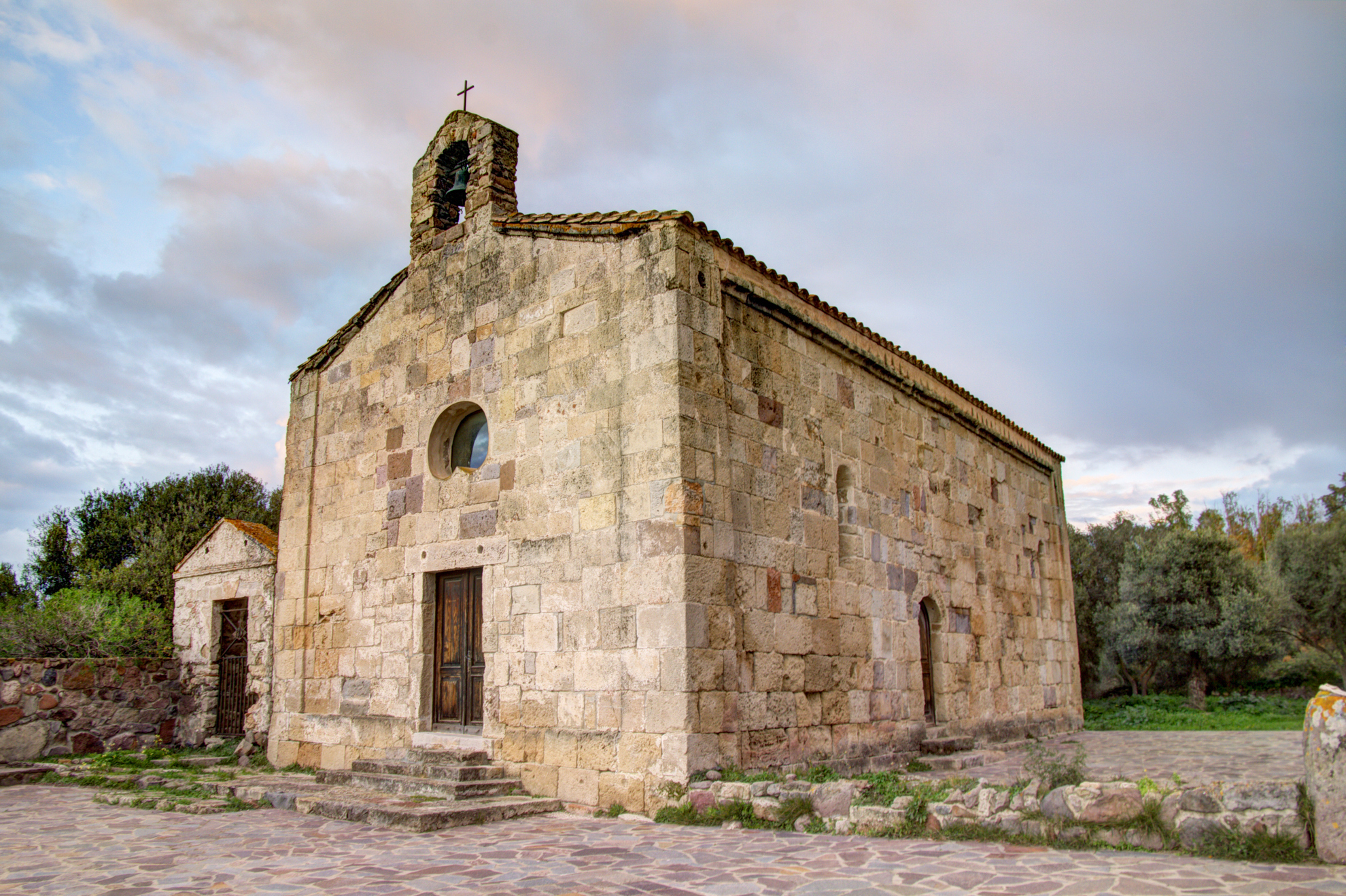
Santa Giusta - Castiadas
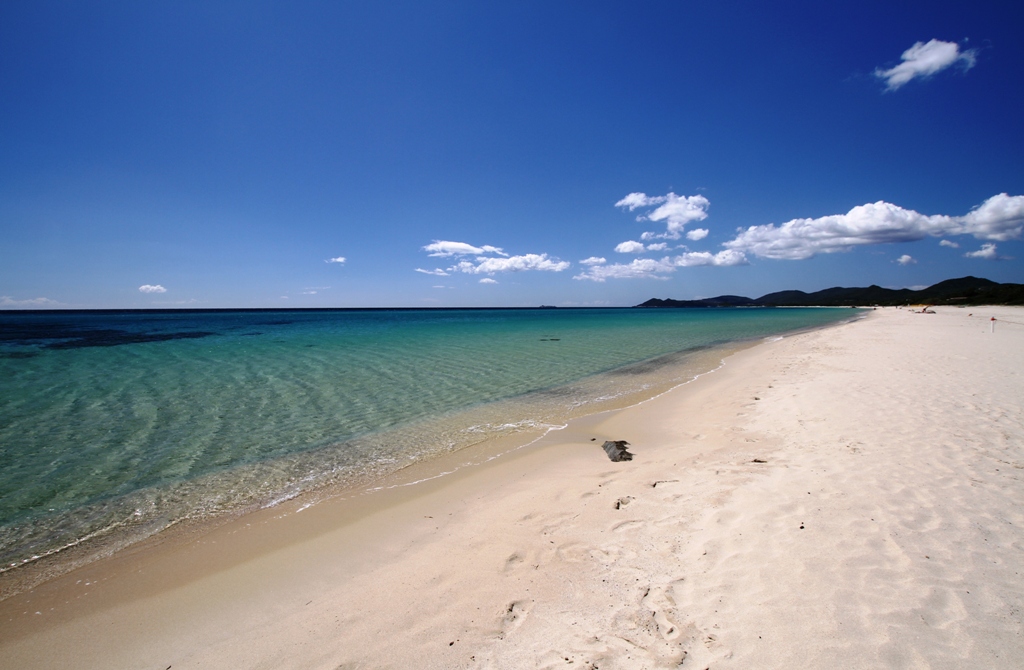
To the north, the last beach of Castiadas is part of the Costa Rei coastline, confirming all of the area’s most charming characteristics, with a few extra distinctive traits. Santa Giusta consists of a beach about a kilometre long, also known as the beach of Villa Rei, and by a decidedly smaller cove, framed on one side by a small promontory and on the other by a white granitic outcrop known as the Scoglio di Peppino (Peppino’s Rock), with a shape resembling a tortoise. The ‘rock’ marks the border between the coastal territory of Castiadas and that of Muravera and it is one of the main attractions of the Costa Rei. You can lie on its ‘back’ to sunbathe, stop to take some striking photos and practice a few dives.
The sand of Santa Giusta is soft and white, almost impalpable, with golden reflections and a few grains of shingle. The crystal clear sea will enchant you with its turquoise colour and hints of emerald green, thanks to the sunlight as it reflects on the surrounding vegetation. The waters are shallow and get deeper gradually, making the beach safe for children and allowing the water to warm up quickly, resulting in a ‘swimming pool effect’.
In the northern cove, you will also see a sand dune covered in sea daffodils and, behind it, a ‘crown’ of junipers. Not surprisingly, the stretch of coast between the little beach and the promontory was declared a site of community interest and is part of the Natura2000 network.
Thanks to its beauty, colours and surrounding view, the beach of Santa Giusta is chosen by numerous couples every year as a location for their wedding. The ‘sacred’ aura for the fateful “yes” is accentuated by the presence of a bronze statue at the top of a small promontory, depicting Christ blessing, facing the sea.
The southern limit of the beach is marked by a rocky strip that interrupts the beach and ‘plunges’ for a few metres into the sea. Beyond, you will find the beach of Cannisoni, also characterised by light sand and a crystal clear sea. Further south, there is the coast of Sant’Elmo. Then there is the splendid cove of Monte Turno. On the other side, after Peppino’s Rock, you will enter the long coastline (eight kilometres) of Costa Rei, which is part of the Muravera territory.
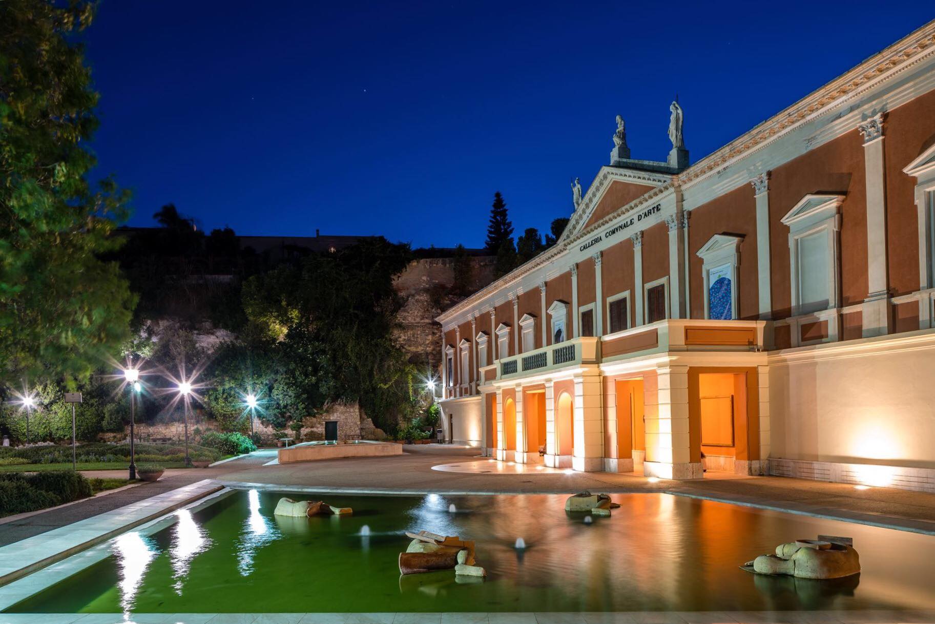
Municipal Art Gallery
One of Cagliari’s most beautiful green areas stretches across a ridge of the Buoncammino hill: a sort of ‘hanging garden’, with a long, spectacular tree-lined avenue. At the end of the avenue, you will notice the elegant Neoclassical façade of the former royal munitions depot, which has accommodated the Municipal Art Gallery since 1933. The military building was destroyed by an explosion and was rebuilt in 1828 based on a design by military engineer Carlo Boyl. After a century of use as a barracks and a warehouse and after further modernisation works, it became a museum. After crossing the garden, before entering, you can admire the façade of the building, with limestone friezes and a tympanum with three statues carved in Carrara marble above it.
Inside the ‘gallery’ there are two main exhibition areas: the first is the Ingrao collection, donated to the Municipality of Cagliari in 1999, which contains works by the greatest Italian masters of the 20th century, including Umberto Boccioni - with 31 works including paintings and drawings -, Giorgio Morandi and Mino Maccari. About 650 works form a collection of the main artistic trends of the last century and are kept in the rooms called ‘the collector’s rooms’. In the second area, you can admire the most important collection of works by Sardinian artists, especially between the early 20th century and the late 1970s. The artists represented, including the main personalities on the Sardinian artistic scene, went on a search for harmony between the ideas of contemporary art and the island’s cultural context. One room is dedicated to the plaster sculptures of Francesco Ciusa, including the famous ‘madre dell'ucciso’ (mother of the slain). Among the 74 works on show, there are also creations by Pinuccio Sciola, Costantino Nivola and Maria Lai. A collection of Sardinian ethnographic materials from the late 18th century and a large collection of prints are also on display.
The ‘gallery’ also accommodates the library specialised in the history of art and the ‘Reading Garden’, an initiative that allows you to borrow books and newspapers and read them outdoors. Educational courses, activities for children, meetings and cultural reviews are periodically promoted. The rooms are accessible to the blind.
The cultural itinerary can continue to the fortifications of the Castle district, crossing the spectacular Porta di San Pancrazio, to reach the Citadel of Museums, the ancient site of the royal arsenal and today the largest museum centre in Sardinia, which includes the National Archaeological Museum, the Museum of Siamese Art, the Anatomical Wax Museum, the Ethnographic Museum and the National Picture Gallery.
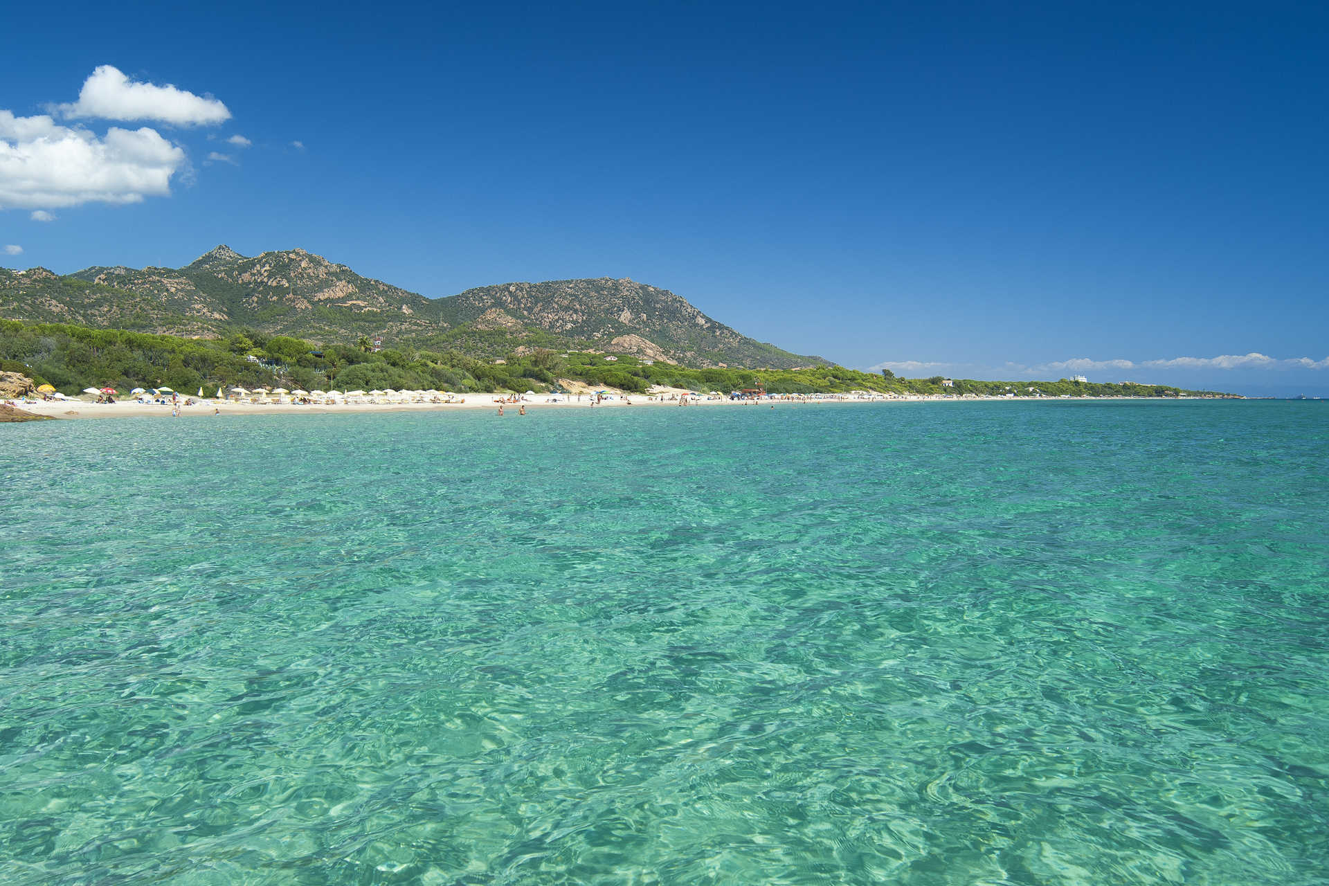
Santa Margherita di Pula
Almost ten kilometres of soft, golden sand lapped by shallow, warm waters in tones of green, with a sea that is so clear you can see right to the bottom even without diving. Santa Margherita is a pearl of southern Sardinia, the symbol of Pula, which extends to the west as far as another feature of the island, the coast of Chia (in the territory of Domus de Maria).
Santa Margherita di Pula is composed of a series of bays and beaches, almost uninterrupted, divided only by the rocks of small promontories, named according to the area (including Cala Marina and CalaBernardini), overlooking numerous luxury resorts including some which are among the island's most renowned, a destination for film and television stars, sports celebrities and top financiers.
The beaches are reached by small access roads next to the hotels or through the pine woods behind them, where you'll find hidden apartment blocks, villas and holiday homes. You'll discover unforgettable places, coves with super-fine, white tongues of sand, dotted with pink granite rocks, while the pines offer shade from the summer heat. The area is swept both summer and winter by a wind much appreciated by surfers. The sea bed is well-known among snorkelling and underwater fishing enthusiasts.
A short walk from Santa Margherita is the Pula nightlife, with its numerous events and aperitifs in Piazza del Popolo and Piazza di Chiesa, to combine with long walks and lots of sports. For example, you can go jogging along the tree-lined streets leading to Nora, where, not far from the beach, you'll discover the ancient Phoenician-Punic and later Roman town. To the east of the Nora archaeological park, the beach and church of Sant'Efisio, lies the beach of su Guventeddu, much loved by kite and wind surfers. Keep fit with a nature walk, and continue on to the nearby Nora laguna. Fall in love with the system of small channels and islands created by the delta of the Rio Arrieras, which hosts a lush, typically Mediterranean plant life and many species of birds.

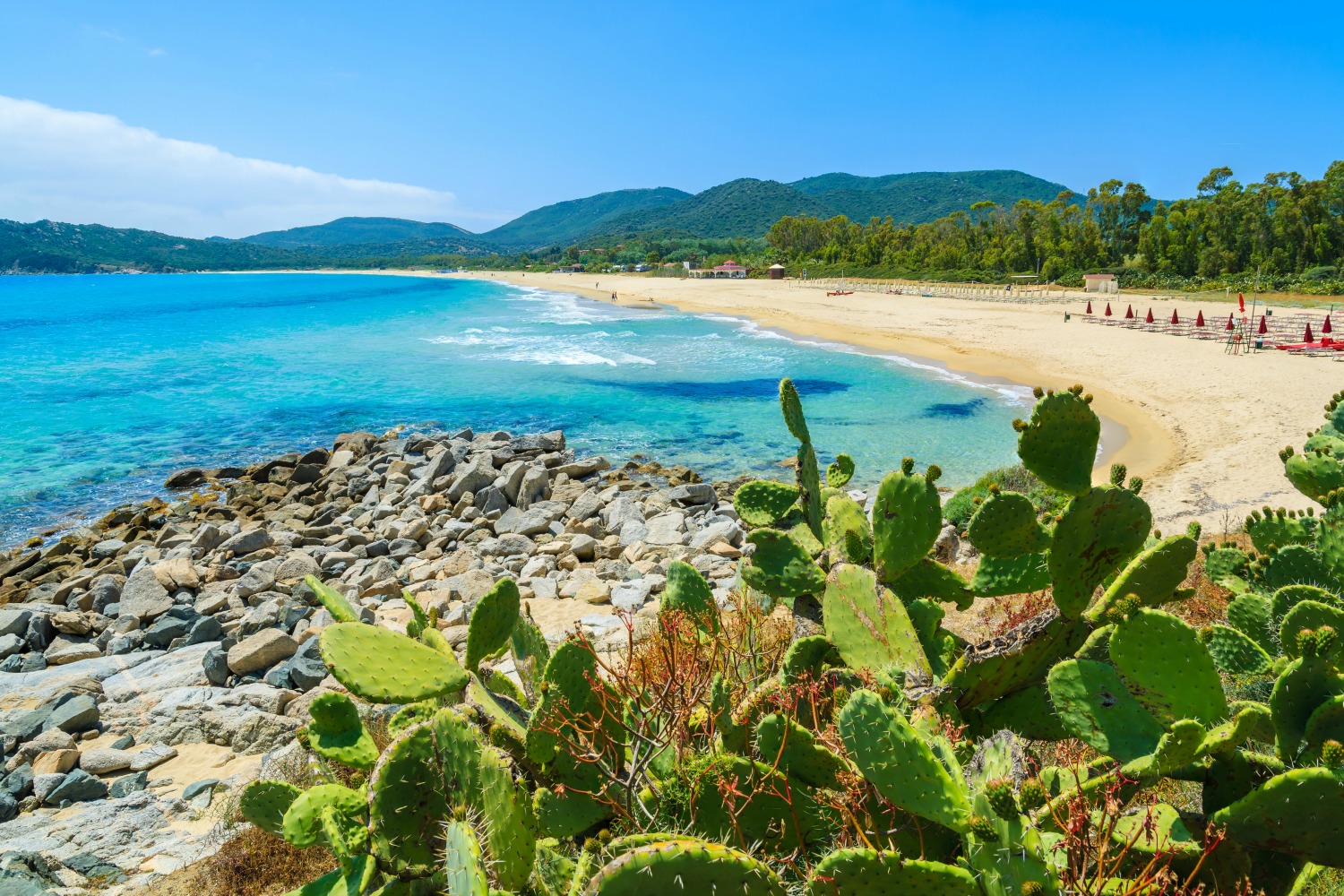
Cala Sinzias
A small cove that opens its beauties beyond a thick eucalypt grove, protected by a promontory that offers a spectacular view of the turquoise horizon. The Cala Sinzias beach, 15 kilometres from Villasimius and 7 from Costa Rei, is part of the territory of Castiadas. The cove is a 2-km strip of fine, soft sand, deep and very white, incredibly clear seabed that drops quickly, and crystalline waters with various blue hues, marked by Goletta Verde of Legambiente as one of the cleanest in Sardinia. The beach is dotted with a few rocks, providing the landscape with a variety typical of the eastern coast. Behind it, thick vegetation: junipers, mastics, olive trees, pine trees and eucalypts.
If you love road trips, Cala Sinzias is perfect for you: a parking space equipped for campers and two famous camping sites right in front of the beach. The very wide beach makes it possible to relax in absolute tranquillity and to walk along the shoreline or swim in the deep water, with all services available: parking, beach equipment for rent, bars and restaurants. The beach is accessible to disabled persons, and its sea is so rich that it is a beloved destination of experienced and amateur scuba divers. Beaten by the wind, it is also a popular surfing destination. All 13 kilometres of the Castiadas coast immersed in green are some of the island’s most beautiful areas, with a succession of white-sanded and bright-coloured landscapes. The southern tip of Cala Sinzias is the Cappuccino rock. There begins a little piece of paradise: the Cala Pira beach, with soft sandy dunes and intense Mediterranean scents. To the north, there is Punta San Pietro, with another wide and marvellous beach. Beyond begins the very long coast of Costa Rei, ten kilometres of fine, golden sand that gradually dive into a sea that is the colour of the sky. The territory of Castiadas includes the beaches of Monte Turno, Sant’Elmo, and Santa Giusta, all the way to the Scoglio di Peppino, coastal boundary with Muravera.
San Giovanni Suergiu
Created out of the progressive joining together of several settlements, it is located on the Sulcis plain, near the lagoons of Porto Botte and Sant'Antioco, where you will observe herons and flamingos. San Giovanni Suergiu is a village with six thousand inhabitants and made up of four main districts (San Giovanni, Palmas, Is Urigus and Matzaccara), as well as a myriad of smaller urban concentrations. Its urban history began in the Byzantine age, in the 9th century, with Villa di Palmas di Sols, a village that developed thanks to the abandonment of the ancient towns of Bithia and Sulci. Still remaining from that flourishing period, you can see the ruins of the Palmas Castle (11th century) and the little church of Santa Maria (12th century), the main place of worship of that period.
In the eighteenth century, around the old Palmas di Sols, various Medaus and Furriadroxius, small villages, were formed, including that of Suergiu, which became a nucleus of the future village, known as Palmas Suergiu (1853). It underwent remarkable expansion and, in the first half of the 20th century, rapid industrial development. The Power Plant of Santa Caterina, now an abandoned site that can be visited, and coal and magnesium refineries were established. In 1952, the Municipality took on its current name: the name of the patron saint was added to the name of one of the medaus, around which it developed. In the old town centre, you will see the Late Romanesque ruins (façade and one wall) of the old church of San Giovanni Battista (14th century), a parish church until 1936. The new parish church of San Giovanni was built in 1959. On the façade you can admire a mosaic by Filippo Figari. The most heartfelt festivity in honour of the saint takes place on 24 June. It is also repeated at the end of August, when you can taste the traditional pastries (piricchittus and pistoccus de crobi).
San Giovanni Suergiu boasts a beautiful stretch of coastline and, in particular, you will be able to enjoy the soft sand and the crystal clear sea at the beaches of Porto Botte and Punta Trettu and the coast of S'Aqua Salida and Sa Terredda. The territory was already inhabited in the Pre-Nuragic period, as is confirmed by the necropolis of Is Loccis Santus, made up of 13 Domus de Janas. There are countless traces of the Nuragic age: Tombs of Giants, sacred wells, three complex Nuraghi and numerous other single-towered ones. The maximum expressions are the Nuraghi of Is Meurras and the impressive complex of Craminalana, with nearby Tombs of Giants (and anti-aircraft posts from the Second World War). The territory continued to be frequented later on: in Sa Guardiedda, on the lagoon between Sulki and Monte Sirai, there is a dock from the Phoenician-Punic period, still visible today.
Carloforte
U pàize is a Ligurian enclave in Sardinia: it preserves the language and culture of its founders, the fisherman families originally from Pegli, and from the Tunisian island of Tabarka (where they lived since the 16th century). The tabarchini in 1738 obtained permission from King Carlo Emanuele III to colonize the island of San Pietro, which was uninhabited and known as belonging to 'the sparrow-hawks' since the Phoenician settlement (8th century BC), followed by the Carthaginians, with temple and necropolis . The same fishermen, 40 years later, also founded Calasetta on the facing island of Sant'Antioco.
Carloforte, still closely linked to Pegli and Genoa, is the only centre of the island, with six thousand inhabitants: it will captivate you with narrow streets and alleys that climb up a slight slope, with colourful sea views, marina and ancient defensive fortifications, of which remain watch towers and stretches of walls with forts, including the Lion's Gate. The architecture of the village, which is in the club of the most beautiful in Italy, we note the early 20th century a Palassiu , today the Giuseppe Cavallera cineteatro (cinema and theatre), and the church of the Madonna del naufrago, which houses the wooden statue revered by the tabarchini, a symbol of faith and solidarity union of the community. The devotion to San Pietro, protector of coral divers and tuna fishermen, solemnly celebrated on 29th June, was also deeply felt. On the seafront stands the monument to Carlo Emanuele III, a marble group of three statues (1786) with the sovereign from which the name of the village derives, while the parish church was dedicated to San Carlo Borromeo. At Spalmadureddu there is the San Vittorio tower, a defensive outpost built with blocks of trachyte, converted in 1898 to an astronomical observatory. Since 2016 it has been used as the multimedia museum of the Sea, which tells the story of Carloforte. After all, the sea is an essential part of it: the coasts of San Pietro are a succession of jagged rocks and inlets. To the north, you will find the romantic Cala Vinagra; to the north-west the deep fjord that is closed by the enchanting Cala Fico; to the west the impressive promontory of Capo Sandalo, dominated by the nineteenth-century lighthouse, and the one that is furthest west in Italy; to the south lies the scenic La Bobba beach, Conca beach with its sheer cliffs, and Le Colonne, two sea stacks sticking up out of the water and the symbol of Carloforte.
Carloforte cuisine is an unmissable experience. Between May and June, an international gastronomic event known as the Girotonno promotes the local specialties with culinary competitions and live cooking shows. Tuna is revisited in imaginative recipes. No less fascinating is the picturesque tabarchino cous cous festival, held on 25th April. From cooking to cinema with Crêuza de mä, a Carloforte event dedicated to film soundtracks.

Archaeological Museum of Villasimius
The history of Villasimius and its territory are inextricably linked to the sea. The stories of clashes and encounters between the different peoples who crossed paths in its waters, often exchanging goods, customs and knowledge, are told in the archaeological museum, located in the rooms of a 19th-century rural ‘courtyard’ house. A staircase with terracotta tiles, leading to the upper floor, and a wall made of ladiri (raw earth bricks) are what remains of the ancient manor house. The exhibition contains artefacts that date back to a period of time ranging from the Nuragic age to the Spanish domination in the Middle Ages. Many were recovered from the seabed, from wreckages and during underwater excavations. The museum is spread over two floors and four rooms, along an itinerary based on both a chronological and a thematic criterion.
The first room is called ‘of the sea’. Trade, routes and shipwrecks are the common thread of the exhibition, in which, in particular, you will see Punic amphorae from the 5th century BC. They probably came from the Balearic Islands and were found in front of Isola dei Cavoli. The second room focuses on the artefacts from the sanctuary of is Cuccureddus, perhaps dedicated to the goddess Astarte. You can admire the reconstruction of its external appearance, as well as numerous objects of daily use dedicated to care of the body and food preparation. The votive offerings and bronze coins provide evidence of the Roman era. You can continue the visit in the territory room: the room contains the cargo from the ‘relitto del canale’ (shipwreck of the canal), a Roman ship from the 1st century AD that transported building materials and sank in the canal of the Isola dei Cavoli. In this room, you can also admire materials from the Santa Maria area, where a thermal baths building was installed, later used as a necropolis in the early Middle Ages, and from the Roman necropolises of Cruccuris and Accu is Traias. There is a marble statue that comes from the thermal area, depicting a woman, associated with the Virgin Mary in centuries past and used as an object of worship in the nearby church.
The last room is entirely dedicated to the Spanish wreckage of the Isola dei Cavoli, of a ship that probably sank due to a storm in the 15th century while sailing towards Sicily. You will be surprised by the weapons, particularly the cannons, and the azulejos, unusual cladding tiles with a blue and gold enamel coating. In the Villasimius area, there is other evidence of the Aragonese Crown: the most obvious is the Fortezza Vecchia, a defence tower perhaps dating back to the 14th century and built on a rocky promontory south of the village. Today, a permanent exhibition on piracy is held there and it ‘guards’ the eastern extremity of the Golfo degli Angeli (Gulf of Angels) and the Marine Protected Area of Capo Carbonara. On the subject of the sea, around the cape you will find the picture-postcard coastlines of Simius, Porto Giunco, Cala Caterina, Santo Stefano and the Spiaggia del Riso, next to the tourist port.
Piscina Rei
This is one of the large beaches that make up the splendid Costa Rei coastline, defined by the prestigious Lonely Planet guide as one of the top ten beaches in the world. You can reach Piscina Rei, in the territory of Muravera, from one of several access points, along a coastline bordered by junipers, Mediterranean bushes and bright white sea daffodils. The brightness and softness of the sand, the crystal clear, shallow water, together with a few smooth rocks make you feel like you are bathing in a natural swimming pool.
This is the ideal beach for families with children, the middle aged or elderly looking for relaxation, couples and singles, and is popular with underwater fishing, diving and snorkelling enthusiasts. Bars and beach equipment rental points are available. The nearby tourist town of Costa Rei offers every service and convenience.
Piscina Rei is part of the coast to the south of Muravera that extends for dozens of kilometres. From the beach of San Giovanni with its quartz sand to Torre Salinas and Colostrai, an oasis with dunes covered in sea daffodils, to Feraxi with over two kilometres of fine bronze-coloured sand. Then come the more protected coves of Portu de s’Illixi, CalasaFigu and the Baia delle Anfore (named for the Roman shipwreck), before the granite rock of Capo Ferrato with its lighthouse, and Monti Ferru, a suggestive panoramic viewpoint that can be reached on foot or by mountain bike. The 'pure white' beach of Iba de ziuFranciscu leads to Costa Rei, the longest low and sandy stretch of coastline along the eastern coast: nearly eight kilometres that stretch as far as the Scoglio di Peppino and another two in the territory of Castiadas.
Not just beaches: in the surroundings, don't miss the flamingos in the Muraveralagunas and archaeological sites: in Piscina Rei, you'll find the Cuili Piras megalithic complex, near the Nuraghe Scalas standing stones, arranged in lines according to the stars and the heavens, and the Punic Fortezza di Baccu in the overlooking locality of Nai.