

Santa Maria - Uta
A ‘mixture’ of techniques and styles, resulting from the use of workers from different places, a sudden ‘transformation’, a legend and some doubts about its origins make it one of the most valued and intriguing examples of Romanesque style in southern Sardinia. Santa Maria stands in the outskirts of Uta, a village with an agricultural vocation twenty kilometres from Cagliari. There are two theories about its construction: according to the first, the building dates back to the first half of the 12th century, the work of the Victorine monks of Marseille, who are thought to have created the last and most complete example of a Romanesque sanctuary of almost thirty attributed to them. The second theory ‘moves’ the building forward by a century - constructed on the ruins of a previous two-nave church built by the monks -, due to its affinity with the former cathedral of Santa Maria di Monserrato in Tratalias and particular symbols ‘spread’ around inside it.
The first documentary mention dates back to the second half of the 14th century and testifies to the transfer of ownership from the Knights Hospitaller of Saint John of Jerusalem to the Knights of Saint George of Alfama. In reality, the sanctuary was guarded by the Franciscans until the 17th century. The monastery’s rooms probably extended to the back of the church, in a fenced area later used as a cemetery. In the centre there is a well, which must have been ‘the heart’ of the cloister that has now disappeared. Popular belief attributes miraculous properties to the water in the well: miracles and healings are said to have occurred, so much so that, on the occasion of the September festival, numerous infirm people would go there on a pilgrimage.
The church was built with limestone, perhaps from the Teulada, quarries, with a basilica layout, three naves - originally two, and then extended to the south -, and a semicircular apse. The work of various builders, French, Arab and Tuscan, can be seen on the façade: the northern side and the left side of the façade are the result of French workmanship; the Tuscan school stands out in the lunette door, on the southern side and in the apse; the frieze separating the two orders of the façade is Arabian style. Each side has an opening: on the right the Holy Door, in the past opened exclusively during jubilees; on the left, the ancient access to the cloister. Inside, you will notice two Roman capitals, the first in the third column on the left and the second used as a holy water font. Looking at the apse from the outside, you will see two symbols: a patriarchal cross and an eight-pointed cross, probably the Maltese Cross. In an ashlar to the left of the south entrance, however, there is a cross pattée “a fiammata”, difficult to interpret: according to some, it cannot be ruled out that the Knights Templar also moved around Santa Maria or the surrounding area.
It’s a small leap from art to nature and, in fact, it is only a few kilometres from Uta to Monte Arcosu, where you’ll find the WWF Natural Oasis, and to the Park of Gutturu Mannu.

Cemetery of Bonaria
A sumptuous and ghostly art gallery outdoors. The streets of chapels and headstones in the cemetery occupy the Bonaria hill with funerary architecture and sculptures, works by the most popular artists who were active in Cagliari from half 19th century to the early 20th century. They reflect the taste of noble and high bourgeois families of the time, who rivalled against each other in their displays of wealth and power through funeral monuments.
Up until Napoleon’s decree that forbid burials in sacred places and in the centre of the city, in Cagliari the dead were buried in or near churches, with tragic consequences, including an epidemic of cholera in 1816. The cemetery was made at the foot of the hill, then in the periphery of the town, and had already been used as burial site during the Punic-Roman and paleo Christian eras.
It was built by Napoleon and consecrated in 1828. Various enlargements took it all the way to the top of the hill. It lost its function in 1968, and since then it has crystallised: no more suffering, but serenity, families without descendants, and oblivion.
Cypresses, hibiscus, palms, pine trees and roses embrace statues and chapels, made in various and harmonised styles: baroque, Art Nouveau, neoclassic, symbolistic, ancient and military signs, as in Viale degli Eroi, for those who died in the wars. Medallions, torches, stems, obelisks, sculptures of all kinds, bas- and alt-relief decorate the tombs. Epigraphs and inscriptions complete them.
You will feel the call of the souls as you walk along the boulevards. Uphill lie the young ones: sisters holding each other in an embrace and little brothers taken away by an angel, little Efisino sitting on his epitaph, Mary leaning on a balustrade as she peeks at the visitors. Pride and tragedies: Amina, the youngest of two sisters, died at 17 (1884) as a celebrity: the first Sardinian woman to obtain a middle school diploma in a public school. At a time when only boys were encouraged to study, it was quite an accomplished, but her sister Jenny also studied, but committed suicide two years later. Higher up, ossuaries and burial recesses. Many works were signed by the so-called Michelangelo of the dead, Giuseppe Sartorio. For instance, the sculpture of attorney Todde: in the foreground is his wife, with a scarf falling over her dress, masterfully sculpted. During her 25 years as a widow, Luigia saw herself smugly in that sculpture. At the top, noble and bourgeois memories were intertwined: merchants, entrepreneurs, artists and intellectuals who put a sheen on Cagliari. Not far from the cemetery lie two basilicas worth visiting: Sardinia’s Christian temple par excellence, Nostra Signora di Bonaria, and the island’s oldest paleo Christian sanctuary, the basilica of San Saturnino, the patron saint of the city.

Ingurtosu
Its name comes from gurturgiu, a species of vulture, or from 'inghiottitoio' (ponor), perhaps relative to ancient excavations. In both cases, it fully defines the wild setting in which it is located. Set between rugged mountains, Ingurtosu, a district of Arbus, which is ten kilometres away, is located in the valley of Is Animas, which stretches as fare as the sand dunes of Piscinas, a gem of the Costa Verde, where wagons used for transporting extracted material are abandoned. For over a century, it was the business centre of two mines, that of the same name and Gennamari, which were part of the Montevecchio complex. Today it is a deserted village in ruins.
The mining settlement extends along the entire valley, where there is an evocative atmosphere. You will move through timeless landscapes: the ruins of houses, plants and wells, enormous heaps of waste materials and rusted carts. A village out of the far west, now almost fossilized. Along the valley, you will find the remains of construction yards, washeries and seven villages, with a total of 900 total spaces that accommodated up to 2,500 labourers and their families. The humble miners' dwellings with the imposing granite management building, known as the 'castle', built (1870) in Neo-medieval style and characterized by an elegant balcony closed-in by glass panes. Its position was dominant. Alongside them, you will see an outlet and shops, post-office and newsagents, infant school and hospital, other services and even the cemetery. Then, there is the little church of Santa Barbara, patron saint of miners, dated 1916. Along the road from Arbus to Ingurtosu, you can admire Villa Wright and Villa Ginestra, respectively the dwellings of the deputy director and the president of Pertusola, an English extraction company that managed the mines.
Thanks to the highly advanced machinery, between 1855 and 1968, silver, lead and zinc were extracted from the numerous deposits. The apex of productivity was the period between the 19th and 20th centuries, following the transition to the English company: it meant development and innovation, which was the merit of Lord Thomas Brassey. The decline arrived after the Second World War, when the mining industry collapsed. Despite the concessions in 1964 transitioning to the Monteponi-Montevecchio company, the plants closed for good a few years later. The buildings became ruins and Ingurtosu a ghost town.

Girin
A tropical landscape suitable for children. The beach of Girin, on the southeastern coast of the island of San Pietro – the second largest of the Sulcis archipelago - is characterised by the nature in which it is located and by its natural ‘predisposition’ for welcoming families with children, so much so that it received the Green Flag, an award assigned by Italian paediatricians to beaches with characteristics based on safety and leisure. The beach is just under 150 metres long and extends into a bay bordered by two low promontories. The beach has soft, light sand mixed with shells and a crystal-clear sea reflecting shades of turquoise, blue and emerald green, surrounded by fragrant Mediterranean scrub.
On clear days, you can see the coast of Calasetta on the island of Sant’Antioco on the horizon, the largest of the Sulcis archipelago. The water is shallow with a gently sloping seabed and its position, facing south-east, shelters Girin from the northwesterly ‘maestrale’ wind, making it pleasant and safe for children to bathe and play. The beach is divided into two parts by a group of rocky outcrops and flat rocks where you can stretch out, while the basalt cliffs on the sides have an attractive bright red colour.
Just over three kilometres separate the beach of Girin from the port of Carloforte, the only inhabited area on the island. To reach it, you can take provincial road SP 103 southwards until you come across a diversion to the left, marked with a stone displaying the name of the beach: here you will find a large parking area. Along the scenic road, you will come across several diversions that lead to the longer beach of San Pietro and that closest to the village, the beach of Giunco, surrounded by rushes, where the transparent waters are shallow, crystal clear, blue near the water’s edge and deep blue where the depths are greater. A stretch of the beach is reserved for our four-legged friends and is the only dog beach in the Carloforte area.
Continuing further south, you will find three beaches in succession: Punta Nera, divided by a stone barrier and next to a cave; Guidi, which will captivate you with the contrast between the white sand and the dark tuff rocks; and La Bobba, featuring a turquoise sea and a path that leads to the Colonne, the island's symbolic sea stacks. Rugged, rocky cliffs dominate the other sides: to the south, peregrine falcons and Audouin’s gulls circle between the crags of La Conca. To the east, you will see the stunning picture postcard colours of La Caletta and the fjord where Cala Fico opens up and where the Eleonora’s falcon lives. In another fjord, on the northern coast, lies Cala Vinagra, where an islet of pink rocks stands out against the emerald green sea.
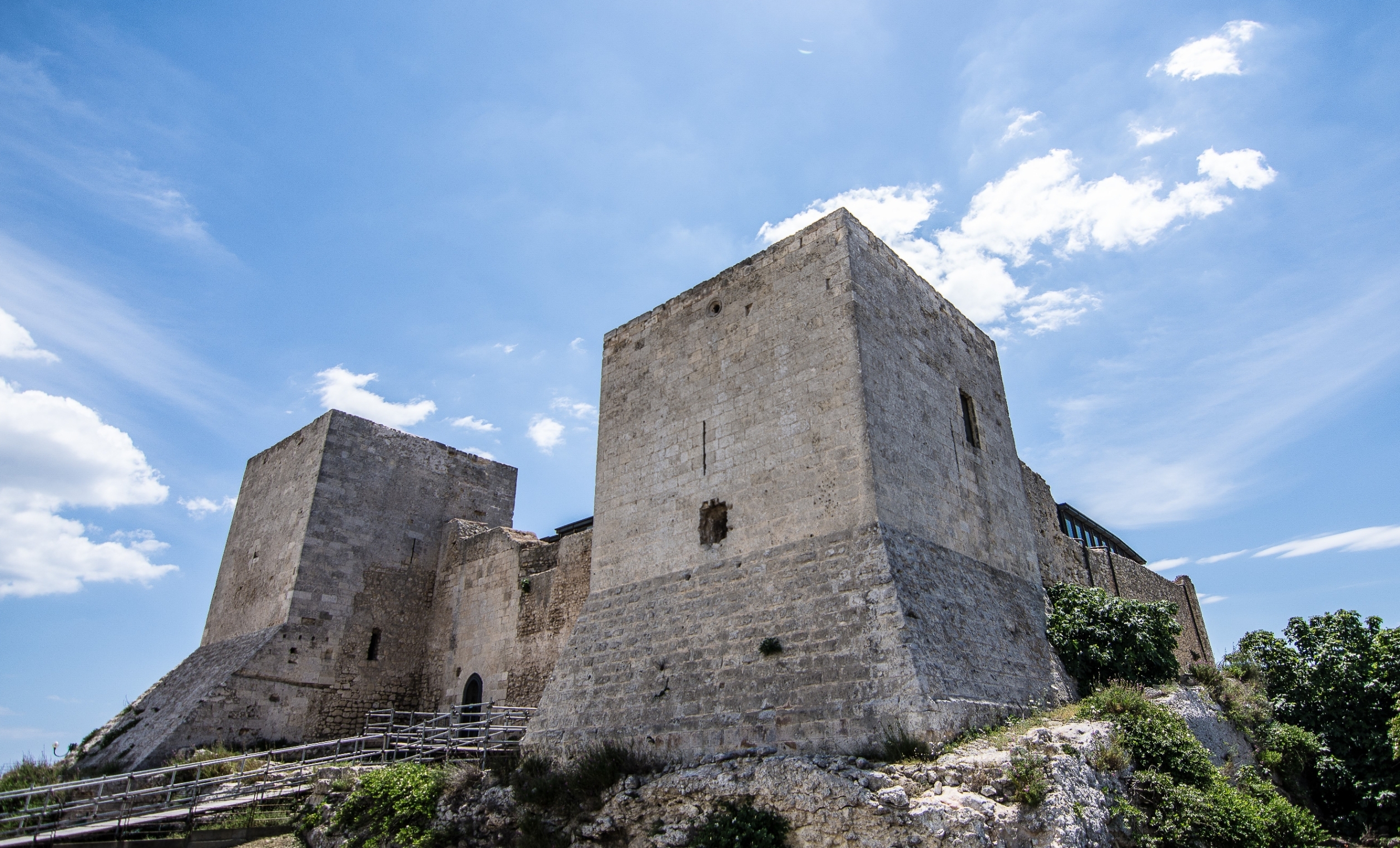
Castello di San Michele
Cagliari is built on seven hills and it is thought that the Romans worshipped the god Aesculapius atop the Colle di San Michele. In the Byzantine era, the pagan worship for the protector of medicine was replaced by the Christian worship for San Michele. Perhaps it is no coincidence that on the top of the hill, which can be reached from hairpin bends rising up between white tuffaceous rocks and the green of agaves and Mediterranean greenery, it appears there was once a monastery and, later, a church dedicated to the archangel. Rising up today, in excellent condition, is a medieval castle that overlooks the city, surrounded by a green park. Once isolated, today it is part of the is Mirrionis district. A 360-degree view of the capital can be enjoyed from the top, with the Pisan towers of the Castello district, the port, the Poetto, the Sella del Diavolo and the Santa Gilla lagoon. The manor, having long been the sentinel of the access road from Campidano, can be seen from all points around the town and the surrounds, even from kilometres away.
The quadrangular structure of the castle, built of limestone from the Cave of Bonaria, has three large corner towers, two older, to the north-east and south-east, constructed with perfectly squared ashlars, and a south-west tower that was erected later with a coarser technique, rising up even higher and without a talus wall base like the first two. They are connected by curtain walls. In the west, traces of the Romanesque façade of the Oratorio di San Michele Arcangelo can be seen. It has two entrances side-by-side, an indication of a building with two naves that became the castle’s chapel, after having been incorporated therein. Around it is a wide and deep moat that can be crossed by a bridge, today as in the past, perhaps as early as the Piedmontese operations undertaken in the 18th century, which transformed the ancient manor into a modern fort.
The origins are controversial. One evocative theory places the birth between the end of the Byzantine age and the beginning of the time of the Judicatures (10th century) - a single tower to defend what was then the capital, Santa Igia. The structure would then be completed under the Pisans. More likely, the foundation is from the 12th century (from the Giudicati or Pisans), then reinforced in the 13th century with the addition of the two eastern towers. The third tower and other additions would then be Aragonese, starting in 1325, when Berengario Carroz, longa manus of the emperor Alfonso, received the San Michele hill in fief. In a few years, he transformed it into a fortress and a luxurious residence, adorned with precious objects (perhaps) plundered from the Basilica di San Saturno. Throughout the 14th century, the Castello di Bonvehì - so renamed at the time for its splendid view - benefited greatly from the various sovereigns. The Cagliari authorities contested the operations and abuse of the privileges granted by the Crown. The issue was resolved upon the granting of extradition to those who had enjoyed the protectorate of the Carroz. The events of Bonvehì remained inextricably linked to the noble Spanish family of the Carroz until 1511, following a century and a half of splendour. The last member of the family to live as the lord of the castle was Countess Violante, greatly feared and cursed by the clergy for the murder of a priest. During her time, the castle was also referred to as ‘della Contessa’ (the ‘Countess’s castle’). Apparently, her ghost still wanders about the fortress. In addition to ghosts, there are also various underground tunnels and treasures - there is evidence of an accusatory procedure (18th century) against a priest found guilty of having sought a treasure hidden in the castle through the ritual of ‘afromanzia’ or ‘idromanzia’ (hydromancy), being the invocation of the devil and recitation of magical spells. After the Carroz era, the castle was abandoned for over a century, before being used as a lazaret during the ‘Plague of Sant’Efisio’ (1652-56). Military functions resumed at the end of the 18th century, with the last moment of glory being in 1793 when, equipped with cannons, it defended the city from the invasion of Napoleon’s militia. In 1867, it was sold to the Marquis Roberti di San Tommaso, who had it restored by Dionigi Scano and began the reforestation of the hill with Aleppo pines. From 1929 to 1972, it was the Navy’s radio-telegraphic station. The restoration and enhancement works of the late-20th century transformed the fortress into a modern art and culture centre, with the hill becoming a site of scenic value.

Maracalagonis
Surrounded by gentle hills, Maracalagonis has eight thousand inhabitants and is located in the southeastern part of the Campidano area, 15 kilometres from the Island's capital city. It is renowned for its homemade pastries, basket weaving and Sardinian brocade costumes. Its territory, framed by the mountains of Punta Serpeddì and the Oasis of Sette Fratelli (Seven Brothers), extends as far as the coastal tourist localities of Geremeas and Torre delle Stelle. A land inhabited since prehistoric times (3rd millennium BC), as is evident in the Eneolithic necropolis of Cuccuru Craboni, the Pre-Nuragic village of Cann'e Sisa and the remains of various Nuraghi, later frequented by Phoenician and Punic populations. As well as the ruins of a Punic temple, two sandstone statues of the god Bes were found and are kept at the National Archaeological Museum in Cagliari. In the current village area, various other little villages emerged in the Middle Ages, among which Mara and Calagonis, which belonged to the Giudicato of Calari. From 1416, in the Aragonese age, the union of these two localities gave rise to the municipality of Mara de Calagonis.
Today, Maracalagonis boasts a series of charming beaches in the eastern part of the Golfo degli Angeli, along the scenic road from Cagliari to Villasimius. Havens of light sand and blue sea, surrounded by green hills, 25 kilometres from the residential area. In the locality of Geremeas, shared with Quartu Sant'Elena, the territory of which includes the sandy shores of Kala 'e Moru and Marongiu, there is the beach of Baccu Mandara with its soft golden sand, washed by a green and turquoise sea. Continuing on along the coast, you will come across another famous locality in the Maracalagonis area: Torre delle Stelle, where there are the two breathtaking beaches of Cann'e Sisa and Genn'e Mari, separated by a promontory dotted with villas and tourist facilities, becoming a true village in the summer.
The patron saint of Mara is Santo Stefano (St Stephen), who was born in 82 AD, under the Roman emperor Trajan, and who died a martyr, when he was pierced in the head by a nail. His remains are preserved in the parish church consecrated to him in 1925: his skull with the nail is kept in a shrine and the other bones are inside his simulacrum under the main altar. In the centre of the village, the church of the Vergine degli Angeli is worth visiting. Its style is Romanesque and it was consecrated in 1237 and remodelled in the centuries that followed. Around the village, there are the rural churches of San Basilio and San Gregorio.
Mandas
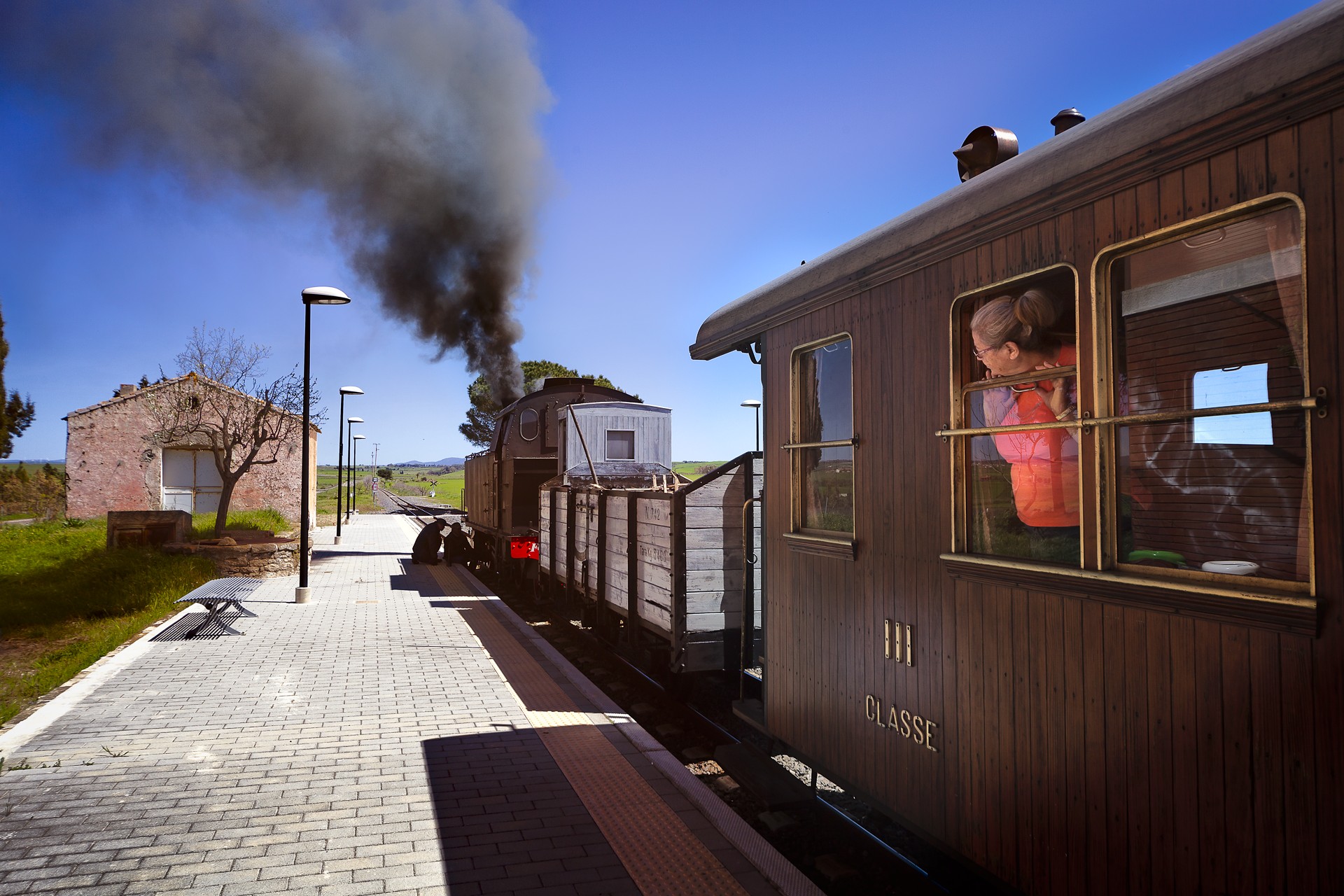
“I could hardly believe my eyes, it was so like England, like Cornwall in the bleak parts, or Derbyshire uplands”. These are the impressions that David Herbert Lawrence described in Sea and Sardinia upon his arrival in Mandas (1921): “a shunting railway station - says the English writer - where these little trains stop, for a long and pleasant chat, after an arduous climb up the hills”. Today an agricultural and pastoral municipality with over two thousand inhabitants on the border between Campidano and Barbagia, the village was a narrow-gauge railway hub for a long time, which took you from Cagliari to the Mandrolisai and Ogliastra areas and is now a Trenino Verde tourist line: you will travel along panoramic tracks following in the footsteps of Lawrence, through cultivated hills, gorges, rock faces and the northeastern shore of Lake Mulargia.
Not to be missed is the park of Acqua Bona with its medieval spring. To reach the centre of island, you need to pass through this fertile territory, which was intensely inhabited during the Nuragic age and there are about 50 sites bearing witness to this, among which the Tomb of Giants of S'Arruina de Su Procu and the complex of Su Angiu, where a little bronze incense-boat was found and is now on display at the National Archaeological Museum of Cagliari. The splendour of Mandas dates back to the Spanish domination: in 1614 King Philip III raised the village to a dukedom, a title - the only one granted by the Crown on the Island - that it kept until 1838. There are still traces of a glorious past in the town: various noble and middle-class palaces. “Let us continue on through sandstone and granite”, Lawrence suggests: and the majestic nineteenth-century municipal building appears, as well as the medieval complex consisting of a little church (thirteenth century) and the convent of Sant'Antonio Abate, which overlook a Roman road (the Kalaris-Ulbiastretch), a tangible sign of the passage of the Romans. The ethnographic museum of Is Lollasa 'e Is Aiaiusu (the rooms of the grandparents) is nearby and is an eighteenth-century dwelling and historical memory of Mandas. Also worth visiting are the seventeenth-century complex of San Cristoforo and San Francesco and the church of Santa Vitalia. The most important religious building is in the outskirts: inside the parish church of San Giacomo, built between 1585 and 1605 in Gothic-Catalan style, there are works by Spanish and local engravers: a set of wooden works with a Crucifix, Virgin Mary and St John, seventeenth-century multi-coloured statues and various eighteenth-century wooden altars. The 'marbles' date back to the second part of the 18th century: main altar and baptismal font. At the exit, there is Sa Perda de Sa Bregungia, an ancient medieval pillory. Along with the celebrations of the patron saint at the end of July, there is the Cheese Festival, a chance to taste the local delicacies.

Nurallao
Sheltered by two limestone hills, it sits next to SS 128, separating Campidano from the island’s interior. Nurallao is a town of 1400 inhabitants in Sarcidano, a border area between the provinces of south Sardinia and of Nuoro, with strong agro-pastoral activity and craftworks: it is famous for producing lime, shingles and pots. Deposits of refractory and china clays near the town were the source of considerable income in the first half of the 20th century. Past mining activity, which is now in decline, is attested by the abandoned mines of Niachili and by various kilns, including Funtan’e Susu, an industrial archaeology site. Until the 1960s, the mines were serviced by mining rail lines. Today they are part of the Trenino Verde line, which connects Isili with Sorgono passing next to Lake San Sebastiano. The lake is fed by Sarcidano river, which flows by common and holm oaks and Mediterranean shrubs of the Funtana is Arinus Park and forms the Su Craddaxioleddu Waterfall. This natural oasis, just north of the town, hosts the Festival of Is Tallarinus Nuraddesusu, typical dish of Nurallao, on Easter Monday, and a Sheep Festival paired with the Procession of Sant’Isidoro of is traccas (floats) in May. The most highly-anticipated event, the Regional Music Festival, takes place in September. At the end of June, the Feast Day of the patron saint, Saint Peter the Apostle, is celebrated with a procession in traditional dress that sets off from the parish church, where a 17th century statue of the patron saint is housed. The Church of Madonna della Strada is a must see. Set in the woods, it is the final stop of a mid-August pilgrimage undertaken for the Driver’s Festival.
Nuradao is mentioned in the peace treaty between Eleanor of Arborea and John I of Aragon (1388). The place name may derive from the Nuragic-Etruscan word for mound or walls. The Punics built fortifications around the town, which was then occupied by the Romans, who left traces at Sa Bidda Becia. Here, one can see the remains of houses, roads and wells of a village and the Baths of Cannedu (I-III AD). In Nieddiu, in the vicinity of which a fascinating Well Temple can be found, stands one of the area’s nine nuraghes. At Sa Conca ‘e Sa Figu, bronze statuettes of Sardus-Pater and a goddess were uncovered, in addition to a considerable amount of tin and lead, as well as a building, possibly a bronze foundry. Most importantly, in Nurallao, there is one of the biggest megalithic tombs in all of the Mediterranean: the Giant’s Tomb of Aiodda. Located in Pranu is Ciaexius, on the border with Nuragus, it is shaped like a taurine protome with an exedra of orthostatic slabs and an arched stele, at the base of which, a small door leads to 10-metre long burial chamber. Pottery fragments, copper and bronze pins, and fragments of steles with sculpted symbolic patterns similar to those found on menhir statues of Sarcidano (i.e. upside down human figures with and without daggers), were found. The burial dates back to 15th century BC, however it was in use even before, as seen from the “recycled” menhirs dating to 3000-2500 BC.
Capo Boi
In the easternmost part of the Golfo degli Angeli (Gulf of Angels), a rocky promontory covered with dense Mediterranean greenery extends towards the sea: on its right lies an immense expanse of golden sand, while on the left there are a series of coves with very white sand nestled in the cliff. Overlooking the promontory, called Capo Boi, 120 metres above sea level, stands an ancient watchtower, which has dominated this spectacular panorama for almost five centuries. The cape represents the western limit of the marine protected area of Capo Carbonara, as well as the coastal border between Campidano and Sarrabus, and it falls within the coastal enclave of the Municipality of Sinnai.
The construction of the tower, commissioned by the Spanish Crown, falls within the scope of the Royal Administration of the Towers, an institution created to defend the island’s coasts from Saracen incursions. It was built during the last decades of the 16th century from granite and mortar and is just under ten metres high. It was a torrezilla, or a tower with sighting functions only, where two soldiers and just a few weapons were placed. It has a truncated cone shape and the entrance is located about four metres above ground: the guards entered via a ladder, which was then pulled inside. At the foot of the tower, a splendid horizon opens up before your eyes: to the east you’ll see Capo Carbonara and Isola dei Cavoli, while on the right you can look down onto the large golden sandy shore that characterises Solanas, a splendid beach extending for over a kilometre from Capo Boi to Punta Pedrosu and washed by a sea with waters varying from blue to emerald green. On the left, on the slopes of the promontory, you will notice a sand dune next to the mouth of a torrent. On the eastern side of the rocky spur of Capo Boi, a series of hidden coves and cliffs can be reached by sea in private boats or on excursions from the port of Villasimius. You will be able to explore small, isolated and uncontaminated beaches, surrounded by Mediterranean scrub, around which there are also ravines and submerged caves, ideal for diving enthusiasts. Continuing further east, you will enter the territory of Villasimius: the first beach you’ll come across is Porto Sa Ruxi, with an unusual ‘three-arched’ shape. Its white sand is protected by dunes covered in myrtle and juniper bushes and surrounded by rocky walls, while the sea is a vivid turquoise colour, with crystal clear, shallow waters and a sandy seabed. Porto sa Ruxi is also sheltered from the mistral winds, and will captivate you with its wild appearance and almost tropical stretches.

Is Cannoneris
Human intervention, with indiscriminate cutting, intensive grazing and fires, has risked compromising the balance, but after being taken away from private owners in 1903 and managed by state government, which started its recovery, it is now among the most florid natural sites in southern Sardinia. Is Cannoneris, a hikers' paradise and a place of mysterious tales of reality mixed with fantasy, extends for approximately 4800 hectares in the territory of Domus de Maria, Pula, Teulada and Villa San Pietro. Its surface area is doubled when including the forest of Pixinamanna, to which it is connected. It is also on the border of Gutturu Mannu, the oasis of Pantaleo and mount Nieddu, green areas that are part of the proposal to create a Sulcis nature park.
The green expanse disappears into the horizon: forests of holm oaks, Mediterranean scrub and conifers, the vegetation is very lush everywhere you look. You can move through it via a main road and sign-posted trekking trails. The forest is a protected wildlife oasis: after becoming state property again, it was repopulated with Corsican red deer and fallow deer that inhabit the area, along with wild boar, weasels, dormice and foxes. When you look up you might be surprised to see the flight of the golden eagle, the common raven, the peregrine falcon and the kestrel.
The maximum height is 979 metres, at the top of Punta Sebera, which dominates a large part of the gulf of Cagliari and the southwestern coast as far as Portoscuso, as well as the surrounding forests. The attractive nature and landscape is endless: evocative rock formations can be found in the central-northern part, particularly the sheer rock faces of Calamixi, a wild and legendary place, set between centuries-old trees and steep cliffs, populated - according to popular belief - by bandits, witches and hidden treasure. In Is Concas de S'Arrideli, on the border of Mount Nieddu, huge Mount Etna Broom plants flower. The abundance of bodies of water crossing the forest will strike you: Mitza su Filisargiu, the Isca de Crapitta rivulet, Sa Truba and Sa Para, Su Pizianti and the canals of Medau Angiu and Su Marigosu. The whole territory is enhanced by evidence of Pre-Nuragic and Nuragic civilizations: the necropolis of Montessu, the Tomb of the Giants of Barrancu Mannu and the holy well of Val Tattino.