

Maladroxia
A natural paradise, suitable for families, couples or a relaxing solo break. The beautiful beach of Maladroxia is one of the jewels of Sant’Antioco, about nine kilometres from the centre of the main town on the island. It is characterised by a long and undulating sandy beach of about 500 meters of soft, fine and soft sand mixed with sections of pebbles, plunging into the limpid and crystalline water of a sea with colours ranging from emerald green to turquoise. The seabed is low near the shoreline and gently sloping; just a little further out, you will come across dry dunes of posidonia, on which you can walk. The frequent winds make it an ideal destination for surfers and it is loved by scuba-diving enthusiasts. The beach is surrounded by Mediterranean greenery, and backed by the small village of Maladroxia, a tourist resort with private villas, holiday homes and hotels, restaurants and pizzerias, kiosks and bars. The wide range of services complete the picture: ample parking, buses, and rental services for bathing equipment, pedal boats, canoes and rafts. The village is dominated by a hill surmounted by the s'Ega de Marteddu nuraghe.
Maladroxia stretches in front of the Golfo di Palmas, on the south-eastern side of the Island of Sant’Antioco, the largest minor island of Sardinia, whose territory is divided between the towns of Calasetta and Sant'Antioco. The coastline has high jagged cliffs to the south and lower shores to the north. Portixeddu is the nearest beach to the village, and is made of pebbles, like the nearby and larger Turri beach. Another sandy stretch in the territory of Sant'Antioco is the long and sinuous beach of Coacuaddus, divided into two parts by a large rock and bordered by limestone cliffs. Do not miss the cliffs of is Praneddas (or arco 'dei Baci'), where you can stand on a terrace, 200 meters above the sea, to admire the whitewashed rocks of Cala Sapone and Cala Grotta and Cala della Signora . Capo Sperone is the extreme southern tip, in front of which rise the islets of Vacca and Toro, natural havens inhabited by rare birds.
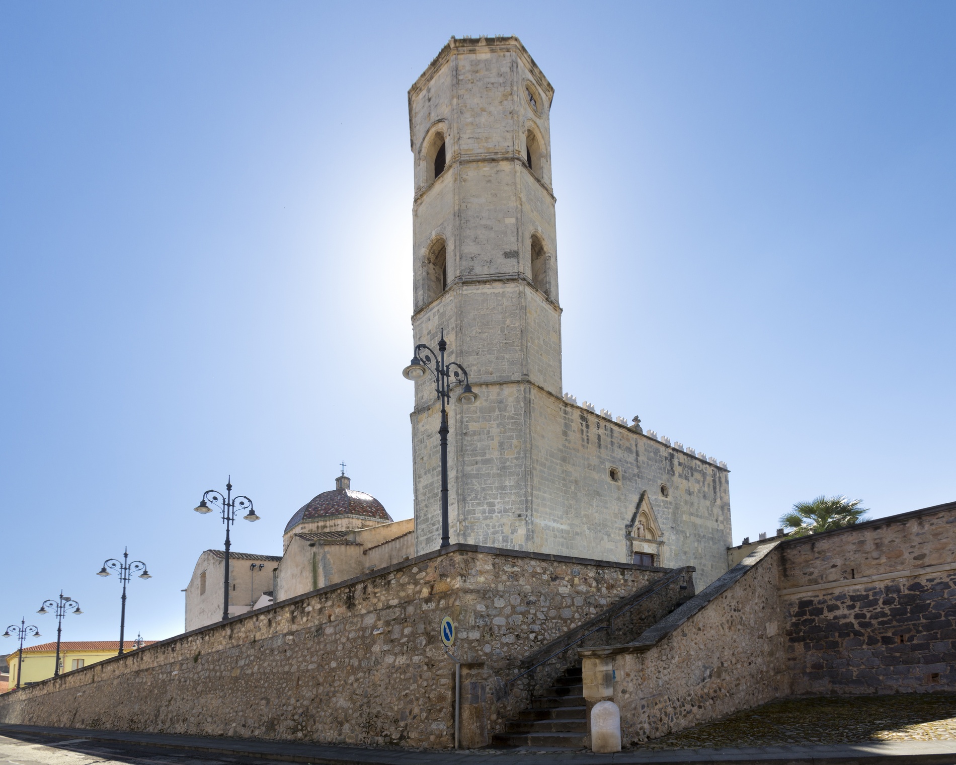
The town is characterised by colourful houses, amazing restaurants and a tourist port, which give it a strong seafaring identity. Once it was known as Sulky, a Phoenician colony born in 770 BC, which later passed under the Carthaginian rule and became a flourishing Roman city with the name of Sulci. Don't miss a visit to the sanctuary of Sant'Antioco Martire, patron saint of Sardinia, and to the Ferruccio Barreca archaeological museum which contains Phoenician-Punic finds.
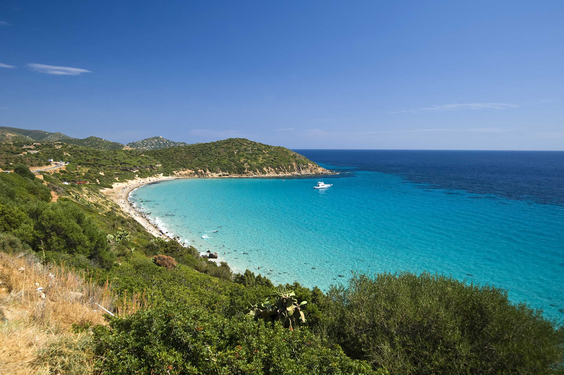
Mari Pintau
It means 'painted sea'. The signature on this painting is nature itself, creator of a masterpiece with skilful artistic brushstrokes and a thousand shades of emerald-blue that contrast with the green of the surrounding hills. Its name could not have been more apt. The wonderful beach of Mari Pintau is the pearl of the territory of Quartu Sant'Elena: it is located along the bends of the scenic road that leads to Villasimius, about twenty kilometres from the centre of Cagliari, in the tourist location of Geremeas.
It is a beach of smooth, round granite pebbles and stones, washed by the crystal clear waters, that become more sparse as they make way for the fine, white sand. Its transparency allows a clear view of the sandy seabed, dotted by rocks on which the sunlight is reflected. Behind the beach, the hills are covered by fragrant Mediterranean shrubs, where there is a path, taking you from the car park to the beach. Mari Pintau is the ideal destination for those who like to do underwater fishing or who wish to dive down to the wonderful depths. You will find services here, as well as a beach establishment with equipment rentals and a kiosk-bar.
Along the scenic road to Villasimius, you can admire other gems: as you reach Cagliari, first you will encounter the splendid rocks of Cala Regina and the pebbles of Is Canaleddus, a beach behind which there is a thicket of eucalyptuses and junipers. As well as the ‘painted sea’, you will find the large bay of Geremeas, featuring beaches of coarse-grained white sand: a promontory separates Mari Pintau from the tiny golden-grained sand of Kala ‘e Moru and then there are the beautiful and relaxing beaches of Marongiu and Baccu Mandara. In the nearby hinterland, you can visit interesting archaeological sites and the mountain park of Sette Fratelli.
Su Suergiu mine
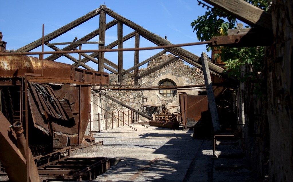
Operating between 1880 and 1987, the year when operations were finally discontinued, it was the most important site for the extraction and processing of antimony in Italy. During the world wars, its foundry produced 90 percent of the Italy’s total. Today, the Su Suergiu mine is a precious piece of industrial archaeology within Sardinia’s geominerary park. The name derives from the cork oaks (suergiu) that contribute to the luxuriant nature of the Sessini valley’s stream, immersed in the harsh rocky context of Gerrei, where mining villages and extraction plants reside. The stream flows under the steep-sloped and sinuous plateau, where lies Villasalto, a town that owes to its mining activity - including the minor mines of Sa Lilla and Parredis – its fame and prosperity throughout the 20th century. Deposits of antimony were discovered in the mid-19th century and led to the opening of the mine a few decades later. The metal was processed in Suergiu and then exported all over the world, used throughout the war and in pharmaceutical and cosmetics industries. The mine has always been conditioned by conflicts - the Great War completely absorbed production, the Ethiopian ‘campaign’ gave it a new impetus, the Second World War produced profits but froze its development. In the post-war period came the inexorable crisis of activity, which saw its final upsurge in the 1960s, followed by a definitive decline.
A dense wood surrounds work buildings and the village. It can be reached along an avenue lined with pine tree, leading to the 19th-century managerial building, which oversaw activities from above. Today, it houses the archaeological-mining museum, an exhibition of minerals, materials and equipment, through which the phases of the production process and the events involving the miners are reconstructed. The ‘pronaos’ entrance to the Art Nouveau-style villa features Corinthian arches and columns. The friezes are original, with leaves and festoons alternating with shovels and pickaxes. Chemical laboratory warehouses, a canteen and lodgings can be seen in the village, now having been partly converted into accommodation facilities. From the director’s office, in addition to the granite reliefs and forests of the wild area of Villasalto, the foundry can be viewed in the base of the valley, built in 1882 and formed by two structures, the oldest embellished with trusses and semi-circular lights. Works were carried out in the ‘bag chamber’ and in the ‘grill ovens’. Initially, 30 tonnes of antimony sulphide were produced per month, which was transformed into metal in Tuscany. During the war in Ethiopia, 1,700 tonnes of finished product were produced per year. Next to the foundry are the workshops for its maintenance. The set-ups overlook a piazza, with being ‘crystallised’, as if frozen in time. The long path through the woods, via which the miners reached the village, was also used by the faithful on the occasion of the feast of Santa Barbara in early June. Byzantine monks dedicated a sanctuary to the patron saint of miners, rebuilt in the mid-19th century, around which the most modern part of the town of Villasalto was constructed.
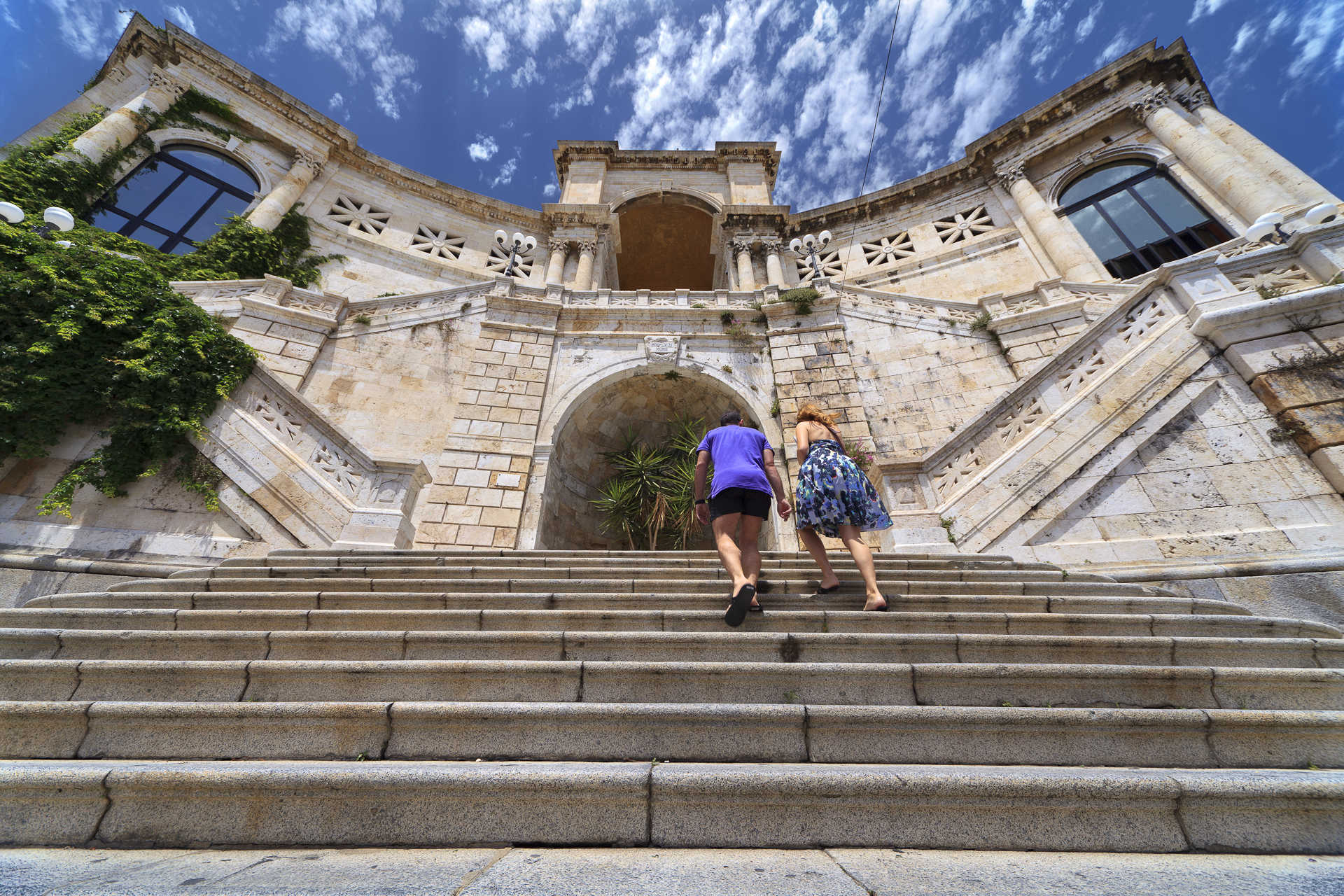
Saint Remy Bastion
Gateway from the Villanova quarter to the fortifications of Castello in the heart of the old city, the bastion that owes its name to the Baron of San Remy, the first Viceroy of Piedmont, looks out over Piazza Costituzione where the two streets that have historically been havens of leisurely strolls and shopping, via Garibaldi and via Manno, come together. It is without doubt a symbol of Cagliari, one of its finest and most majestic monumental complexes, as well as its most prestigious exhibition space.
The covered gallery and the marvellous Umberto I terrace were designed by Giuseppe Costa and Fulgenzio Setti based on an idea developed by the XIX-century architect Gaetano Cima. It was built in a Classic style between 1896 and 1902 on the old city’s medieval bastions. The San Remy Bastion is the result of the levelling and reuse of the old Sperone and Zecca bastions that had been built by the Spaniards in the late XVI century.
The imposing structure features yellow and white calcareous columns topped with Corinthian capitals. The main stairway is long and complex, going upwards from the piazza with a series of ramps that come together halfway up at a wide terrace. From here you can gain access to the gallery, which unites large, bright rooms decorated with lively colours and enclosed with high arches. Under the main arch that dominates the building is another stairs with two circular ramps that lead to the Umberto I terrace, from which you can enjoy magnificent views over the entire city and the sea. The square is home to two more ramps of stairs that lead to the Bastione di Santa Caterina.
The stairs and the triumphant arch, damaged by bombs in WWII, were faithfully reconstructed starting in 1946. Over the years, the wide open spaces of the gallery were adapted to a variety of functions: initially for use as banquet halls, then as an infirmary during the war, and later as a refuge for the homeless. In 1948 it hosted the first edition of the international Sardinia Fair.

Selegas
Selegas is at the heart of the Trexenta subregion, perched between two valleys at the foot of Monte Nuritzi. It is a town with 1,400 inhabitants and an agricultural tradition. The name derives from the abundant cultivations of rye - the ‘black bread’ of the Roman commoners - or from segetes, ‘cereals’, then ‘land of Ceres’, the harvest goddess. Even the urban structure is typically rural, with low-rising houses, their façades embellished with murals that depict the local activities and community and the ‘renaissance subjects’ of painter Liliana Cano. The Sa Domu De Perda event in July is dedicated to these wall paintings. In the ‘heart’ of the town is the parish church of Sant’Anna, in the Gothic-Pisan style of the 12th-13th century, enriched by its marble altar. The bell tower has four bells, the oldest (1608) being engraved with Seligas. The parish museum is connected to the church, which holds statues, liturgical books and sacred furnishings, dated from between the 16th and 19th centuries. The patron saint is celebrated at the end of July with a procession and events that express the deep-rooted customs of the town: an exhibition of garments, traditional music, dances and poetic competitions. Next to the parish is a cave dedicated to Our Lady of Lourdes. At the peak of the village stand the churches of Santa Vitalia, whose patron saint is honoured at the beginning of October, and Sant’Elia, built in 1810 on the ruins of San Pietro, on the possible site of a sacred Nuragic fountain in prehistoric times. Also worth visiting is the 16th-century Oratorio del Rosario and the ruins of Nostra Signora d’Itria, located in the most ‘Romanised’ area, attested by fragments of amphorae, jugs and ceramic crockery along with traces of the Carales-Olbia per Bioram. Another stretch of Roman road emerges in the village of Seuni, two kilometres from the town. An ancient and significant village, it is today populated by 300 inhabitants and preserves the Santuario di Santa Vittoria Martire, dating back to 1581 and rebuilt in the mid-20th century. The saint is celebrated in May, in the same month as the festival of Sant’Isidoro, patron saint of farmers, a much-anticipated event along with the carnival.
The heights of Selegas were inhabited as far back as prehistoric times. In Turriga, a statue of the Mother God in marble limestone was found, being 40 centimetres in height and today exhibited at the National Archaeological Museum of Cagliari. The work is similar to those found in the Aegean. Amongst the Bronze Age ruins stands the Nuraghe Nuritzi complex, of which the fortified tower still stands. The Nuraghe Simieri is connected to the Santu Teru of Senorbì, where a Nuragic masterpiece was found - the bronze of a horned soldier. It arises on the Bruncu Simieri, a clear weathering of ‘Monte dei Sumeri’, where the ziqqurat - temples - where usually erected on the peaks, in contact with the sky. It is not unlikely that in the Eneolithic era, a ziqqurat was knocked down by the Nuragic peoples to extract materials useful for building their settlement. Near the Nuraghe of Bruncu is Olias and Bruncu sa Figu, the remains of a Tomb of Giants and a sacred well emerge.
Vallermosa
The name of Vallermosa derives from the Spanish hermosa, meaning ‘beautiful and fertile valley’, in a word ‘ridente’ (Italian for ‘delightful’). Vallermosa, a village of the Iglesiente subdivision with around 2,000 inhabitants, lies in a valley bordered by two streams at the foot of Monte Cuccurdoni Mannu, on the eastern borders of the Monte Linas massif. It is 15 kilometres from Villacidro, thirty from Iglesias and 45 from Cagliari. The Campidanese houses in clay brick with artistic gates embellish the historic districts of Prazz'e Cresia, Cruxi Santa, Cabina e s'Ecca Manna. In the centre stands the parish church of San Lucifero, dating back to the 17th-18th century. In the countryside, the Santuario di Santa Maria can be admired, near which stand the Roman baths (3rd-4th century A.D.). The local festivals feature a jubilation of colours and sounds of traditional garments and musical rhythms. The patron saint is celebrated on 20th May, Santa Maria between 7th and 9th September with a procession from the parish to the country church and a spectacular torchlight procession on its return.
The great naturalistic attraction is the Linas. Covered by dense forests interlaced with streams and waterfalls, it has an alpine landscape with wild peaks, deep gorges and steep rock faces dating back some 300 million years. Amongst the pink and grey granite peaks are almost 8,000 hectares of holm oaks and various Mediterranean tree species, such as strawberry trees, lentisk trees and European olive trees. The lush vegetation is home to, amongst others, the Corsican red deer with the golden eagle flying overhead. A number of paths lead through the woods, to be traversed on foot, by bike or on horseback. In the territory around Vallermosa are lush hills, including one on which stands the park of Gutturu Mannu (‘Great Gorge’), five kilometres from the town, an enormous canyon zigzagged by a stream and covered by 35,000 hectares of forest, one of the largest green areas in Italy. It is a popular destination for trekking enthusiasts, with areas for resting and picnicking. The park is wildlife oasis, with fallow deer and mouflons wandering freely. Also to be discovered is the life of the civilizations of yesteryear in a stretch of land uniting history and nature. Four kilometres from the forest is the archaeological area of Matzanni, which houses a wall structure, three temples with a Nuragic well, surrounded by a village of 13 huts and the ruins of a Punic temple. The most precious artefact found is the small bronze ‘Barbetta’ statue, exhibited in the National Archaeological Museum of Cagliari. On a hill near the village stands the Nuraghe su Casteddu de Fanaris, from which picturesque scenery can be admired. The territory has been inhabited since the Nuragic period and again in the Punic-Roman period, but the origins of the town date back to the mid-17th century, in the context of the events of the Spanish feudal Sardinia: Blasco de Alagòn, the Marquis of Villasor, organised a massive migration of families to the depopulated villages of Pau Josso and Pau de Vignas. From here, the urban development began.
Serramanna
Serramanna lies in the central-western part of the Campidano plain, one of the most fertile areas of the island, where the Leni torrent intersects with the Flumini Mannu. Serramanna is a city of just under 10,000 inhabitants, which has always been based on agricultural production, especially wheat and vegetables. Today, it is one of the largest fruit and vegetable producers in Sardinia. The communal winery producing excellent wines and the still-active canning industry have enjoyed great renown. The historic centre is comprised of typical Campidanese houses, with entrance portal, courtyards, sas lollas and various environments for working and lodging, with highlights including the Casa Cadoni-Arcais and Casa Abis, with a long portico with pointed arches. Amongst the historic buildings to be admired is the Monte Granatico and the headquarters of the Società Operaia (operatic association).
The houses in the town are arranged around the San Leonardo parish church, built over in a number of differing periods, hence the Gothic-Catalan, Aragonese and late-Baroque fusion. It is characterised by a Latin cross layout and a tall octagonal bell tower, designed by the architect Antonio Calabrès. Also worth visiting are the churches of Sant’Ignazio da Laconi, and San Sebastiano, which housed the Dominicans between 1631 and 1854, and that of Sant’Angelo (16th century), which contains the Museo delle Memorie e delle Tradizioni Religiose with various thematic areas: precious and sacred furnishings with liturgical functions, sculptures, statues, silverware of sacred art and ex voto. In the countryside is the church of Santa Maria di Monserrat, dating back to the year 1000, cited in 1089 as part of a donation made by the Giudicato of Cagliari to the Benedictine monks. Serramanna was also a pilgrimage destination for the 2000 Jubilee. During the excavations carried out in the sacristy of the rural church, the most significant finding from the Nuragic age reappeared. Other Nuragic structures have been identified in Santa Luxeria. The first settlements within the Serramanna territory date back to the Neolithic village of Cuccuru Ambudu and the menhir Perda Fitta, a granite boulder representing the Mother Goddess. There were numerous rural villages during the Roman domination, with the remains from this time kept in the National Archaeological Museum of Cagliari. In the Middle Ages, Serramanna was divided into numerous Villas, including five main ones, whilst with the advent of feudalism, it passed through various noble families. In 1617, Antonio Brondo y de Ruecas was named the first count of Serramanna by King Philip III of Spain, an appointment that continues to this day.
Sanctuary of Sant'Anastasia
It stands in the upper part of Sardara, a village in the Medio Campidano area, and it gets its name from the little church nearby. The Nuragic sanctuary of Sant'Anastasia is characterized by a sacred well, known as funtana de is dolus (well of the pains), from which the spring emanates and is fed by groundwater aquifers. Thanks to a draining mechanism, you can enter it and admire its solid architecture, going right down to the bottom. Created with basalt and limestone blocks, perhaps in the Late Bronze Age, it has a circular room with a false dome roof, which you can get to via a flight of steps protected by a corridor covered with slabs in a jack arch arrangement. In the temple, of which only the well still remains, the water deities were worshipped, like in the Sanctuary of Santa Cristina (in Paulilatino), that has a similar structure but is perhaps from a later period.
The use of the area for religious purposes continued on after the Nuragic era, as is confirmed by Punic pottery and the remains of a Byzantine building beneath the church of Sant'Anastasia (rebuilt in the 15th century), in which there are two naves separated by pointed arches resting on pillars. Inside the church, there is another Nuragic well, of which several ashlars decorated with engraved patterns - one shaped like a taurine protome - are walled into its façade. In the well, which is smaller than sa funtana de is dolus, numerous pots from the Iron Age (8th century BC) were found. The excavations in the surrounding area have unearthed a large curvilinear enclosure alongside which there is a path of stone slabs. Inside it are the huts of a village that extends mostly beneath the current houses in Sardara. They are the remains of a vast Nuragic settlement, not just religious but also civilian, that continued on from the Recent Bronze Age to the Early Iron Age, and was also frequented in later periods. The enclosure incorporates a large circular hut, maybe a Council room, with a seat that runs along the perimeter wall. Here, as well as furnishing elements, among which a stone alter shaped like a Nuragic tower stands out, there are numerous artefacts unique in the Nuragic context: terracotta melting moulds, lead ingots and a pot containing precious bronze relics. You can admire them in the Abbas Villa city archaeological museum. Not far from the excavations, you can also visit Casa Pilloni, a dwelling that dates back to earlier than the 17th century and is currently a centre of services for the enhancement of the archaeological site.
Villa San Pietro
It stretches along the foot of Mount Punta Sa Cresia, half an hour from Cagliari. Villa San Pietro is a village with an agricultural and pastoral vocation and two thousand inhabitants, in constant growth since the end of the nineteen sixties, making it unique among the island's Municipalities. Its territory does not have an outlet to the sea, but it extends as far as the beach of large-grained sand and pebbles of Porto Colombu, near the tourist port of Perd'e Sali, not far from Pula and from its marvellous shoreline. In the hinterland, there is the lush forest of Monte Nieddu, which extends over granite massifs, and the green expanse of Is Cannoneris, a wildlife oasis repopulated with Sardinian deer and fallow deer and moistened by various watercourses. Forests of holm oaks, Mediterranean scrub and conifers disappear on the horizon: you can travel through them along well-marked trekking trails. From the summit of the territory, Punta Sebera, you can admire part of the Gulf of Cagliari and the southwestern coast.
The village, which emerged around the year one thousand, gets its name from the pretty Romanesque church of San Pietro. Built around the end of the 13th century, it has a single nave and a wooden roof. The façade is adorned with a belfry and an oculus. The interior was originally built with terracotta and granite slabs and the floor was entirely paved in stone. The celebrations in honour of the patron saint take place at the end of June. The evocative Festa di Sant'Efisio celebration takes place in stages: the saint's carriage passes through Villa San Pietro on 2 May and continues on through Nora; on 4 May, on its way back, it stops at Villa Atzori.
The first nucleus of the village was Roman, while the territory has been inhabited since the Nuragic age: there are three Tombs of Giants, Su Cuccumeu, Perda e’ Accuzzai and Su Lilloni, and the Mereu Nuraghe, which is still partially buried on top of a hill on the border of Sarroch, around which there may have been a village. The megalithic tomb was connected to the settlement, a few tens of metres away. The remains of other villages are in Porcili Mannu and Sa Sucraxia, located inside the forest. The most likely hypothesis is that they are the dwellings of families of Moors, enslaved by the Romans and forced to work in the mines of the Sulcis area. There is a necropolis near the ruins of the dwellings.
Villasalto
Nestled 500 metres high on a plateau that alternates sinuous forms with steep slopes and deep crags, the Gerrei town of Villasalto includes 1,000 inhabitants, having experienced a mining epoch thanks to the Su Suergiu mine, the foundry of which produced 90 percent of the antimony of all Italy, used for war purposes. Extraction and processing activities lasted a century (1880-1987) - also in the minor mines of Sa Lilla and Parredis - which took a downturn in the post-war period. Today, 19th-century buildings, a mining village and a building dating back to the beginning of the 20th century that houses an archaeological-mining museum, are precious ‘pieces’ of the Parco Geominerario Storico e Ambientale della Sardegna. The historic part of the town, whose name derives from saltus (countryside), arose around the 17th-century parish church of San Michele Arcangelo (the parish saint being celebrated at the end of September), which safeguards paintings and 17th-century wooden statues plus an organ from the 18th century. The most recent part was built around the Sanctuary of Santa Barbara, founded by Byzantine monks and rebuilt in the mid-19th century. For the patron saint of miners, the most adored festival takes place at the beginning of June. It is repeated on 10th July together with the Sagra della Capra (food fair dedicated to the goat). Tastings of meats and cheeses can also be enjoyed in spring with the su Sinnadroxiu. In mid-January, bonfires are lit for celebrations dedicated to Sant’Antonio and San Sebastiano. A much-anticipated event is the is Animeddas, the Sardinian version of Halloween.
The territory of Villasalto is one of the wildest and most evocative in the south-east, rich in springs and covered with holm oaks and oaks. To the east, it overlooks the valley of the Flumendosa, from where one can spy a succession of imposing ramparts that fall on the riverbed and frame the woods. Granitic slopes and spiers of Mount Genis, an elevation that separates the Villasalto plateau from the Sarrabus and a fauna oasis inhabited by mouflons, are covered by a centuries-old holm oak wood. From the summit, the panorama embraces the northern Tacchi d’Ogliastra and Gennargentu, to the south the Sette Fratelli park. Amidst the Mediterranean scrub, there are bizarre rocks carved by time, as if an eagle were perched on top. To the west, the plateau is bordered by Mount Arrubiu and its forest, populated by a colony of deer. Here, the remains of a village and the Roman necropolis of Cea have emerged, a mysterious settlement perhaps linked to the argentiferous veins in the area. Other itineraries to be explored include those of the valleys of the Rio s’Acqua Callenti and on the promontories of Monte Lora. Nearby, sa Grutta ‘e Scusi open up, a hollow that is famous for cave formations and the presence of ‘geotritone’ (cave salamander), a Sardinian endemic reptile. On the Genis, at 700 metres above sea level, there is a large Nuragic complex, sa Dom’e sa nì (‘house in the snow’), consisting of tower, walls and circles (huts or places of worship), used in modern times to preserve ice. From below the eastern ridge of the mountain, the Nuragic village Arcu ‘e sa Tuppa arises. There are other Nuragic structures, the Pala Perdixi complex and the Tomb of Giants of Aligamu.