Memories of ancient merchants
From Sinis to the southern beaches, through the ‘market towns’ founded by the Phoenicians, strategic bases for commercial traffic and places of contact with the last Nuragic civilizations


From the 9th century BC, Sardinia was also involved in the commercial expansion of the peoples commonly referred to, in the western Mediterranean, as Phoenicians. Born as trading emporiums, the settlements that arose on the coasts of the Island - or not far from them - evolved into thriving towns that, starting in the 6th century BC, fell under Carthaginian rule and then under that of Rome. Some, which developed into modern residential areas, still exist today. Between the Phoenicians and the Nuragic communities - whose civilisation was coming to an end - there were apparently no clashes: the towns in the itinerary were examples of multiculturalism, mutual exchange, knowledge and peaceful coexistence.
The journey going almost three thousand years back in time starts on the central-western coast, alternating between the sea and the inland area in Sulcis and ends on the marvellous coasts of Chia and Nora.
Itinerary: 250 kilometres
Road travel time: four hours
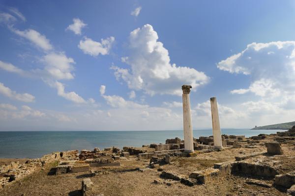
L’itinerario parte dall’estremità meridionale della penisola del Sinis, tra capo San Marco e la borgata di San Giovanni. Tharros è uno dei migliori esempi di ‘evoluzione’ di un insediamento nel corso dei secoli. Le primissime tracce sono nuragiche, ai fenici sono ricondotte necropoli e tophet, poi in epoca punica e soprattutto in quella romana la città si sviluppò pienamente. Passeggiare tra le sue strade con lo sguardo rivolto al mare è un’esperienza indimenticabile.
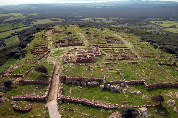
Si scende di 140 chilometri a sud. Sulla cima di un monte sorge il parco archeologico di Monte Sirai. La posizione garantiva alla città fenicia, poi punica, il controllo sul mare. L’area ‘civile’, sviluppatasi attorno al tempio di Astarte e fortificata a nord nel III secolo a.C., e le aree funerarie sono separate. In una tomba punica compare il misterioso simbolo di Tanit, mentre più ‘staccato’, a nord-ovest, c’è il tophet. La città che visiterai è quella punica, Roma costruì più a valle.
Una delle più antiche città italiane, se non la più antica in assoluto. Sulki fu fondata sul golfo di Palmas nell’VIII secolo a.C., poco prima di Monte Sirai. La fattura di alcuni tegami del tophet fornisce indizi sulla ‘collaborazione’ produttiva tra fenici e nuragici. In epoca punica la città riprese vigore: la necropoli, con migliaia di sepolture, è tra le più grandi del Mediterraneo. A ridosso del forte sabaudo ammirerai l’acropoli, dove si trovavano i due leoni oggi conservati al museo MAB.

‘Route’ heading south-east, just over sixty kilometres to get to the splendid beaches of Chia. The remains of the ancient city of Bithia can be found around the easternmost beach, that of Su Portu. It was a thriving Phoenician port that was also conquered by the Carthaginians and then by the Romans. To see the meagre traces of it, you can explore the slopes of the promontory on which the tower of Chia stands, while the Phoenician tophet and a Punic temple may have been located on the islet of Cardulinu, which you can get to on foot.

The remains of the city of Nora, 19 kilometres north-west of Chia, are much more evident. A short distance from the small church of Sant’Efisio, the arrival point of the most impressive procession on the Island, lies a town ‘recovered’ by the sea. In reality, you’ll be visiting the Roman town, because the Phoenician-Punic buildings were almost completely replaced by the Roman ones, although it was from the tophet that the rediscovery of the thriving port city began. A stele found here displays the name Sardinia for the first time.


