
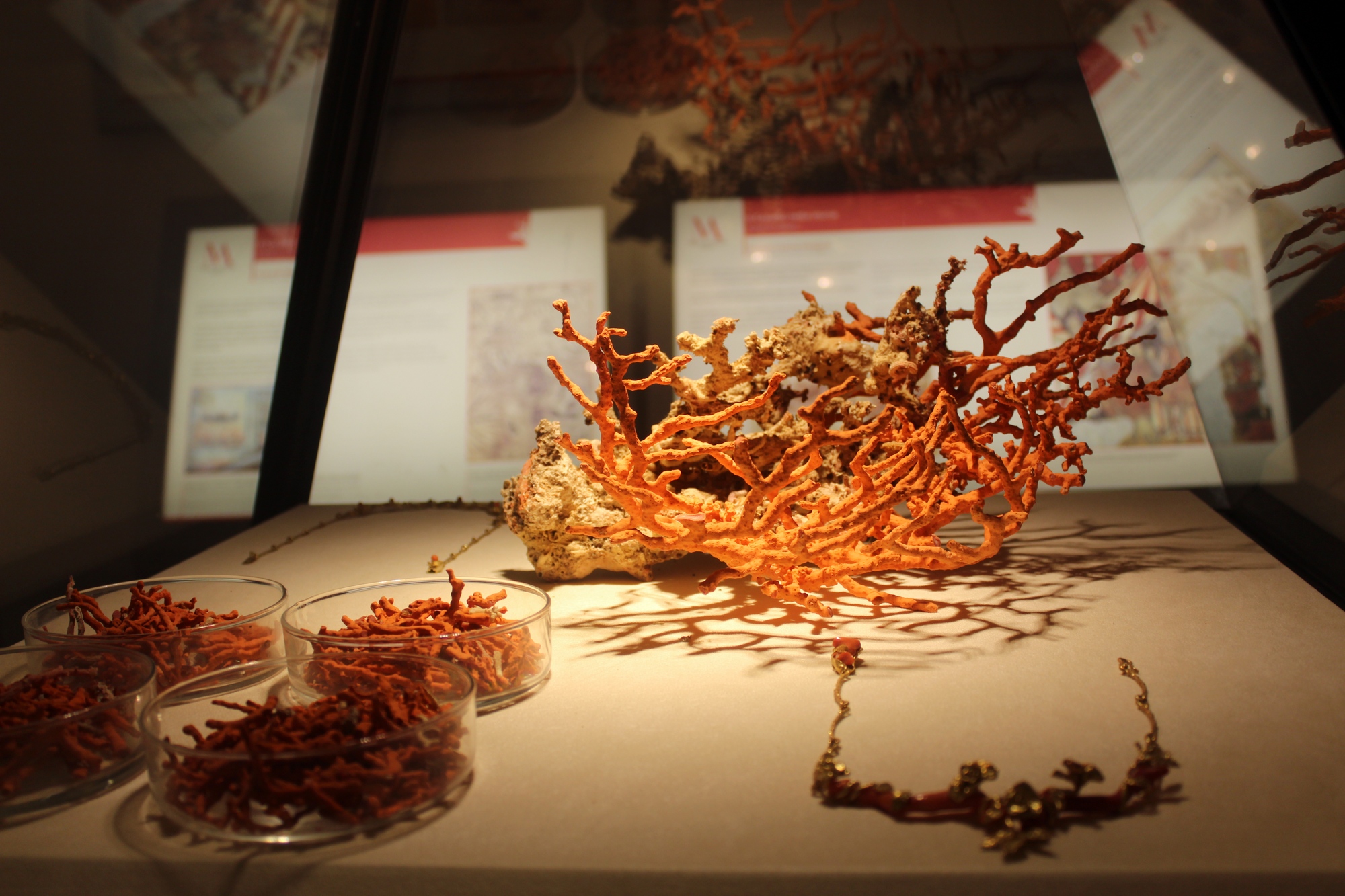
Coral museum
A dive into the sea at Alghero to uncover one of the its principle natural products, the city’s emblem, the item to which it owes great part of its fame and fortune: corallium rubrum. The Coral Museum is in the lovely Art Deco Villa Costantino that takes its name from the family that had it built, in 1927, outside the city walls, not far from bastions that were later demolished. Every display within the museum centres around the precious ‘red gold’.
The exhibition space was completely restyled and renovated in 2016 and focuses on the culture, history and identity of Alghero by way of the historical, scientific and economic significance of this prized material, as well as looking at some interesting anecdotes associated with it. But above all, it will introduce you to the works of art the craftsmen of Alghero have created, and still craft, with coral.
A fascinating journey into the marine ecosystem of what, with good reason, is known as the Coral Riviera, some 90 kilometres of coastline blessed with an infinity of scenery, and into the history of this precious living organism. Coral was the preferred catch of divers even in pre-historic and early history, when it was used in worship rituals, in connection with blood and, therefore, with life itself. Over the centuries it gradually became a valuable commodity that today is safeguarded in special underwater sites inside the Capo Caccia protected marine area within the Porto Conte regional park.
The Coral Museum is one of the cornerstones in a string of cultural proposals that together are known as the Musei Alghero, which includes three other museums (Archeologico, Diocesano d’Arte Sacra and Casa Manno) and a wide variety of archaeological and cultural sites.
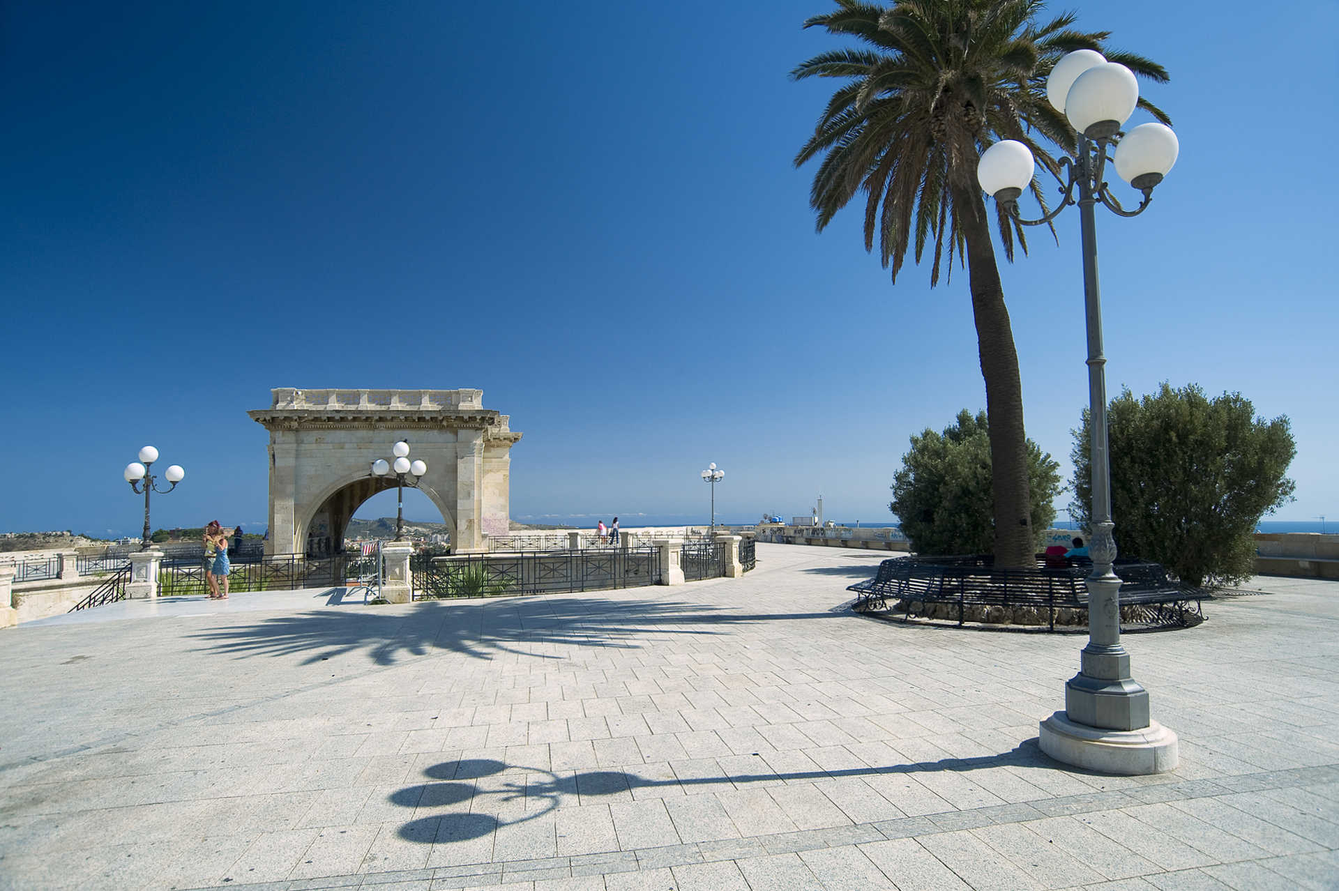
The city hall - Cagliari
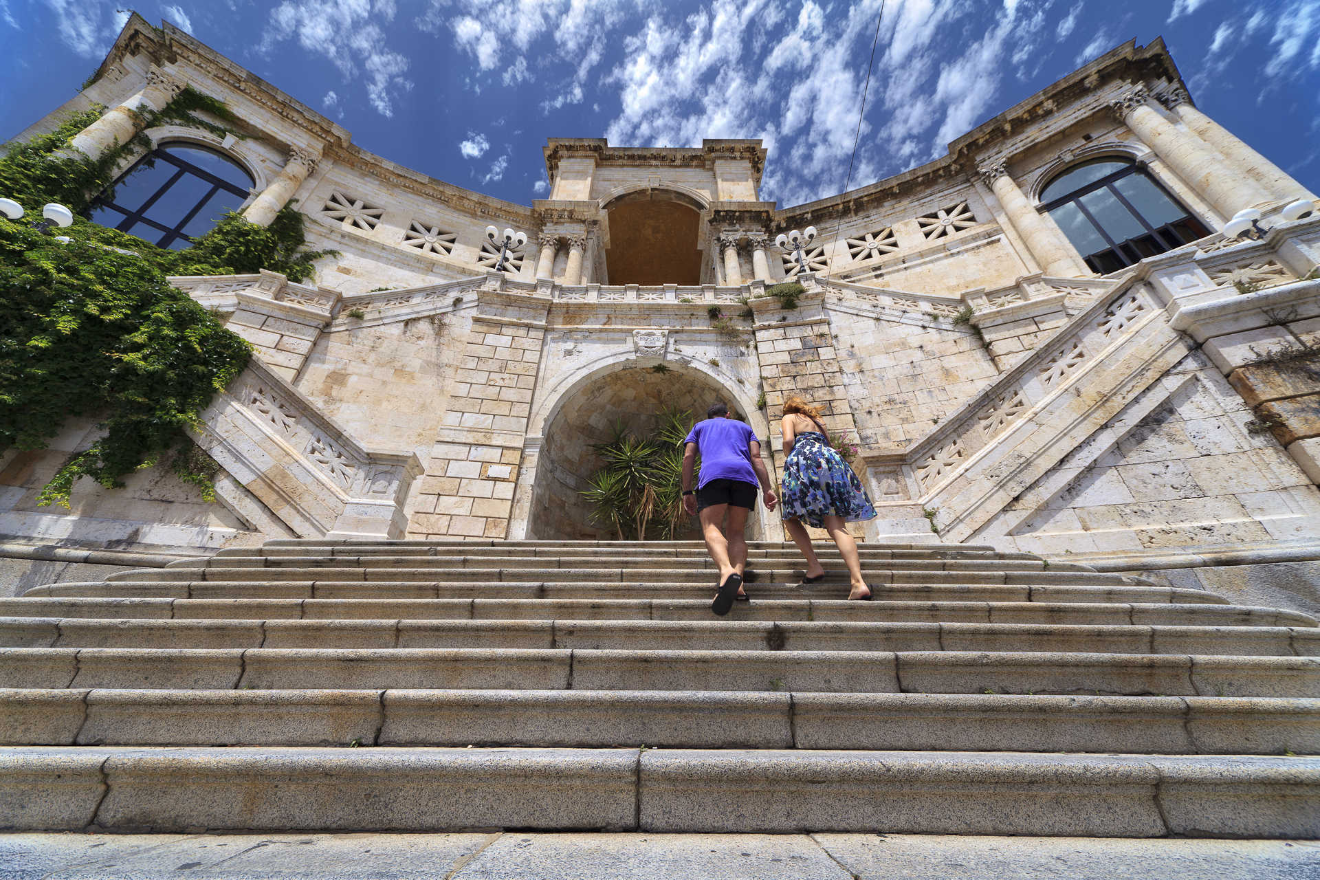
Cagliari’s Palazzo Civico, or City Hall, rises above the harbour like a bastion of white stone, elegant in shape and colours, perfectly in tune with the other old buildings that line Via Roma. City Hall was originally located at Piazza Palazzo in the Castello quarter, fortified higher part of the city and symbol of its defence. Thanks a the far-sighted initiative of Mayor Ottone Bacaredda, the city’s main institution was moved to the more popular Marina quarter adjacent to the Stampace quarter by the seashore, a sign of changing times. In 1896 the city’s councilmen had deliberated that the seat of government should leave the city walls and head down towards the harbour. The building’s design was based on a Gothic-Catalan model and constructed with white calcareous rock graced with art deco embellishments. It was solemnly inaugurated in 1907. The move was an expression of a new political trend that reflected the ideas of the business class: visibility, comparison and openness, a radical departure from aristocratic pride and diffidence. Cagliari presented itself to the world as a modern city with an impressive ‘visiting card’: a new City Hall that was not spared the bombing raids of WWII and thus rebuilt between 1946 and 1953.
The building can be visited like a museum and occupies a city block set between Via Roma, where the main entrance is, Via Crispi, Angiogi and Largo Carlo Felice. The façade is graced by a portico of seven arches plus the central arch, which leads to the courtyard. At the top are two 38-metre high octagonal towers, while four obelisks decorated with the heads of the Four Moors adorn the corners. Works in bronze by Andrea Valli grace the prospects: an eagle holding up the city’s emblem, two lions and allegorical representations of Agriculture, Commerce and Industry. A two ramps of stairs lead to the upper floor. In the Consiglio hall are three important works by artist Filippo Figari. The nearby Giunta hall is home to the Gonfalone and the XVI-century retable of the Consiglieri. In the Wedding Hall is a work by Figari depicting a Sardinian wedding, as well as a variety of beautifully crafted artisanal furniture. There are also jewels, archaeological relics and the simulacrum of St. Agostino. In the mayor’s room is a large 1620 Flemish tapestry, and in the Savoy room three works by Maghinotti: portraits of Vittorio Emanuele II, of Carlo Alberto and his arrival in Cagliari in 1840.
Riu Mulinu
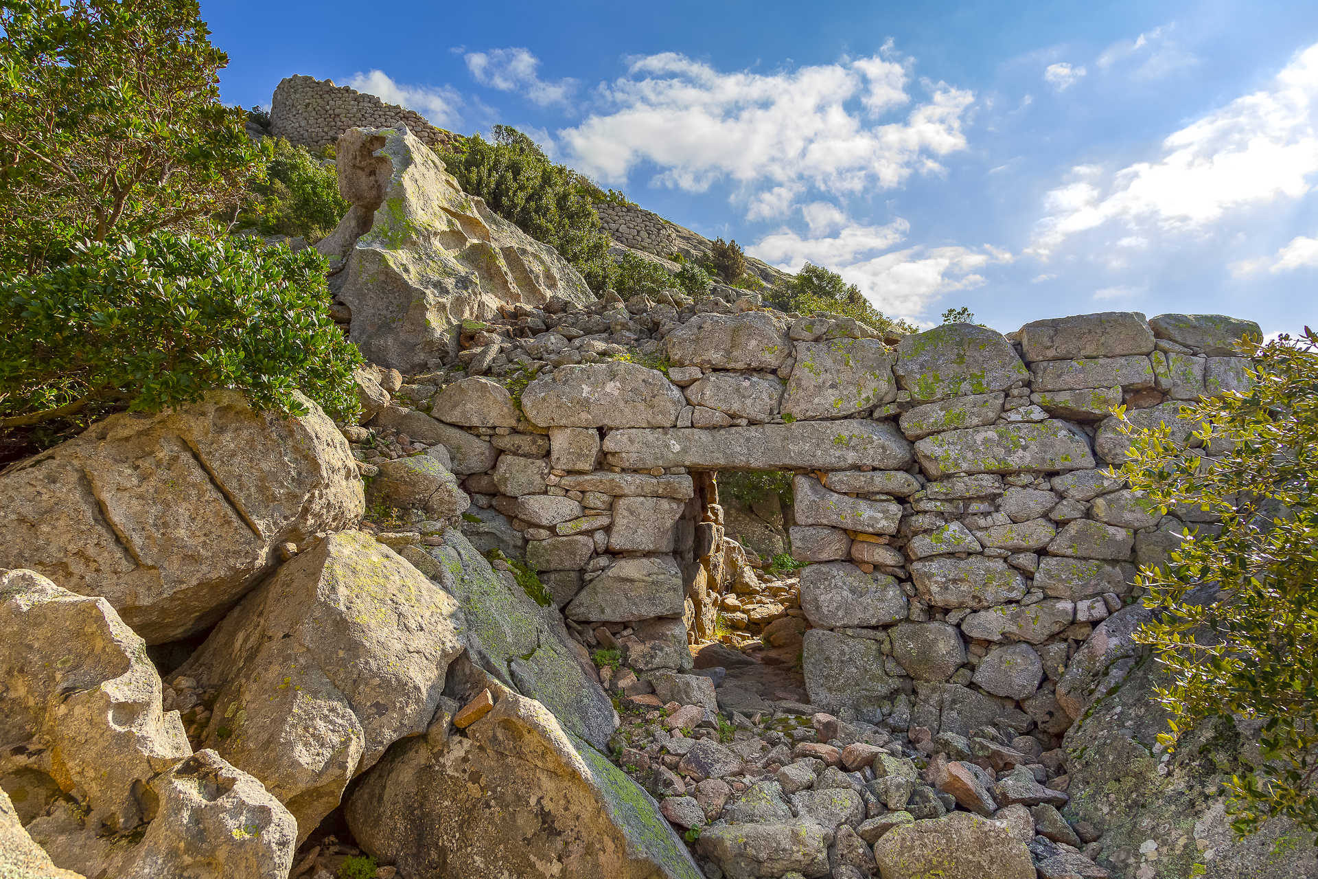
From its almost 250 metres high strategic outlook on Cabu Abbas, it kept watch for enemy ships, its view over the horizon stretching all the way to Tavolara island. The Riu Mulinu nuraghe is one of the best known Nuragic fortifications in the northern part of the island. It rises just a few kilometres from Olbia and dates to 1300-1200 BCE. The main tower is well protected by a great 220 metre long wall that encircles the hilltop with widths and heights of up to five metres at some places. What distinguishes this wall is that it envelopes rocky outcrops along its perimeter. There are two entrances, a southern and a northern. Inside is a circular tower with a diameter of about eight metres.
Constructed with blocks of granite, the nuraghe has a corridor with small niche and stairs that once led to an upper level, no longer open. The area below the stairs leads to a sacrificial pit where burned bone fragments and ceramic bits were uncovered. Archaeologists began digging here in 1936 and have found a small bronze statuette of a woman with an amphora on her head. This important find allowed scientists to date the site and declare it one where sacred rites of water worship were performed.
Riu Mulinu is Olbia’s most important Nuragic site, but there are two other important monuments from the 2nd millennium BCE: the sacred sa Testa well, another shrine of water worship just outside of town, and the Giant Tomb of su Monte de s’Aba (or de s’Ape), unusual because it served as a common grave where the dead were buried together. Olbia (which means “happy” in Greek) was first settled by Phoenicians and Greeks and then came under the Romans, who, among other things, built an aqueduct, thermal baths and a s’Imbalconadu, a typical Roman farm. To complete your tour of the history of the city, continue your journey through the eras at the Archaeological museum located on the small island of Peddone inside the museo della necropoli under the beautiful Basilica of San Simplicio, the city’s patron saint.
Botanical garden - Cagliari
A large green space in the historic centre of Cagliari is home to thousands of plant species from all over the world, some of them very rare, and at its core is an archaeological area that houses a large number of Roman remains. The Botanical Gardens are shaped like a trapezoid and cover an area of about five hectares at the lower end of the Palabenda valley, in an area that includes the Anfiteatro romano, Orto dei cappuccini vegetable garden and villa di Tigellio, where there are other Roman domus remains and what was once a thermal baths. The idea of creating a botanical garden in the valley came about in 1820. It had once belonged to the Jesuits, then to the ruling family, to a series of private individuals and was then purchased by the university. Work on the project began in 1864 under the guidance of the founder Patrizio Gennari, who modified the original project designed by the architect Gaetano Cima.
His touch can be seen at the far end of the valley, which is graced with a series of symmetrical lawns on either side of a main path that leads from the entrance to the fountain of the central square and then on to a pool with a majestic ‘marsh cypress’ and Fontana Pampanini. It is here that you’ll see the oldest of the garden’s plants. On the left hand side of the main path are desert succulents separated into plants from Africa and neotropical flora, and the arecaceae (palms) of the palm tree stand, where an oasis habitat has been created. To the right is a Mediterranean woods, with bushes and trees typical to the Mediterranean wilderness, and an herb garden that is home to commonly used medicinal plants that even science considers the most efficient in terms of herbal cures. A new section devoted to geophytes was very recently (2009) added and boasts some 200 species. A stairway leads from the lowermost part of the garden back up. The Gennari Grotto, the clover pool, the Roman cave, the raised walkway, the germplasm bank and the botanical museum are all also well worth a visit. And you must stop in at the Roccaglie biodiversity area, a display set up in 2004 that recreates the conditions under which a variety of plants grow in a rocky terrain in nature. Some 90% of the endemic, rare and threatened species from western Mediterranean islands, particularly Sardinia, are preserved here. Each section is divided into thematic subdivisions.

Su Motti
A panoramic road from the historical centre of the town of Orroli, that then looks out over it and leads to two ‘memory trails’, will take you back in time to the archaeological and botanical park known as su Motti. The trail that goes off to the left is an easy walk leading to the area of the stone domus de Janas chamber (homes of fairies) while the one leading to the right will take you to the Taccu Idda high plain to gaze out over breathtaking views. The woods are comprised of centuries-old oak trees and thick Mediterranean brush graced with the distinct fragrance of mastic and rockroses. Traces of man’s settlement here date to the Neolithic Era (3800 BCE) and it is dotted with massive basaltic boulders spewed out by nearby monte Pitziogu, a volcano that last erupted during the Quaternary Era.
In the surrounding park you will find a few single-tower nuraghes and an underground necropolis that is home to some fifteen stone domus di Janas chambers, pre-Nuragic tombs cut into the rocky face of sa Carona Arrubia and in great basaltic boulders. Some fabulous legends surround the huge masses, like the one about the terrible giant Impolla, a local symbol. The legends were handed down word of mouth over generations and imbue these prehistoric remains with a mysterious aura. Su Motti is an open-air museum that also has roots in XIX century history, when parcels of land were allotted and dry walls of basaltic rock went up to create is tancas, enclosed lots of land. The walls bear witness to the age of private property. The fencing in of the land was sanctioned in 1823 and lead to class conflicts between farmers and shepherds as herds had always gone to pasture on the open fields, considered the property of the entire community. Don’t miss the chance to see the sa Ucca Manna (large mouth) cave where the water from nearby streams and rivers converges. The grotto is full of long, intact stalactites. You can start off from Orroli to go on walks in nature and to see sites, go on a boating excursion on Lake Flumendosa and hiking to the unique five-tower Arrubiu nuraghe, covered in a fine mantle of red lichen, go to Sadali and stroll through its historic centre after stopping in at the casa museo di zia Carmela, see the water mill, the San Valentino waterfall and the Is Janas caves, steeped in legends featuring witches and fairies who remain petrified within. Take a trip to the valle dei nuraghi of Isili, to San Sebastiano lake to see the eponymous church that sits on an island at its centre, and walk in the woods surrounding Santa Sofia and Villanova Tulo.
Giants' tomb of Mont’e s’Abe
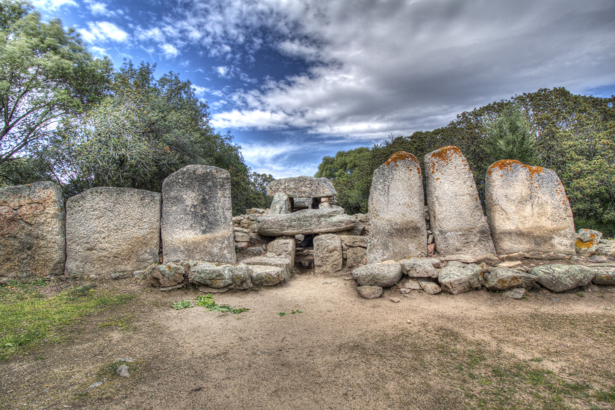
Facing the Pedres Castle, near Olbia, a veil of mystery surrounds a Nuragic burial ground. Unlike the thousands of other graves of its kind, at the su mont’e s’Aba (or s’Ape) Tomb of the Giant the deceased were buried together. The sacred rites were performed in the funerary room but, unlike elsewhere, no funerary documents were found in the sacred well to accompany the dead to his or her encounter with the divinity.
The building was constructed in two phases. In the first phase, which dates to the period of the Bonnanaro culture, the tomb was built in the allée couverte manner, a sort of elongated dolmen. Then, around the year 1600 BCE, it was transformed into a Tomba di Gigante (literally Tomb of the Giant) with exedra and stele, traces of which can still be seen. The building, which was originally built in the shape of a bull’s head, the divinity responsible for generating life, had a semicircle in front of it.
At the centre of the exedra is a four metre tall granite stele and, at the base, a small opening that led to the funerary chamber within. This chamber is ten metres long, while the entire structure outside, still visible today, is 28 metres long and six wide, one of Sardinia’s largest.
Other remains of Nuragic civilization in the area around Olbia are the Riu Mulinu nuraghe, one of northern Sardinia’s most important prehistoric monuments, and the sa Testa sacred well, where rituals associated with water worship took place. Olbìa, which means “happy” in Greek, was founded by the Greeks and later became a Roman colony. Fascinating traces of Roman domination are still evident today: an aqueduct, thermal baths and s’Imbalconadu, a typical Roman farm. To fully complete your cultural tour of ancient Sardinia, do not miss a visit to the unique Archaeology Museum on the little island of Peddone. Here you will embark upon a journey into distant eras of the past, and to the necropolis museum underneath the lovely Basilica of San Simplicio, the city’s patron saint. And, finally, the iridescent ceramic dome of the Church of San Paolo will be the star of many of your photos.

Saint Ephysius, the festival of Sardinia
The rustling and increasing sound of footsteps, the rhythm of hooves and carriage wheels that advance in unison. Cagliari is crossed once again by a procession of 2500 people in traditional dress, coming from all over Sardinia, followed by 270 horsemen - those of Campidano, the Militiamen and the Guardiania. A combination of colours, costumes, the sound of the launeddas and the is goccius devotional songs: from 1 to 4 May, we celebrate the Festival of Saint Ephysius. The early 4th-century events linked to the warrior saint are re-enacted and the perpetual vow addressed to him during the plague of 1652 is renewed. An entire island stops to repeat a ritual that has lasted almost four centuries.
Sardinia unveils its architectural treasures
Artistic magnificence, shared memory, identity and a sense of community: this is the most encompassing effort to safeguard, enhance and promote the cultural heritage of Sardinia. Following in last year's footsteps, the 2025 edition — the 29th — will once again take place in two phases, stretching across nine weekends: from May 3 to June 1 for the first phase, and then again between October and November. Hundreds of cultural sites will open their doors during this time, such as museums, archaeological sites, churches and historical buildings, natural monuments and parks. Each town will tell its tale through literary itineraries, architecture routes in cities that have been marked by centuries of powerful rulers. Students and volunteers are warming up to lead you along a travel through the beauty that crosses millennia, all the way to the farthest past. Places of yesterday and today, where memories of the past and ideas aiming towards the future coexist.

Bassa Trinità
On the northernmost stretch of the coastal road that runs along the entire perimeter of the island of La Maddalena you’ll find the enchanting beach of Bassa Trinita. It is shielded between a 128-metre-high rocky spur, once used as a military battery, and small granite coves connected to each other. The name comes from an ancient church, called ‘Della Trinità’, which was built immediately after the occupation of the island (in 1767) and stands in the centre of a small village once inhabited by Corsican people.
The location is a place of worship deeply heartfelt by the islanders and this area is also very popular with sea lovers. Downstream of the church, the beach was originally called abbassu à Trinita, which means ‘under the Trinity’. It has fine-grained white sand and is surrounded by granite rocks emerging from the sea. The seabed is sandy with shallow waters reflecting shades of turquoise, blue and green. Behind the beach, Mediterranean scrub is the protagonist, enriched by numerous plant species typical of the Gallura coast. The area is equipped with all the bathing facilities you need, as well as convenient parking and refreshment areas. From Bassa Trinita, you can trek along a nature trail that takes you on a visit of the entire surrounding area.
After exploring the nearby area, carry on to visit all 45 kilometres of the coast of La Maddalena: the inlets and little coves are bordered by granite and porphyry rocks. To the north, you’ll find rocks shaped by the wind and beaches of white dunes similar to Bassa Trinita, like Cala Lunga and Monti d’a Rena. To the east, just beyond the isthmus that connects La Maddalena to Caprera, Spalmatore offers you a captivating landscape. In Cala Francese there are several paths that allow you to discover the silent bays and dreamy beaches. In the southwestern part, following the Padule, seafront, you come to the enchanting Nido d’Aquila. Not far away, another marvel awaits you: Punta Tegge.
Spring in the villages
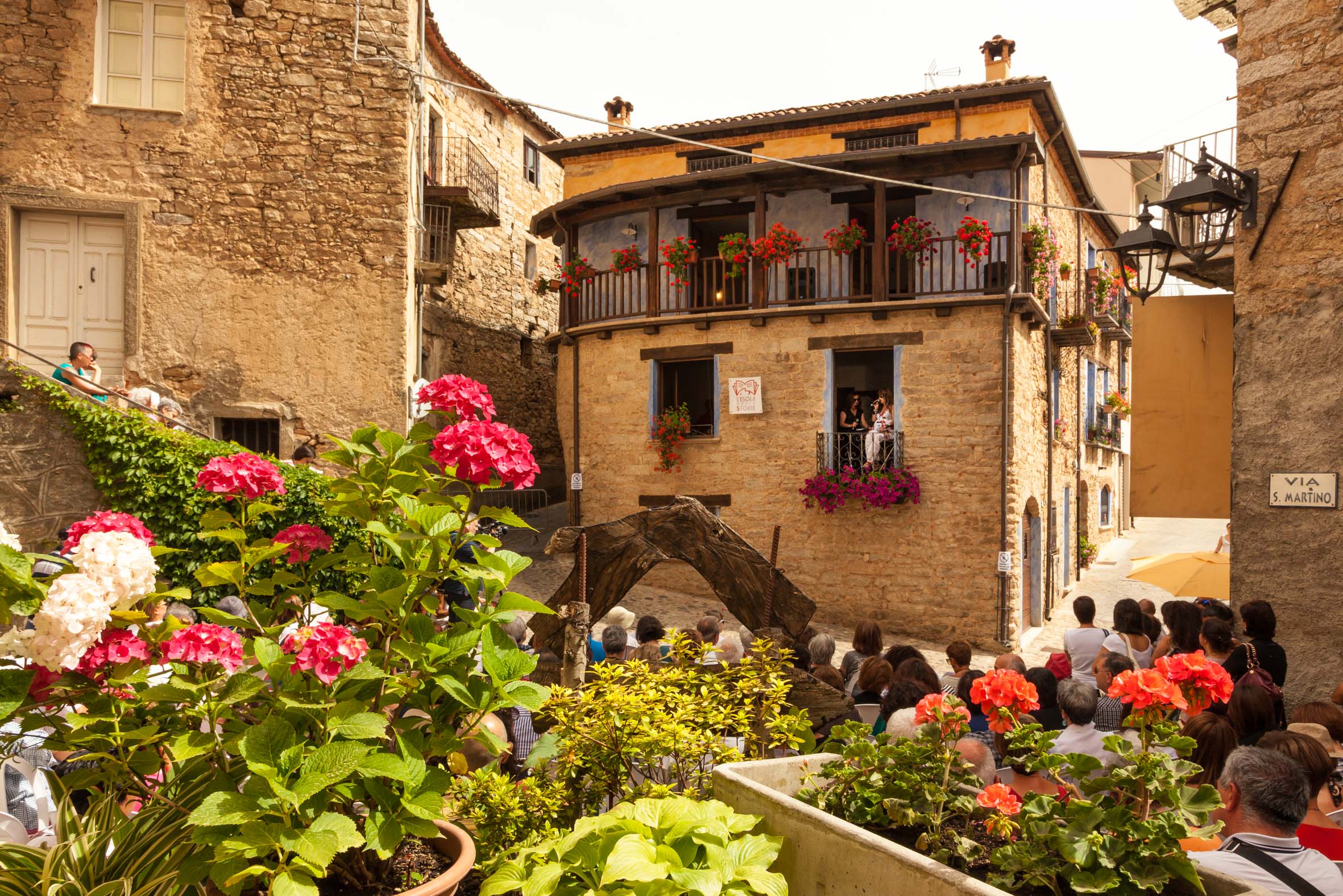
The explosion of spring colours on the island are in harmony with one of its most typical ‘picture postcard’ views: the colourful houses of Bosa. Walking along the Temo River, you can admire their reflections in the water, climb the hill dominated by the Malaspina Castle and, by crossing the Ponte Vecchio bridge, you will reach the south bank and discover the ancient tanneries. You will be welcomed by a glass of malvasia wine and impressed with coral jewellery, asphodel baskets and precious textiles. Bosa is a concentrate of history and craftsmanship, industrial archaeology and special treats. Do not miss the churches: the ‘cathedral’ of the Immacolata Concezione, Nostra Signora de sos Regnos Altos inside the castle, and san Pietro extra muros, at the centre of Bosa vetus. And then there is the natural beauty: the park of capo Marrargiu , the reserve of Badde Aggiosu and, on the coast, Bosa Marina, s’Abba Druche and Compoltitu.