

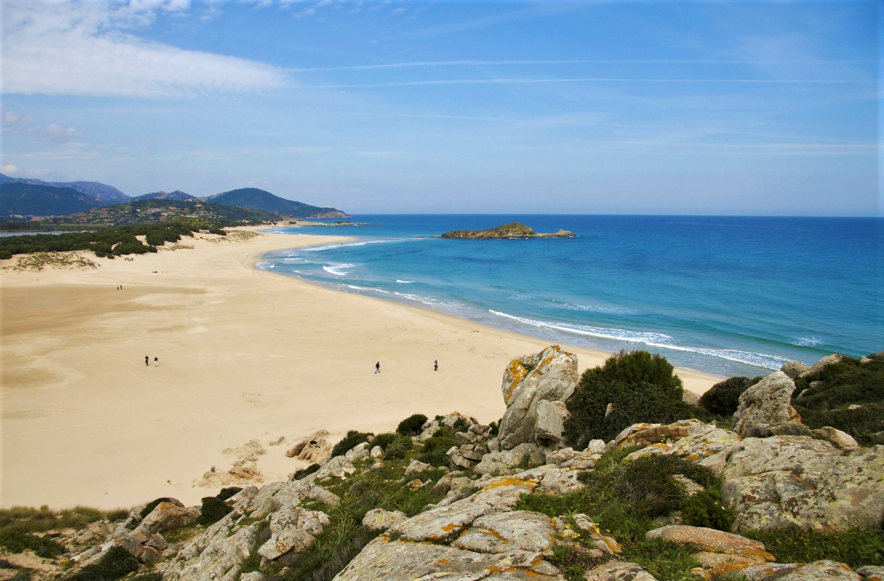
Cala del Morto - Chia
Many consider it the most beautiful of the seven ‘sisters’ that make Chia one of the most captivating and popular coastal destinations on the Island, perhaps because it is a small cove bordered by two rocky ridges or thanks to the pink granite rocks dotted across a carpet of fine, golden sand. Cala del Morto is the most intimate and sheltered of the beaches in the coastal district of Domus de Maria. The origin of the name ('dead man's cove') is linked to a cross, between the rocks, that has given rise to various stories and legends over the years. A short walk, lasting a few minutes, will take you to the beach, from the car park of the adjacent Porto Campana, along a scented path surrounded by myrtles, junipers and lentisks, before diving into the immense beauty.
The cove is ideal for those who want to be in close contact with nature: there are no services, just sand, cliffs that shelter you from the winds, pink-coloured rocks and a crystal clear sea, with shimmering colours of blue and emerald green. The waters are shallow, with a sandy seabed, populated by a variety of marine fauna, attracting numerous snorkelling enthusiasts. You can also reach it by sea, by canoe or by standup paddleboard from one of the adjacent beaches. In fact, there are two larger beaches equipped with numerous services on the sides of the bay: to the east, linked to Cala del Morto by another path, you will find the beach of Monte Cogoni. Although it gets its name from the green elevation behind it, it is actually the extension of the beach of sa Colonia. The latter is characterised by white sand and the presence - on the east side - of ashlars dating back to the Phoenician-Punic age and referring to the ancient city of Bithia, the acropolis of which was located on the promontory where the sixteenth-century tower of Chia stands. Monte Cogoni is more exposed to the winds, making it perfect for windsurfing and kitesurfing. To the west of Cala del Morto lies the Campana Dune shoreline, also known as Porto Campana. The name reveals the presence of sand dunes, on top of which rockrose bushes and sea daffodils emerge. Vegetation, rocks, golden sand and a turquoise sea will give you the impression of being on a beach in the tropics. Another cliff interrupts the expanse to the west, beyond which the most famous beach of Chia, often a setting for films and TV commercials, begins: su Giudeu. Crystal clear water, fine, light sand, the islet of the same name opposite and a pond inhabited by pink flamingos: it is a destination not to be missed. Its continuation is s’Acqua Durci, also dotted with dunes and with very shallow waters, making it ideal for children. After another promontory, you’ll find the seventh (splendid) sister, Cala Cipolla.
S'Acqua Durci - Chia
Perhaps a little less glamorous than its ‘neighbour’, but equally charming, also because it has all the right elements: a crystal clear sea, golden sand and dunes, breathtaking views and all the comforts you need. S’Acqua Durci is the westward extension of the beach of Su Giudeu. Together, they form Chia’s most famous stretch of coastline and a coastal ‘pearl’ of the Domus de Maria territory. The beach is often turned into a film set or a location for shooting commercials with a strong visual impact. The waters are shallow for several metres and the seabed is sandy, so the beach is suitable for families with children. There is also a refreshment area with the possibility of renting beach umbrellas, sun loungers and boats. Above all, you will be enchanted by the colours of the sea, as they change from turquoise to emerald green, with a few rocks emerging from the water.
The view of the sea is dominated by the islet of Su Giudeu, an 18-metre-high rock, which you can get to by swimming or, during low tide, by ‘walking on the water’. The dunes rising out of the fine, soft sand of the beach sometimes have bushes and shrubs growing on them. Along with those of Su Giudeu and the sandy ’little hills’ that characterise the beach even further east and, not by chance, called Campana Dune, they make up the Spartivento dune formation. Speaking of names, S’Acqua Durci, or ‘fresh water’, is a reference to the system formed by two ponds, connected to each other, extending behind the two beaches. The biggest one,Stangioni de su Sali, occupies the space behind the beach of su Giudeu, while you will find the second one - known as the ‘little pond of Stangioni de su Sali’ - just behind the beach of S’Acqua Durci. The complex is inhabited by various birdlife species, which attract passionate birdwatchers: you will be able to admire red herons, black-winged stilts, western marsh harriers, pink flamingos and Audouin’s gulls. S’Acqua Durci is the second to last beach of Chia along the road running from east to west: a promontory covered in vegetation separates it from the small bay where Cala Cipolla lies. It is an arch-shaped stretch of golden sand set between pink granite reefs extending into the sea, almost forming a natural swimming pool. Here too, you will find shallow, transparent waters, ideal for exploring with a mask and snorkel. Then, to the east, beyond Su Giudeu and Campana Dune, lie Chia’s other beaches: Cala del Morto, cosy, sheltered and also coloured by pink granite rocks; Monte Cogoni, a popular destination for water sports; Sa Colonia, an expanse of white sand close to the Phoenician-Punic remains of the ancient city of Bithia, and Su Portu, ‘watched over’ from above by the tower of Chia, dating back to the 16th century, and from which you can reach the islet of Su Cardulinu, where you will find traces of a Punic temple and a Phoenician tophet.

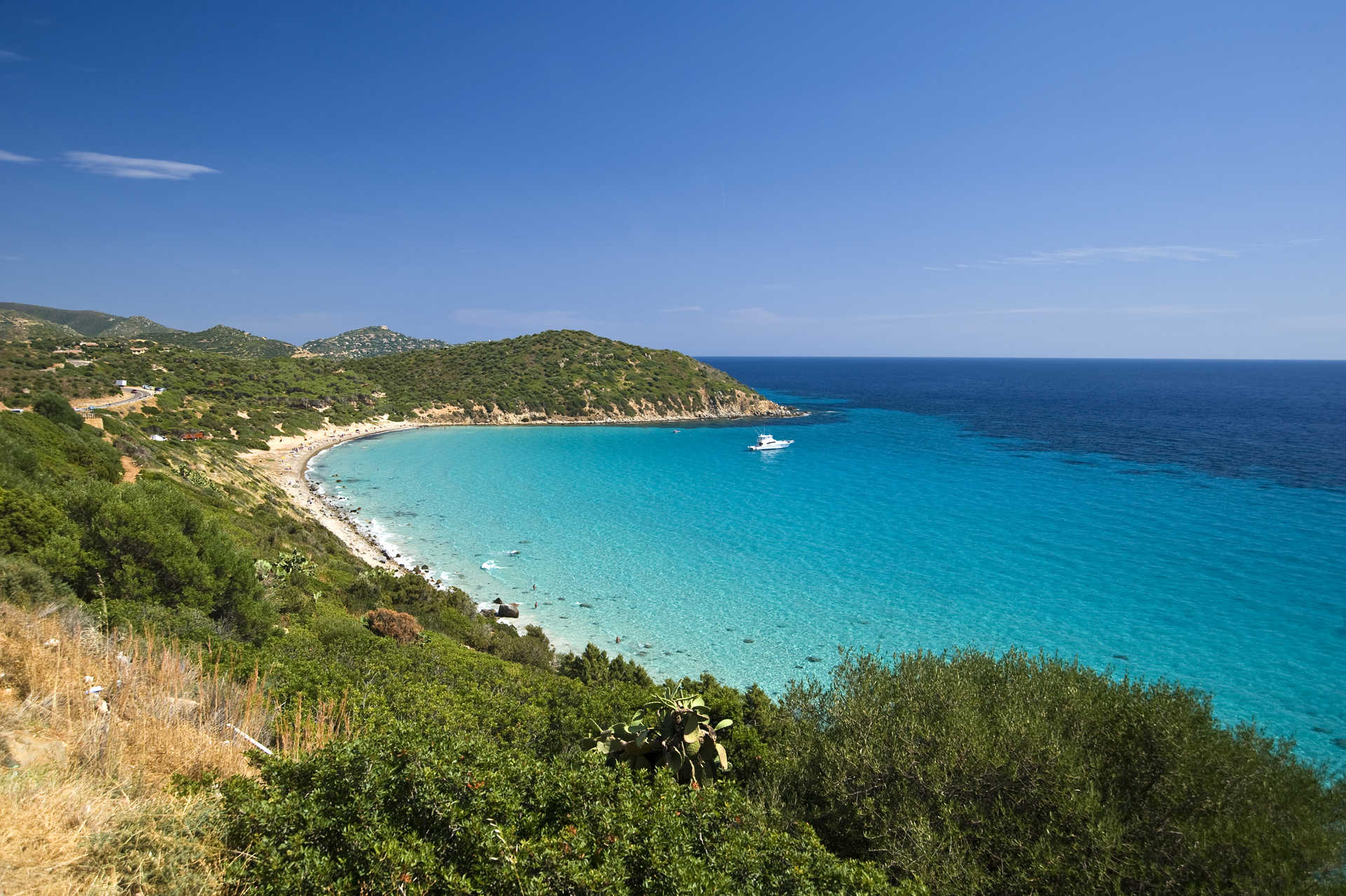
Cala Petra Ruja
It brings together the two ‘souls’ of the Costa Smeralda, as it is both glamorous and unspoilt at the same time: in fact, it is considered the ‘wildest’ beach of the symbolic location of high-end tourism on the Island. However, Petra Ruja, in the coastal territory of Arzachena, also has another distinctive feature, as its name, which means ‘red stone’, indicates: it is dotted with reddish-coloured rocks and granite pebbles. The beach, about 250 metres long, is in a bay with two promontories on its borders that determine its crescent shape. The sand is white and soft, while the transparent sea will surprise you with its shimmering colours, ranging from light blue to turquoise and glistening emerald green, typical of the Costa Smeralda.
On the subject of greenery, the entire bay is protected from behind by a crown of fragrant Mediterranean vegetation, where junipers, helichrysum, sea rushes and sea rocket stand out, as well as white sea daffodils. The islands of Mortorio and Soffi, which are almost ‘aligned’ in front of the beach, further embellish the landscape. To the east, you can see Porto Rotondo and the promontory of Punta Volpe.
The beach is suitable for families with children, as the waters are shallow, and it is also popular with snorkelling enthusiasts because of the transparency of its waters and the rocky outcrops, around which you can observe colourful fish fauna. Beyond the promontory, to the south, you’ll find a series of little coves that together make up the coastline known as Razza di Giunco. The name comes from giunchi, meaning rushes, which populate the marshy areas behind it, but its greatest charm comes from the myriads of islets, cliffs and pink granite fjords that draw a line of jagged coastline between the various inlets. On the opposite side, the largest beach of the Costa Smeralda awaits you: Liscia Ruja, 500 metres of white sand with golden and pink reflections - depending on the play of light -, is caressed by a crystal clear sea, with a turquoise colour among the most intense you will ever encounter. Plenty of services: bars and restaurants, beach equipment and boat rentals - canoes, kayaks and rubber dinghies - with which you can explore the numerous and captivating little coves scattered along the coast.
Three days in the southern seas
Ten minutes after landing in Sardinia, you will find yourself in the lively alleys of Cagliari’s historic districts. Glamorous boutiques and traditional shops, clubs, bars and restaurants where the best cuisine in Italy awaits you, according to the food and wine magazine, Gambero Rosso. The evenings continue at the beach bars along the ten kilometres of the city beach of Poetto, so close to the town centre and ideal for a dip in the sea on your day of arrival and departure. The itinerant short break along the coast of the golfo degli Angeli, returning to the city in the evening, is an ‘aperitif’ that precedes the picture postcard landscapes and beaches, while the journey of discovery of the southern seas is postponed to the following days.

Longonsardo tower
It is probably Gallura’s largest tower, most likely the most imposing one ever built on the island by the Spanish crown and is the symbol of Santa Teresa Gallura, together with the beach over which it watches. The Longonsardo tower stands on a promontory to the north-east of the town of Gallura, not far from where a castle once stood in the Middle Ages. It has a diameter of 19 metres at the base, some 16 in the upper cylindrical body, and a height of 11 metres. The building material used was, of course, granite, perhaps taken from the ruins of the manor. The tower was classified as de armas, or 'strong', built to house a garrison and heavy defence weapons.
It started appearing in documents in 1577, when it had become necessary to defend the harbour from attacks by Barbary pirates and the tower was built as part of a defensive strategy developed by King Filippo II, who instituted the “Royal administration of towers.” A surrounding wall was added, of which you can still see some remains, as well as a cistern for collecting rainwater. The entrance is six meters from the paved interior and will lead you to the fortified area, a domed room with a central pillar. On the right you’ll find the stairs that led to the parade ground.
The building was renovated towards the end of the 18th century when a domed crescent structure was built on the parade ground, with gun slits and rooms for the guards. At the northern end they put in a ravelin, a trapezoidal wall with barracks inside that included lodgings, ovens and a millstone. The tower was overtaken in 1802 when, led by a priest named Sanna Corda, a group of Sardinian and Corsican rioters conquered it. The occupation was short-lived and royal troops soon regained possession of it and captured the conspirators, all of whom ended up on the gallows. After the Royal administration of Towers was closed down, Longosardo was demilitarised although, for a short time during the Second World War, it was used to garrison a parachute regiment. Today it is open to visitors eager to learn about its fascinating history, and now and again it is used as a venue for gala and cultural events.
From its top at 40 metres above the sea, you will enjoy breathtaking views of Bocche di Bonifacio and the island of Corsica. If you look down to the left, you’ll be dazzled by the whiteness of Rena Bianca beach, Santa Teresa’s town beach. White sand with pink hues, the sea glittering with colours that span from blue to emerald green, and cliffs make this corner of Sardinia a must-visit on par with the gorgeous attractions of Capo Testa: the ‘twin’ beaches Rena di Ponente and Rena di Levante, Cala Spinosa and Cala Grande - Valle della Luna. Three kilometres to the south-west you can journey back in time to the Nuragic age of Lu Brandali. Nestled in Mediterranean brush, it is a fascinating complex with a nuraghe, village and Giants’ tomb.
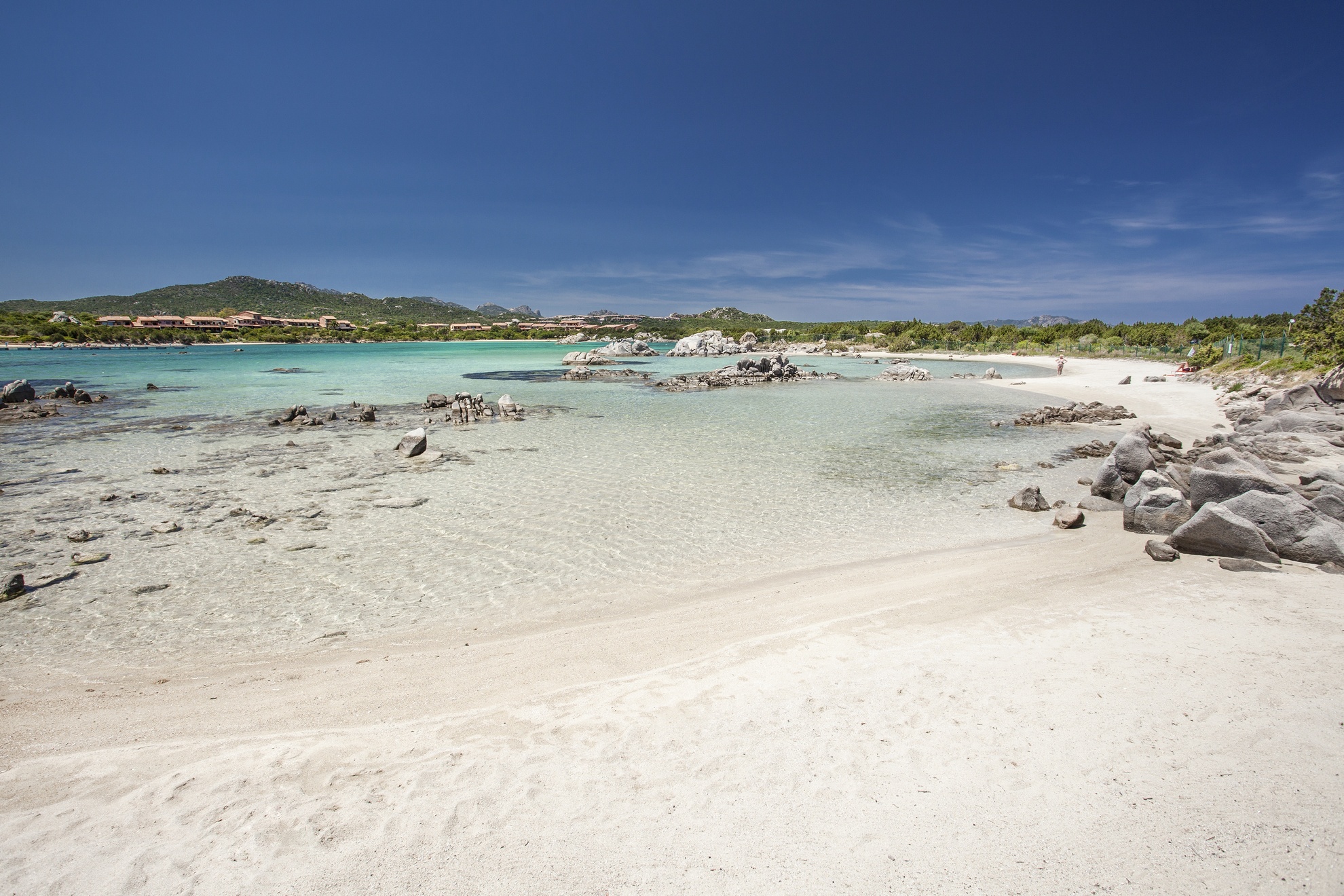
Baia de Bahas
They are often called ‘pools’, because of the unreal transparency of the water, though they are really coves that open up in succession along the eastern side of the Gulf of Marinella. The small beaches, positioned in an arch shape, form the de Bahas Bay, five kilometres to the west of Golfo Aranci in the direction of Porto Rotondo. You will be struck by the soft, medium-grained amber-coloured sand and the emerald green colours of the sea, also the result of the reflection of sun’s rays on the ‘carpet’ of Mediterranean vegetation all around. White rocks emerging from the water and granite rocks dotted across the beach and delimiting the borders of the various coves complete the picture.
On the left-hand side, there is a tourist port with a pier. It is the only ‘artificial’ aspect of the bay, which is otherwise completely free and unspoilt, making it an ideal place for a total immersion in nature. The shallow waters and shelter from the winds make it suitable for families with children, while diving and snorkelling enthusiasts will appreciate the rich plant life and fish fauna, especially on the eastern side and around the rocks. The panorama in front is enhanced by the view of the Islands of Soffi and Mortorio in the distance.
The southwestern corner of the Gulf of Marinella is occupied by the beach of the same name, which, unlike those of Bahas, extends uninterruptedly for more than a kilometre and is characterised by white sand. It shares the colour of the sea and the shallow waters with the bay. You will find various services here: parking, refreshment areas, beach equipment rentals and even a windsurfing school. Behind the beach, on the right side, stands the small seaside village of Marinella, equipped with a tourist port. Between the Bay of Bahas and Marinella, Punta Marana juts out into the sea and is a promontory dotted with coves and inlets, including the crescent-shaped beach of Cala Marana.
Golfo Aranci has 24 beaches, all worth visiting, starting from the Five ‘City’ Beaches and proceeding towards Olbia, with the enchanting and well-equipped Spiaggia Bianca (White Beach) and Cala Sassari, as far as Sos Aranzos, ‘tinged’ with the white of the granite rocks and the turquoise colour of the sea. In Capo Figari, which is rich in historical evidence, the jewels are Cala Moresca, Cala Greca and Cala del Sonno, while a little further east of the Gulf of Marinella, the picture-postcard landscape of Cala Sabina awaits you. It can also be reached by train and is ideal for exciting diving and nature walks in the surroundings.
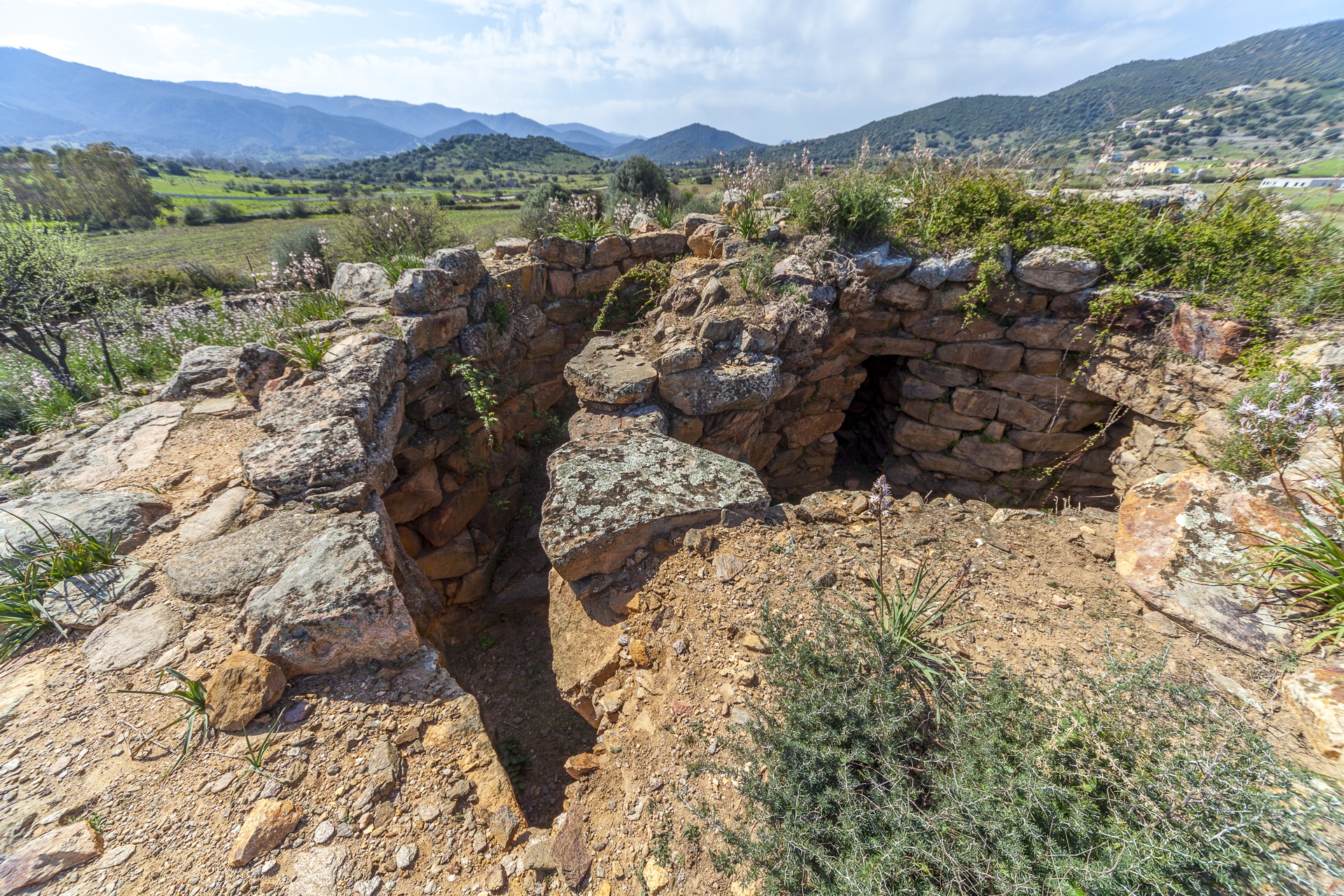
Nuraghe San Pietro - Torpè
It was most probably created on a previous Pre-Nuragic building, after which, for almost two thousand years, Nuragic and Ancient Roman populations gravitated around it, inhabiting a fertile plain crossed by the Posada river, which is now part of the Oasis of Tepilora area. The nuraghe San Pietro stands in the locality of the same name, three kilometres from Torpè, a few hundred metres from the river bed. It is a quatrefoiled building, with a central keep - perhaps older than the rest of the building – constructed using large blocks of trachyte, positioned in rows with the addition of shims. The lateral towers, on the other hand, were built using schist blocks. The main tower has a rectangular entrance, over which there is a flat arch, and it is south-facing. The external diameter is approximately 14 metres. Inside, you will see a sentry box and a spiral staircase leading to the terrace. Moving along the corridor, you will come to the central chamber, with three niches positioned in the form of a cross.
The building has an irregularly shaped courtyard, inside which you will notice a funnel-shaped well. During the last excavation campaign, a circular room emerged next to the keep: at the base, along the circumference, runs a counter on which a large number of objects were found, including pots, bowls and pans, evidence of the trading that took place on the site. In the centre of the room, there is a hearth, with rounded stones around the edges. The south-west tower has recovered the most evidence of the long period during which the site was frequented and, in fact, the finds range from the Early Bronze Age – particularly linked to the Bonnannaro culture, between the 19th and 17th centuries BC –, to the Imperial Age, up to the 4th-5th century AD. It is the only tower of the nuraghe that shows traces of Roman occupation: around the 2nd century AD, it was used as a granary, but broad beans, wood and cork were also stored there. Fifty metres south of the fortress, you can see traces of other buildings. It is a building complex originally made up of Nuragic huts, later reused in Roman times and, in turn, a quadrangular construction, perhaps medieval, was built on top of it.
The Torpè territory combines archaeology with nature: in fact, part of it falls within the Regional Park of the Oasis of Tepilora that, with its almost eight thousand hectares, contains a myriad of different landscapes, including granite plateaus, forests, ponds, springs and waterways. Inside it, you can enjoy numerous outdoor activities, including trekking, mountain bike excursions and kayaking along the Posada river.
Sa Domu 'e s'Orcu - Domusnovas
According to popular beliefs, the ‘houses of the ogres’ were inhabited by evil creatures and demonic spirits. Rumours that may have already been around in the early Christian era, to highlight the pagan aspect of the people who built them, are still useful for preventing children from venturing inside them today. The name is recurrent in several Domus de Janas – in Setzu and Siliqua -, in Giants’ Tombs, like the majestic tomb of Giara di Siddi, and in various nuraghi, including the one located just outside the village of Domusnovas. Sa Domu’e s’Orcu domusnovese is characterised by a large number of towers - nine, including the keep -, and by its position, at the foot of Mount Mannu, between the Marganai mountain chain and the Cixerri river plain. It is a complex nuraghe, with a central tower surrounded by a trilobate bastion, which encloses the courtyard, around which a rampart runs with five other towers. Limestone from the Marganai massif was used to build the monument.
Four and a half metres of the keep have been preserved, while the bastion is 17 metres long and its best-preserved parts reach a height of seven metres. In the external curtain wall you will notice the use of larger ashlars, positioned in rows that are more even than the rest of the building: it was most likely added at a later time. Therefore, the building must have been built in several phases: it is thought between the 17th and 11th centuries BC. In the corridor providing access to the room with an elliptical layout, on the right, there is a spiral staircase leading to the upper level.
One of the towers on the rampart contains a semicircular cell. Traces of the use of fire have been found on the walls of this cell. Smelting slag appears in some of the rooms in the courtyard and in the area around the building, near the remains of structures that have been interpreted as belonging to the village. These traces of metal processing most likely refer to the exploitation of the Marganai, deposits, where the mines remained active until the second half of the 20th century.
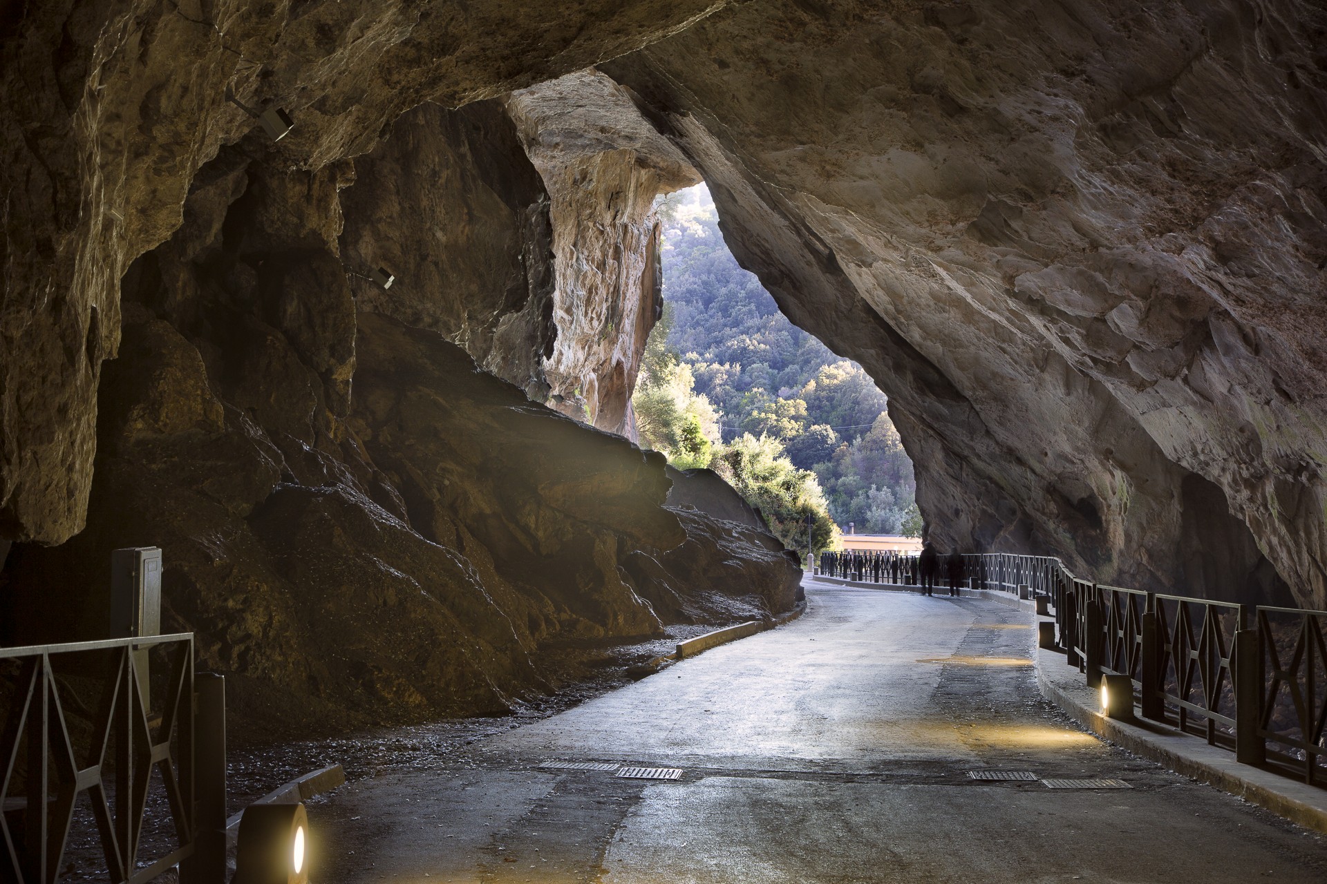
Just over two kilometres from the nuraghe, you can admire one of the longest natural tunnels in Europe, one of the very few to be crossed by a road: it is the cave of San Giovanni. It was carved out of the limestone by an underground river and, thanks to the lighting system, you will be able to admire its walls, which are rich in stalactites and stalagmites. All around, there are very ancient rocks - dating back to the early Palaeozoic era, 500 million years ago - and sheer cliffs, representing a destination for climbers from all over the world. Then, to the north, numerous paths branch out through the woods and next to abandoned mining sites in the Monte Linas-Oridda-Marganai park.

Archaeological park of Noddule
The first to appear are mysterious megalithic circles and then, almost in chronological order, there are other structures: the nuraghe emerges on top of a rocky outcrop; not far away, there are the surviving traces of a Giants’ Tomb and, lastly, the sacred area, with a spring that has a surprising feature. The Nuragic complex of Nòddule is located in the territory of Nuoro in the locality of su Linnamene, on the border of the Orune territory, in an area covered in granite rocks and cork oaks. The site was frequented from the 3rd millennium BC until Roman times, perhaps with a few sporadic periods of abandonment. Evidence of the pre-Nuragic phase are found in the megalithic walls and in two circles, made up of large granite rocks slightly spaced apart, the function of which is uncertain. It has been suggested that they represent a sort of prehistoric ‘calendar’, with the stones positioned according to the movement of the stars. When entering the complex, you will be ‘leaping’ forward in time as you explore the Nuragic monuments.
The nuraghe is a complex, trefoil one, surrounded by walls. You can enter the keep from the southern entrance, which leads to a corridor equipped with a bartizan. Just over four metres of the tower has been preserved and it has a diameter of about eight metres. A courtyard connects the two secondary towers. Next to the towers you will see traces of rectangular rooms: they were built with materials resulting from the collapse of the nuraghe in Roman or early medieval times. Then, around the nuraghe, you’ll see six Nuragic huts, the largest of which has a hearth in the centre.
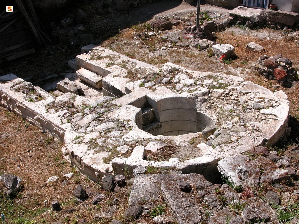
The sacred area is located inside an enclosure containing several circular spaces and a spring. The well temple consists of a quadrangular vestibule with bench-seats and a cylindrical well that collected the water. Trachyte ashlars were used to create it and were positioned in even rows in the well, on the façade and in the tholos roof, where you will be amazed by the variety of colours in the ashlars and the decoration of the stone closing the building, with an eye-shaped hollow, almost as if the spring wanted to ‘observe’ its visitors. Beyond the settlement, but pertaining to it, you will see traces of a small Giants’ Tomb. It was built in rows, with large, well-squared granite ashlars. Many of them have been removed, but you can still identify the layout and the base rows of the funeral chamber and the exedra.
Predio Canopoli
It is one of the most refined examples of architecture linked to the worship of the waters from the Nuragic age, with incredibly precise measurements and geometries. The sacred well of Predio Canopoli is found in Perfugas, right in the town centre, and was discovered in 1924 by the owner of the land, from which the well got its name. The building is entirely made from limestone ashlars, probably from the Laerru quarries and worked with extreme care: there are no mortars or binders and the stones are laid dry, in blocks inserted with incredible precision, forming two walls connected by T-shaped or dovetailed ashlars. The building and installation of the blocks made using the opus isodomum technique bring to mind those of the well at the Sanctuary of Santa Cristina in Paulilatino. The hypogeic chamber has a truncated cone shape, it is paved and perfectly circular and has well-smoothed walls. The ceiling, which is missing, must have been a tholos (false dome) type. The room is preceded by a rectangular vestibule, which is also paved, with bench-seats, at the end of which there is a staircase with eight steps leading to the spring.
You will also notice that the ashlars of the thlobate of the well and the vestibule are bossages on the external side, with two protrusions per block: it is not clear whether this choice is aesthetic, symbolic - representing the horns of the bull - or simply practical, as the bossages would make it easier to handle and transport the ashlars. Around the area, there are traces of a fence made of trachyte blocks, built on the remains of a temple in antis. You will also see the remains of structures probably linked to the huts of a village. The dating of the temple is uncertain: some place it in the Middle Bronze Age (16th-14th century BC) and others suggest a later date, between the Recent and Final Bronze Age (13th-9th BC). The finds unearthed during the excavations have demonstrated that the site was frequented until the Middle Ages and a bronze votive offering, depicting a bull, stands out. The artefact, on display at the G. A. Sanna National Museum in Sassari, is considered one of the most elegant portrayals of bovines ever found in Sardinia. You can admire most of the findings from the well by visiting the Archaeological Palaeobotanical Museum of Perfugas, where there is an exhibition covering a period of time from the most ancient stone artefacts found so far on the Island - dating back to the Palaeolithic period - to medieval majolica from the churches around the Anglona village. On the subject of places of worship, a visit to the Parish Church of Santa Maria degli Angeli in Perfugas, right in front of the Predio Canopoli, is a must: the church contains the largest retable in Sardinia, dedicated to San Giorgio and created at the end of the 16th century. It is the work of an anonymous artist known as the Maestro of Perfugas.