

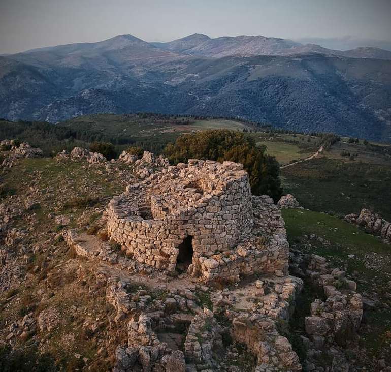
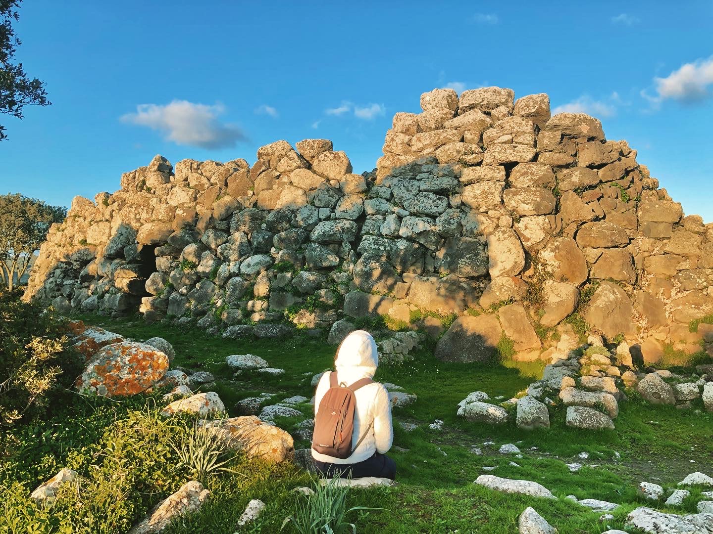
Nuraghe Orolio
Its granite tower is twelve metres high and has two overlapping chambers that, quite exceptionally, still have their tholos roofs intact and an unusual, elaborate system of steps. The nuraghe Orolio, also known as Madrone, stands at a height of over 400 metres above sea level on a hill to the north-east of Silanus, about a kilometre from the village in the Marghine territory. It was originally a complex nuraghe, probably trefoil, but today only the truncated cone-shaped keep is still in excellent condition. You can enter the building from an entrance on top of which there is a mighty architrave and then a corridor will take you to the first room. Here, you will notice three niches, one facing the entrance and the other two positioned crosswise, creating a cross. The stairwell starts on the left, leading to the main room located on the second level. As in the space below, you can admire the tholos, still intact, despite the traces of a collapse in the wall surface, two niches and a further opening, perhaps a window, an unusual architectural element in a nuraghe. A further stairwell, overlapping the previous one, seems to lead to a mezzanine floor, the function of which is still unknown. The keep also had a third level, of which a single row of perimeter ashlars still remains. Around the tower you will notice the remains of other structures, still to be investigated, among which there are most probably the village huts.
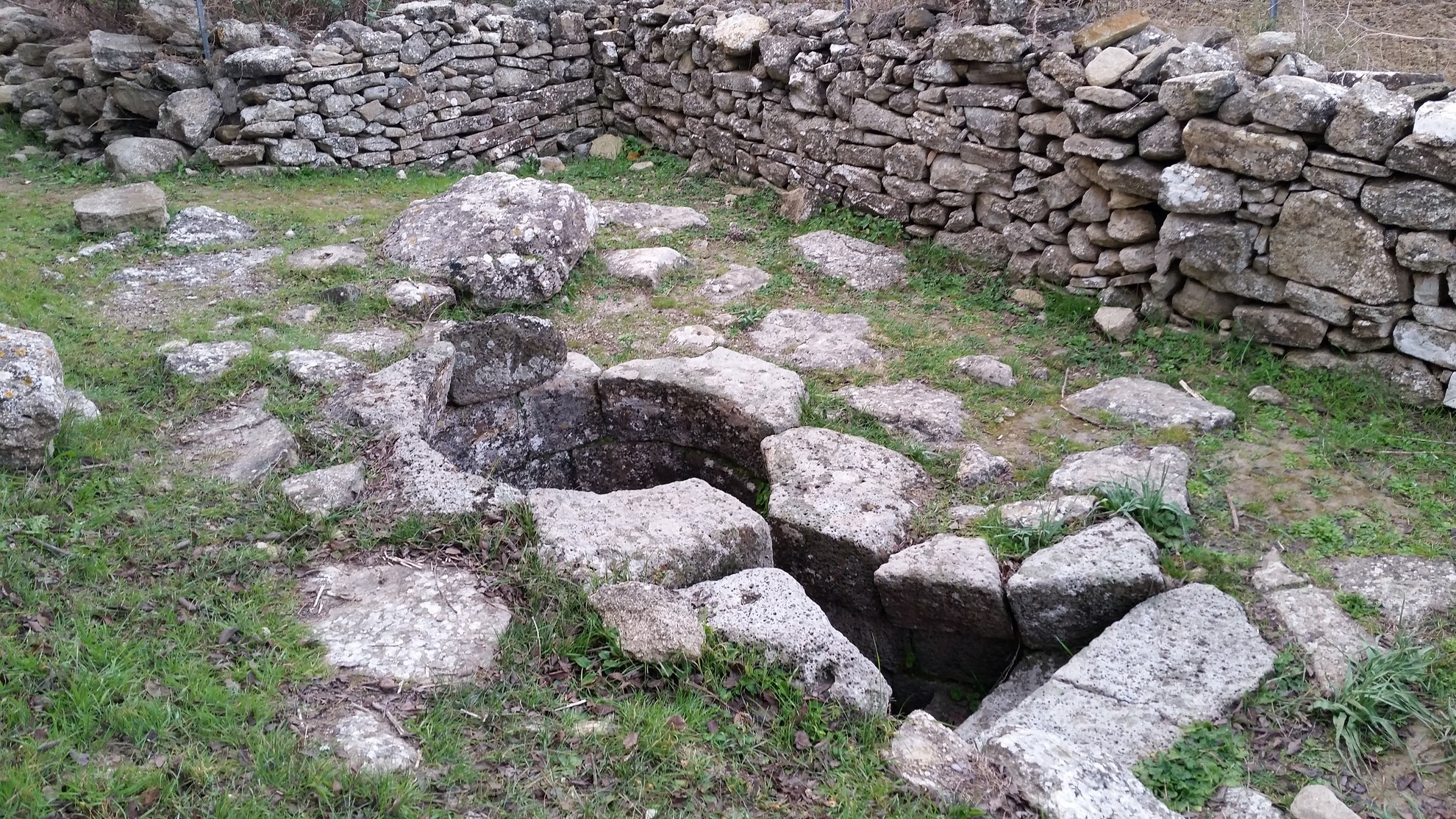
The territory of Silanus is an open-air archaeological museum: in addition to the Orolio, there is also the single-tower Corbos, also in excellent condition, the nuraghe s’Ulivera – perhaps originally corridor type -, and the Tombs of Giants of Pedra Longa, Pedras Doladas, Zanchia and Murartu. The complex of Santa Sabina stands out for its beauty and distinctiveness, set in the rural landscape: next to a single-tower nuraghe, around in which a large village of huts developed, there is a very ancient church of early Christian or Byzantine origin. The prehistoric evidence also includes two Tombs of Giants and the sacred well of su Cherchizzu, one of the smallest discovered so far in Sardinia. The church was built by taking materials from the nuraghe - as can be deduced by the similar colours of the two monuments - and has an unusual layout, with a domed and apsidal cylindrical body onto which two lateral rectangular chambers are attached, with a sloping roof. A short distance away, there is a row of cumbessias, typical stone lodgings used since their construction to accommodate pilgrims and novena pilgrims. Every year, on the occasion of the feast of Santa Sabina, they come alive with evocative rituals, songs, prayers and delicious banquets.
Nuraghe Ardasai
You will see it almost suddenly, on the top of a rocky spur along a spectacular scenic road with a view of hills and green valleys. Its position and setting will captivate you and you will be intrigued by a mysterious path. The nuraghe Ardasai is located on the slopes of Tonneri, about 13 kilometres from the residential area of Seui. A strategic position, from which the access roads to Barbagia can be controlled. The structure is part of a complex that also includes a village, the remains of a Giants’ Tomb and perhaps a sacred well.
This is a single-tower nuraghe, probably built during the Middle Bronze Age (17th-14th century BC) with large limestone blocks, originally on several levels. Today, the lower floor still remains, with a tholos vault and a spiral staircase that led to the second level. Around the tower, there was a curtain wall with secondary towers, traces of which can still be identified.
The village huts were positioned around the nuraghe and were oval or circular in shape. In some cases, they exploited the natural form of the rock. Further traces of settlements are scattered over the surrounding hills and downstream: the fortified Nuragic village of Serra su Casteddu occupies the top of the mountain that stands in front of the nuraghe Ardasai, on the opposite side of the road, while all around, within a radius of a few hundred metres, there are other nuraghi, tombs, villages and megalithic circles.
The Ardasai is the subject of a legend that links it to the fortress of Monte Baranta in Olmedo, with which it also shares the position on a sheer rocky spike: a paved path starts from the south-west side of the tower and apparently ends in a sort of natural gateway, delimited by two limestone boulders. Beyond, you’ll find the edge of a ravine. At Monte Baranta and in the surroundings of Gairo Vecchio, there seem to be similar paths, which legends and local traditions apparently identify with the places where the ritual sacrifices of the village elders were celebrated in ancient times.
The territory of Seui is ideal for combining archaeology and trekking through nature: on the opposite side of Monte Tonneri, in an easterly direction, you can admire the unmistakable outline of Perda ‘e Liana, a natural monument and the symbol of Ogliastra. Then, a little further south, lies the forest of Montarbu, one of the most captivating in Sardinia thanks to its landscape and wildlife heritage. You can also cross it in an original way, aboard the Trenino Verde tourist train.
Sacred well of Coni
The image that comes to mind as you observe it is that of an archaic stone lock, obtained from the rock, who knows how, also considering the absence of a construction element typical of similar structures built in Sardinia. The precision and care with which the well temple of Coni was built is ‘living’ evidence of the importance of the worship of the waters among the Nuragic people. It was built in the locality of the same name on the slopes of the Valenza hill, just over a kilometre from Nuragus, in a ‘sacred’ area where thousands of years of traces ranging from the Bronze Age to the Middle Ages coexist. Basalt blocks were utilised using the opus technique for the construction of the sacred well.
A staircase, protected by a corridor, leads down to the underground chamber, where the vein of spring water flows. You’ll notice the absence of a vestibule, an element generally present in sacred Nuragic wells: it isn’t clear whether it was intentionally omitted or whether it was entirely demolished in order to use the materials in later periods. The stairwell has a trapezoidal layout, while the room is circular and originally had a classic tholos roof. Today, you can see five rows of protruding ashlars, carefully shaped, and the foundation ring. A bronze artefact was found here, depicting a female character in the act of prayer and was therefore called the ‘praying matriarch’, currently on display at the National Archaeological Museum of Cagliari.
A few hundred metres from the sacred well, you will see a tower built with limestone blocks, about six metres high: it is what remains of the Santu Millanu complex nuraghe. Originally multifoil, there are still traces of the bastion and four corner towers around the keep. Once through the entrance, which is partially below ground, you will enter a small cell, which in turn leads to the corridor. From here, you come to the central room, with a circular layout and three niches positioned in a cross pattern. In one of these, there is the stairwell, which led to a secondary room and probably continued to the second level. You’ll notice some holes on the walls: beams supporting a wooden mezzanine were probably attached there.
It is suggested that the area around the nuraghe and the well witnessed the emergence of the Roman and medieval village of Valenza, mentioned by Pliny the Elder and Ptolemy. One of the pieces of evidence supporting the thesis are the ruins of a medieval church dedicated to Santa Maria in Valenza. You can identify its layout, with a single nave, and the outline of the apse. Its most precious treasure has been lost: a milestone bearing witness to the restoration work performed on the Roman Road of Karalibus Ulbiam, which linked Cagliari and Olbia in the Imperial Age, demonstrating the importance of the site of one of the main Roman viae on the Island.
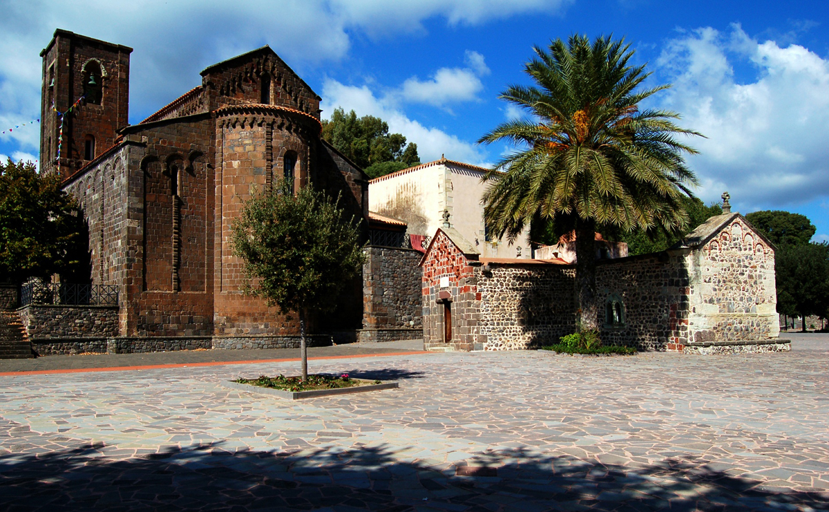
Santa Maria di Bonarcado
Its origin is referred to in one of the oldest documents written in Sardinian language, the story of its construction is true evolution over time and its present is that of one of the most captivating examples of Romanesque style on the island. The church of Santa Maria, parish church of Bonarcado, raised to the rank of minor basilica in 2011, stands in front of the early medieval sanctuary of Nostra Signora di Bonacatu, one of the very first Christian churches in Sardinia, as well as the site of the oldest documented Marian cult in the region.
The sources, particularly the condaghe of Santa Maria di Bonarcado, trace the beginning of its history back to around 1100, when the judge of Arborea, Constantine I, decided to found a Camaldolese monastery near the pre-existing little church. A few decades later, the same monks began to build the clesia nova, because the first one was too small to meet the needs of the community. The first building had a tau cross layout, with a single nave and dark basalt and reddish trachyte ashlars were used as building materials. In 1242, as demonstrated by an inscription that you can see on a pilaster in the left-hand corner of the apse, extension work began, perhaps by Iberian workers: the apse and the north wing of the transept were demolished, the length of the hall was doubled with the addition of a three-nave body, while the bell tower was set up in the south wing.
Today, you can admire several elements dating back to the 12th century: the façade with three blind arches, with an architraved portal in the central one, and the right side, including the first order of the bell tower, decorated with a series of small arches on corbels. Above the small arches that decorate the external walls of the ‘new’ part of the central nave and the apse, there is an arabesque foil - probably resulting from the place of origin of the workers. Inside, the roof over the naves is wooden and they are separated by arches resting on quadrangular pillars. The light is soft, coming from the single lancet windows of the apse and the pediment. Walking along the left side of the basilica, you will see the remains of the Camaldolese monastery that, among its properties, included cultivated land, vineyards, woods, pastures and fishing areas, between the Campidano di Milis area and areas of Mandrolisai. In the area where the two churches stand, traces of very ancient human presence have been recovered: there once stood a Nuragic settlement, on which a Roman village was built. The church of Nostra Signora di Bonacatu was built on the ruins of a late imperial spa building, a Greek cross plan sanctuary with a domed body at the point of intersection of the wings, an apse in the north wing and two façades: one Romanesque, with unusual inserts of ceramic bowls, and one built in the 20th century in neo-Romanesque style.

Santa Maria di Contra
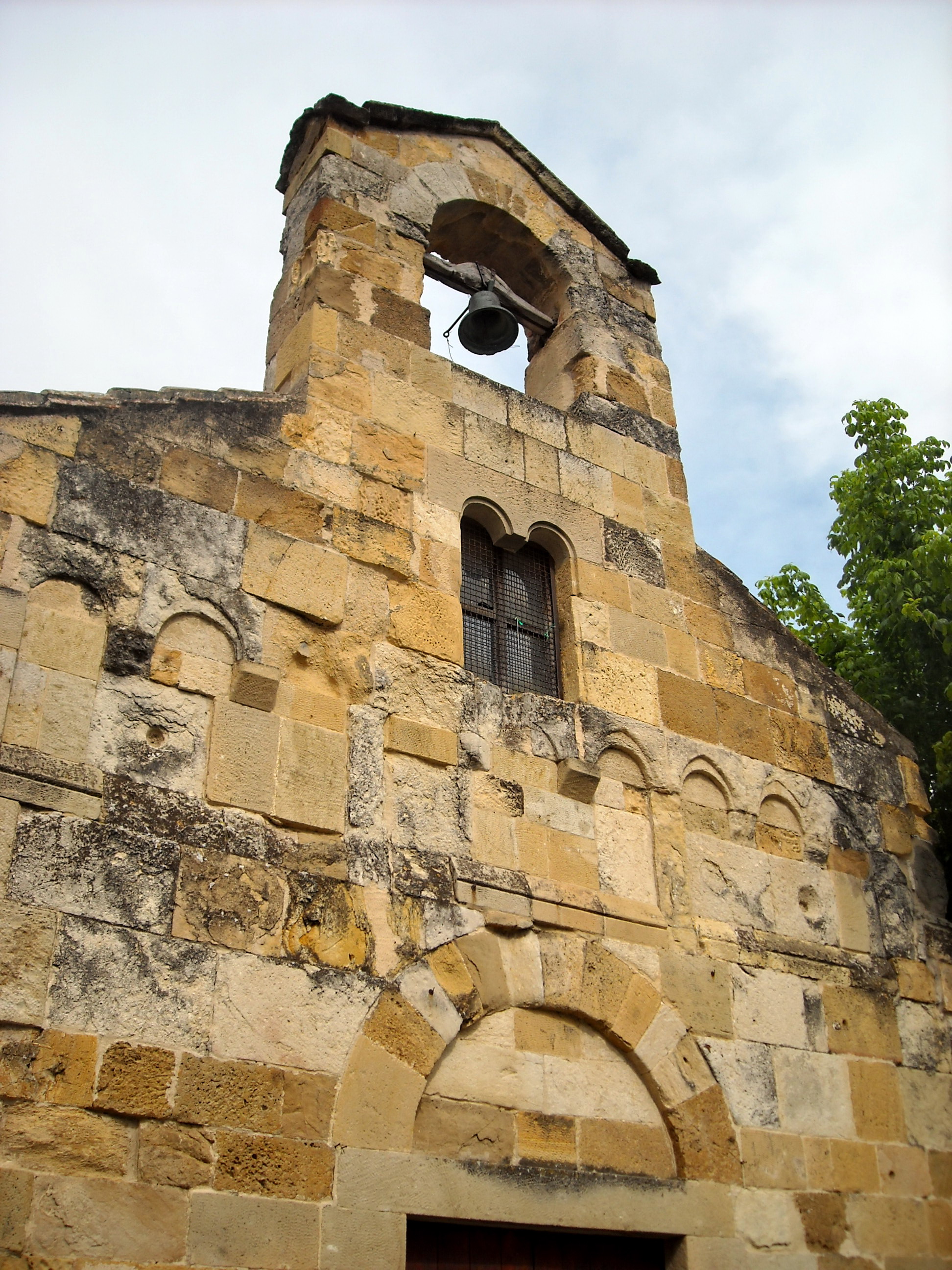
It is one of the smallest Romanesque churches in Sardinia and has been resting for nine centuries in the open countryside, surrounded by cultivated fields, olive groves and orchards, less than a kilometre from the town of Cargeghe. It is documented, from 1125, as one of the properties of the monastery of San Salvatore di Camaldoli, under the direct control of the Basilica of the Santissima Trinità di Saccargia, but the Church of Santa Maria di Contra was probably built by workers active in the nearby curatorie (administrative divisions) of Ploaghe and Goceano. The building material used was limestone, worked in medium-sized regular-shaped slabs.
The façade, above which there is a bell gable, features a portal with monolithic jambs and a raised relieving arch. You will also notice a cross-shaped window – repeated on the back, above the apse - and two corbels, which probably served as support for a portico or a roof, which is no longer there. Other windows, with ogival and double conch centring, appear in the apse and on the sides. Another room similar to a loggia was built on the north side at a later date and was used to welcome pilgrims. Inside, the church hall has a single nave, which is simple and austere, and contains an antependium dating back to the 17th century. As per tradition, the apse is facing east, towards the rising sun. Santa Maria di Contra is also known for a peculiarity: it was one of the locations used during the filming of ‘Padre Padrone’, a film released in 1977 and based on the novel of the same name by Gavino Ledda.
The surrounding area is full of architectural and archaeological treasures. On the subject of medieval churches, eight kilometres from Contra, you can admire one of the absolute masterpieces of Sardinian Romanesque style: the Basilica of the Santissima Trinità di Saccargia, in the territory of Codrongianos. You can see the very tall bell tower from afar, but when in its presence you will be struck by the solemnity of the building and the charm of the two-coloured lines. Between Cargeghe and Florinas, at the foot of the Giorré plateau, lies the necropolis of s’Elighe Entosu, consisting of five Domus de Janas dug into isolated blocks of limestone rock. Two of them, Tombs 1 and 4, are distinguished by raised architectural elements and symbols, particularly spiral motifs, doors with bas-relief ledges above them, pilasters, false doors and grooves on the ceiling, imitating a double-pitched roof. Particularly captivating, on the eastern outskirts of Cargeghe, is a piece of evidence dating back to the 2nd century BC: the Roman road of sos Bajolos that you can also travel along at night, thanks to a lighting system.
San Leonardo - Masullas
Its foundations tell a story, which is older than what you see at first glance, made of legends, abandonments and the ‘secular’ reuse of it. The Church of San Leonardo is the oldest place of worship in Masullas, a municipality in the Alta Marmilla area, in a scenic position at the foot of Monte Arci. There are no documents attesting to the building and consecration of the church, but its construction features have led to the theory that it dates back to around the mid-13th century. During a recent renovation phase, the foundations of a pre-existing place of worship, perhaps from the Byzantine era, were discovered. The current building was constructed on top of the previous one, respecting its structure and orientation: a longitudinal layout, with a single nave and a semicircular apse facing north-east. Sandstone and trachyte blocks were used for its construction. You can see them on the façade, decorated with small false loggias, where a mullioned window and a large bell gable stand out, as well as the entrance portal – along the same axis – with a monolithic architrave and a relieving arch.
The church hall has a wooden roof, capitals with plant decorations on the south wall and the image of a face carved into the centring of a single-lancet window in the apse. You will feel like you are in an intimate and cosy environment, also thanks to the simplicity of the furnishings. According to local tradition, the church contains the tombs of two martyrs, one of whom is Saint Callixtus, a pontiff in the first decades of the 3rd century. The origin of this legend lies in the fact that the church was part of the possessions of the then flourishing Vallombrosian Abbey of Thamis, the ruins of which are now located in the territory of Uras. The monastic order was in close contact with the German abbey of Fulda, to which the martyr’s remains, or at least part of them, were apparently transferred. Thanks to the cult of relics venerated by the Vallombrosian monks and the close relationship between the two abbeys, Saint Callixtus's remains finally reached the church, where some say that two sarcophagi were embedded in the walls. The church then went through a phase of abandonment and use as a monte granatico (wheat bank), after which it underwent initial restoration work in 1859.
The journey from the Middle Ages in Masullas to the Savoy period continues with a visit to the nearby museum of ‘I CavalierI delle Colline’ (Knights of the Hills), with an exhibition that focuses on the rural aristocracy of the ancient curatoria (administrative division) of Parte Montis, which the village of Masullas belonged to. Also not to be missed is the GeoMuseo located inside the former Capuchin convent. Among the fossils, agates, crystals and volcanic rocks, the ‘black gold’ of Monte Arci stands out, which was traded as early as the Neolithic period: in fact, the Conca ‘e Cannas obsidian park, the largest deposit cultivated in the Nuragic era, falls within the territory of Masullas. The surroundings lend themselves to fascinating excursions in nature: you can walk through the Taraxi forest and admire the rock face of su Columbariu, the pillow (underwater lava outcrop) of su Carongiu de Fanari and sa Perda Sperrada, a mass of rock almost perfectly split in half.
Sa Fogaia park
A very ancient nuraghe, ‘from the very beginning’, with unique shapes, and a prehistoric village with a station where obsidian was processed along with a ‘garden’ of great environmental value around it. These are the elements that characterise the park of sa Fogaia, inviting you to visit it. It is a green oasis that covers the eastern slope of the Giara di Siddi, just over a kilometre away from the beautiful village of Marmilla. The ‘upper’part of the park is the scenic area, where you will have a view of the Marmilla hills and the Giare of Gesturi and Serri, as far as the view of the Gennargentu massif. In a strategic position, on the edge of a precipice, you will find the corridor-type nuraghe of sa Fogaia. It was built over 300 metres above sea level on the rocky outcrop, using dry and overlapping interlocking blocks of basalt.
The building shows traces of various construction phases: the nucleus is represented by the ‘protonuraghe’, i.e. the archaic version of the famous construction, with an unusual ‘Y-shape’ layout. It is thought that its origin dates back to the beginning of the Middle Bronze Age and, later on, two other megalithic bodies were added alongside it, as well and a series of secondary spaces. To enter, you can go up a stepped ramp carved into the thickness of the wall: the entrance is in fact raised five metres above the walking surface. In the inner corridor, you will notice more steps, which once led to a terrace that is no longer there. Parts of the roof of the two adjoining buildings have survived and were made in different styles: jack arch, tholos (false dome) and ogival. In several rectangular rooms in the internal courtyard, there have been finds dating back to the Late Punic and Roman periods. Around the nuraghe, you will notice traces of a village where obsidian was found, proof that there was a stone workshop in sa Fogaia dedicated to working on the ‘black gold’ from Monte Arci.
The archaeological theme is not the park’s only element of charm: living in the holm oak woods and Mediterranean scrub, there are more than 150 different plant species as well as a wealth of wildlife. You can stroll surrounded by the colours and scents of wild orchids and numerous aromatic and medicinal plants. One path in particular, known as su mori ‘e is erbas (the path of herbs), which was once an old mule track used over the centuries by the community of Siddi, will accompany you as you observe the most typical floral species of Marmilla, described on special wooden signposts. Among the park’s ‘residents’, there are about 60 types of bird, such as the barn owl, the owl, the raven, the kestrel and the lapwing; you might also spot weasels, hares, foxes and various species of reptile.
Continuing in the northwesterly direction, you can enter the Giara di Siddi, in which there is one of the largest and best-preserved Tombs of Giants in Sardinia: sa Dom’e s’Orku that, just like the nuraghe Sa Fogaia, was built using large blocks of basalt between the Early and Middle Bronze Ages.
Monte Urpinu
One of the oldest and largest green lungs of Cagliari is home to a variety of picturesque local characters and historically significant buildings. Mount Urpinu park spreads out over 22 hectares on its eponymous hill between the Molentargius-Saline natural park and the Bonaria hills. It owes its name to a now-extinct colony of foxes that populated it until a few centuries ago, when it was still covered in wild vegetation. In fact, Urpinu means “little fox” in Campidanese. Monte Urpinu was also the site of some small military forts until it was bought by the aristocratic Sanjust family. The new owners first had it reforested, planting numerous Aleppo pines, and then restored a small church, now known as the Aragonese Church, originally built between the 17th and 18th centuries over the remains of a small Byzantine sanctuary.
In 1939, Monte Urpinu became the permanent property of the City of Cagliari. It was soon turned into an urban park, although the side that looks out over the Molentargius swamp remained at the disposal of the Italian air force, who constructed a base and some underground fuel storage tanks there. Another area of the hill was used as a limestone quarry. In 2007, the military abandoned its base, and several decades before that the park underwent a further reforestation project.
It is now one of the favourite outdoor leisure spots of local residents. Here you can walk along a series of paths or go for a good run. There is also exercise machinery and a popular tennis club. Families take their children to the park to enjoy the spacious equipped playground. Picnics can be organised in the shade of trees and next to some artificial lakes. There are even two hectares dedicated entirely to dogs. And speaking of animals, the local fauna is also one of the park’s attractions. There are swans, moorhens, mallards, geese, tree frogs, turtles and colourful peacocks. The park is also home to a colony of cats. Equally interesting is the flora: in addition to the pines, you will spot willow trees, oleanders, junipers, and holm oak, mastic and olive trees.
The eastern flank of the hill has a panoramic road from which you can enjoy gorgeous views on both sides: from the Belvedere you’ll see the spectacular Golfo degli Angeli (Gulf of Angels), spot the Sella del Diavolo (Devil’s Saddle), Molentargius and its salt flats, and the Poetto beach. On the other side, looking west, you’ll see San Michele hill, crowned with its medieval castle, the historical districts of Villanova, Castello and Marina, the harbour and the Stagno di Cagliari (Cagliari Pond).
Monte Claro
The walls embrace a large garden where nature, history, culture and wellness reign. Monte Claro park sits on the summit of the eponymous hill, in the centre of Cagliari, a short distance from another of the seven hills on which the capital was built, San Michele hill. This park spreads out over 25 hectares delineated by walls that once encircled an old psychiatric hospital. In the late 19th century, the Province of Cagliari rented the area to house the unwell, and over time it became the pavilions of the hospital. All around were orchards, vineyards and crop fields where sometimes even the patients worked. The hospital was shut down in 1998 and the entire area was repurposed as a city park, opening in 2001. The main building, Villa Clara, where the hospital’s director once lived, is now the metropolitan library.
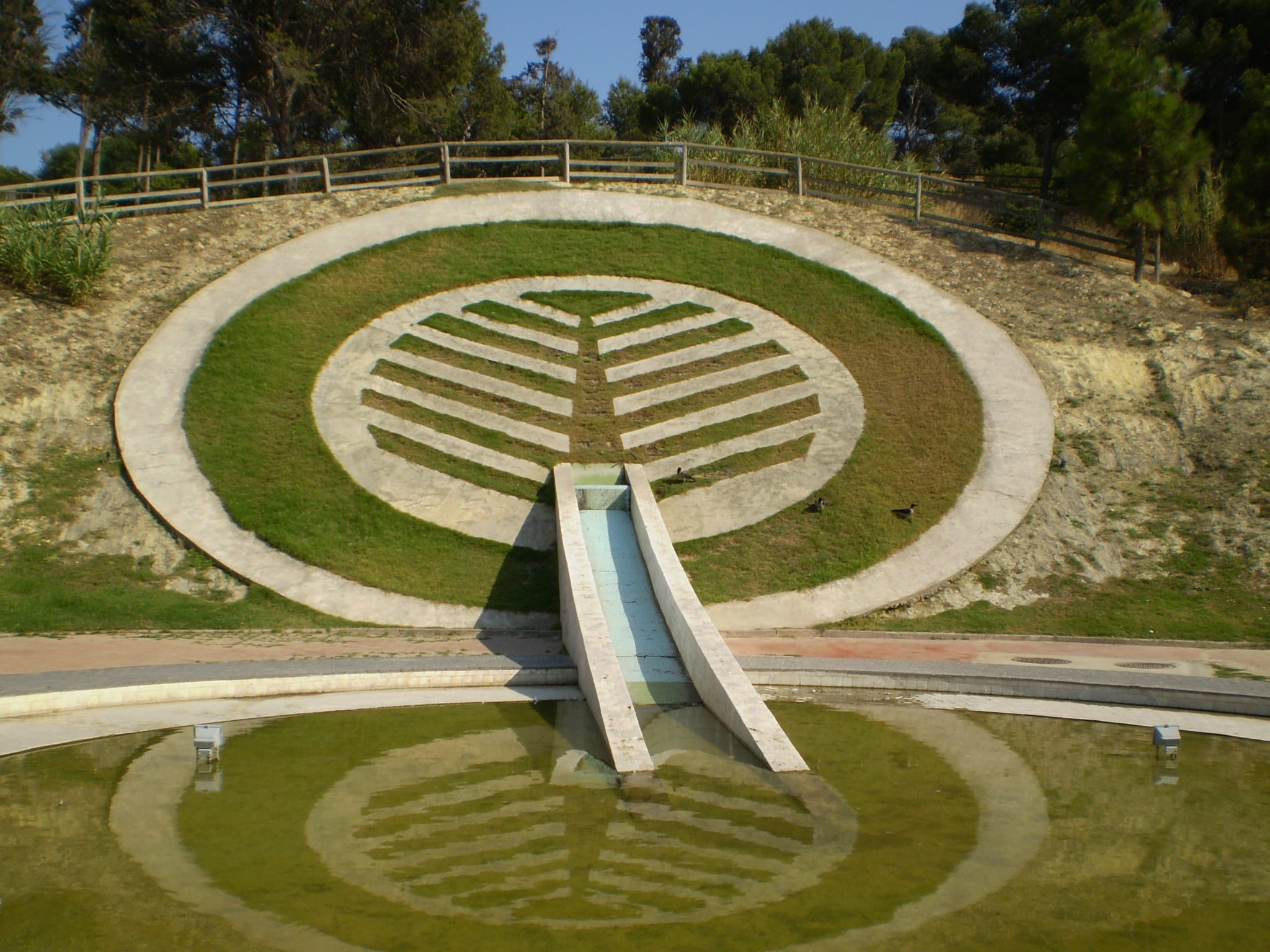
When you enter from the main gate, you’ll walk over a road lined by oak trees, alongside which are some of the stone “sound” sculptures done by the artist Pinuccio Sciola. If you rub one with your hand or a small stone, it makes pleasant sounds. The road winds past a picturesque pond home to water turtles, swans, geese and ducks. As you continue, you’ll come across the ‘fontana logo’, a pond equipped with technology that stages a fantastic series of jets of water. The symbol of the park is next to it: a stylised twig. The logo echoes a decoration from a bowl found in a tomb discovered in 1905. Monte Claro is, in fact, an archaeologically important area: the culture of Monte Claro gets its name from the traces of a pre-Nuragic settlement discovered here. The park is also home to the remains of a building that may have been used as a sacred well and, not far away, a mysterious 4th century BCE tomb where various amphora and the bones of a couple, buried in an embrace, were found. The mystery thickens, as this was the only Punic Age tomb discovered on the hill from an era when the vast, nearby necropolis of Tuvixeddu was still in use.
Aside from the historical and archaeological aspects, Monte Claro will surprise you for the richness of the vegetation that thrives here: carob, mastic, oleander, olive, pine, oak and willow trees, as well as mulberries, roses and hibiscus bushes. The tropical garden is home to such aromatic plants as laurel, myrtle and rosemary. The park is an ideal place for a nice jog or walk. Sports fields have also been laid out here, especially for soccer and five-a-side football, and there is a skating rink. There are even two areas set aside especially for dogs. Monte Claro is also a venue, especially in summer, for shows, concerts and a variety of cultural events.
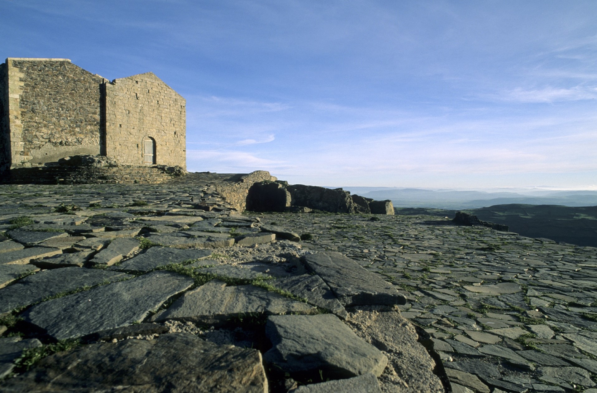
Nostra Signora di Bonaria - Osilo
It is the ‘highest’ church in the Sassari area and is the only Sardinian sanctuary dedicated to the protector of sailors built on a high ground, standing out against a spectacular landscape around it. Nostra Signora di Bonaria is located on the summit of one of the three peaks of Mount Tuffudesu, in the territory of Osilo, about three kilometres from the residential area. The current building dates back to the 17th century, although stories linked to the sanctuary tell us about a first stone laid in 1450, to thank the Madonna for having freed Osilo from a plague epidemic. The building is made of basalt and tuff ashlars and cannot be attributed to any particular architectural styles, apart from a few small concessions to the Baroque.
The church has a single nave and is barrel vaulted and divided into two bays by pilasters. There is a rectangular window on the right side. In the apse, which has a quadrangular floor plan, you will notice an unusual element: stone seats reserved for the choir, positioned on the sides of the altar. During its first phases of use, the sanctuary was regularly frequented but then went through a phase of total abandonment. Today it is the protagonist of a ritual that takes place every year on 15 August: from the Parish Church of Immacolata Concezione, worshippers set out in a procession, carrying the simulacrum of the Madonna di Bonaria, to place it in the niche behind the altar. In the evening of the same day, it’s time for the reverse route. The climb towards the hill takes place in its last stretch along a paved path and leads to the square, where your view will stretch for more than a hundred kilometres over the Gulf of Asinara and the Sassari area, up to Corsica on the clearest days. It is no coincidence that the church was used as a reference point in navigation, as it was visible from the sea thanks to its elevated position. Speaking of buildings on high ground, on the northern peak of Tuffudesu there is also the symbol of Osilo, at the foot of which the town developed: the Malaspina Castle. There are no certain sources that attest to the year of its construction, but it is thought to date back to the 12th century. Certainly during the following century, it was part of the possessions of the noble Malaspina family, who also boasted ownership of the Castle of Serravalle in Bosa. The building has an oval layout, surrounded by a mighty wall with two towers, one of which is circular and made of basalt and the other is square and made of tuff.
Other churches in Osilo are also worth a visit: in addition to the parish church, the Late-Renaissance Church of Nostra Signora del Rosario stands out. The Church of Santo Spirito stands in the northeastern outskirts of the village, while in the scenic ‘valley of the mills’, in the hamlet of San Lorenzo, you can visit the little church of the same name, already mentioned in 17th century sources and recently restored.